Bridge Statistics for Lennon, Michigan (MI)
Condition, Traffic, Stress, Structural Evaluation, Project Costs
- National Bridge Inventory (NBI) Statistics
- 19Number of bridges
- 141ft / 43.4mTotal length
- $136,000Total costs
- 136,733Total average daily traffic
- 18,486Total average daily truck traffic
- National Bridge Inventory (NBI) Registered Bridges for Lennon
- No street view available for this location
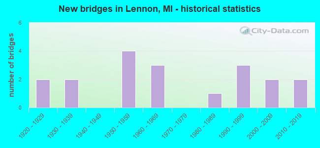
- New bridges - historical statistics
- 21920-1929
- 21930-1939
- 41950-1959
- 31960-1969
- 11980-1989
- 31990-1999
- 22000-2009
- 22010-2019


- Bridge Condition - Deck
- 21.4%Very good
- 35.7%Good
- 7.1%Satisfactory
- 28.6%Fair
- 7.1%Poor

- Bridge Condition - Superstructure
- 7.1%Excellent
- 21.4%Very good
- 21.4%Good
- 21.4%Satisfactory
- 14.3%Fair
- 7.1%Poor
- 7.1%Serious

- Bridge Condition - Substructure
- 14.3%Very good
- 57.1%Good
- 14.3%Satisfactory
- 14.3%Fair

- Bridge Condition - Channel
- 30.8%Very good
- 30.8%Good
- 23.1%Satisfactory
- 15.4%Fair

- Bridge Condition - Culverts
- 66.7%Good
- 33.3%Poor
Find on map >> Show street view
Structure Number: 2531, Location: @ SHIAWASSEE CO LINE (Lat: 42.964389, Lng: -83.928861), Route carried "on" structure: State highway 13, Year Built: 1959, Status: Open, Structure Length: 6.89m (22.60ft), Average Daily Traffic: 8,600 (year 2010), Truck Traffic: 7%, Average Future Daily Traffic: 10,000 (year 2031), Design Load: HS 20, Features Intersected: I-69
Minimum Vertical Clearance: 30.48m (100.00ft), Kilometerpoint: 0.270, Lanes on structure: 4, Lanes under structure: 4, Base Highway Network: Yes (Inventory Route: 149, Subroute: 1), Owner: State Highway Agency, Approaching Roadway Width: 20.3m (66.6ft), Material/Design: Concrete continuous, Design/Construction: Tee Beam, Number Of Spans In Main Unit: 4, Length of Maximum Span: 21.5m (70.5ft), Curb-To-Curb Width: 17.7m (58.1ft), Out-to-Out Width: 18.7m (61.4ft)
Condition: Deck: Fair, Superstructure: Fair, Substructure: Good, Operating Rating: 65.1 metric tons, Method Used To Determine Operating Rating: Load Factor (LF) rating reported by rating factor (RF) method using MS18 loading, Inventory Rating: 40.8 metric tons, Method Used To Determine Inventory Rating: Load Factor (LF) rating reported by rating factor (RF) method using MS18 loading, Structural Evaluation: Somewhat better than minimum adequacy, Deck Geometry: Somewhat better than minimum adequacy, Underclear: High priority of corrective action, Approach Roadway Alignment: Equal to present desirable criteria, Designated Inspection Frequency: Every 24 months, Inspection Date: July 2020, Deck Structure Type: Concrete Cast-file-Place, Wearing Surface/Protective System: Wearing Surface: Epoxy Overlay
Find on map >> Show street view
Structure Number: 2532, Location: 1.0 MI E OF M-13 (Lat: 42.964450, Lng: -83.909439), Route carried "on" structure: County highway , Year Built: 1959, Status: Open, Structure Length: 6.89m (22.60ft), Average Daily Traffic: 1,222 (year 1996), Truck Traffic: 3%, Average Future Daily Traffic: 2,200 (year 2016), Design Load: H 15, Features Intersected: I-69, Facility Carried by Structure: DUFFIELD RD
Minimum Vertical Clearance: 30.48m (100.00ft), Kilometerpoint: 0.838, Lanes on structure: 2, Lanes under structure: 4, Owner: State Highway Agency, Approaching Roadway Width: 10.9m (35.8ft), Material/Design: Concrete continuous, Design/Construction: Tee Beam, Number Of Spans In Main Unit: 4, Length of Maximum Span: 21.6m (70.9ft), Curb-To-Curb Width: 8.5m (27.9ft), Out-to-Out Width: 9.6m (31.5ft)
Condition: Deck: Good, Superstructure: Satisfactory, Substructure: Good, Operating Rating: 47.3 metric tons, Method Used To Determine Operating Rating: Load Factor (LF) rating reported by rating factor (RF) method using MS18 loading, Inventory Rating: 28.2 metric tons, Method Used To Determine Inventory Rating: Load Factor (LF) rating reported by rating factor (RF) method using MS18 loading, Structural Evaluation: Equal to present minimum criteria, Deck Geometry: Somewhat better than minimum adequacy, Underclear: Meets minimum limits, Approach Roadway Alignment: Equal to present desirable criteria, Designated Inspection Frequency: Every 24 months, Inspection Date: July 2020, Deck Structure Type: Concrete Cast-file-Place, Wearing Surface/Protective System: Wearing Surface: Monolithic Concrete
Find on map >> Show street view
Structure Number: 2572, Location: 2.1 MI E OF SHIAWASSEE CO (Lat: 43.000756, Lng: -83.887986), Route carried "on" structure: State highway 56, Year Built: 2010, Status: Open, Structure Length: 1.98m (6.50ft), Average Daily Traffic: 6,400 (year 2008), Truck Traffic: 4%, Average Future Daily Traffic: 7,900 (year 2031), Design Load: Greater than HL93, Features Intersected: MISTEQUAY CREEK, Facility Carried by Structure: M-21
Minimum Vertical Clearance: 30.48m (100.00ft), Kilometerpoint: 3.327, Lanes on structure: 2, Base Highway Network: Yes (Inventory Route: 149, Subroute: 7), Owner: State Highway Agency, Approaching Roadway Width: 21.9m (71.9ft), Skew: 4 degrees, Material/Design: Prestressed concrete, Design/Construction: Stringer/Multi-beam, Number Of Spans In Main Unit: 1, Length of Maximum Span: 17.8m (58.4ft), Curb-To-Curb Width: 26.2m (86.0ft), Out-to-Out Width: 27.2m (89.2ft)
Condition: Deck: Very good, Superstructure: Excellent, Substructure: Good, Channel: Good, Operating Rating: 73.1 metric tons, Method Used To Determine Operating Rating: Load Factor (LF), Inventory Rating: 39.1 metric tons, Method Used To Determine Inventory Rating: Load Factor (LF), Structural Evaluation: Better than present minimum criteria, Deck Geometry: Superior to present desirable criteria, Waterway Adequacy: Equal to present desirable criteria, Approach Roadway Alignment: Equal to present desirable criteria, Designated Inspection Frequency: Every 24 months, Inspection Date: March 2022, Deck Structure Type: Concrete Cast-file-Place, Wearing Surface/Protective System: Wearing Surface: Monolithic Concrete, Deck Protection: Epoxy Coated Reinforcing
Find on map >> Show street view
Structure Number: 2721, Location: BET DUFFIELD & M-13 (Lat: 43.029722, Lng: -83.919783), Route carried "on" structure: County highway , Year Built: 1928, Year Reconstructed: 2016, Status: Open, Structure Length: 1.07m (3.51ft), Average Daily Traffic: 925 (year 2018), Truck Traffic: 5%, Average Future Daily Traffic: 1,671 (year 2038), Design Load: Greater than HL93, Features Intersected: MISTEGUAY CREEK, Facility Carried by Structure: BEECHER ROAD
Minimum Vertical Clearance: 30.48m (100.00ft), Kilometerpoint: 0.700, Lanes on structure: 2, Owner: County Highway Agency, Approaching Roadway Width: 9.8m (32.2ft), Material/Design: Prestressed concrete, Design/Construction: Box Beam or Girders - Multiple, Number Of Spans In Main Unit: 1, Length of Maximum Span: 10.3m (33.8ft), Curb-To-Curb Width: 9.8m (32.2ft), Out-to-Out Width: 10.7m (35.1ft)
Condition: Deck: Very good, Superstructure: Very good, Substructure: Good, Channel: Very good, Operating Rating: 96.6 metric tons, Method Used To Determine Operating Rating: Load and Resistance Factor Rating (LRFR) rating reported by rating factor(RF) method using HL-93 loadings, Inventory Rating: 74.5 metric tons, Method Used To Determine Inventory Rating: Load and Resistance Factor Rating (LRFR) rating reported by rating factor(RF) method using HL-93 loadings, Structural Evaluation: Better than present minimum criteria, Deck Geometry: Equal to present minimum criteria, Waterway Adequacy: Equal to present desirable criteria, Approach Roadway Alignment: Superior to present desirable criteria, Designated Inspection Frequency: Every 24 months, Inspection Date: November 2020, Deck Structure Type: Concrete Cast-file-Place, Wearing Surface/Protective System: Deck Protection: Epoxy Coated Reinforcing
Find on map >> Show street view
Structure Number: 2773, Location: BET DUFFIELD & NICHOLS RD (Lat: 43.015197, Lng: -83.896469), Route carried "on" structure: County highway , Year Built: 1938, Status: Open, Structure Length: 1.12m (3.67ft), Average Daily Traffic: 91 (year 2018), Truck Traffic: 2%, Average Future Daily Traffic: 164 (year 2038), Design Load: HS 20+Mod, Features Intersected: MISTEGUAY CREEK, Facility Carried by Structure: CALKINS ROAD
Minimum Vertical Clearance: 30.48m (100.00ft), Kilometerpoint: 2.606, Lanes on structure: 2, Owner: County Highway Agency, Approaching Roadway Width: 9.1m (29.9ft), Skew: 2 degrees, Material/Design: Steel, Design/Construction: Stringer/Multi-beam, Number Of Spans In Main Unit: 1, Length of Maximum Span: 10.6m (34.8ft), Curb-To-Curb Width: 9.1m (29.9ft), Out-to-Out Width: 10.1m (33.1ft)
Condition: Deck: Poor, Superstructure: Serious, Substructure: Fair, Channel: Fair, Operating Rating: 62.5 metric tons, Method Used To Determine Operating Rating: Load Factor (LF) rating reported by rating factor (RF) method using MS18 loading, Inventory Rating: 37.6 metric tons, Method Used To Determine Inventory Rating: Load Factor (LF) rating reported by rating factor (RF) method using MS18 loading, Structural Evaluation: High priority of corrective action, Deck Geometry: Better than present minimum criteria, Waterway Adequacy: Equal to present desirable criteria, Approach Roadway Alignment: Equal to present desirable criteria, Length Of Structure Improvement: 1.13m (3.71ft), Designated Inspection Frequency: Every 12 months, Inspection Date: November 2021, Bridge Improvement Cost: $87,000, Roadway Improvement Cost: $9,000, Total Project Cost: $109,000, Deck Structure Type: Concrete Cast-file-Place, Wearing Surface/Protective System: Wearing Surface: Monolithic Concrete
Find on map >> Show street view
Structure Number: 2775, Location: BET CORUNNA & CALKINS RD (Lat: 43.005106, Lng: -83.890700), Route carried "on" structure: County highway , Year Built: 1930, Status: Posted for load, Structure Length: 1.37m (4.49ft), Average Daily Traffic: 221 (year 2009), Truck Traffic: 2%, Average Future Daily Traffic: 332 (year 2029), Design Load: HS 20+Mod, Features Intersected: MISTEGUAY CREEK, Facility Carried by Structure: NICHOLS ROAD
Minimum Vertical Clearance: 30.48m (100.00ft), Kilometerpoint: 5.337, Lanes on structure: 2, Owner: County Highway Agency, Approaching Roadway Width: 9.1m (29.9ft), Skew: 3 degrees, Material/Design: Steel, Design/Construction: Stringer/Multi-beam, Number Of Spans In Main Unit: 1, Length of Maximum Span: 13.4m (44.0ft), Curb-To-Curb Width: 9.1m (29.9ft), Out-to-Out Width: 11.0m (36.1ft)
Condition: Deck: Fair, Superstructure: Poor, Substructure: Fair, Channel: Satisfactory, Operating Rating: 31.4 metric tons, Method Used To Determine Operating Rating: Load Factor (LF) rating reported by rating factor (RF) method using MS18 loading, Inventory Rating: 18.8 metric tons, Method Used To Determine Inventory Rating: Load Factor (LF) rating reported by rating factor (RF) method using MS18 loading, Structural Evaluation: Meets minimum limits, Deck Geometry: Equal to present minimum criteria, Waterway Adequacy: Equal to present desirable criteria, Approach Roadway Alignment: Equal to present desirable criteria, Bridge Posting: Required (Relationship of Operating Rating to Maximum Legal Load: 30.0 - 39.9% below), Designated Inspection Frequency: Every 12 months, Inspection Date: November 2021, Deck Structure Type: Concrete Cast-file-Place, Wearing Surface/Protective System: Wearing Surface: Monolithic Concrete
Find on map >> Show street view
Structure Number: 9744, Location: 1.2 MI SW OF GENESEE COL (Lat: 42.962708, Lng: -83.950275), Route carried "on" structure: Interstate 69, Year Built: 1961, Status: Open, Structure Length: 5.43m (17.81ft), Average Daily Traffic: 14,378 (year 2007), Truck Traffic: 20%, Average Future Daily Traffic: 15,340 (year 2018), Design Load: HS 20, Features Intersected: HURON & EASTERN RR
Minimum Vertical Clearance: 30.48m (100.00ft), Kilometerpoint: 39.511, Lanes on structure: 2, Base Highway Network: Yes (Inventory Route: 55, Subroute: 8), Owner: State Highway Agency, Approaching Roadway Width: 14.0m (45.9ft), Skew: 13 degrees, Material/Design: Steel, Design/Construction: Stringer/Multi-beam, Number Of Spans In Main Unit: 3, Length of Maximum Span: 18.0m (59.1ft), Curb-To-Curb Width: 12.8m (42.0ft), Out-to-Out Width: 14.4m (47.2ft)
Condition: Deck: Fair, Superstructure: Satisfactory, Substructure: Satisfactory, Operating Rating: 60.3 metric tons, Method Used To Determine Operating Rating: Load Factor (LF) rating reported by rating factor (RF) method using MS18 loading, Inventory Rating: 36.0 metric tons, Method Used To Determine Inventory Rating: Load Factor (LF) rating reported by rating factor (RF) method using MS18 loading, Structural Evaluation: Equal to present minimum criteria, Deck Geometry: Equal to present desirable criteria, Approach Roadway Alignment: Equal to present desirable criteria, Designated Inspection Frequency: Every 24 months, Inspection Date: June 2021, Deck Structure Type: Concrete Cast-file-Place, Wearing Surface/Protective System: Wearing Surface: Latex Concrete
Find on map >> Show street view
Structure Number: 9745, Location: 1.2 MI SW OF GENESEE COL (Lat: 42.963000, Lng: -83.949997), Route carried "on" structure: Interstate 69, Year Built: 1961, Status: Open, Structure Length: 5.43m (17.81ft), Average Daily Traffic: 14,378 (year 2007), Truck Traffic: 20%, Average Future Daily Traffic: 15,340 (year 2018), Design Load: HS 20, Features Intersected: HURON & EASTERN RR
Minimum Vertical Clearance: 30.48m (100.00ft), Kilometerpoint: 39.532, Lanes on structure: 2, Base Highway Network: Yes (Inventory Route: 55, Subroute: 9), Owner: State Highway Agency, Approaching Roadway Width: 14.0m (45.9ft), Skew: 13 degrees, Material/Design: Steel, Design/Construction: Stringer/Multi-beam, Number Of Spans In Main Unit: 3, Length of Maximum Span: 18.0m (59.1ft), Curb-To-Curb Width: 12.8m (42.0ft), Out-to-Out Width: 14.4m (47.2ft)
Condition: Deck: Fair, Superstructure: Satisfactory, Substructure: Satisfactory, Operating Rating: 56.1 metric tons, Method Used To Determine Operating Rating: Load Factor (LF) rating reported by rating factor (RF) method using MS18 loading, Inventory Rating: 33.4 metric tons, Method Used To Determine Inventory Rating: Load Factor (LF) rating reported by rating factor (RF) method using MS18 loading, Structural Evaluation: Equal to present minimum criteria, Deck Geometry: Equal to present desirable criteria, Approach Roadway Alignment: Equal to present desirable criteria, Designated Inspection Frequency: Every 24 months, Inspection Date: June 2021, Deck Structure Type: Concrete Cast-file-Place, Wearing Surface/Protective System: Wearing Surface: Epoxy Overlay
Find on map >> Show street view
Structure Number: 9774, Location: 0.6 MI W OF GENESEE COL (Lat: 42.998817, Lng: -83.939261), Route carried "on" structure: State highway 21, Year Built: 2009, Status: Open, Structure Length: 0.86m (2.82ft), Average Daily Traffic: 8,200 (year 2009), Truck Traffic: 5%, Average Future Daily Traffic: 9,200 (year 2029), Design Load: Greater than HL93, Features Intersected: CRAWFORD DRAIN
Minimum Vertical Clearance: 30+ m (98+ ft), Kilometerpoint: 34.892, Lanes on structure: 2, Base Highway Network: Yes (Inventory Route: 55, Subroute: 10), Owner: State Highway Agency, Approaching Roadway Width: 13.4m (44.0ft), Skew: 4 degrees, Material/Design: Concrete, Design/Construction: Culvert, Number Of Spans In Main Unit: 1, Length of Maximum Span: 8.6m (28.2ft), Curb-To-Curb Width: 13.4m (44.0ft), Out-to-Out Width: 14.9m (48.9ft)
Condition: Channel: Satisfactory, Culverts: Good, Operating Rating: 62.0 metric tons, Method Used To Determine Operating Rating: Load and Resistance Factor (LRFR), Inventory Rating: 42.7 metric tons, Method Used To Determine Inventory Rating: Load and Resistance Factor (LRFR), Structural Evaluation: Better than present minimum criteria, Deck Geometry: Equal to present minimum criteria, Waterway Adequacy: Equal to present desirable criteria, Approach Roadway Alignment: Equal to present desirable criteria, Designated Inspection Frequency: Every 24 months, Inspection Date: July 2021, Deck Structure Type: Concrete Precast Panels, Wearing Surface/Protective System: Wearing Surface: Bituminous
Find on map >> Show street view
Structure Number: 9777, Location: 2.8 MI W OF GENESEE COL (Lat: 42.999536, Lng: -83.986589), Route carried "on" structure: State highway 21, Year Built: 1929, Status: Open, Structure Length: 0.73m (2.40ft), Average Daily Traffic: 7,975 (year 2007), Truck Traffic: 6%, Average Future Daily Traffic: 8,677 (year 2018), Features Intersected: RUSH CREEK
Minimum Vertical Clearance: 30.48m (100.00ft), Kilometerpoint: 31.032, Lanes on structure: 2, Base Highway Network: Yes (Inventory Route: 55, Subroute: 10), Owner: State Highway Agency, Approaching Roadway Width: 10.9m (35.8ft), Skew: 4 degrees, Material/Design: Concrete, Design/Construction: Culvert, Number Of Spans In Main Unit: 1, Length of Maximum Span: 6.4m (21.0ft), Curb or Sidewalk Widths: Left: 0.7m (2.3ft), Right: 0.7m (2.3ft), Out-to-Out Width: 46.9m (153.9ft)
Condition: Channel: Fair, Culverts: Poor, Operating Rating: 89.1 metric tons, Method Used To Determine Operating Rating: Load Factor (LF) rating reported by rating factor (RF) method using MS18 loading, Inventory Rating: 53.1 metric tons, Method Used To Determine Inventory Rating: Load Factor (LF) rating reported by rating factor (RF) method using MS18 loading, Structural Evaluation: Meets minimum limits, Waterway Adequacy: Equal to present minimum criteria, Approach Roadway Alignment: Equal to present desirable criteria, Length Of Structure Improvement: 0.46m (1.51ft), Designated Inspection Frequency: Every 12 months, Inspection Date: July 2021, Bridge Improvement Cost: $24,000, Roadway Improvement Cost: $2,000, Total Project Cost: $27,000 ( Estimate for 2050)
Find on map >> Show street view
Structure Number: 9778, Location: 1.6 MI W OF GENESEE COL (Lat: 42.999253, Lng: -83.961628), Route carried "on" structure: State highway 21, Year Built: 2009, Status: Open, Structure Length: 0.80m (2.62ft), Average Daily Traffic: 8,200 (year 2009), Truck Traffic: 5%, Average Future Daily Traffic: 9,200 (year 2029), Design Load: HS 25 or greater, Features Intersected: LIMBARG COUNTY DRAIN
Minimum Vertical Clearance: 30.48m (100.00ft), Kilometerpoint: 33.067, Lanes on structure: 2, Base Highway Network: Yes (Inventory Route: 55, Subroute: 10), Owner: State Highway Agency, Approaching Roadway Width: 13.4m (44.0ft), Skew: 4 degrees, Material/Design: Concrete, Design/Construction: Culvert, Number Of Spans In Main Unit: 1, Length of Maximum Span: 8.0m (26.2ft), Curb-To-Curb Width: 13.4m (44.0ft), Out-to-Out Width: 14.9m (48.9ft)
Condition: Channel: Very good, Culverts: Good, Operating Rating: 51.2 metric tons, Method Used To Determine Operating Rating: Load and Resistance Factor Rating (LRFR) rating reported by rating factor(RF) method using HL-93 loadings, Inventory Rating: 39.5 metric tons, Method Used To Determine Inventory Rating: Load and Resistance Factor Rating (LRFR) rating reported by rating factor(RF) method using HL-93 loadings, Structural Evaluation: Better than present minimum criteria, Deck Geometry: Equal to present minimum criteria, Waterway Adequacy: Better than present minimum criteria, Approach Roadway Alignment: Equal to present desirable criteria, Designated Inspection Frequency: Every 24 months, Inspection Date: July 2021
Find on map >> Show street view
Structure Number: 982, Location: 7 MILES NORTH OF DURAND (Lat: 43.019922, Lng: -83.987081), Route carried "on" structure: County highway 7687, Year Built: 1968, Status: Open, Structure Length: 1.79m (5.87ft), Average Daily Traffic: 1,241 (year 2011), Truck Traffic: 5%, Average Future Daily Traffic: 1,844 (year 2031), Design Load: HS 20, Features Intersected: RUSHBED CREEK, Facility Carried by Structure: DURAND ROAD
Minimum Vertical Clearance: 30.48m (100.00ft), Kilometerpoint: 20.744, Lanes on structure: 2, Owner: County Highway Agency, Approaching Roadway Width: 9.1m (29.9ft), Material/Design: Steel continuous, Design/Construction: Stringer/Multi-beam, Number Of Spans In Main Unit: 2, Length of Maximum Span: 8.2m (26.9ft), Curb or Sidewalk Widths: Left: 0.6m (2.0ft), Right: 0.6m (2.0ft), Curb-To-Curb Width: 9.1m (29.9ft), Out-to-Out Width: 9.6m (31.5ft)
Condition: Deck: Good, Superstructure: Good, Substructure: Good, Channel: Good, Operating Rating: 45.7 metric tons, Method Used To Determine Operating Rating: Load Factor (LF) rating reported by rating factor (RF) method using MS18 loading, Inventory Rating: 27.2 metric tons, Method Used To Determine Inventory Rating: Load Factor (LF) rating reported by rating factor (RF) method using MS18 loading, Structural Evaluation: Equal to present minimum criteria, Deck Geometry: Somewhat better than minimum adequacy, Waterway Adequacy: Equal to present desirable criteria, Approach Roadway Alignment: Equal to present desirable criteria, Designated Inspection Frequency: Every 24 months, Inspection Date: March 2022, Deck Structure Type: Concrete Cast-file-Place, Wearing Surface/Protective System: Wearing Surface: Bituminous
Find on map >> Show street view
Structure Number: 9834, Location: 1.3 MI SE OF JUDDVILLE (Lat: 43.044358, Lng: -83.956533), Route carried "on" structure: County highway , Year Built: 1991, Status: Open, Structure Length: 1.85m (6.07ft), Average Daily Traffic: 203 (year 2019), Truck Traffic: 5%, Average Future Daily Traffic: 248 (year 2039), Design Load: HS 20, Features Intersected: MISTEGUAY CREEK DRAIN, Facility Carried by Structure: CRONK RD
Minimum Vertical Clearance: 30.48m (100.00ft), Kilometerpoint: 1.640, Lanes on structure: 2, Owner: County Highway Agency, Approaching Roadway Width: 10.0m (32.8ft), Skew: 1 degrees, Material/Design: Prestressed concrete, Design/Construction: Box Beam or Girders - Multiple, Number Of Spans In Main Unit: 1, Length of Maximum Span: 17.0m (55.8ft), Curb-To-Curb Width: 10.6m (34.8ft), Out-to-Out Width: 11.4m (37.4ft)
Condition: Deck: Good, Superstructure: Good, Substructure: Good, Channel: Satisfactory, Operating Rating: 65.8 metric tons, Method Used To Determine Operating Rating: Load Factor (LF) rating reported by rating factor (RF) method using MS18 loading, Inventory Rating: 39.2 metric tons, Method Used To Determine Inventory Rating: Load Factor (LF) rating reported by rating factor (RF) method using MS18 loading, Structural Evaluation: Better than present minimum criteria, Deck Geometry: Better than present minimum criteria, Waterway Adequacy: Equal to present minimum criteria, Approach Roadway Alignment: Better than present minimum criteria, Designated Inspection Frequency: Every 19 months, Inspection Date: October 2020, Deck Structure Type: Concrete Precast Panels, Wearing Surface/Protective System: Wearing Surface: Bituminous, Membrane: Preformed Fabric
Find on map >> Show street view
Structure Number: 9866, Location: 3 MI S OF JUDDVILLE (Lat: 43.013986, Lng: -83.983419), Route carried "on" structure: County highway , Year Built: 1996, Status: Open, Structure Length: 1.22m (4.00ft), Average Daily Traffic: 178 (year 1998), Truck Traffic: 5%, Average Future Daily Traffic: 320 (year 2018), Design Load: HS 20, Features Intersected: RUSHBED CREEK, Facility Carried by Structure: COPAS RD
Minimum Vertical Clearance: 30.48m (100.00ft), Kilometerpoint: 0.299, Lanes on structure: 2, Owner: County Highway Agency, Approaching Roadway Width: 6.1m (20.0ft), Material/Design: Prestressed concrete, Design/Construction: Box Beam or Girders - Multiple, Number Of Spans In Main Unit: 1, Length of Maximum Span: 11.0m (36.1ft), Curb-To-Curb Width: 9.1m (29.9ft), Out-to-Out Width: 9.6m (31.5ft)
Condition: Deck: Good, Superstructure: Very good, Substructure: Good, Channel: Good, Operating Rating: 97.2 metric tons, Method Used To Determine Operating Rating: Load Factor (LF) rating reported by rating factor (RF) method using MS18 loading, Inventory Rating: 61.9 metric tons, Method Used To Determine Inventory Rating: Load Factor (LF) rating reported by rating factor (RF) method using MS18 loading, Structural Evaluation: Better than present minimum criteria, Deck Geometry: Equal to present minimum criteria, Waterway Adequacy: Better than present minimum criteria, Approach Roadway Alignment: Equal to present minimum criteria, Designated Inspection Frequency: Every 24 months, Inspection Date: March 2022, Deck Structure Type: Concrete Cast-file-Place, Wearing Surface/Protective System: Wearing Surface: Monolithic Concrete, Deck Protection: Epoxy Coated Reinforcing
Find on map >> Show street view
Structure Number: 9867, Location: 2.5 MI S OF JUDDVILLE (Lat: 43.021058, Lng: -83.994264), Route carried "on" structure: County highway , Year Built: 1985, Status: Open, Structure Length: 1.95m (6.40ft), Average Daily Traffic: 385 (year 2011), Truck Traffic: 5%, Average Future Daily Traffic: 572 (year 2031), Design Load: HS 20+Mod, Features Intersected: RUSHBED CREEK, Facility Carried by Structure: MIDDLETON RD
Minimum Vertical Clearance: 30.48m (100.00ft), Kilometerpoint: 1.011, Lanes on structure: 2, Owner: County Highway Agency, Approaching Roadway Width: 10.1m (33.1ft), Material/Design: Prestressed concrete, Design/Construction: Box Beam or Girders - Multiple, Number Of Spans In Main Unit: 1, Length of Maximum Span: 18.2m (59.7ft), Curb-To-Curb Width: 9.1m (29.9ft), Out-to-Out Width: 9.4m (30.8ft)
Condition: Deck: Good, Superstructure: Good, Substructure: Very good, Channel: Very good, Operating Rating: 56.4 metric tons, Method Used To Determine Operating Rating: Load Factor (LF) rating reported by rating factor (RF) method using MS18 loading, Inventory Rating: 33.7 metric tons, Method Used To Determine Inventory Rating: Load Factor (LF) rating reported by rating factor (RF) method using MS18 loading, Structural Evaluation: Better than present minimum criteria, Deck Geometry: Equal to present minimum criteria, Waterway Adequacy: Better than present minimum criteria, Approach Roadway Alignment: Better than present minimum criteria, Designated Inspection Frequency: Every 24 months, Inspection Date: March 2022, Deck Structure Type: Concrete Cast-file-Place, Wearing Surface/Protective System: Wearing Surface: Bituminous, Membrane: Preformed Fabric, Deck Protection: Epoxy Coated Reinforcing
Find on map >> Show street view
Structure Number: 987, Location: 2.4 MI SE OF JUDDVILLE (Lat: 43.039522, Lng: -83.948258), Route carried "on" structure: County highway , Year Built: 1996, Status: Open, Structure Length: 1.82m (5.97ft), Average Daily Traffic: 92 (year 1998), Truck Traffic: 5%, Average Future Daily Traffic: 165 (year 2018), Design Load: HS 20, Features Intersected: MISTEGUAY CREEK, Facility Carried by Structure: BYRON RD
Minimum Vertical Clearance: 30.48m (100.00ft), Kilometerpoint: 7.390, Lanes on structure: 2, Owner: County Highway Agency, Approaching Roadway Width: 7.0m (23.0ft), Material/Design: Prestressed concrete, Design/Construction: Box Beam or Girders - Multiple, Number Of Spans In Main Unit: 1, Length of Maximum Span: 17.6m (57.7ft), Curb-To-Curb Width: 9.0m (29.5ft), Out-to-Out Width: 9.4m (30.8ft)
Condition: Deck: Satisfactory, Superstructure: Fair, Substructure: Good, Channel: Good, Operating Rating: 64.5 metric tons, Method Used To Determine Operating Rating: Load Factor (LF) rating reported by rating factor (RF) method using MS18 loading, Inventory Rating: 38.6 metric tons, Method Used To Determine Inventory Rating: Load Factor (LF) rating reported by rating factor (RF) method using MS18 loading, Structural Evaluation: Somewhat better than minimum adequacy, Deck Geometry: Better than present minimum criteria, Waterway Adequacy: Better than present minimum criteria, Approach Roadway Alignment: Better than present minimum criteria, Designated Inspection Frequency: Every 24 months, Inspection Date: March 2022, Deck Structure Type: Concrete Cast-file-Place, Wearing Surface/Protective System: Wearing Surface: Monolithic Concrete, Deck Protection: Epoxy Coated Reinforcing
Find on map >> Show street view
Structure Number: 9876, Location: 3.25 MI NE OF DURAND (Lat: 42.951331, Lng: -83.954300), Route carried "on" structure: County highway , Year Built: 2018, Status: Open, Structure Length: 2.19m (7.19ft), Average Daily Traffic: 4,142 (year 2017), Truck Traffic: 5%, Average Future Daily Traffic: 5,054 (year 2037), Design Load: Greater than HL93, Features Intersected: WEBB CREEK, Facility Carried by Structure: GOODALL RD
Minimum Vertical Clearance: 30.48m (100.00ft), Kilometerpoint: 7.474, Lanes on structure: 2, Owner: County Highway Agency, Approaching Roadway Width: 12.2m (40.0ft), Skew: 2 degrees, Material/Design: Prestressed concrete, Design/Construction: Box Beam or Girders - Single/Spread, Number Of Spans In Main Unit: 1, Length of Maximum Span: 21.5m (70.5ft), Curb-To-Curb Width: 12.2m (40.0ft), Out-to-Out Width: 12.9m (42.3ft)
Condition: Deck: Very good, Superstructure: Very good, Substructure: Very good, Channel: Very good, Operating Rating: 62.9 metric tons, Method Used To Determine Operating Rating: Load and Resistance Factor Rating (LRFR) rating reported by rating factor(RF) method using HL-93 loadings, Inventory Rating: 48.3 metric tons, Method Used To Determine Inventory Rating: Load and Resistance Factor Rating (LRFR) rating reported by rating factor(RF) method using HL-93 loadings, Structural Evaluation: Equal to present desirable criteria, Deck Geometry: Equal to present minimum criteria, Waterway Adequacy: Equal to present desirable criteria, Approach Roadway Alignment: Equal to present desirable criteria, Designated Inspection Frequency: Every 19 months, Inspection Date: October 2020, Deck Structure Type: Concrete Cast-file-Place, Wearing Surface/Protective System: Wearing Surface: Monolithic Concrete, Deck Protection: Epoxy Coated Reinforcing
Find on map >> Show street view
Structure Number: 2531, Location: @ SHIAWASSEE CO LINE (Lat: 42.964389, Lng: -83.928861), Route carried "under" structure: Interstate 69, Year Built: 1959, Structure Length: 0. m, Average Daily Traffic: 29,000 (year 2010), Truck Traffic: 17%, Features Intersected: I-69, Facility Carried by Structure: M-13
Minimum Vertical Clearance: 5.46m (17.91ft), Kilometerpoint: 0.000, Lanes on structure: 4, Lanes under structure: 4, Material/Design: Concrete continuous, Design/Construction: Tee Beam, Length of Maximum Span: 21.5m (70.5ft)
Find on map >> Show street view
Structure Number: 2532, Location: 1.0 MI E OF M-13 (Lat: 42.964450, Lng: -83.909439), Route carried "under" structure: Interstate 69, Year Built: 1959, Structure Length: 0. m, Average Daily Traffic: 30,902 (year 2007), Truck Traffic: 17%, Features Intersected: I-69, Facility Carried by Structure: DUFFIELD RD
Minimum Vertical Clearance: 5.05m (16.57ft), Kilometerpoint: 1.585, Lanes on structure: 2, Lanes under structure: 4, Material/Design: Concrete continuous, Design/Construction: Tee Beam, Length of Maximum Span: 21.6m (70.9ft)