Bridge Statistics for Lewistown, Missouri (MO)
Condition, Traffic, Stress, Structural Evaluation, Project Costs
- National Bridge Inventory (NBI) Statistics
- 12Number of bridges
- 62ft / 18.8mTotal length
- $536,000Total costs
- 639Total average daily traffic
- 49Total average daily truck traffic
- 844Total future (year 2040) average daily traffic
- National Bridge Inventory (NBI) Registered Bridges for Lewistown
- No street view available for this location
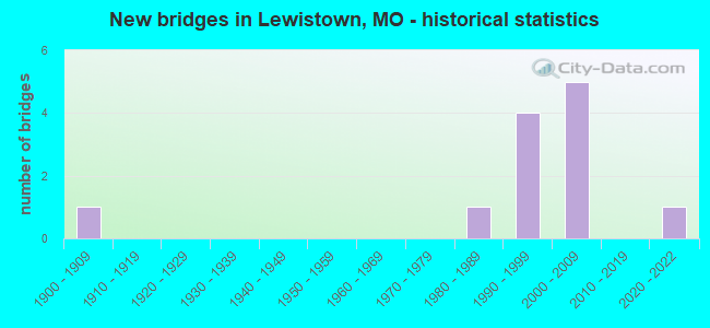
- New bridges - historical statistics
- 11900-1909
- 11980-1989
- 41990-1999
- 52000-2009
- 12020-2022

- Bridge Condition - Deck
- 16.7%Excellent
- 16.7%Very good
- 66.7%Good

- Bridge Condition - Superstructure
- 8.3%Excellent
- 50.0%Good
- 33.3%Satisfactory
- 8.3%Poor

- Bridge Condition - Substructure
- 16.7%Excellent
- 8.3%Very good
- 50.0%Satisfactory
- 16.7%Fair
- 8.3%Poor

- Bridge Condition - Channel
- 8.3%Excellent
- 50.0%Satisfactory
- 41.7%Fair
Find on map >> Show street view
Structure Number: 14791, Location: S 31 T 62 N R 8 W (Lat: 40.122556, Lng: -91.830944), Route carried "on" structure: County highway 75, Year Built: 1989, Status: Open, Structure Length: 1.52m (4.99ft), Average Daily Traffic: 75 (year 2020), Truck Traffic: 10%, Average Future Daily Traffic: 94 (year 2040), Features Intersected: REDDISH BR - M FAB, Facility Carried by Structure: COUNTY RD 322
Minimum Vertical Clearance: 30+ m (98+ ft), Kilometerpoint: 7.242, Lanes on structure: 1, Owner: County Highway Agency, Approaching Roadway Width: 5.5m (18.0ft), Material/Design: Steel, Design/Construction: Stringer/Multi-beam, Number Of Spans In Main Unit: 1, Length of Maximum Span: 14.6m (47.9ft), Curb-To-Curb Width: 5.5m (18.0ft), Out-to-Out Width: 5.5m (18.0ft)
Condition: Deck: Good, Superstructure: Satisfactory, Substructure: Satisfactory, Channel: Fair, Operating Rating: 49.5 metric tons, Method Used To Determine Operating Rating: Allowable Stress (AS), Inventory Rating: 30.6 metric tons, Method Used To Determine Inventory Rating: Allowable Stress (AS), Structural Evaluation: Equal to present minimum criteria, Deck Geometry: Meets minimum limits, Waterway Adequacy: Better than present minimum criteria, Approach Roadway Alignment: Equal to present minimum criteria, Designated Inspection Frequency: Every 24 months, Inspection Date: January 2022, Deck Structure Type: Concrete Cast-file-Place
Find on map >> Show street view
Structure Number: 16853, Location: S 24 T 61 N R 9 W (Lat: 40.072944, Lng: -91.838472), Route carried "on" structure: County highway 134, Year Built: 1997, Status: Open, Structure Length: 1.37m (4.49ft), Average Daily Traffic: 50 (year 2020), Truck Traffic: 10%, Average Future Daily Traffic: 63 (year 2040), Features Intersected: GRASSY CR, Facility Carried by Structure: COUNTY RD 208
Minimum Vertical Clearance: 30+ m (98+ ft), Kilometerpoint: 3.541, Lanes on structure: 2, Owner: County Highway Agency, Approaching Roadway Width: 6.1m (20.0ft), Material/Design: Steel, Design/Construction: Stringer/Multi-beam, Number Of Spans In Main Unit: 1, Length of Maximum Span: 13.4m (44.0ft), Curb-To-Curb Width: 5.5m (18.0ft), Out-to-Out Width: 5.5m (18.0ft)
Condition: Deck: Good, Superstructure: Good, Substructure: Fair, Channel: Fair, Operating Rating: 47.7 metric tons, Method Used To Determine Operating Rating: Load Factor (LF), Inventory Rating: 28.8 metric tons, Method Used To Determine Inventory Rating: Load Factor (LF), Structural Evaluation: Somewhat better than minimum adequacy, Deck Geometry: Meets minimum limits, Waterway Adequacy: Equal to present minimum criteria, Approach Roadway Alignment: Equal to present desirable criteria, Designated Inspection Frequency: Every 24 months, Inspection Date: January 2022, Deck Structure Type: Concrete Cast-file-Place
Find on map >> Show street view
Structure Number: 17365, Location: S 30 T 61 N R 8 W (Lat: 40.063750, Lng: -91.828444), Route carried "on" structure: County highway 150, Year Built: 1999, Status: Open, Structure Length: 1.37m (4.49ft), Average Daily Traffic: 30 (year 2020), Truck Traffic: 10%, Average Future Daily Traffic: 38 (year 2040), Design Load: HS 20, Features Intersected: GRASSY CR, Facility Carried by Structure: COUNTY RD 219
Minimum Vertical Clearance: 30+ m (98+ ft), Kilometerpoint: 1.287, Lanes on structure: 2, Owner: County Highway Agency, Approaching Roadway Width: 5.8m (19.0ft), Material/Design: Steel, Design/Construction: Stringer/Multi-beam, Number Of Spans In Main Unit: 1, Length of Maximum Span: 13.4m (44.0ft), Curb-To-Curb Width: 5.5m (18.0ft), Out-to-Out Width: 5.5m (18.0ft)
Condition: Deck: Good, Superstructure: Good, Substructure: Fair, Channel: Fair, Operating Rating: 89.1 metric tons, Method Used To Determine Operating Rating: Load Factor (LF), Inventory Rating: 67.5 metric tons, Method Used To Determine Inventory Rating: Load Factor (LF), Structural Evaluation: Somewhat better than minimum adequacy, Deck Geometry: Meets minimum limits, Waterway Adequacy: Equal to present minimum criteria, Approach Roadway Alignment: Equal to present desirable criteria, Designated Inspection Frequency: Every 24 months, Inspection Date: January 2022, Deck Structure Type: Concrete Cast-file-Place
Find on map >> Show street view
Structure Number: 17423, Location: S 5 T 61 N R 8 W (Lat: 40.121661, Lng: -91.806281), Route carried "on" structure: County highway 152, Year Built: 1900, Status: Posted for load, Structure Length: 3.96m (12.99ft), Average Daily Traffic: 25 (year 2020), Truck Traffic: 10%, Average Future Daily Traffic: 31 (year 2040), Features Intersected: MID FABIUS RVR, Facility Carried by Structure: COUNTY RD 329
Minimum Vertical Clearance: 3.96m (12.99ft), Kilometerpoint: 0.483, Lanes on structure: 1, Owner: County Highway Agency, Approaching Roadway Width: 5.5m (18.0ft), Material/Design: Steel, Design/Construction: Truss - Thru, Number Of Spans In Main Unit: 1, Number Of Approach Spans: 2, Length of Maximum Span: 30.6m (100.4ft), Curb-To-Curb Width: 3.7m (12.1ft), Out-to-Out Width: 3.7m (12.1ft)
Condition: Deck: Good, Superstructure: Poor, Substructure: Poor, Channel: Satisfactory, Operating Rating: 17.1 metric tons, Method Used To Determine Operating Rating: Load Factor (LF), Inventory Rating: 9.9 metric tons, Method Used To Determine Inventory Rating: Load Factor (LF), Structural Evaluation: High priority of replacement, Deck Geometry: High priority of replacement, Waterway Adequacy: Somewhat better than minimum adequacy, Approach Roadway Alignment: Meets minimum limits, Bridge Posting: Required (Relationship of Operating Rating to Maximum Legal Load: > 39.9% below), Length Of Structure Improvement: 0.49m (1.61ft), Designated Inspection Frequency: Every 24 months, Critical Feature Inspection Frequency: Every 24 months, Inspection Date: January 2022, Critical Feature Inspection Date: January 2022, Bridge Improvement Cost: $357,000, Roadway Improvement Cost: $36,000, Total Project Cost: $536,000 ( Estimate for 2022), Deck Structure Type: Concrete Cast-file-Place
Find on map >> Show street view
Structure Number: 17472, Location: S 28 T 61 N R 8 W (Lat: 40.054667, Lng: -91.795583), Route carried "on" structure: County highway 153, Year Built: 1999, Status: Open, Structure Length: 1.40m (4.59ft), Average Daily Traffic: 35 (year 2020), Truck Traffic: 10%, Average Future Daily Traffic: 44 (year 2040), Design Load: HS 20, Features Intersected: GRASSY CR, Facility Carried by Structure: COUNTY RD 201
Minimum Vertical Clearance: 30+ m (98+ ft), Kilometerpoint: 4.184, Lanes on structure: 2, Owner: County Highway Agency, Approaching Roadway Width: 5.5m (18.0ft), Material/Design: Steel, Design/Construction: Stringer/Multi-beam, Number Of Spans In Main Unit: 1, Length of Maximum Span: 13.7m (44.9ft), Curb-To-Curb Width: 5.4m (17.7ft), Out-to-Out Width: 5.4m (17.7ft)
Condition: Deck: Very good, Superstructure: Good, Substructure: Satisfactory, Channel: Satisfactory, Operating Rating: 69.3 metric tons, Method Used To Determine Operating Rating: Load Factor (LF), Inventory Rating: 41.4 metric tons, Method Used To Determine Inventory Rating: Load Factor (LF), Structural Evaluation: Equal to present minimum criteria, Deck Geometry: High priority of corrective action, Waterway Adequacy: Equal to present minimum criteria, Approach Roadway Alignment: Equal to present desirable criteria, Designated Inspection Frequency: Every 24 months, Inspection Date: January 2022, Deck Structure Type: Concrete Cast-file-Place
Find on map >> Show street view
Structure Number: 17641, Location: S 23 T 61 N R 8 W (Lat: 40.065056, Lng: -91.758083), Route carried "on" structure: County highway 158, Year Built: 1998, Status: Open, Structure Length: 0.91m (2.99ft), Average Daily Traffic: 25 (year 2020), Truck Traffic: 10%, Average Future Daily Traffic: 31 (year 2040), Design Load: HS 20, Features Intersected: BR OF MID FABIUS R, Facility Carried by Structure: COUNTY RD 505
Minimum Vertical Clearance: 30+ m (98+ ft), Kilometerpoint: 2.575, Lanes on structure: 2, Owner: County Highway Agency, Approaching Roadway Width: 5.5m (18.0ft), Material/Design: Steel, Design/Construction: Stringer/Multi-beam, Number Of Spans In Main Unit: 1, Length of Maximum Span: 8.8m (28.9ft), Curb-To-Curb Width: 5.5m (18.0ft), Out-to-Out Width: 5.5m (18.0ft)
Condition: Deck: Very good, Superstructure: Good, Substructure: Satisfactory, Channel: Satisfactory, Inventory Rating: 90.0 metric tons, Method Used To Determine Inventory Rating: Load Factor (LF), Structural Evaluation: Equal to present minimum criteria, Deck Geometry: Meets minimum limits, Waterway Adequacy: Equal to present minimum criteria, Approach Roadway Alignment: Equal to present desirable criteria, Designated Inspection Frequency: Every 24 months, Inspection Date: January 2022, Deck Structure Type: Concrete Cast-file-Place
Find on map >> Show street view
Structure Number: 28919, Location: S 8 T 61 N R 8 W (Lat: 40.101028, Lng: -91.808417), Route carried "on" structure: County highway 151, Year Built: 2001, Status: Open, Structure Length: 1.04m (3.41ft), Average Daily Traffic: 35 (year 2020), Truck Traffic: 10%, Average Future Daily Traffic: 44 (year 2040), Features Intersected: BR MIDDLE FABUIS R, Facility Carried by Structure: COUNTY RD 339
Minimum Vertical Clearance: 30+ m (98+ ft), Kilometerpoint: 0.000, Lanes on structure: 2, Owner: County Highway Agency, Approaching Roadway Width: 5.5m (18.0ft), Material/Design: Concrete, Design/Construction: Slab, Number Of Spans In Main Unit: 1, Length of Maximum Span: 10.1m (33.1ft), Curb-To-Curb Width: 6.0m (19.7ft), Out-to-Out Width: 6.0m (19.7ft)
Condition: Deck: Excellent, Superstructure: Good, Substructure: Satisfactory, Channel: Fair, Operating Rating: 59.4 metric tons, Method Used To Determine Operating Rating: Load Factor (LF), Inventory Rating: 35.1 metric tons, Method Used To Determine Inventory Rating: Load Factor (LF), Structural Evaluation: Equal to present minimum criteria, Deck Geometry: Meets minimum limits, Waterway Adequacy: Better than present minimum criteria, Approach Roadway Alignment: Equal to present desirable criteria, Designated Inspection Frequency: Every 24 months, Inspection Date: January 2022, Deck Structure Type: Concrete Precast Panels
Find on map >> Show street view
Structure Number: 31059, Location: S 25 T 62 N R 9 W (Lat: 40.137750, Lng: -91.846194), Route carried "on" structure: County highway 64, Year Built: 2005, Status: Open, Structure Length: 1.13m (3.71ft), Average Daily Traffic: 15 (year 2020), Truck Traffic: 10%, Average Future Daily Traffic: 19 (year 2040), Features Intersected: BR MID FABIUS RVR, Facility Carried by Structure: COUNTY RD 326
Minimum Vertical Clearance: 30+ m (98+ ft), Kilometerpoint: 3.058, Lanes on structure: 2, Owner: County Highway Agency, Approaching Roadway Width: 5.5m (18.0ft), Material/Design: Concrete, Design/Construction: Channel Beam, Number Of Spans In Main Unit: 1, Length of Maximum Span: 10.8m (35.4ft), Curb-To-Curb Width: 6.8m (22.3ft), Out-to-Out Width: 6.9m (22.6ft)
Condition: Deck: Good, Superstructure: Satisfactory, Substructure: Satisfactory, Channel: Fair, Operating Rating: 56.7 metric tons, Method Used To Determine Operating Rating: Load Factor (LF), Inventory Rating: 52.2 metric tons, Method Used To Determine Inventory Rating: Load Factor (LF), Structural Evaluation: Equal to present minimum criteria, Deck Geometry: Somewhat better than minimum adequacy, Waterway Adequacy: Equal to present minimum criteria, Approach Roadway Alignment: Equal to present desirable criteria, Designated Inspection Frequency: Every 24 months, Inspection Date: January 2022, Deck Structure Type: Concrete Precast Panels
Find on map >> Show street view
Structure Number: 31272, Location: S 19 T 61 N R 8 W (Lat: 40.074528, Lng: -91.827778), Route carried "on" structure: County highway 134, Year Built: 2005, Status: Open, Structure Length: 0.91m (2.99ft), Average Daily Traffic: 50 (year 2020), Truck Traffic: 10%, Average Future Daily Traffic: 63 (year 2040), Features Intersected: BR OF GRASSY CR, Facility Carried by Structure: COUNTY RD 208
Minimum Vertical Clearance: 30+ m (98+ ft), Kilometerpoint: 4.345, Lanes on structure: 2, Owner: County Highway Agency, Approaching Roadway Width: 6.1m (20.0ft), Material/Design: Concrete, Design/Construction: Slab, Number Of Spans In Main Unit: 1, Length of Maximum Span: 8.8m (28.9ft), Curb-To-Curb Width: 6.8m (22.3ft), Out-to-Out Width: 7.0m (23.0ft)
Condition: Deck: Good, Superstructure: Satisfactory, Substructure: Very good, Channel: Satisfactory, Operating Rating: 62.1 metric tons, Method Used To Determine Operating Rating: Load Factor (LF), Inventory Rating: 37.8 metric tons, Method Used To Determine Inventory Rating: Load Factor (LF), Structural Evaluation: Equal to present minimum criteria, Deck Geometry: Somewhat better than minimum adequacy, Waterway Adequacy: Better than present minimum criteria, Approach Roadway Alignment: Equal to present desirable criteria, Designated Inspection Frequency: Every 24 months, Inspection Date: January 2022, Deck Structure Type: Concrete Precast Panels
Find on map >> Show street view
Structure Number: 32108, Location: S 23 T 61 N R 8 W (Lat: 40.077944, Lng: -91.757278), Route carried "on" structure: County highway 158, Year Built: 2007, Status: Open, Structure Length: 0.90m (2.95ft), Average Daily Traffic: 35 (year 2020), Truck Traffic: 10%, Average Future Daily Traffic: 44 (year 2040), Features Intersected: BRANCH, Facility Carried by Structure: COUNTY RD 505
Minimum Vertical Clearance: 30+ m (98+ ft), Kilometerpoint: 0.805, Lanes on structure: 2, Owner: County Highway Agency, Approaching Roadway Width: 5.5m (18.0ft), Material/Design: Steel, Design/Construction: Stringer/Multi-beam, Number Of Spans In Main Unit: 1, Length of Maximum Span: 8.7m (28.5ft), Curb-To-Curb Width: 7.2m (23.6ft), Out-to-Out Width: 7.3m (24.0ft)
Condition: Deck: Good, Superstructure: Good, Substructure: Satisfactory, Channel: Satisfactory, Inventory Rating: 67.5 metric tons, Method Used To Determine Inventory Rating: Load Factor (LF), Structural Evaluation: Equal to present minimum criteria, Deck Geometry: Somewhat better than minimum adequacy, Waterway Adequacy: Better than present minimum criteria, Approach Roadway Alignment: Equal to present desirable criteria, Designated Inspection Frequency: Every 24 months, Inspection Date: January 2022, Deck Structure Type: Concrete Cast-file-Place
Find on map >> Show street view
Structure Number: 32889, Location: S 13 T 61 N R 9 W (Lat: 40.086222, Lng: -91.847889), Route carried "on" structure: County highway 144, Year Built: 2008, Status: Open, Structure Length: 1.01m (3.31ft), Average Daily Traffic: 50 (year 2020), Truck Traffic: 10%, Average Future Daily Traffic: 63 (year 2040), Features Intersected: BR OF GRASSY CR, Facility Carried by Structure: COUNTY RD 204
Minimum Vertical Clearance: 30+ m (98+ ft), Kilometerpoint: 2.092, Lanes on structure: 2, Owner: County Highway Agency, Approaching Roadway Width: 5.5m (18.0ft), Material/Design: Concrete, Design/Construction: Channel Beam, Number Of Spans In Main Unit: 1, Length of Maximum Span: 9.8m (32.2ft), Curb-To-Curb Width: 6.8m (22.3ft), Out-to-Out Width: 7.0m (23.0ft)
Condition: Deck: Good, Superstructure: Satisfactory, Substructure: Excellent, Channel: Satisfactory, Operating Rating: 59.4 metric tons, Method Used To Determine Operating Rating: Load Factor (LF), Inventory Rating: 35.1 metric tons, Method Used To Determine Inventory Rating: Load Factor (LF), Structural Evaluation: Equal to present minimum criteria, Deck Geometry: Somewhat better than minimum adequacy, Waterway Adequacy: Better than present minimum criteria, Approach Roadway Alignment: Equal to present desirable criteria, Designated Inspection Frequency: Every 24 months, Inspection Date: Febuary 2022, Deck Structure Type: Concrete Precast Panels
Find on map >> Show street view
Structure Number: 36673, Location: S 29 T 61 N R 8 W (Lat: 40.061528, Lng: -91.813642), Route carried "on" structure: State highway J, Year Built: 2022, Status: Not yet open, Structure Length: 3.31m (10.86ft), Average Daily Traffic: 214 (year 2021), Truck Traffic: 5%, Average Future Daily Traffic: 310 (year 2041), Features Intersected: BIG GRASSY CR
Minimum Vertical Clearance: 30+ m (98+ ft), Kilometerpoint: 2.712, Lanes on structure: 2, Owner: State Highway Agency, Approaching Roadway Width: 7.3m (24.0ft), Material/Design: Steel continuous, Design/Construction: Stringer/Multi-beam, Number Of Spans In Main Unit: 3, Length of Maximum Span: 13.4m (44.0ft), Curb-To-Curb Width: 7.3m (24.0ft), Out-to-Out Width: 8.1m (26.6ft)
Condition: Deck: Excellent, Superstructure: Excellent, Substructure: Excellent, Channel: Excellent, Operating Rating: 67.5 metric tons, Method Used To Determine Operating Rating: Load and Resistance Factor (LRFR), Inventory Rating: 40.5 metric tons, Method Used To Determine Inventory Rating: Load and Resistance Factor (LRFR), Structural Evaluation: Superior to present desirable criteria, Deck Geometry: Somewhat better than minimum adequacy, Waterway Adequacy: Superior to present desirable criteria, Approach Roadway Alignment: Equal to present desirable criteria, Designated Inspection Frequency: Every 24 months, Inspection Date: April 2021, Deck Structure Type: Concrete Cast-file-Place, Wearing Surface/Protective System: Wearing Surface: Monolithic Concrete, Deck Protection: Epoxy Coated Reinforcing