Bridge Statistics for Libertyville, Illinois (IL)
Condition, Traffic, Stress, Structural Evaluation, Project Costs
- National Bridge Inventory (NBI) Statistics
- 12Number of bridges
- 112ft / 33.7mTotal length
- $2,198,000Total costs
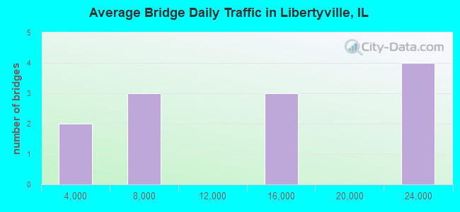
- 150,850Total average daily traffic
- 8,695Total average daily truck traffic
- National Bridge Inventory (NBI) Registered Bridges for Libertyville
- No street view available for this location
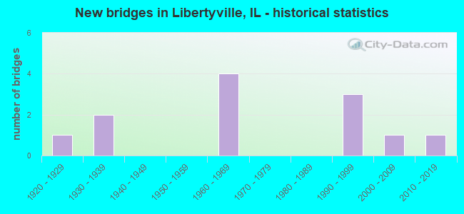
- New bridges - historical statistics
- 11920-1929
- 21930-1939
- 41960-1969
- 31990-1999
- 12000-2009
- 12010-2019
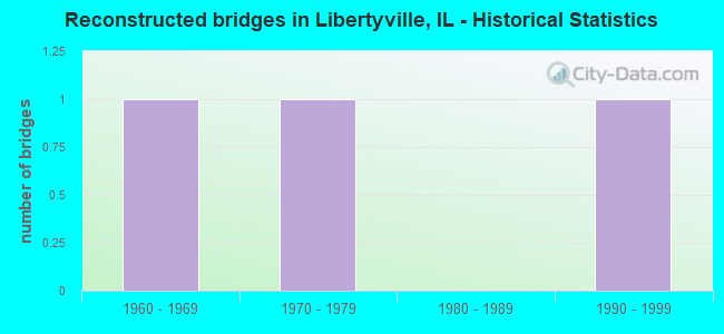
- Reconstructed bridges - Historical Statistics
- 11960-1969
- 11970-1979
- 01980-1989
- 11990-1999
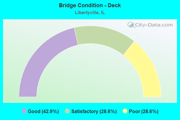
- Bridge Condition - Deck
- 42.9%Good
- 28.6%Satisfactory
- 28.6%Poor
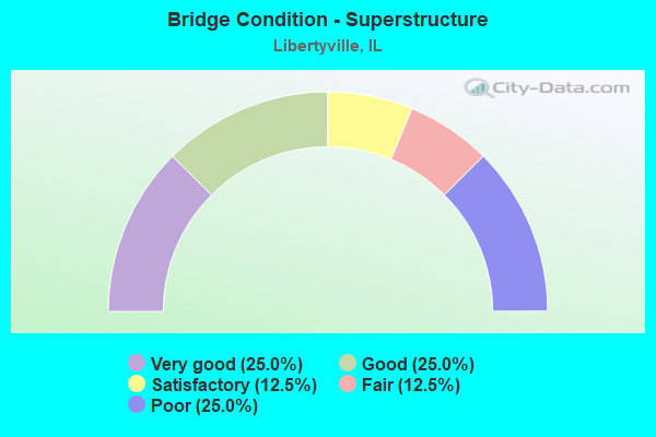
- Bridge Condition - Superstructure
- 25.0%Very good
- 25.0%Good
- 12.5%Satisfactory
- 12.5%Fair
- 25.0%Poor
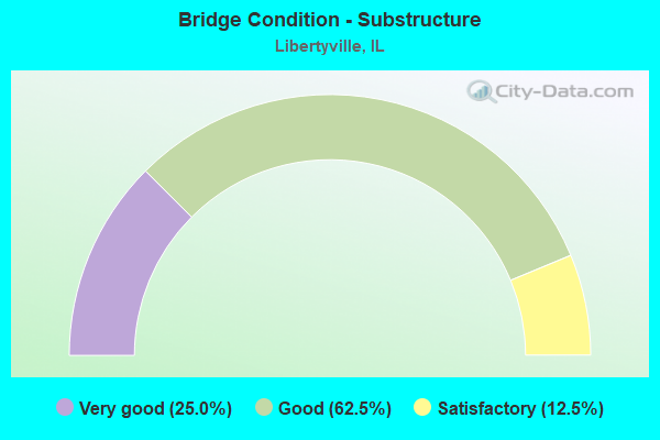
- Bridge Condition - Substructure
- 25.0%Very good
- 62.5%Good
- 12.5%Satisfactory
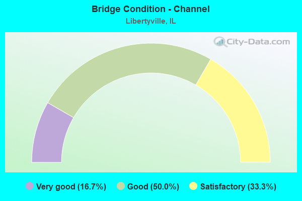
- Bridge Condition - Channel
- 16.7%Very good
- 50.0%Good
- 33.3%Satisfactory
Find on map >> Show street view
Structure Number: 490063, Location: 0.3 M E OF IL 21 (Lat: 42.305911, Lng: -87.955025), Route carried "on" structure: State highway 137, Year Built: 1933, Year Reconstructed: 1974, Status: Open, Structure Length: 4.75m (15.58ft), Average Daily Traffic: 20,600 (year 2021), Truck Traffic: 8%, Average Future Daily Traffic: 28,382 (year 2032), Design Load: HS 20+Mod, Features Intersected: DES PLAINES RIVER
Minimum Vertical Clearance: 30+ m (98+ ft), Kilometerpoint: 7.483, Lanes on structure: 4, Base Highway Network: Yes, Owner: State Highway Agency, Approaching Roadway Width: 18.3m (60.0ft), Skew: 22 degrees, Material/Design: Steel continuous, Design/Construction: Stringer/Multi-beam, Number Of Spans In Main Unit: 3, Length of Maximum Span: 15.2m (49.9ft), Curb or Sidewalk Widths: Left: 1.8m (5.9ft), Right: 1.8m (5.9ft), Curb-To-Curb Width: 16.5m (54.1ft), Out-to-Out Width: 20.7m (67.9ft)
Condition: Deck: Satisfactory, Superstructure: Good, Substructure: Good, Channel: Good, Operating Rating: 70.3 metric tons, Method Used To Determine Operating Rating: Load Factor (LF) rating reported by rating factor (RF) method using MS18 loading, Inventory Rating: 42.1 metric tons, Method Used To Determine Inventory Rating: Load Factor (LF) rating reported by rating factor (RF) method using MS18 loading, Structural Evaluation: Better than present minimum criteria, Deck Geometry: Meets minimum limits, Waterway Adequacy: Equal to present minimum criteria, Approach Roadway Alignment: Equal to present desirable criteria, Designated Inspection Frequency: Every 24 months, Inspection Date: October 2020, Deck Structure Type: Concrete Cast-file-Place, Wearing Surface/Protective System: Wearing Surface: Latex Concrete
Find on map >> Show street view
Structure Number: 490068, Location: 0.9 M E OF IL 21 (Lat: 42.281067, Lng: -87.934033), Route carried "on" structure: State highway 176, Year Built: 1925, Year Reconstructed: 1983, Status: Open, Structure Length: 4.39m (14.40ft), Average Daily Traffic: 12,800 (year 2021), Truck Traffic: 4%, Average Future Daily Traffic: 20,145 (year 2032), Design Load: HS 20, Features Intersected: DES PLAINES RIVER
Minimum Vertical Clearance: 30+ m (98+ ft), Kilometerpoint: 59.834, Lanes on structure: 2, Base Highway Network: Yes, Owner: State Highway Agency, Approaching Roadway Width: 11.6m (38.1ft), Material/Design: Steel continuous, Design/Construction: Stringer/Multi-beam, Number Of Spans In Main Unit: 3, Length of Maximum Span: 14.6m (47.9ft), Curb or Sidewalk Widths: Left: 0.0m, Right: 3.0m (9.8ft), Curb-To-Curb Width: 11.6m (38.1ft), Out-to-Out Width: 16.5m (54.1ft)
Condition: Deck: Satisfactory, Superstructure: Satisfactory, Substructure: Satisfactory, Channel: Good, Operating Rating: 74.5 metric tons, Method Used To Determine Operating Rating: Load Factor (LF) rating reported by rating factor (RF) method using MS18 loading, Inventory Rating: 44.7 metric tons, Method Used To Determine Inventory Rating: Load Factor (LF) rating reported by rating factor (RF) method using MS18 loading, Structural Evaluation: Equal to present minimum criteria, Deck Geometry: Somewhat better than minimum adequacy, Waterway Adequacy: Equal to present minimum criteria, Approach Roadway Alignment: Better than present minimum criteria, Length Of Structure Improvement: 5.27m (17.29ft), Designated Inspection Frequency: Every 24 months, Inspection Date: July 2021, Bridge Improvement Cost: $912,000, Roadway Improvement Cost: $91,000, Total Project Cost: $1,368,000, Deck Structure Type: Concrete Cast-file-Place, Wearing Surface/Protective System: Deck Protection: Epoxy Coated Reinforcing
Find on map >> Show street view
Structure Number: 490096, Location: 1.8 M W OF IL 21 (Lat: 42.305461, Lng: -87.990667), Route carried "on" structure: State highway 137, Year Built: 1966, Year Reconstructed: 2003, Status: Open, Structure Length: 5.85m (19.19ft), Average Daily Traffic: 13,100 (year 2021), Truck Traffic: 6%, Average Future Daily Traffic: 16,250 (year 2032), Design Load: HS 20, Features Intersected: IL 137 WB OFF RAMP
Minimum Vertical Clearance: 30+ m (98+ ft), Kilometerpoint: 4.474, Lanes on structure: 4, Lanes under structure: 1, Base Highway Network: Yes, Owner: State Highway Agency, Approaching Roadway Width: 20.7m (67.9ft), Skew: 35 degrees, Material/Design: Steel continuous, Design/Construction: Stringer/Multi-beam, Number Of Spans In Main Unit: 3, Length of Maximum Span: 21.9m (71.9ft), Curb-To-Curb Width: 20.7m (67.9ft), Out-to-Out Width: 22.9m (75.1ft)
Condition: Deck: Good, Superstructure: Good, Substructure: Good, Operating Rating: 89.1 metric tons, Method Used To Determine Operating Rating: Load Factor (LF) rating reported by rating factor (RF) method using MS18 loading, Inventory Rating: 74.8 metric tons, Method Used To Determine Inventory Rating: Load Factor (LF) rating reported by rating factor (RF) method using MS18 loading, Structural Evaluation: Better than present minimum criteria, Deck Geometry: Superior to present desirable criteria, Underclear: High priority of corrective action, Approach Roadway Alignment: Equal to present desirable criteria, Designated Inspection Frequency: Every 48 months, Inspection Date: April 2018, Deck Structure Type: Concrete Cast-file-Place, Wearing Surface/Protective System: Deck Protection: Epoxy Coated Reinforcing
Find on map >> Show street view
Structure Number: 49017, Location: 1.4 M S OF IL 120 (Lat: 42.314550, Lng: -88.004389), Route carried "on" structure: State highway 137, Year Built: 1993, Status: Open, Structure Length: 5.47m (17.95ft), Average Daily Traffic: 13,100 (year 2021), Truck Traffic: 6%, Average Future Daily Traffic: 15,693 (year 2032), Features Intersected: US 45
Minimum Vertical Clearance: 30+ m (98+ ft), Kilometerpoint: 2.929, Lanes on structure: 2, Lanes under structure: 4, Base Highway Network: Yes, Owner: State Highway Agency, Approaching Roadway Width: 18.3m (60.0ft), Skew: 5 degrees, Material/Design: Steel continuous, Design/Construction: Stringer/Multi-beam, Number Of Spans In Main Unit: 2, Length of Maximum Span: 27.4m (89.9ft), Curb-To-Curb Width: 18.0m (59.1ft), Out-to-Out Width: 19.3m (63.3ft)
Condition: Deck: Good, Superstructure: Fair, Substructure: Good, Operating Rating: 86.5 metric tons, Method Used To Determine Operating Rating: Load Factor (LF) rating reported by rating factor (RF) method using MS18 loading, Inventory Rating: 52.2 metric tons, Method Used To Determine Inventory Rating: Load Factor (LF) rating reported by rating factor (RF) method using MS18 loading, Structural Evaluation: Somewhat better than minimum adequacy, Deck Geometry: Superior to present desirable criteria, Underclear: High priority of corrective action, Approach Roadway Alignment: Better than present minimum criteria, Designated Inspection Frequency: Every 24 months, Inspection Date: March 2021, Deck Structure Type: Concrete Cast-file-Place, Wearing Surface/Protective System: Wearing Surface: Epoxy Overlay, Deck Protection: Epoxy Coated Reinforcing
Find on map >> Show street view
Structure Number: 490199, Location: 0.5 M N IL 137 (Lat: 42.311908, Lng: -87.963767), Route carried "on" structure: State highway 21, Year Built: 2012, Status: Open, Structure Length: 2.29m (7.51ft), Average Daily Traffic: 20,000 (year 2021), Truck Traffic: 4%, Average Future Daily Traffic: 26,489 (year 2032), Design Load: HS 25 or greater, Features Intersected: BULL CREEK
Minimum Vertical Clearance: 30+ m (98+ ft), Kilometerpoint: 35.839, Lanes on structure: 4, Base Highway Network: Yes, Owner: State Highway Agency, Approaching Roadway Width: 20.1m (65.9ft), Skew: 33 degrees, Material/Design: Steel, Design/Construction: Stringer/Multi-beam, Number Of Spans In Main Unit: 1, Length of Maximum Span: 20.6m (67.6ft), Curb or Sidewalk Widths: Left: 0.0m, Right: 2.4m (7.9ft), Curb-To-Curb Width: 20.1m (65.9ft), Out-to-Out Width: 24.7m (81.0ft)
Condition: Deck: Good, Superstructure: Very good, Substructure: Very good, Channel: Satisfactory, Operating Rating: 86.5 metric tons, Method Used To Determine Operating Rating: Load and Resistance Factor Rating (LRFR) rating reported by rating factor(RF) method using HL-93 loadings, Inventory Rating: 66.7 metric tons, Method Used To Determine Inventory Rating: Load and Resistance Factor Rating (LRFR) rating reported by rating factor(RF) method using HL-93 loadings, Structural Evaluation: Equal to present desirable criteria, Deck Geometry: Better than present minimum criteria, Waterway Adequacy: Equal to present desirable criteria, Approach Roadway Alignment: Equal to present desirable criteria, Designated Inspection Frequency: Every 48 months, Inspection Date: November 2019, Deck Structure Type: Concrete Cast-file-Place, Wearing Surface/Protective System: Deck Protection: Epoxy Coated Reinforcing
Find on map >> Show street view
Structure Number: 493047, Location: .75 M E OF ILL 21 (Lat: 42.288847, Lng: -87.937486), Route carried "on" structure: Other road , Year Built: 1967, Status: Open, Structure Length: 5.30m (17.39ft), Average Daily Traffic: 3,550 (year 2019), Truck Traffic: 4%, Average Future Daily Traffic: 3,116 (year 2032), Design Load: HS 20, Features Intersected: DES PLAINES RIVER, Facility Carried by Structure: FAU-1234 (OAK SP R
Minimum Vertical Clearance: 30+ m (98+ ft), Kilometerpoint: 1.561, Lanes on structure: 2, Owner: Town or Township Highway Agency, Approaching Roadway Width: 10.4m (34.1ft), Material/Design: Concrete continuous, Design/Construction: Tee Beam, Number Of Spans In Main Unit: 4, Length of Maximum Span: 15.2m (49.9ft), Curb or Sidewalk Widths: Left: 1.1m (3.6ft), Right: 1.1m (3.6ft), Curb-To-Curb Width: 9.1m (29.9ft), Out-to-Out Width: 11.6m (38.1ft)
Condition: Deck: Poor, Superstructure: Poor, Substructure: Good, Channel: Good, Operating Rating: 52.8 metric tons, Method Used To Determine Operating Rating: Load Factor (LF) rating reported by rating factor (RF) method using MS18 loading, Inventory Rating: 32.4 metric tons, Method Used To Determine Inventory Rating: Load Factor (LF) rating reported by rating factor (RF) method using MS18 loading, Structural Evaluation: Meets minimum limits, Deck Geometry: Meets minimum limits, Waterway Adequacy: Equal to present desirable criteria, Approach Roadway Alignment: Equal to present desirable criteria, Designated Inspection Frequency: Every 24 months, Inspection Date: May 2020, Deck Structure Type: Concrete Cast-file-Place, Wearing Surface/Protective System: Wearing Surface: Bituminous
Find on map >> Show street view
Structure Number: 493048, Location: 1.5 MI W I-94 (Lat: 42.276650, Lng: -87.939303), Route carried "on" structure: Other road , Year Built: 1990, Status: Open, Structure Length: 4.74m (15.55ft), Average Daily Traffic: 5,050 (year 2019), Truck Traffic: 2%, Average Future Daily Traffic: 6,344 (year 2032), Design Load: HS 20, Features Intersected: DesPlaines River, Facility Carried by Structure: FAU-1239 Rockland
Minimum Vertical Clearance: 30+ m (98+ ft), Kilometerpoint: 2.993, Lanes on structure: 2, Owner: City or Municipal Highway Agency, Approaching Roadway Width: 9.1m (29.9ft), Material/Design: Prestressed concrete, Design/Construction: Box Beam or Girders - Multiple, Number Of Spans In Main Unit: 3, Length of Maximum Span: 15.0m (49.2ft), Curb or Sidewalk Widths: Left: 0.0m, Right: 1.3m (4.3ft), Curb-To-Curb Width: 9.1m (29.9ft), Out-to-Out Width: 10.1m (33.1ft)
Condition: Deck: Poor, Superstructure: Poor, Substructure: Good, Channel: Satisfactory, Operating Rating: 58.3 metric tons, Method Used To Determine Operating Rating: Load Factor (LF) rating reported by rating factor (RF) method using MS18 loading, Inventory Rating: 34.3 metric tons, Method Used To Determine Inventory Rating: Load Factor (LF) rating reported by rating factor (RF) method using MS18 loading, Structural Evaluation: Meets minimum limits, Deck Geometry: High priority of corrective action, Waterway Adequacy: Equal to present desirable criteria, Approach Roadway Alignment: Equal to present desirable criteria, Length Of Structure Improvement: 5.70m (18.70ft), Designated Inspection Frequency: Every 24 months, Inspection Date: May 2021, Bridge Improvement Cost: $553,000, Roadway Improvement Cost: $55,000, Total Project Cost: $830,000, Deck Structure Type: Concrete Precast Panels, Wearing Surface/Protective System: Wearing Surface: Bituminous
Find on map >> Show street view
Structure Number: 497001, Location: 3000FT W of IL 21 (Lat: 42.290350, Lng: -87.965344), Route carried "on" structure: Other road , Year Built: 2008, Status: Open, Structure Length: 0.91m (2.99ft), Average Daily Traffic: 3,150 (year 2019), Truck Traffic: 4%, Average Future Daily Traffic: 2,920 (year 2043), Design Load: HS 25 or greater, Features Intersected: Bull Creek, Facility Carried by Structure: Lake Street
Minimum Vertical Clearance: 30+ m (98+ ft), Kilometerpoint: 1.561, Lanes on structure: 2, Owner: City or Municipal Highway Agency, Approaching Roadway Width: 7.3m (24.0ft), Material/Design: Concrete, Design/Construction: Frame, Number Of Spans In Main Unit: 1, Length of Maximum Span: 8.8m (28.9ft), Curb or Sidewalk Widths: Left: 1.8m (5.9ft), Right: 2.3m (7.5ft), Curb-To-Curb Width: 8.2m (26.9ft)
Condition: Superstructure: Very good, Substructure: Very good, Channel: Very good, Operating Rating: 42.1 metric tons, Method Used To Determine Operating Rating: Assigned ratings based on Load and Resistance Factor Design (LRFD) reported by rating factor (RF) using HL93 loadings, Inventory Rating: 32.4 metric tons, Method Used To Determine Inventory Rating: Assigned ratings based on Load and Resistance Factor Design (LRFD) reported by rating factor (RF) using HL93 loadings, Structural Evaluation: Equal to present desirable criteria, Deck Geometry: High priority of corrective action, Waterway Adequacy: Equal to present desirable criteria, Approach Roadway Alignment: Equal to present desirable criteria, Designated Inspection Frequency: Every 48 months, Inspection Date: May 2021, Deck Structure Type: Other
Find on map >> Show street view
Structure Number: 490096, Location: 1.8 M W OF IL 21 (Lat: 42.305728, Lng: -87.990417), Route carried "under" structure: Other road , Year Built: 1966, Structure Length: 0. m, Average Daily Traffic: 7,800 (year 2019), Truck Traffic: 12%, Features Intersected: IL 137 WB OFF RAMP, Facility Carried by Structure: IL 137
Minimum Vertical Clearance: 4.39m (14.40ft), Kilometerpoint: 0.483, Lanes on structure: 4, Lanes under structure: 1, Material/Design: Steel continuous, Design/Construction: Stringer/Multi-beam, Length of Maximum Span: 21.9m (71.9ft)
Find on map >> Show street view
Structure Number: 490102, Location: .03M S OF ILL 137 (Lat: 42.314203, Lng: -88.004486), Route carried "under" structure: US 45, Year Built: 1939, Structure Length: 0. m, Average Daily Traffic: 21,900 (year 2021), Truck Traffic: 4%, Features Intersected: US 45, Facility Carried by Structure: CM & STP RR
Minimum Vertical Clearance: 4.32m (14.17ft), Kilometerpoint: 663.595, Lanes under structure: 4, Material/Design: Steel, Design/Construction: Girder and Floorbeam System, Length of Maximum Span: 8.5m (27.9ft)
Find on map >> Show street view
Structure Number: 490127, Location: 0.55 M E OF US 45 (Lat: 42.305000, Lng: -87.992619), Route carried "under" structure: Other road , Year Built: 1967, Structure Length: 0. m, Average Daily Traffic: 7,900 (year 2019), Truck Traffic: 14%, Features Intersected: PETERSON AVE, Facility Carried by Structure: RR - METRA
Minimum Vertical Clearance: 5.03m (16.50ft), Kilometerpoint: 0.000, Lanes under structure: 2, Material/Design: Steel, Design/Construction: Stringer/Multi-beam, Length of Maximum Span: 16.5m (54.1ft)
Find on map >> Show street view
Structure Number: 49017, Location: 1.4 M S OF IL 120 (Lat: 42.314639, Lng: -88.004486), Route carried "under" structure: US 45, Year Built: 1993, Structure Length: 0. m, Average Daily Traffic: 21,900 (year 2021), Truck Traffic: 4%, Features Intersected: US 45, Facility Carried by Structure: IL 137
Minimum Vertical Clearance: 4.62m (15.16ft), Kilometerpoint: 663.643, Lanes on structure: 2, Lanes under structure: 4, Material/Design: Steel continuous, Design/Construction: Stringer/Multi-beam, Length of Maximum Span: 27.4m (89.9ft)