Bridge Statistics for Lima, Montana (MT)
Condition, Traffic, Stress, Structural Evaluation, Project Costs
- National Bridge Inventory (NBI) Statistics
- 13Number of bridges
- 164ft / 50.0mTotal length
- $1,431,000Total costs
- 21,592Total average daily traffic
- 5,705Total average daily truck traffic
- National Bridge Inventory (NBI) Registered Bridges for Lima
- No street view available for this location
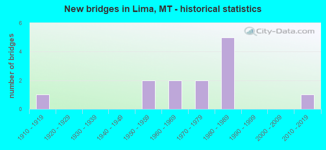
- New bridges - historical statistics
- 11910-1919
- 21950-1959
- 21960-1969
- 21970-1979
- 51980-1989
- 12010-2019


- Bridge Condition - Deck
- 25.0%Good
- 37.5%Satisfactory
- 37.5%Fair

- Bridge Condition - Superstructure
- 62.5%Good
- 37.5%Satisfactory

- Bridge Condition - Substructure
- 50.0%Good
- 25.0%Satisfactory
- 25.0%Fair

- Bridge Condition - Channel
- 33.3%Very good
- 33.3%Good
- 33.3%Satisfactory
Find on map >> Show street view
Structure Number: 101, Location: 1.9M S LIMA (Lat: 44.617483, Lng: -112.551522), Route carried "on" structure: Interstate 15, Year Built: 2016, Status: Open, Structure Length: 17.08m (56.04ft), Average Daily Traffic: 2,879 (year 2020), Truck Traffic: 32%, Average Future Daily Traffic: 3,023 (year 2040), Design Load: HL 93, Features Intersected: SEP RR
Minimum Vertical Clearance: 30+ m (98+ ft), Kilometerpoint: 20.653, Lanes on structure: 2, Base Highway Network: Yes, Owner: State Highway Agency, Approaching Roadway Width: 11.6m (38.1ft), Material/Design: Steel continuous, Design/Construction: Stringer/Multi-beam, Number Of Spans In Main Unit: 5, Length of Maximum Span: 40.9m (134.2ft), Curb-To-Curb Width: 11.5m (37.7ft), Out-to-Out Width: 12.2m (40.0ft)
Condition: Deck: Good, Superstructure: Good, Substructure: Good, Operating Rating: 46.3 metric tons, Method Used To Determine Operating Rating: Load and Resistance Factor (LRFR), Inventory Rating: 36.3 metric tons, Method Used To Determine Inventory Rating: Load and Resistance Factor (LRFR), Structural Evaluation: Better than present minimum criteria, Deck Geometry: Somewhat better than minimum adequacy, Underclear: Somewhat better than minimum adequacy, Approach Roadway Alignment: Equal to present desirable criteria, Length Of Structure Improvement: 17.07m (56.00ft), Designated Inspection Frequency: Every 24 months, Critical Feature Inspection Frequency: Every 24 months, Inspection Date: July 2021, Critical Feature Inspection Date: July 2021, Bridge Improvement Cost: $856,000, Roadway Improvement Cost: $428,000, Total Project Cost: $1,284,000, Deck Structure Type: Concrete Cast-file-Place
Find on map >> Show street view
Structure Number: 201907091, Location: 5M S ELLISTON (Lat: 46.504378, Lng: -112.403694), Route carried "on" structure: County highway 39005, Year Built: 1981, Status: Open, Structure Length: 2.07m (6.79ft), Average Daily Traffic: 100 (year 2022), Truck Traffic: 3%, Average Future Daily Traffic: 100 (year 2037), Features Intersected: LITTLE BLACKFOOT RIVER, Facility Carried by Structure: LITTLE BLACKFOOT R
Minimum Vertical Clearance: 30+ m (98+ ft), Kilometerpoint: 2.162, Lanes on structure: 1, Owner: County Highway Agency, Approaching Roadway Width: 5.8m (19.0ft), Material/Design: Concrete, Design/Construction: Tee Beam, Number Of Spans In Main Unit: 1, Length of Maximum Span: 18.9m (62.0ft), Curb-To-Curb Width: 4.3m (14.1ft), Out-to-Out Width: 5.1m (16.7ft)
Condition: Deck: Good, Superstructure: Good, Substructure: Good, Channel: Good, Deck Geometry: Equal to present minimum criteria, Waterway Adequacy: Equal to present desirable criteria, Approach Roadway Alignment: Equal to present minimum criteria, Designated Inspection Frequency: Every 24 months, Inspection Date: May 2021, Deck Structure Type: Other
Find on map >> Show street view
Structure Number: 201907096, Location: LIMA (Lat: 44.634075, Lng: -112.587247), Route carried "on" structure: City street 17410, Year Built: 1988, Status: Open, Structure Length: 0.66m (2.17ft), Average Daily Traffic: 178 (year 2020), Truck Traffic: 3%, Average Future Daily Traffic: 187 (year 2040), Features Intersected: JUNCTION CREEK, Facility Carried by Structure: BAILEY ST
Minimum Vertical Clearance: 30+ m (98+ ft), Kilometerpoint: 0.322, Lanes on structure: 2, Owner: County Highway Agency, Approaching Roadway Width: 7.3m (24.0ft), Material/Design: Concrete, Design/Construction: Culvert, Number Of Spans In Main Unit: 1, Length of Maximum Span: 6.1m (20.0ft), Curb or Sidewalk Widths: Left: 0.3m (1.0ft), Right: 0.3m (1.0ft), Curb-To-Curb Width: 10.2m (33.5ft), Out-to-Out Width: 10.8m (35.4ft)
Condition: Channel: Very good, Culverts: Good, Deck Geometry: Better than present minimum criteria, Waterway Adequacy: Equal to present desirable criteria, Approach Roadway Alignment: Equal to present minimum criteria, Bridge Posting: Required (Relationship of Operating Rating to Maximum Legal Load: > 39.9% below), Designated Inspection Frequency: Every 24 months, Inspection Date: July 2021
Find on map >> Show street view
Structure Number: I00015012+07671, Location: 1.9M S LIMA (Lat: 44.617672, Lng: -112.552092), Route carried "on" structure: Interstate 15, Year Built: 1980, Status: Open, Structure Length: 14.66m (48.10ft), Average Daily Traffic: 2,879 (year 2020), Truck Traffic: 32%, Average Future Daily Traffic: 3,023 (year 2040), Design Load: HS 20, Features Intersected: SEP RR
Minimum Vertical Clearance: 30+ m (98+ ft), Kilometerpoint: 20.713, Lanes on structure: 2, Base Highway Network: Yes, Owner: State Highway Agency, Approaching Roadway Width: 12.8m (42.0ft), Material/Design: Steel, Design/Construction: Stringer/Multi-beam, Number Of Spans In Main Unit: 2, Number Of Approach Spans: 5, Length of Maximum Span: 30.5m (100.1ft), Curb-To-Curb Width: 12.6m (41.3ft), Out-to-Out Width: 13.5m (44.3ft)
Condition: Deck: Satisfactory, Superstructure: Satisfactory, Substructure: Satisfactory, Operating Rating: 48.1 metric tons, Method Used To Determine Operating Rating: Load and Resistance Factor (LRFR), Inventory Rating: 37.2 metric tons, Method Used To Determine Inventory Rating: Load and Resistance Factor (LRFR), Structural Evaluation: Equal to present minimum criteria, Deck Geometry: Better than present minimum criteria, Underclear: Equal to present minimum criteria, Approach Roadway Alignment: Equal to present desirable criteria, Designated Inspection Frequency: Every 24 months, Critical Feature Inspection Frequency: Every 24 months, Other Special Inspection Frequency: Every 48 months, Inspection Date: October 2020, Critical Feature Inspection Date: October 2020, Other Special Inspection Date: April 2021, Deck Structure Type: Concrete Cast-file-Place
Find on map >> Show street view
Structure Number: I00015015+01701, Location: LIMA (Lat: 44.632025, Lng: -112.592667), Route carried "on" structure: Interstate 15, Year Built: 1959, Status: Open, Structure Length: 3.63m (11.91ft), Average Daily Traffic: 3,028 (year 2020), Truck Traffic: 31%, Average Future Daily Traffic: 3,179 (year 2040), Design Load: HS 20, Features Intersected: INT LIMA-BAILEY ST
Minimum Vertical Clearance: 30+ m (98+ ft), Kilometerpoint: 24.437, Lanes on structure: 2, Lanes under structure: 2, Base Highway Network: Yes, Owner: State Highway Agency, Approaching Roadway Width: 12.8m (42.0ft), Material/Design: Prestressed concrete, Design/Construction: Stringer/Multi-beam, Number Of Spans In Main Unit: 3, Length of Maximum Span: 14.2m (46.6ft), Curb-To-Curb Width: 13.4m (44.0ft), Out-to-Out Width: 14.5m (47.6ft)
Condition: Deck: Satisfactory, Superstructure: Satisfactory, Substructure: Good, Operating Rating: 61.2 metric tons, Method Used To Determine Operating Rating: Load Factor (LF), Inventory Rating: 38.6 metric tons, Method Used To Determine Inventory Rating: Load Factor (LF), Structural Evaluation: Equal to present minimum criteria, Deck Geometry: Superior to present desirable criteria, Underclear: Somewhat better than minimum adequacy, Approach Roadway Alignment: Equal to present desirable criteria, Designated Inspection Frequency: Every 48 months, Inspection Date: January 2021, Deck Structure Type: Concrete Cast-file-Place, Wearing Surface/Protective System: Wearing Surface: Bituminous
Find on map >> Show street view
Structure Number: I00015015+01702, Location: LIMA (Lat: 44.631894, Lng: -112.592839), Route carried "on" structure: Interstate 15, Year Built: 1980, Status: Open, Structure Length: 3.63m (11.91ft), Average Daily Traffic: 3,028 (year 2020), Truck Traffic: 31%, Average Future Daily Traffic: 3,179 (year 2040), Design Load: HS 20, Features Intersected: INT LIMA-BAILEY ST
Minimum Vertical Clearance: 30+ m (98+ ft), Kilometerpoint: 24.442, Lanes on structure: 2, Lanes under structure: 2, Base Highway Network: Yes, Owner: State Highway Agency, Approaching Roadway Width: 12.8m (42.0ft), Material/Design: Prestressed concrete, Design/Construction: Stringer/Multi-beam, Number Of Spans In Main Unit: 3, Length of Maximum Span: 14.2m (46.6ft), Curb-To-Curb Width: 12.6m (41.3ft), Out-to-Out Width: 13.4m (44.0ft)
Condition: Deck: Satisfactory, Superstructure: Good, Substructure: Good, Operating Rating: 63.1 metric tons, Method Used To Determine Operating Rating: Load Factor (LF), Inventory Rating: 37.7 metric tons, Method Used To Determine Inventory Rating: Load Factor (LF), Structural Evaluation: Better than present minimum criteria, Deck Geometry: Better than present minimum criteria, Underclear: Somewhat better than minimum adequacy, Approach Roadway Alignment: Equal to present desirable criteria, Designated Inspection Frequency: Every 48 months, Inspection Date: January 2021, Deck Structure Type: Concrete Cast-file-Place, Wearing Surface/Protective System: Wearing Surface: Monolithic Concrete
Find on map >> Show street view
Structure Number: I00015019+08071, Location: 3.7M S DELL (Lat: 44.683208, Lng: -112.648422), Route carried "on" structure: Interstate 15, Year Built: 1967, Status: Open, Structure Length: 3.29m (10.79ft), Average Daily Traffic: 3,028 (year 2020), Truck Traffic: 31%, Average Future Daily Traffic: 3,179 (year 2040), Design Load: HS 20, Features Intersected: SEP GOSMAN LANE
Minimum Vertical Clearance: 30+ m (98+ ft), Kilometerpoint: 31.883, Lanes on structure: 2, Lanes under structure: 2, Base Highway Network: Yes, Owner: State Highway Agency, Approaching Roadway Width: 15.2m (49.9ft), Material/Design: Prestressed concrete, Design/Construction: Stringer/Multi-beam, Number Of Spans In Main Unit: 3, Length of Maximum Span: 14.3m (46.9ft), Curb-To-Curb Width: 13.4m (44.0ft), Out-to-Out Width: 14.3m (46.9ft)
Condition: Deck: Fair, Superstructure: Good, Substructure: Fair, Operating Rating: 52.6 metric tons, Method Used To Determine Operating Rating: Load and Resistance Factor (LRFR), Inventory Rating: 40.8 metric tons, Method Used To Determine Inventory Rating: Load and Resistance Factor (LRFR), Structural Evaluation: Somewhat better than minimum adequacy, Deck Geometry: Superior to present desirable criteria, Underclear: Meets minimum limits, Approach Roadway Alignment: Equal to present desirable criteria, Designated Inspection Frequency: Every 24 months, Inspection Date: September 2021, Deck Structure Type: Concrete Cast-file-Place
Find on map >> Show street view
Structure Number: I00015019+08072, Location: 3.7M S DELL (Lat: 44.683061, Lng: -112.648681), Route carried "on" structure: Interstate 15, Year Built: 1971, Status: Open, Structure Length: 3.29m (10.79ft), Average Daily Traffic: 3,028 (year 2020), Truck Traffic: 31%, Average Future Daily Traffic: 3,179 (year 2040), Design Load: HS 20, Features Intersected: SEP GOSMAN LANE
Minimum Vertical Clearance: 30+ m (98+ ft), Kilometerpoint: 31.890, Lanes on structure: 2, Lanes under structure: 2, Base Highway Network: Yes, Owner: State Highway Agency, Approaching Roadway Width: 15.2m (49.9ft), Material/Design: Prestressed concrete, Design/Construction: Stringer/Multi-beam, Number Of Spans In Main Unit: 3, Length of Maximum Span: 14.2m (46.6ft), Curb-To-Curb Width: 12.6m (41.3ft), Out-to-Out Width: 13.5m (44.3ft)
Condition: Deck: Fair, Superstructure: Good, Substructure: Satisfactory, Operating Rating: 51.7 metric tons, Method Used To Determine Operating Rating: Load and Resistance Factor (LRFR), Inventory Rating: 39.0 metric tons, Method Used To Determine Inventory Rating: Load and Resistance Factor (LRFR), Structural Evaluation: Equal to present minimum criteria, Deck Geometry: Better than present minimum criteria, Underclear: Meets minimum limits, Approach Roadway Alignment: Equal to present desirable criteria, Designated Inspection Frequency: Every 24 months, Inspection Date: September 2021, Deck Structure Type: Concrete Cast-file-Place
Find on map >> Show street view
Structure Number: L01266000+05001, Location: 4M NW LIMA (Lat: 44.675375, Lng: -112.623783), Route carried "on" structure: County highway 1266, Year Built: 1915, Status: Posted for load, Structure Length: 1.71m (5.61ft), Average Daily Traffic: 40 (year 2020), Truck Traffic: 3%, Average Future Daily Traffic: 42 (year 2040), Features Intersected: RED ROCK RIVER 084, Facility Carried by Structure: STEEL BRIDGE LN
Minimum Vertical Clearance: 30+ m (98+ ft), Kilometerpoint: 0.844, Lanes on structure: 1, Owner: County Highway Agency, Approaching Roadway Width: 4.6m (15.1ft), Material/Design: Steel, Design/Construction: Truss - Thru, Number Of Spans In Main Unit: 1, Length of Maximum Span: 17.1m (56.1ft), Curb-To-Curb Width: 4.7m (15.4ft), Out-to-Out Width: 4.9m (16.1ft)
Condition: Deck: Fair, Superstructure: Satisfactory, Substructure: Fair, Channel: Satisfactory, Operating Rating: 9.1 metric tons, Method Used To Determine Operating Rating: Load and Resistance Factor (LRFR), Inventory Rating: 6.4 metric tons, Method Used To Determine Inventory Rating: Load and Resistance Factor (LRFR), Structural Evaluation: High priority of replacement, Deck Geometry: Better than present minimum criteria, Waterway Adequacy: Better than present minimum criteria, Approach Roadway Alignment: Equal to present desirable criteria, Bridge Posting: Required (Relationship of Operating Rating to Maximum Legal Load: > 39.9% below), Length Of Structure Improvement: 2.40m (7.87ft), Designated Inspection Frequency: Every 24 months, Critical Feature Inspection Frequency: Every 24 months, Inspection Date: November 2020, Critical Feature Inspection Date: November 2020, Bridge Improvement Cost: $98,000, Roadway Improvement Cost: $49,000, Total Project Cost: $147,000, Deck Structure Type: Wood or Timber, Wearing Surface/Protective System: Wearing Surface: Wood or Timber
Find on map >> Show street view
Structure Number: I00015015+01701, Location: LIMA (Lat: 44.632025, Lng: -112.592667), Route carried "under" structure: ServiceState highway 1309, Year Built: 1959, Structure Length: 0. m, Average Daily Traffic: 1,602 (year 2020), Truck Traffic: 3%, Features Intersected: INT LIMA-BAILEY ST, Facility Carried by Structure: I 15
Minimum Vertical Clearance: 4.60m (15.09ft), Kilometerpoint: 0.100, Lanes on structure: 2, Lanes under structure: 2, Material/Design: Prestressed concrete, Design/Construction: Stringer/Multi-beam, Length of Maximum Span: 14.2m (46.6ft)
Find on map >> Show street view
Structure Number: I00015015+01702, Location: LIMA (Lat: 44.631894, Lng: -112.592839), Route carried "under" structure: ServiceState highway 1309, Year Built: 1980, Structure Length: 0. m, Average Daily Traffic: 1,602 (year 2020), Truck Traffic: 3%, Features Intersected: INT LIMA-BAILEY ST, Facility Carried by Structure: I 15
Minimum Vertical Clearance: 4.60m (15.09ft), Kilometerpoint: 0.080, Lanes on structure: 2, Lanes under structure: 2, Material/Design: Prestressed concrete, Design/Construction: Stringer/Multi-beam, Length of Maximum Span: 14.2m (46.6ft)
Find on map >> Show street view
Structure Number: I00015019+08071, Location: 37M S DELL (Lat: 44.683208, Lng: -112.648422), Route carried "under" structure: ServiceState highway 1232, Year Built: 1967, Structure Length: 0. m, Average Daily Traffic: 100 (year 2022), Truck Traffic: 3%, Features Intersected: SEP GOSMAN LANE, Facility Carried by Structure: I 15
Minimum Vertical Clearance: 4.57m (14.99ft), Kilometerpoint: 0.062, Lanes on structure: 2, Lanes under structure: 2, Material/Design: Prestressed concrete, Design/Construction: Stringer/Multi-beam, Length of Maximum Span: 14.3m (46.9ft)
Find on map >> Show street view
Structure Number: I00015019+08072, Location: 37M S DELL (Lat: 44.683061, Lng: -112.648681), Route carried "under" structure: ServiceState highway 1000, Year Built: 1971, Structure Length: 0. m, Average Daily Traffic: 100 (year 2022), Truck Traffic: 3%, Features Intersected: SEP GOSMAN LANE, Facility Carried by Structure: I 15
Minimum Vertical Clearance: 4.45m (14.60ft), Kilometerpoint: 0.085, Lanes on structure: 2, Lanes under structure: 2, Material/Design: Prestressed concrete, Design/Construction: Stringer/Multi-beam, Length of Maximum Span: 14.2m (46.6ft)