Bridge Statistics for Lindale, Georgia (GA)
Condition, Traffic, Stress, Structural Evaluation, Project Costs
- National Bridge Inventory (NBI) Statistics
- 30Number of bridges
- 295ft / 89.8mTotal length
- $18,547,000Total costs
- 182,400Total average daily traffic
- 5,473Total average daily truck traffic
- National Bridge Inventory (NBI) Registered Bridges for Lindale
- No street view available for this location
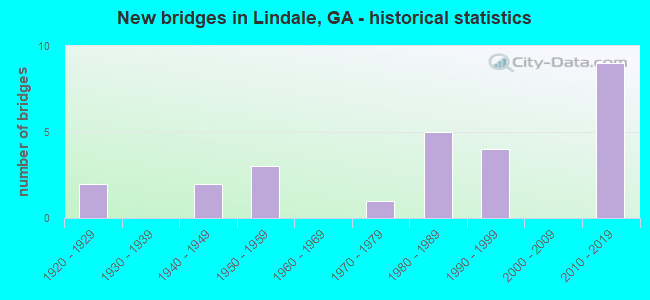
- New bridges - historical statistics
- 21920-1929
- 21940-1949
- 31950-1959
- 11970-1979
- 51980-1989
- 41990-1999
- 92010-2019

- Reconstructed bridges - Historical Statistics
- 11950-1959
- 01960-1969
- 01970-1979
- 11980-1989
- 11990-1999


- Bridge Condition - Deck
- 73.3%Good
- 13.3%Satisfactory
- 13.3%Fair

- Bridge Condition - Superstructure
- 20.0%Very good
- 40.0%Good
- 26.7%Satisfactory
- 13.3%Fair

- Bridge Condition - Substructure
- 73.3%Good
- 20.0%Satisfactory
- 6.7%Fair

- Bridge Condition - Channel
- 4.8%Excellent
- 61.9%Very good
- 19.0%Good
- 9.5%Satisfactory
- 4.8%Fair

- Bridge Condition - Culverts
- 72.7%Good
- 27.3%Satisfactory
Find on map >> Show street view
Structure Number: 115002, Location: 2.7 MI SE OF HOMER (Lat: 34.317708, Lng: -83.455769), Route carried "on" structure: County highway 6, Year Built: 1959, Status: Posted for load, Structure Length: 1.71m (5.61ft), Average Daily Traffic: 50 (year 2012), Truck Traffic: 1%, Average Future Daily Traffic: 75 (year 2032), Features Intersected: WEBB CREEK, Facility Carried by Structure: MARSHBURNS ROAD
Minimum Vertical Clearance: 30+ m (98+ ft), Kilometerpoint: 3.219, Lanes on structure: 1, Base Highway Network: Yes, Owner: County Highway Agency, Approaching Roadway Width: 4.3m (14.1ft), Skew: 1 degrees, Material/Design: Steel continuous, Design/Construction: Stringer/Multi-beam, Number Of Spans In Main Unit: 2, Length of Maximum Span: 8.5m (27.9ft), Curb-To-Curb Width: 4.0m (13.1ft), Out-to-Out Width: 4.4m (14.4ft)
Condition: Deck: Good, Superstructure: Satisfactory, Substructure: Satisfactory, Channel: Good, Operating Rating: 35.3 metric tons, Method Used To Determine Operating Rating: Load Factor (LF), Inventory Rating: 17.2 metric tons, Method Used To Determine Inventory Rating: Load Factor (LF), Structural Evaluation: Somewhat better than minimum adequacy, Deck Geometry: Somewhat better than minimum adequacy, Waterway Adequacy: Better than present minimum criteria, Approach Roadway Alignment: Equal to present minimum criteria, Bridge Posting: Required (Relationship of Operating Rating to Maximum Legal Load: 0.1 - 9.9% below), Length Of Structure Improvement: 42.09m (138.09ft), Designated Inspection Frequency: Every 24 months, Inspection Date: August 2021, Bridge Improvement Cost: $159,000, Roadway Improvement Cost: $16,000, Total Project Cost: $239,000, Deck Structure Type: Wood or Timber, Wearing Surface/Protective System: Wearing Surface: Wood or Timber
Find on map >> Show street view
Structure Number: 115008, Location: 3.2 MI SW OF HOMER (Lat: 34.307439, Lng: -83.543450), Route carried "on" structure: County highway 37, Year Built: 1970, Status: Posted for load, Structure Length: 1.77m (5.81ft), Average Daily Traffic: 30 (year 2012), Truck Traffic: 1%, Average Future Daily Traffic: 45 (year 2032), Features Intersected: HICKORY LEVEL CREEK, Facility Carried by Structure: HICKORY CREEK ROAD
Minimum Vertical Clearance: 30+ m (98+ ft), Kilometerpoint: 1.609, Lanes on structure: 1, Base Highway Network: Yes, Owner: County Highway Agency, Approaching Roadway Width: 4.9m (16.1ft), Material/Design: Steel continuous, Design/Construction: Stringer/Multi-beam, Number Of Spans In Main Unit: 4, Length of Maximum Span: 5.8m (19.0ft), Curb-To-Curb Width: 2.9m (9.5ft), Out-to-Out Width: 4.4m (14.4ft)
Condition: Deck: Good, Superstructure: Satisfactory, Substructure: Good, Channel: Fair, Operating Rating: 31.7 metric tons, Method Used To Determine Operating Rating: Load Factor (LF), Inventory Rating: 19.0 metric tons, Method Used To Determine Inventory Rating: Load Factor (LF), Structural Evaluation: Somewhat better than minimum adequacy, Deck Geometry: High priority of replacement, Waterway Adequacy: Equal to present desirable criteria, Approach Roadway Alignment: Equal to present minimum criteria, Bridge Posting: Required (Relationship of Operating Rating to Maximum Legal Load: 10.0 - 19.9% below), Length Of Structure Improvement: 42.00m (137.80ft), Designated Inspection Frequency: Every 24 months, Inspection Date: August 2021, Bridge Improvement Cost: $165,000, Roadway Improvement Cost: $16,000, Total Project Cost: $247,000, Deck Structure Type: Wood or Timber, Wearing Surface/Protective System: Wearing Surface: Wood or Timber
Find on map >> Show street view
Structure Number: 1150001, Location: 7.6 MI S OF ROME (Lat: 34.147197, Lng: -85.218492), Route carried "on" structure: US 27, Year Built: 1948, Year Reconstructed: 1997, Status: Open, Structure Length: 1.10m (3.61ft), Average Daily Traffic: 11,500 (year 2012), Truck Traffic: 8%, Average Future Daily Traffic: 17,250 (year 2032), Design Load: H 15, Features Intersected: PRENTIS CREEK
Minimum Vertical Clearance: 30+ m (98+ ft), Kilometerpoint: 6.437, Lanes on structure: 4, Base Highway Network: Yes, Owner: State Highway Agency, Approaching Roadway Width: 18.3m (60.0ft), Skew: 29 degrees, Material/Design: Concrete, Design/Construction: Culvert, Number Of Spans In Main Unit: 3, Length of Maximum Span: 3.4m (11.2ft)
Condition: Channel: Very good, Culverts: Good, Operating Rating: 70.7 metric tons, Method Used To Determine Operating Rating: Load Factor (LF), Inventory Rating: 42.6 metric tons, Method Used To Determine Inventory Rating: Load Factor (LF), Structural Evaluation: Better than present minimum criteria, Waterway Adequacy: Superior to present desirable criteria, Approach Roadway Alignment: Equal to present desirable criteria, Designated Inspection Frequency: Every 24 months, Inspection Date: September 2021, Bridge Improvement Cost: $217,000, Roadway Improvement Cost: $22,000, Total Project Cost: $326,000
Find on map >> Show street view
Structure Number: 1150003, Location: 6 MI S OF ROME @ SR 53 (Lat: 34.177750, Lng: -85.206439), Route carried "on" structure: US 27, Year Built: 1981, Year Reconstructed: 1991, Status: Open, Structure Length: 5.49m (18.01ft), Average Daily Traffic: 18,710 (year 2012), Truck Traffic: 7%, Average Future Daily Traffic: 28,065 (year 2032), Design Load: HS 20+Mod, Features Intersected: SOU R/R (ABANDONED)
Minimum Vertical Clearance: 30+ m (98+ ft), Kilometerpoint: 9.656, Lanes on structure: 5, Base Highway Network: Yes, Owner: State Highway Agency, Approaching Roadway Width: 21.3m (69.9ft), Skew: 3 degrees, Material/Design: Prestressed concrete, Design/Construction: Box Beam or Girders - Multiple, Number Of Spans In Main Unit: 3, Length of Maximum Span: 18.3m (60.0ft), Curb-To-Curb Width: 25.9m (85.0ft), Out-to-Out Width: 26.8m (87.9ft)
Condition: Deck: Satisfactory, Superstructure: Satisfactory, Substructure: Good, Operating Rating: 55.3 metric tons, Method Used To Determine Operating Rating: Load Factor (LF), Inventory Rating: 32.6 metric tons, Method Used To Determine Inventory Rating: Load Factor (LF), Structural Evaluation: Equal to present minimum criteria, Deck Geometry: Superior to present desirable criteria, Approach Roadway Alignment: Equal to present desirable criteria, Designated Inspection Frequency: Every 24 months, Inspection Date: October 2021, Bridge Improvement Cost: $1,279,000, Roadway Improvement Cost: $128,000, Total Project Cost: $1,918,000, Deck Structure Type: Concrete Precast Panels, Wearing Surface/Protective System: Wearing Surface: Bituminous
Find on map >> Show street view
Structure Number: 1150024, Location: 4.5 M S OF ROME@ LINDALE (Lat: 34.188978, Lng: -85.174908), Route carried "on" structure: City street 3714, Year Built: 1921, Status: Open, Structure Length: 2.23m (7.32ft), Average Daily Traffic: 5,840 (year 2012), Truck Traffic: 3%, Average Future Daily Traffic: 8,760 (year 2032), Design Load: H 15, Features Intersected: SILVER CREEK, Facility Carried by Structure: LINDALE ROAD
Minimum Vertical Clearance: 30+ m (98+ ft), Kilometerpoint: 8.047, Lanes on structure: 2, Base Highway Network: Yes, Owner: County Highway Agency, Approaching Roadway Width: 8.8m (28.9ft), Material/Design: Steel, Design/Construction: Culvert, Number Of Spans In Main Unit: 4, Length of Maximum Span: 4.9m (16.1ft), Curb or Sidewalk Widths: Left: 1.5m (4.9ft), Right: 1.5m (4.9ft), Curb-To-Curb Width: 7.3m (24.0ft), Out-to-Out Width: 11.0m (36.1ft)
Condition: Channel: Very good, Culverts: Satisfactory, Operating Rating: 41.7 metric tons, Method Used To Determine Operating Rating: Field evaluation and documented engineering judgment, Inventory Rating: 24.4 metric tons, Method Used To Determine Inventory Rating: Field evaluation and documented engineering judgment, Structural Evaluation: Equal to present minimum criteria, Deck Geometry: High priority of replacement, Waterway Adequacy: Superior to present desirable criteria, Approach Roadway Alignment: Equal to present desirable criteria, Length Of Structure Improvement: 9.75m (31.99ft), Designated Inspection Frequency: Every 24 months, Underwater Inspection Frequency: Every 60 months, Inspection Date: October 2021, Underwater Inspection Date: October 2019, Bridge Improvement Cost: $426,000, Roadway Improvement Cost: $43,000, Total Project Cost: $639,000
Find on map >> Show street view
Structure Number: 1150088, Location: AT LINDALE (Lat: 34.186928, Lng: -85.178489), Route carried "on" structure: City street 3713, Year Built: 1950, Status: Open, Structure Length: 1.10m (3.61ft), Average Daily Traffic: 1,030 (year 2012), Truck Traffic: 1%, Average Future Daily Traffic: 1,545 (year 2032), Design Load: H 15, Features Intersected: BOOZE CREEK, Facility Carried by Structure: EDEN VALLEY ROAD
Minimum Vertical Clearance: 30+ m (98+ ft), Kilometerpoint: 0.000, Lanes on structure: 2, Base Highway Network: Yes, Owner: County Highway Agency, Approaching Roadway Width: 6.1m (20.0ft), Material/Design: Steel, Design/Construction: Culvert, Number Of Spans In Main Unit: 2, Length of Maximum Span: 4.9m (16.1ft)
Condition: Channel: Satisfactory, Culverts: Satisfactory, Operating Rating: 41.7 metric tons, Method Used To Determine Operating Rating: Field evaluation and documented engineering judgment, Inventory Rating: 24.4 metric tons, Method Used To Determine Inventory Rating: Field evaluation and documented engineering judgment, Structural Evaluation: Equal to present minimum criteria, Waterway Adequacy: Superior to present desirable criteria, Approach Roadway Alignment: Equal to present desirable criteria, Designated Inspection Frequency: Every 24 months, Inspection Date: October 2021, Bridge Improvement Cost: $141,000, Roadway Improvement Cost: $14,000, Total Project Cost: $211,000
Find on map >> Show street view
Structure Number: 1150089, Location: 5.3 MI S OF ROME@LINDALE (Lat: 34.175847, Lng: -85.163508), Route carried "on" structure: City street 3749, Year Built: 1993, Status: Open, Structure Length: 4.88m (16.01ft), Average Daily Traffic: 1,570 (year 2012), Truck Traffic: 1%, Average Future Daily Traffic: 2,355 (year 2032), Design Load: HS 20+Mod, Features Intersected: SILVER CREEK, Facility Carried by Structure: REECEBURG ROAD
Minimum Vertical Clearance: 30+ m (98+ ft), Kilometerpoint: 0.000, Lanes on structure: 2, Base Highway Network: Yes, Owner: County Highway Agency, Approaching Roadway Width: 6.1m (20.0ft), Material/Design: Concrete, Design/Construction: Tee Beam, Number Of Spans In Main Unit: 5, Length of Maximum Span: 12.2m (40.0ft), Curb-To-Curb Width: 12.2m (40.0ft), Out-to-Out Width: 13.1m (43.0ft)
Condition: Deck: Good, Superstructure: Good, Substructure: Good, Channel: Very good, Operating Rating: 66.2 metric tons, Method Used To Determine Operating Rating: Load Factor (LF), Inventory Rating: 39.0 metric tons, Method Used To Determine Inventory Rating: Load Factor (LF), Structural Evaluation: Better than present minimum criteria, Deck Geometry: Better than present minimum criteria, Waterway Adequacy: Superior to present desirable criteria, Approach Roadway Alignment: Equal to present minimum criteria, Designated Inspection Frequency: Every 24 months, Inspection Date: October 2021, Bridge Improvement Cost: $625,000, Roadway Improvement Cost: $63,000, Total Project Cost: $938,000, Deck Structure Type: Concrete Cast-file-Place
Find on map >> Show street view
Structure Number: 1155009, Location: 6.6 MI S OF ROME (Lat: 34.160058, Lng: -85.197958), Route carried "on" structure: County highway 43, Year Built: 1987, Status: Open, Structure Length: 0.64m (2.10ft), Average Daily Traffic: 170 (year 2012), Truck Traffic: 1%, Average Future Daily Traffic: 255 (year 2032), Features Intersected: PRENTIS CREEK, Facility Carried by Structure: MARION DAIRY ROAD
Minimum Vertical Clearance: 30+ m (98+ ft), Kilometerpoint: 3.219, Lanes on structure: 2, Base Highway Network: Yes, Owner: County Highway Agency, Approaching Roadway Width: 4.3m (14.1ft), Skew: 3 degrees, Material/Design: Steel, Design/Construction: Culvert, Number Of Spans In Main Unit: 2, Length of Maximum Span: 2.7m (8.9ft)
Condition: Channel: Satisfactory, Culverts: Good, Operating Rating: 41.7 metric tons, Method Used To Determine Operating Rating: Field evaluation and documented engineering judgment, Inventory Rating: 24.4 metric tons, Method Used To Determine Inventory Rating: Field evaluation and documented engineering judgment, Structural Evaluation: Equal to present minimum criteria, Waterway Adequacy: Better than present minimum criteria, Approach Roadway Alignment: Equal to present desirable criteria, Designated Inspection Frequency: Every 24 months, Inspection Date: October 2021, Bridge Improvement Cost: $82,000, Roadway Improvement Cost: $8,000, Total Project Cost: $123,000
Find on map >> Show street view
Structure Number: 115501, Location: 8 MI S OF ROME (Lat: 34.136353, Lng: -85.174631), Route carried "on" structure: County highway 48, Year Built: 1954, Status: Open, Structure Length: 1.58m (5.18ft), Average Daily Traffic: 490 (year 2012), Truck Traffic: 1%, Average Future Daily Traffic: 735 (year 2032), Features Intersected: REECEBURG BRANCH, Facility Carried by Structure: REECEBURG ROAD
Minimum Vertical Clearance: 30+ m (98+ ft), Kilometerpoint: 4.828, Lanes on structure: 2, Base Highway Network: Yes, Owner: County Highway Agency, Approaching Roadway Width: 5.2m (17.1ft), Skew: 7 degrees, Material/Design: Concrete continuous, Design/Construction: Slab, Number Of Spans In Main Unit: 2, Length of Maximum Span: 7.9m (25.9ft), Curb or Sidewalk Widths: Left: 0.2m (0.7ft), Right: 0.2m (0.7ft), Curb-To-Curb Width: 9.1m (29.9ft), Out-to-Out Width: 9.8m (32.2ft)
Condition: Deck: Good, Superstructure: Good, Substructure: Satisfactory, Channel: Good, Operating Rating: 31.7 metric tons, Method Used To Determine Operating Rating: Allowable Stress (AS), Inventory Rating: 20.8 metric tons, Method Used To Determine Inventory Rating: Allowable Stress (AS), Structural Evaluation: Equal to present minimum criteria, Deck Geometry: Equal to present minimum criteria, Waterway Adequacy: Superior to present desirable criteria, Approach Roadway Alignment: Equal to present desirable criteria, Length Of Structure Improvement: 8.02m (26.31ft), Designated Inspection Frequency: Every 24 months, Inspection Date: October 2021, Bridge Improvement Cost: $203,000, Roadway Improvement Cost: $20,000, Total Project Cost: $305,000, Deck Structure Type: Concrete Cast-file-Place, Wearing Surface/Protective System: Wearing Surface: Bituminous
Find on map >> Show street view
Structure Number: 115504, Location: 3.7 MI W OF COOSA (Lat: 34.248778, Lng: -85.407300), Route carried "on" structure: County highway 257, Year Built: 1940, Year Reconstructed: 1956, Status: Open, Structure Length: 1.28m (4.20ft), Average Daily Traffic: 490 (year 2012), Truck Traffic: 1%, Average Future Daily Traffic: 735 (year 2032), Features Intersected: KING CREEK, Facility Carried by Structure: OLD RIVER ROAD
Minimum Vertical Clearance: 30+ m (98+ ft), Kilometerpoint: 3.219, Lanes on structure: 2, Base Highway Network: Yes, Owner: County Highway Agency, Approaching Roadway Width: 5.5m (18.0ft), Material/Design: Steel, Design/Construction: Stringer/Multi-beam, Number Of Spans In Main Unit: 2, Length of Maximum Span: 6.4m (21.0ft), Curb or Sidewalk Widths: Left: 0.2m (0.7ft), Right: 0.2m (0.7ft), Curb-To-Curb Width: 7.4m (24.3ft), Out-to-Out Width: 7.9m (25.9ft)
Condition: Deck: Satisfactory, Superstructure: Satisfactory, Substructure: Good, Channel: Very good, Operating Rating: 43.5 metric tons, Method Used To Determine Operating Rating: Load Factor (LF), Inventory Rating: 26.3 metric tons, Method Used To Determine Inventory Rating: Load Factor (LF), Structural Evaluation: Equal to present minimum criteria, Deck Geometry: Meets minimum limits, Waterway Adequacy: Superior to present desirable criteria, Approach Roadway Alignment: Equal to present desirable criteria, Length Of Structure Improvement: 7.74m (25.39ft), Designated Inspection Frequency: Every 24 months, Inspection Date: August 2021, Bridge Improvement Cost: $164,000, Roadway Improvement Cost: $16,000, Total Project Cost: $246,000, Deck Structure Type: Concrete Cast-file-Place
Find on map >> Show street view
Structure Number: 1155046, Location: 4.8 MI S OF ROME@LINDALE (Lat: 34.185519, Lng: -85.178239), Route carried "on" structure: County highway 293, Year Built: 1925, Status: Posted for load, Structure Length: 1.28m (4.20ft), Average Daily Traffic: 900 (year 2012), Truck Traffic: 1%, Average Future Daily Traffic: 1,350 (year 2032), Design Load: H 15, Features Intersected: BOOZE CREEK, Facility Carried by Structure: SECOND STREET
Minimum Vertical Clearance: 30+ m (98+ ft), Kilometerpoint: 0.000, Lanes on structure: 2, Base Highway Network: Yes, Owner: County Highway Agency, Approaching Roadway Width: 5.5m (18.0ft), Material/Design: Concrete continuous, Design/Construction: Slab, Number Of Spans In Main Unit: 2, Length of Maximum Span: 6.4m (21.0ft), Curb or Sidewalk Widths: Left: 1.3m (4.3ft), Right: 0.0m, Curb-To-Curb Width: 7.4m (24.3ft), Out-to-Out Width: 9.5m (31.2ft)
Condition: Deck: Fair, Superstructure: Fair, Substructure: Satisfactory, Channel: Good, Operating Rating: 37.1 metric tons, Method Used To Determine Operating Rating: Load Factor (LF), Inventory Rating: 20.8 metric tons, Method Used To Determine Inventory Rating: Load Factor (LF), Structural Evaluation: Somewhat better than minimum adequacy, Deck Geometry: Meets minimum limits, Waterway Adequacy: Superior to present desirable criteria, Approach Roadway Alignment: Equal to present desirable criteria, Bridge Posting: Required (Relationship of Operating Rating to Maximum Legal Load: 0.1 - 9.9% below), Length Of Structure Improvement: 7.80m (25.59ft), Designated Inspection Frequency: Every 24 months, Inspection Date: October 2021, Bridge Improvement Cost: $164,000, Roadway Improvement Cost: $16,000, Total Project Cost: $246,000, Deck Structure Type: Concrete Cast-file-Place, Wearing Surface/Protective System: Wearing Surface: Bituminous
Find on map >> Show street view
Structure Number: 1155052, Location: 6.2 MI S OF ROME (Lat: 34.165603, Lng: -85.198686), Route carried "on" structure: County highway 633, Year Built: 1986, Status: Open, Structure Length: 0.67m (2.20ft), Average Daily Traffic: 1,170 (year 2012), Truck Traffic: 1%, Average Future Daily Traffic: 1,755 (year 2032), Design Load: HS 20+Mod, Features Intersected: PRENTIS CREEK, Facility Carried by Structure: BOOZE MOUNTAIN RD
Minimum Vertical Clearance: 30+ m (98+ ft), Kilometerpoint: 1.609, Lanes on structure: 2, Base Highway Network: Yes, Owner: County Highway Agency, Approaching Roadway Width: 7.0m (23.0ft), Skew: 1 degrees, Material/Design: Concrete, Design/Construction: Culvert, Number Of Spans In Main Unit: 2, Length of Maximum Span: 3.0m (9.8ft)
Condition: Channel: Very good, Culverts: Good, Operating Rating: 55.3 metric tons, Method Used To Determine Operating Rating: Field evaluation and documented engineering judgment, Inventory Rating: 32.6 metric tons, Method Used To Determine Inventory Rating: Field evaluation and documented engineering judgment, Structural Evaluation: Better than present minimum criteria, Waterway Adequacy: Superior to present desirable criteria, Approach Roadway Alignment: Equal to present desirable criteria, Designated Inspection Frequency: Every 24 months, Inspection Date: October 2021, Bridge Improvement Cost: $86,000, Roadway Improvement Cost: $9,000, Total Project Cost: $129,000
Find on map >> Show street view
Structure Number: 1155053, Location: 5.8 MI S OF ROME@LINDALE (Lat: 34.171289, Lng: -85.178839), Route carried "on" structure: County highway 633, Year Built: 1988, Status: Open, Structure Length: 0.94m (3.08ft), Average Daily Traffic: 1,930 (year 2012), Truck Traffic: 1%, Average Future Daily Traffic: 2,895 (year 2032), Design Load: HS 20+Mod, Features Intersected: BOOZE CREEK, Facility Carried by Structure: BOOZE MOUNTAIN RD
Minimum Vertical Clearance: 30+ m (98+ ft), Kilometerpoint: 4.828, Lanes on structure: 2, Base Highway Network: Yes, Owner: County Highway Agency, Approaching Roadway Width: 5.8m (19.0ft), Skew: 2 degrees, Material/Design: Concrete, Design/Construction: Culvert, Number Of Spans In Main Unit: 3, Length of Maximum Span: 3.0m (9.8ft)
Condition: Channel: Very good, Culverts: Good, Operating Rating: 55.3 metric tons, Method Used To Determine Operating Rating: Field evaluation and documented engineering judgment, Inventory Rating: 32.6 metric tons, Method Used To Determine Inventory Rating: Field evaluation and documented engineering judgment, Structural Evaluation: Better than present minimum criteria, Waterway Adequacy: Superior to present desirable criteria, Approach Roadway Alignment: Equal to present desirable criteria, Designated Inspection Frequency: Every 24 months, Inspection Date: October 2021, Bridge Improvement Cost: $121,000, Roadway Improvement Cost: $12,000, Total Project Cost: $182,000
Find on map >> Show street view
Structure Number: 1155066, Location: 5.2 MI S OF ROME (Lat: 34.175828, Lng: -85.200228), Route carried "on" structure: County highway 835, Year Built: 1983, Status: Open, Structure Length: 0.64m (2.10ft), Average Daily Traffic: 2,490 (year 2012), Truck Traffic: 1%, Average Future Daily Traffic: 3,735 (year 2032), Design Load: HS 20+Mod, Features Intersected: PRENTIS CREEK, Facility Carried by Structure: FLOYD IND BOULEVAR
Minimum Vertical Clearance: 30+ m (98+ ft), Kilometerpoint: 0.000, Lanes on structure: 2, Base Highway Network: Yes, Owner: County Highway Agency, Approaching Roadway Width: 7.3m (24.0ft), Material/Design: Concrete, Design/Construction: Culvert, Number Of Spans In Main Unit: 3, Length of Maximum Span: 1.8m (5.9ft)
Condition: Channel: Very good, Culverts: Satisfactory, Operating Rating: 55.3 metric tons, Method Used To Determine Operating Rating: Field evaluation and documented engineering judgment, Inventory Rating: 32.6 metric tons, Method Used To Determine Inventory Rating: Field evaluation and documented engineering judgment, Structural Evaluation: Equal to present minimum criteria, Waterway Adequacy: Superior to present desirable criteria, Approach Roadway Alignment: Equal to present desirable criteria, Designated Inspection Frequency: Every 24 months, Inspection Date: October 2021, Bridge Improvement Cost: $133,000, Roadway Improvement Cost: $13,000, Total Project Cost: $199,000
Find on map >> Show street view
Structure Number: 1155074, Location: 9 MI S OF ROME (Lat: 34.133719, Lng: -85.215500), Route carried "on" structure: City street 3714, Year Built: 1997, Status: Open, Structure Length: 0.64m (2.10ft), Average Daily Traffic: 2,830 (year 2012), Truck Traffic: 1%, Average Future Daily Traffic: 4,245 (year 2032), Design Load: HS 20+Mod, Features Intersected: PARIS LAKE CREEK, Facility Carried by Structure: OLD CEDARTOWN RD
Minimum Vertical Clearance: 30+ m (98+ ft), Kilometerpoint: 0.000, Lanes on structure: 2, Base Highway Network: Yes, Owner: County Highway Agency, Approaching Roadway Width: 6.7m (22.0ft), Skew: 2 degrees, Material/Design: Concrete, Design/Construction: Culvert, Number Of Spans In Main Unit: 3, Length of Maximum Span: 1.8m (5.9ft)
Condition: Channel: Very good, Culverts: Good, Operating Rating: 55.3 metric tons, Method Used To Determine Operating Rating: Field evaluation and documented engineering judgment, Inventory Rating: 32.6 metric tons, Method Used To Determine Inventory Rating: Field evaluation and documented engineering judgment, Structural Evaluation: Better than present minimum criteria, Waterway Adequacy: Superior to present desirable criteria, Approach Roadway Alignment: Equal to present desirable criteria, Designated Inspection Frequency: Every 24 months, Inspection Date: September 2021, Bridge Improvement Cost: $82,000, Roadway Improvement Cost: $8,000, Total Project Cost: $123,000
Find on map >> Show street view
Structure Number: 115508, Location: 9.8 MI N OF ROME (Lat: 34.394558, Lng: -85.196539), Route carried "on" structure: US 27, Year Built: 1998, Status: Open, Structure Length: 10.97m (35.99ft), Average Daily Traffic: 10,700 (year 2012), Truck Traffic: 10%, Average Future Daily Traffic: 16,050 (year 2032), Design Load: HS 20+Mod, Features Intersected: ARMUCHEE CREEK
Minimum Vertical Clearance: 30+ m (98+ ft), Kilometerpoint: 38.624, Lanes on structure: 2, Base Highway Network: Yes, Owner: State Highway Agency, Approaching Roadway Width: 8.5m (27.9ft), Skew: 10 degrees, Material/Design: Prestressed concrete, Design/Construction: Stringer/Multi-beam, Number Of Spans In Main Unit: 4, Length of Maximum Span: 27.4m (89.9ft), Curb-To-Curb Width: 11.6m (38.1ft), Out-to-Out Width: 12.6m (41.3ft)
Condition: Deck: Good, Superstructure: Very good, Substructure: Good, Channel: Very good, Operating Rating: 80.7 metric tons, Method Used To Determine Operating Rating: Load Factor (LF), Inventory Rating: 29.9 metric tons, Method Used To Determine Inventory Rating: Load Factor (LF), Structural Evaluation: Better than present minimum criteria, Deck Geometry: Somewhat better than minimum adequacy, Waterway Adequacy: Superior to present desirable criteria, Approach Roadway Alignment: Equal to present desirable criteria, Designated Inspection Frequency: Every 24 months, Inspection Date: August 2021, Bridge Improvement Cost: $1,407,000, Roadway Improvement Cost: $141,000, Total Project Cost: $2,110,000, Deck Structure Type: Concrete Cast-file-Place
Find on map >> Show street view
Structure Number: 1155089, Location: 6 MI S OF ROME@LINDALE (Lat: 34.163908, Lng: -85.182269), Route carried "on" structure: County highway 616, Year Built: 1996, Status: Posted for load, Structure Length: 0.64m (2.10ft), Average Daily Traffic: 190 (year 2012), Truck Traffic: 6%, Average Future Daily Traffic: 285 (year 2032), Design Load: H 10, Features Intersected: BOOZE CREEK, Facility Carried by Structure: CONNS LAKE RD
Minimum Vertical Clearance: 30+ m (98+ ft), Kilometerpoint: 0.000, Lanes on structure: 2, Base Highway Network: Yes, Owner: County Highway Agency, Approaching Roadway Width: 6.1m (20.0ft), Material/Design: Prestressed concrete, Design/Construction: Channel Beam, Number Of Spans In Main Unit: 1, Length of Maximum Span: 6.4m (21.0ft), Curb-To-Curb Width: 7.2m (23.6ft), Out-to-Out Width: 7.6m (24.9ft)
Condition: Deck: Fair, Superstructure: Fair, Substructure: Fair, Channel: Good, Operating Rating: 37.1 metric tons, Method Used To Determine Operating Rating: Load Factor (LF), Inventory Rating: 24.4 metric tons, Method Used To Determine Inventory Rating: Load Factor (LF), Structural Evaluation: Somewhat better than minimum adequacy, Deck Geometry: Meets minimum limits, Waterway Adequacy: Equal to present desirable criteria, Approach Roadway Alignment: Equal to present desirable criteria, Bridge Posting: Required (Relationship of Operating Rating to Maximum Legal Load: 0.1 - 9.9% below), Designated Inspection Frequency: Every 24 months, Inspection Date: October 2021, Bridge Improvement Cost: $82,000, Roadway Improvement Cost: $8,000, Total Project Cost: $123,000, Deck Structure Type: Concrete Precast Panels, Wearing Surface/Protective System: Wearing Surface: Integral Concrete
Find on map >> Show street view
Structure Number: 1155092, Location: 7 MI N OF CAVE SPRINGS (Lat: 34.181422, Lng: -85.241733), Route carried "on" structure: Bypass State highway 1, Year Built: 2011, Status: Open, Structure Length: 11.43m (37.50ft), Average Daily Traffic: 1,270 (year 2012), Truck Traffic: 1%, Average Future Daily Traffic: 1,905 (year 2032), Design Load: HS 20+Mod, Features Intersected: COOSA RIVER TRIB.
Minimum Vertical Clearance: 30+ m (98+ ft), Kilometerpoint: 12.875, Lanes on structure: 2, Base Highway Network: Yes, Owner: State Highway Agency, Approaching Roadway Width: 10.7m (35.1ft), Skew: 13 degrees, Material/Design: Prestressed concrete, Design/Construction: Stringer/Multi-beam, Number Of Spans In Main Unit: 3, Length of Maximum Span: 38.1m (125.0ft), Curb-To-Curb Width: 11.6m (38.1ft), Out-to-Out Width: 12.6m (41.3ft)
Condition: Deck: Good, Superstructure: Good, Substructure: Good, Channel: Very good, Operating Rating: 71.6 metric tons, Method Used To Determine Operating Rating: Load Factor (LF), Inventory Rating: 39.9 metric tons, Method Used To Determine Inventory Rating: Load Factor (LF), Structural Evaluation: Better than present minimum criteria, Deck Geometry: Better than present minimum criteria, Waterway Adequacy: Superior to present desirable criteria, Approach Roadway Alignment: Equal to present desirable criteria, Designated Inspection Frequency: Every 24 months, Inspection Date: September 2021, Bridge Improvement Cost: $1,465,000, Roadway Improvement Cost: $147,000, Total Project Cost: $2,198,000, Deck Structure Type: Concrete Cast-file-Place
Find on map >> Show street view
Structure Number: 1155093, Location: 7 MI N OF CAVE SPRINGS (Lat: 34.181631, Lng: -85.241817), Route carried "on" structure: Bypass State highway 1, Year Built: 2011, Status: Open, Structure Length: 11.43m (37.50ft), Average Daily Traffic: 1,270 (year 2012), Truck Traffic: 1%, Average Future Daily Traffic: 1,905 (year 2032), Design Load: HS 20+Mod, Features Intersected: COOSA RIVER TRIB.
Minimum Vertical Clearance: 30+ m (98+ ft), Kilometerpoint: 12.875, Lanes on structure: 2, Base Highway Network: Yes, Owner: State Highway Agency, Approaching Roadway Width: 10.1m (33.1ft), Skew: 13 degrees, Material/Design: Prestressed concrete, Design/Construction: Stringer/Multi-beam, Number Of Spans In Main Unit: 3, Length of Maximum Span: 38.1m (125.0ft), Curb-To-Curb Width: 11.6m (38.1ft), Out-to-Out Width: 12.5m (41.0ft)
Condition: Deck: Good, Superstructure: Good, Substructure: Good, Channel: Very good, Operating Rating: 71.6 metric tons, Method Used To Determine Operating Rating: Load Factor (LF), Inventory Rating: 39.9 metric tons, Method Used To Determine Inventory Rating: Load Factor (LF), Structural Evaluation: Better than present minimum criteria, Deck Geometry: Better than present minimum criteria, Waterway Adequacy: Superior to present desirable criteria, Approach Roadway Alignment: Equal to present desirable criteria, Designated Inspection Frequency: Every 24 months, Inspection Date: September 2021, Bridge Improvement Cost: $1,465,000, Roadway Improvement Cost: $147,000, Total Project Cost: $2,198,000, Deck Structure Type: Concrete Cast-file-Place
Find on map >> Show street view
Structure Number: 1155094, Location: 8 MILES N OF CAVE SPRINGS (Lat: 34.182358, Lng: -85.250944), Route carried "on" structure: Bypass State highway 1, Year Built: 2011, Status: Open, Structure Length: 0.85m (2.79ft), Average Daily Traffic: 1,270 (year 2012), Truck Traffic: 1%, Average Future Daily Traffic: 1,905 (year 2032), Design Load: HS 20+Mod, Features Intersected: WEBB CR TRIB
Minimum Vertical Clearance: 30+ m (98+ ft), Kilometerpoint: 12.875, Lanes on structure: 4, Base Highway Network: Yes, Owner: State Highway Agency, Approaching Roadway Width: 20.4m (66.9ft), Skew: 10 degrees, Material/Design: Concrete, Design/Construction: Culvert, Number Of Spans In Main Unit: 3, Length of Maximum Span: 2.7m (8.9ft)
Condition: Channel: Very good, Culverts: Good, Structural Evaluation: Better than present minimum criteria, Waterway Adequacy: Superior to present desirable criteria, Approach Roadway Alignment: Equal to present desirable criteria, Designated Inspection Frequency: Every 24 months, Inspection Date: September 2021, Bridge Improvement Cost: $169,000, Roadway Improvement Cost: $17,000, Total Project Cost: $254,000
Find on map >> Show street view
Structure Number: 1155095, Location: 6 MI N OF CAVE SPRINGS (Lat: 34.171072, Lng: -85.218772), Route carried "on" structure: Bypass State highway 1, Year Built: 2011, Status: Open, Structure Length: 5.85m (19.19ft), Average Daily Traffic: 1,270 (year 2012), Truck Traffic: 1%, Average Future Daily Traffic: 1,905 (year 2032), Design Load: HS 20+Mod, Features Intersected: SR 53
Minimum Vertical Clearance: 30+ m (98+ ft), Kilometerpoint: 14.484, Lanes on structure: 2, Lanes under structure: 2, Base Highway Network: Yes, Owner: State Highway Agency, Approaching Roadway Width: 11.3m (37.1ft), Skew: 11 degrees, Material/Design: Prestressed concrete, Design/Construction: Stringer/Multi-beam, Number Of Spans In Main Unit: 3, Length of Maximum Span: 24.4m (80.1ft), Curb-To-Curb Width: 11.6m (38.1ft), Out-to-Out Width: 12.6m (41.3ft)
Condition: Deck: Good, Superstructure: Very good, Substructure: Good, Operating Rating: 63.5 metric tons, Method Used To Determine Operating Rating: Load Factor (LF), Inventory Rating: 28.1 metric tons, Method Used To Determine Inventory Rating: Load Factor (LF), Structural Evaluation: Better than present minimum criteria, Deck Geometry: Better than present minimum criteria, Approach Roadway Alignment: Equal to present desirable criteria, Designated Inspection Frequency: Every 24 months, Inspection Date: September 2021, Bridge Improvement Cost: $750,000, Roadway Improvement Cost: $75,000, Total Project Cost: $1,125,000, Deck Structure Type: Concrete Cast-file-Place
Find on map >> Show street view
Structure Number: 1155096, Location: 6 MI N OF CAVE SPRINGS (Lat: 34.171114, Lng: -85.218531), Route carried "on" structure: Bypass State highway 1, Year Built: 2011, Status: Open, Structure Length: 5.85m (19.19ft), Average Daily Traffic: 1,270 (year 2012), Truck Traffic: 1%, Average Future Daily Traffic: 1,905 (year 2032), Design Load: HS 20+Mod, Features Intersected: SR 53
Minimum Vertical Clearance: 30+ m (98+ ft), Kilometerpoint: 14.484, Lanes on structure: 2, Lanes under structure: 2, Base Highway Network: Yes, Owner: State Highway Agency, Approaching Roadway Width: 9.8m (32.2ft), Skew: 12 degrees, Material/Design: Prestressed concrete, Design/Construction: Stringer/Multi-beam, Number Of Spans In Main Unit: 3, Length of Maximum Span: 24.4m (80.1ft), Curb-To-Curb Width: 12.1m (39.7ft), Out-to-Out Width: 13.8m (45.3ft)
Condition: Deck: Good, Superstructure: Good, Substructure: Good, Operating Rating: 68.9 metric tons, Method Used To Determine Operating Rating: Load Factor (LF), Inventory Rating: 31.7 metric tons, Method Used To Determine Inventory Rating: Load Factor (LF), Structural Evaluation: Better than present minimum criteria, Deck Geometry: Better than present minimum criteria, Underclear: Equal to present minimum criteria, Approach Roadway Alignment: Equal to present desirable criteria, Designated Inspection Frequency: Every 24 months, Inspection Date: September 2021, Bridge Improvement Cost: $750,000, Roadway Improvement Cost: $75,000, Total Project Cost: $1,125,000, Deck Structure Type: Concrete Cast-file-Place
Find on map >> Show street view
Structure Number: 1155097, Location: 6.5 MI N OF CAVE SPRINGS (Lat: 34.164408, Lng: -85.212772), Route carried "on" structure: Bypass State highway 1, Year Built: 2010, Status: Open, Structure Length: 7.44m (24.41ft), Average Daily Traffic: 8,670 (year 2012), Truck Traffic: 1%, Average Future Daily Traffic: 13,005 (year 2032), Design Load: HS 20+Mod, Features Intersected: SR 1 (US 27)
Minimum Vertical Clearance: 30+ m (98+ ft), Kilometerpoint: 16.093, Lanes on structure: 2, Lanes under structure: 5, Base Highway Network: Yes, Owner: State Highway Agency, Approaching Roadway Width: 9.8m (32.2ft), Skew: 10 degrees, Material/Design: Prestressed concrete, Design/Construction: Stringer/Multi-beam, Number Of Spans In Main Unit: 3, Length of Maximum Span: 29.6m (97.1ft), Curb-To-Curb Width: 11.6m (38.1ft), Out-to-Out Width: 12.5m (41.0ft)
Condition: Deck: Good, Superstructure: Good, Substructure: Good, Operating Rating: 68.0 metric tons, Method Used To Determine Operating Rating: Load Factor (LF), Inventory Rating: 35.3 metric tons, Method Used To Determine Inventory Rating: Load Factor (LF), Structural Evaluation: Better than present minimum criteria, Deck Geometry: Better than present minimum criteria, Approach Roadway Alignment: Equal to present desirable criteria, Designated Inspection Frequency: Every 24 months, Inspection Date: September 2021, Bridge Improvement Cost: $953,000, Roadway Improvement Cost: $95,000, Total Project Cost: $1,430,000, Deck Structure Type: Concrete Cast-file-Place
Find on map >> Show street view
Structure Number: 1155098, Location: 6.5 MI N OF CAVE SRINGS (Lat: 34.164600, Lng: -85.212689), Route carried "on" structure: Bypass State highway 1, Year Built: 2010, Status: Open, Structure Length: 7.44m (24.41ft), Average Daily Traffic: 8,670 (year 2012), Truck Traffic: 1%, Average Future Daily Traffic: 13,005 (year 2032), Design Load: HS 20+Mod, Features Intersected: SR 1 (US 27)
Minimum Vertical Clearance: 30+ m (98+ ft), Kilometerpoint: 16.093, Lanes on structure: 2, Lanes under structure: 5, Base Highway Network: Yes, Owner: State Highway Agency, Approaching Roadway Width: 9.8m (32.2ft), Skew: 10 degrees, Material/Design: Prestressed concrete, Design/Construction: Stringer/Multi-beam, Number Of Spans In Main Unit: 3, Length of Maximum Span: 29.6m (97.1ft), Curb-To-Curb Width: 11.6m (38.1ft), Out-to-Out Width: 12.5m (41.0ft)
Condition: Deck: Good, Superstructure: Very good, Substructure: Good, Operating Rating: 68.0 metric tons, Method Used To Determine Operating Rating: Load Factor (LF), Inventory Rating: 35.3 metric tons, Method Used To Determine Inventory Rating: Load Factor (LF), Structural Evaluation: Better than present minimum criteria, Deck Geometry: Better than present minimum criteria, Approach Roadway Alignment: Equal to present desirable criteria, Designated Inspection Frequency: Every 24 months, Inspection Date: September 2021, Bridge Improvement Cost: $953,000, Roadway Improvement Cost: $95,000, Total Project Cost: $1,430,000, Deck Structure Type: Concrete Cast-file-Place
Find on map >> Show street view
Structure Number: 1155099, Location: 6.7 MI N OF CAVE SPRINGS (Lat: 34.163072, Lng: -85.213381), Route carried "on" structure: Ramp State highway 1, Year Built: 2010, Status: Open, Structure Length: 1.01m (3.31ft), Average Daily Traffic: 7,480 (year 2012), Truck Traffic: 1%, Average Future Daily Traffic: 11,220 (year 2032), Design Load: HS 20+Mod, Features Intersected: DRY CREEK
Minimum Vertical Clearance: 30+ m (98+ ft), Kilometerpoint: 16.093, Lanes on structure: 2, Base Highway Network: Yes, Owner: State Highway Agency, Approaching Roadway Width: 11.0m (36.1ft), Material/Design: Concrete, Design/Construction: Culvert, Number Of Spans In Main Unit: 4, Length of Maximum Span: 1.8m (5.9ft)
Condition: Channel: Excellent, Culverts: Good, Inventory Rating: 68.0 metric tons, Method Used To Determine Inventory Rating: Load Factor (LF), Structural Evaluation: Better than present minimum criteria, Waterway Adequacy: Equal to present desirable criteria, Approach Roadway Alignment: Equal to present desirable criteria, Designated Inspection Frequency: Every 24 months, Inspection Date: September 2021, Bridge Improvement Cost: $129,000, Roadway Improvement Cost: $13,000, Total Project Cost: $193,000
Find on map >> Show street view
Structure Number: 11551, Location: 7 MI N OF CAVE SPRINGS (Lat: 34.163653, Lng: -85.205411), Route carried "on" structure: Bypass State highway 1, Year Built: 2011, Status: Open, Structure Length: 0.98m (3.22ft), Average Daily Traffic: 11,100 (year 2012), Truck Traffic: 1%, Average Future Daily Traffic: 10 (year 2032), Design Load: HS 20+Mod, Features Intersected: PRENTIS CR TRIB.
Minimum Vertical Clearance: 30+ m (98+ ft), Kilometerpoint: 16.093, Lanes on structure: 4, Base Highway Network: Yes, Owner: State Highway Agency, Approaching Roadway Width: 25.9m (85.0ft), Skew: 10 degrees, Material/Design: Concrete, Design/Construction: Culvert, Number Of Spans In Main Unit: 3, Length of Maximum Span: 2.1m (6.9ft)
Condition: Channel: Very good, Culverts: Good, Operating Rating: 55.3 metric tons, Method Used To Determine Operating Rating: Field evaluation and documented engineering judgment, Inventory Rating: 32.6 metric tons, Method Used To Determine Inventory Rating: Field evaluation and documented engineering judgment, Structural Evaluation: Better than present minimum criteria, Waterway Adequacy: Equal to present desirable criteria, Approach Roadway Alignment: Equal to present desirable criteria, Designated Inspection Frequency: Every 24 months, Inspection Date: September 2021, Bridge Improvement Cost: $193,000, Roadway Improvement Cost: $19,000, Total Project Cost: $290,000
Find on map >> Show street view
Structure Number: 1155095, Location: 6 MI N OF CAVE SPRINGS (Lat: 34.171072, Lng: -85.218772), Route carried "under" structure: State highway 53, Structure Length: 0. m, Average Daily Traffic: 11,100 (year 2011), Features Intersected: SR 1 LOOP, Facility Carried by Structure: SR1 CCW/NB LOOP
Minimum Vertical Clearance: 7.26m (23.82ft), Kilometerpoint: 22.531, Lanes on structure: 2, Length of Maximum Span: 0.0m
Find on map >> Show street view
Structure Number: 1155096, Location: 6 MI N OF CAVE SPRINGS (Lat: 34.171114, Lng: -85.218531), Route carried "under" structure: State highway 53, Structure Length: 0. m, Average Daily Traffic: 11,100 (year 2011), Features Intersected: SR 1 LOOP, Facility Carried by Structure: SR 1 CW/SB LOOP
Minimum Vertical Clearance: 6.78m (22.24ft), Kilometerpoint: 22.531, Lanes on structure: 2, Length of Maximum Span: 0.0m
Find on map >> Show street view
Structure Number: 1155097, Location: 6.5 MI N OF CAVE SPRINGS (Lat: 34.164408, Lng: -85.212772), Route carried "under" structure: US 27, Structure Length: 0. m, Average Daily Traffic: 28,920 (year 2007), Features Intersected: SR 1 LOOP, Facility Carried by Structure: SR1 CCW/NB LOOP
Minimum Vertical Clearance: 6.17m (20.24ft), Kilometerpoint: 6.437, Lanes on structure: 2, Length of Maximum Span: 0.0m
Find on map >> Show street view
Structure Number: 1155098, Location: 6.5 MI N OF CAVE SRINGS (Lat: 34.164600, Lng: -85.212689), Route carried "under" structure: US 27, Structure Length: 0. m, Average Daily Traffic: 28,920 (year 2007), Truck Traffic: 5%, Features Intersected: SR 1LOOP, Facility Carried by Structure: SR1 CW/SB LOOP
Minimum Vertical Clearance: 5.63m (18.47ft), Kilometerpoint: 6.437, Lanes on structure: 2, Length of Maximum Span: 0.0m