Bridge Statistics for Linganore-Bartonsville, Maryland (MD)
Condition, Traffic, Stress, Structural Evaluation, Project Costs
- National Bridge Inventory (NBI) Statistics
- 26Number of bridges
- 358ft / 109mTotal length
- 693,552Total average daily traffic
- 38,422Total average daily truck traffic
- National Bridge Inventory (NBI) Registered Bridges for Linganore-Bartonsville
- No street view available for this location
- New bridges - historical statistics
- 21950-1959
- 11960-1969
- 31970-1979
- 161980-1989
- 11990-1999
- 32000-2009
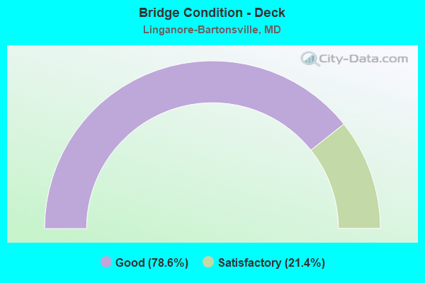
- Bridge Condition - Deck
- 78.6%Good
- 21.4%Satisfactory
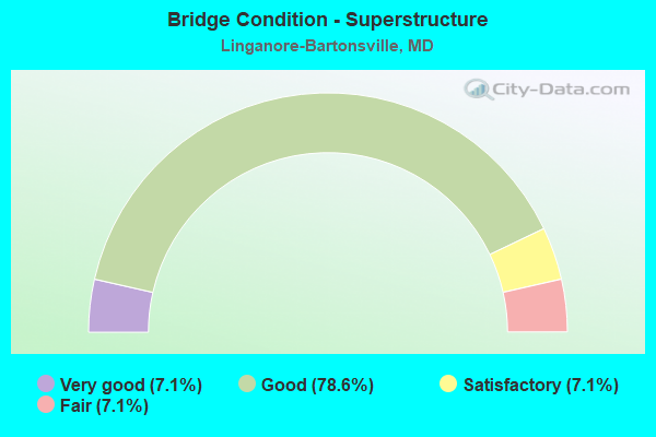
- Bridge Condition - Superstructure
- 7.1%Very good
- 78.6%Good
- 7.1%Satisfactory
- 7.1%Fair
- Bridge Condition - Substructure
- 7.1%Very good
- 57.1%Good
- 35.7%Satisfactory
- Bridge Condition - Channel
- 16.7%Very good
- 33.3%Good
- 50.0%Satisfactory

- Bridge Condition - Culverts
- 20.0%Good
- 40.0%Satisfactory
- 20.0%Fair
- 20.0%Serious
Find on map >> Show street view
Structure Number: 10000010002202, Location: 0.504 M W OF CAR. CO LINE (Lat: 39.394528, Lng: -77.334122), Route carried "on" structure: State highway 144FA, Year Built: 1954, Status: Open, Structure Length: 0.77m (2.53ft), Average Daily Traffic: 13,511 (year 2009), Truck Traffic: 8%, Average Future Daily Traffic: 16,985 (year 2026), Design Load: HS 20, Features Intersected: LONG BRANCH
Minimum Vertical Clearance: 30+ m (98+ ft), Kilometerpoint: 0.811, Lanes on structure: 7, Owner: State Highway Agency, Approaching Roadway Width: 36.0m (118.1ft), Skew: 3 degrees, Material/Design: Concrete, Design/Construction: Culvert, Length of Maximum Span: 7.6m (24.9ft)
Condition: Channel: Satisfactory, Culverts: Satisfactory, Operating Rating: 39.9 metric tons, Method Used To Determine Operating Rating: Load Factor (LF), Inventory Rating: 23.6 metric tons, Method Used To Determine Inventory Rating: Load Factor (LF), Structural Evaluation: Somewhat better than minimum adequacy, Waterway Adequacy: Equal to present minimum criteria, Approach Roadway Alignment: Equal to present desirable criteria, Designated Inspection Frequency: Every 24 months, Inspection Date: June 2021
Find on map >> Show street view
Structure Number: 10000010003801, Location: 1.04 MILE EAST OF IS 70 (Lat: 39.397950, Lng: -77.366136), Route carried "on" structure: State highway 144FA, Year Built: 1955, Year Reconstructed: 1987, Status: Open, Structure Length: 16.06m (52.69ft), Average Daily Traffic: 13,861 (year 2019), Truck Traffic: 8%, Average Future Daily Traffic: 14,663 (year 2041), Design Load: HS 20, Features Intersected: MONOCACY RIVER
Minimum Vertical Clearance: 30+ m (98+ ft), Kilometerpoint: 3.701, Lanes on structure: 2, Owner: State Highway Agency, Approaching Roadway Width: 13.4m (44.0ft), Material/Design: Steel continuous, Design/Construction: Truss - Deck, Number Of Spans In Main Unit: 3, Length of Maximum Span: 63.4m (208.0ft), Curb-To-Curb Width: 11.2m (36.7ft), Out-to-Out Width: 12.2m (40.0ft)
Condition: Deck: Satisfactory, Superstructure: Fair, Substructure: Satisfactory, Channel: Satisfactory, Operating Rating: 59.0 metric tons, Method Used To Determine Operating Rating: Load Factor (LF), Inventory Rating: 35.4 metric tons, Method Used To Determine Inventory Rating: Load Factor (LF), Structural Evaluation: Somewhat better than minimum adequacy, Deck Geometry: Meets minimum limits, Waterway Adequacy: Superior to present desirable criteria, Approach Roadway Alignment: Equal to present desirable criteria, Designated Inspection Frequency: Every 24 months, Critical Feature Inspection Frequency: Every 24 months, Underwater Inspection Frequency: Every 48 months, Inspection Date: August 2021, Critical Feature Inspection Date: August 2021, Underwater Inspection Date: August 2018, Deck Structure Type: Concrete Cast-file-Place, Wearing Surface/Protective System: Wearing Surface: Monolithic Concrete, Deck Protection: Epoxy Coated Reinforcing
Find on map >> Show street view
Structure Number: 10000010015701, Location: 2.11 MI W OF MD 75 (Lat: 39.386269, Lng: -77.298033), Route carried "on" structure: County highway 365, Year Built: 1973, Status: Open, Structure Length: 7.35m (24.11ft), Average Daily Traffic: 691 (year 1994), Truck Traffic: 5%, Average Future Daily Traffic: 1,178 (year 2012), Design Load: HS 20, Features Intersected: IS 70, Facility Carried by Structure: MUSSETTER ROAD
Minimum Vertical Clearance: 30+ m (98+ ft), Kilometerpoint: 3.652, Lanes on structure: 2, Lanes under structure: 6, Owner: State Highway Agency, Approaching Roadway Width: 13.4m (44.0ft), Material/Design: Steel continuous, Design/Construction: Stringer/Multi-beam, Number Of Spans In Main Unit: 2, Length of Maximum Span: 36.0m (118.1ft), Curb-To-Curb Width: 13.4m (44.0ft), Out-to-Out Width: 14.4m (47.2ft)
Condition: Deck: Satisfactory, Superstructure: Good, Substructure: Satisfactory, Operating Rating: 85.3 metric tons, Method Used To Determine Operating Rating: Load Factor (LF), Inventory Rating: 51.2 metric tons, Method Used To Determine Inventory Rating: Load Factor (LF), Structural Evaluation: Equal to present minimum criteria, Deck Geometry: Superior to present desirable criteria, Underclear: Better than present minimum criteria, Approach Roadway Alignment: Equal to present desirable criteria, Designated Inspection Frequency: Every 24 months, Inspection Date: April 2021, Deck Structure Type: Concrete Cast-file-Place, Wearing Surface/Protective System: Wearing Surface: Monolithic Concrete
Find on map >> Show street view
Structure Number: 100000100183013, Location: 0.22 M S OF BR NO 1018400 (Lat: 39.404261, Lng: -77.364711), Route carried "on" structure: Interstate 70, Year Built: 1985, Status: Open, Structure Length: 17.77m (58.30ft), Average Daily Traffic: 72,900 (year 2017), Truck Traffic: 8%, Average Future Daily Traffic: 112,137 (year 2039), Design Load: HS 20, Features Intersected: MONOCACY RIVER
Minimum Vertical Clearance: 30+ m (98+ ft), Kilometerpoint: 28.648, Lanes on structure: 3, Base Highway Network: Yes, Owner: State Highway Agency, Approaching Roadway Width: 17.1m (56.1ft), Material/Design: Steel continuous, Design/Construction: Stringer/Multi-beam, Number Of Spans In Main Unit: 4, Length of Maximum Span: 57.9m (190.0ft), Curb-To-Curb Width: 17.1m (56.1ft), Out-to-Out Width: 18.0m (59.1ft)
Condition: Deck: Good, Superstructure: Good, Substructure: Good, Channel: Very good, Operating Rating: 81.2 metric tons, Method Used To Determine Operating Rating: Load Factor (LF), Inventory Rating: 48.5 metric tons, Method Used To Determine Inventory Rating: Load Factor (LF), Structural Evaluation: Better than present minimum criteria, Deck Geometry: Equal to present minimum criteria, Waterway Adequacy: Equal to present desirable criteria, Approach Roadway Alignment: Equal to present desirable criteria, Designated Inspection Frequency: Every 24 months, Inspection Date: June 2020, Deck Structure Type: Concrete Cast-file-Place, Wearing Surface/Protective System: Wearing Surface: Monolithic Concrete, Deck Protection: Epoxy Coated Reinforcing
Find on map >> Show street view
Structure Number: 100000100183014, Location: 0.22 M S OF BR NO 1018400 (Lat: 39.404492, Lng: -77.364728), Route carried "on" structure: Interstate 70, Year Built: 1985, Status: Open, Structure Length: 17.77m (58.30ft), Average Daily Traffic: 72,900 (year 2017), Truck Traffic: 8%, Average Future Daily Traffic: 112,137 (year 2039), Design Load: HS 20, Features Intersected: MONOCACY RIVER
Minimum Vertical Clearance: 30+ m (98+ ft), Kilometerpoint: 28.648, Lanes on structure: 3, Base Highway Network: Yes, Owner: State Highway Agency, Approaching Roadway Width: 17.1m (56.1ft), Material/Design: Steel continuous, Design/Construction: Stringer/Multi-beam, Number Of Spans In Main Unit: 4, Length of Maximum Span: 57.9m (190.0ft), Curb-To-Curb Width: 17.1m (56.1ft), Out-to-Out Width: 18.0m (59.1ft)
Condition: Deck: Good, Superstructure: Good, Substructure: Good, Channel: Very good, Operating Rating: 81.2 metric tons, Method Used To Determine Operating Rating: Load Factor (LF), Inventory Rating: 48.5 metric tons, Method Used To Determine Inventory Rating: Load Factor (LF), Structural Evaluation: Better than present minimum criteria, Deck Geometry: Equal to present minimum criteria, Waterway Adequacy: Superior to present desirable criteria, Approach Roadway Alignment: Equal to present desirable criteria, Designated Inspection Frequency: Every 24 months, Inspection Date: June 2020, Deck Structure Type: Concrete Cast-file-Place, Wearing Surface/Protective System: Wearing Surface: Monolithic Concrete, Deck Protection: Epoxy Coated Reinforcing
Find on map >> Show street view
Structure Number: 10000010018401, Location: @ IS 270 (Lat: 39.404700, Lng: -77.362017), Route carried "on" structure: County highway 414, Year Built: 1985, Status: Open, Structure Length: 7.86m (25.79ft), Average Daily Traffic: 550 (year 2018), Truck Traffic: 5%, Average Future Daily Traffic: 700 (year 2040), Design Load: HS 20, Features Intersected: IS 70, Facility Carried by Structure: LINGANORE ROAD
Minimum Vertical Clearance: 30+ m (98+ ft), Kilometerpoint: 1.287, Lanes on structure: 2, Lanes under structure: 6, Owner: State Highway Agency, Approaching Roadway Width: 13.4m (44.0ft), Material/Design: Steel continuous, Design/Construction: Stringer/Multi-beam, Number Of Spans In Main Unit: 2, Length of Maximum Span: 43.6m (143.0ft), Curb-To-Curb Width: 13.4m (44.0ft), Out-to-Out Width: 14.4m (47.2ft)
Condition: Deck: Good, Superstructure: Good, Substructure: Good, Operating Rating: 82.1 metric tons, Method Used To Determine Operating Rating: Load Factor (LF), Inventory Rating: 49.4 metric tons, Method Used To Determine Inventory Rating: Load Factor (LF), Structural Evaluation: Better than present minimum criteria, Deck Geometry: Superior to present desirable criteria, Underclear: Better than present minimum criteria, Approach Roadway Alignment: Equal to present desirable criteria, Designated Inspection Frequency: Every 24 months, Inspection Date: Febuary 2022, Deck Structure Type: Concrete Cast-file-Place, Wearing Surface/Protective System: Wearing Surface: Monolithic Concrete, Deck Protection: Epoxy Coated Reinforcing
Find on map >> Show street view
Structure Number: 10000010018503, Location: 0.23 M E OF BR NO 1018400 (Lat: 39.404572, Lng: -77.357617), Route carried "on" structure: Interstate 70, Year Built: 1985, Status: Open, Structure Length: 2.02m (6.63ft), Average Daily Traffic: 62,311 (year 2013), Truck Traffic: 8%, Average Future Daily Traffic: 89,242 (year 2029), Design Load: HS 20, Features Intersected: LONG BRANCH
Minimum Vertical Clearance: 30+ m (98+ ft), Kilometerpoint: 29.445, Lanes on structure: 6, Base Highway Network: Yes, Owner: State Highway Agency, Approaching Roadway Width: 34.1m (111.9ft), Skew: 6 degrees, Material/Design: Steel, Design/Construction: Culvert, Length of Maximum Span: 9.1m (29.9ft)
Condition: Channel: Satisfactory, Culverts: Satisfactory, Structural Evaluation: Equal to present minimum criteria, Waterway Adequacy: Superior to present desirable criteria, Approach Roadway Alignment: Equal to present desirable criteria, Designated Inspection Frequency: Every 24 months, Inspection Date: September 2020
Find on map >> Show street view
Structure Number: 100000100186013, Location: 0.7 M E OF QUINN ROAD (Lat: 39.403917, Lng: -77.347708), Route carried "on" structure: Interstate 70, Year Built: 1985, Status: Open, Structure Length: 2.74m (8.99ft), Average Daily Traffic: 59,922 (year 2009), Truck Traffic: 8%, Average Future Daily Traffic: 89,242 (year 2029), Design Load: HS 20, Features Intersected: SPRING RIDGE PKWY
Minimum Vertical Clearance: 30+ m (98+ ft), Kilometerpoint: 30.318, Lanes on structure: 3, Lanes under structure: 2, Base Highway Network: Yes, Owner: State Highway Agency, Approaching Roadway Width: 17.1m (56.1ft), Material/Design: Steel, Design/Construction: Stringer/Multi-beam, Number Of Spans In Main Unit: 1, Length of Maximum Span: 26.2m (86.0ft), Curb-To-Curb Width: 17.1m (56.1ft), Out-to-Out Width: 18.0m (59.1ft)
Condition: Deck: Good, Superstructure: Good, Substructure: Good, Inventory Rating: 66.7 metric tons, Method Used To Determine Inventory Rating: Load Factor (LF), Structural Evaluation: Better than present minimum criteria, Deck Geometry: Equal to present minimum criteria, Underclear: Equal to present minimum criteria, Approach Roadway Alignment: Equal to present desirable criteria, Designated Inspection Frequency: Every 24 months, Inspection Date: May 2020, Deck Structure Type: Concrete Cast-file-Place, Wearing Surface/Protective System: Wearing Surface: Monolithic Concrete, Deck Protection: Epoxy Coated Reinforcing
Find on map >> Show street view
Structure Number: 100000100186014, Location: 0.7 M E OF QUINN ROAD (Lat: 39.404081, Lng: -77.347339), Route carried "on" structure: Interstate 70, Year Built: 1985, Status: Open, Structure Length: 2.74m (8.99ft), Average Daily Traffic: 59,922 (year 2009), Truck Traffic: 8%, Average Future Daily Traffic: 89,242 (year 2029), Design Load: HS 20, Features Intersected: SPRING RIDGE PKWY
Minimum Vertical Clearance: 30+ m (98+ ft), Kilometerpoint: 30.318, Lanes on structure: 3, Lanes under structure: 2, Base Highway Network: Yes, Owner: State Highway Agency, Approaching Roadway Width: 17.1m (56.1ft), Material/Design: Steel, Design/Construction: Stringer/Multi-beam, Number Of Spans In Main Unit: 1, Length of Maximum Span: 26.2m (86.0ft), Curb-To-Curb Width: 17.1m (56.1ft), Out-to-Out Width: 18.0m (59.1ft)
Condition: Deck: Good, Superstructure: Good, Substructure: Good, Inventory Rating: 66.7 metric tons, Method Used To Determine Inventory Rating: Load Factor (LF), Structural Evaluation: Better than present minimum criteria, Deck Geometry: Equal to present minimum criteria, Underclear: Superior to present desirable criteria, Approach Roadway Alignment: Equal to present desirable criteria, Designated Inspection Frequency: Every 24 months, Inspection Date: May 2020, Deck Structure Type: Concrete Cast-file-Place, Wearing Surface/Protective System: Wearing Surface: Monolithic Concrete, Deck Protection: Epoxy Coated Reinforcing
Find on map >> Show street view
Structure Number: 10000010018701, Location: 0.39 MI N OR CO 377 (Lat: 39.400425, Lng: -77.335642), Route carried "on" structure: County highway 852, Year Built: 1985, Status: Open, Structure Length: 7.50m (24.61ft), Average Daily Traffic: 792 (year 1994), Truck Traffic: 5%, Average Future Daily Traffic: 348 (year 2012), Design Load: HS 20, Features Intersected: IS 70, Facility Carried by Structure: QUINN ROAD
Minimum Vertical Clearance: 30+ m (98+ ft), Kilometerpoint: 0.885, Lanes on structure: 2, Lanes under structure: 6, Owner: State Highway Agency, Approaching Roadway Width: 13.4m (44.0ft), Skew: 2 degrees, Material/Design: Steel continuous, Design/Construction: Stringer/Multi-beam, Number Of Spans In Main Unit: 2, Length of Maximum Span: 36.9m (121.1ft), Curb-To-Curb Width: 13.4m (44.0ft), Out-to-Out Width: 14.4m (47.2ft)
Condition: Deck: Good, Superstructure: Good, Substructure: Satisfactory, Operating Rating: 63.9 metric tons, Method Used To Determine Operating Rating: Load Factor (LF), Inventory Rating: 38.5 metric tons, Method Used To Determine Inventory Rating: Load Factor (LF), Structural Evaluation: Equal to present minimum criteria, Deck Geometry: Superior to present desirable criteria, Underclear: Better than present minimum criteria, Approach Roadway Alignment: Equal to present desirable criteria, Designated Inspection Frequency: Every 24 months, Inspection Date: August 2020, Deck Structure Type: Concrete Cast-file-Place, Wearing Surface/Protective System: Wearing Surface: Monolithic Concrete, Deck Protection: Epoxy Coated Reinforcing
Find on map >> Show street view
Structure Number: 100000100188013, Location: 3.71 MILE WEST OF MD 75 (Lat: 39.393628, Lng: -77.326625), Route carried "on" structure: Interstate 70, Year Built: 1985, Status: Open, Structure Length: 5.49m (18.01ft), Average Daily Traffic: 59,922 (year 2009), Truck Traffic: 8%, Average Future Daily Traffic: 33,821 (year 2026), Design Load: HS 20, Features Intersected: OLD NATIONAL PIKE
Minimum Vertical Clearance: 30+ m (98+ ft), Kilometerpoint: 32.550, Lanes on structure: 3, Lanes under structure: 2, Base Highway Network: Yes, Owner: State Highway Agency, Approaching Roadway Width: 17.1m (56.1ft), Skew: 3 degrees, Material/Design: Steel continuous, Design/Construction: Stringer/Multi-beam, Number Of Spans In Main Unit: 2, Length of Maximum Span: 29.0m (95.1ft), Curb-To-Curb Width: 17.1m (56.1ft), Out-to-Out Width: 18.0m (59.1ft)
Condition: Deck: Good, Superstructure: Good, Substructure: Satisfactory, Operating Rating: 73.9 metric tons, Method Used To Determine Operating Rating: Load Factor (LF), Inventory Rating: 44.4 metric tons, Method Used To Determine Inventory Rating: Load Factor (LF), Structural Evaluation: Equal to present minimum criteria, Deck Geometry: Equal to present minimum criteria, Underclear: High priority of corrective action, Approach Roadway Alignment: Equal to present desirable criteria, Designated Inspection Frequency: Every 24 months, Inspection Date: June 2020, Deck Structure Type: Concrete Cast-file-Place, Wearing Surface/Protective System: Wearing Surface: Monolithic Concrete, Deck Protection: Epoxy Coated Reinforcing
Find on map >> Show street view
Structure Number: 100000100188014, Location: 3.71 MILE WEST OF MD 75 (Lat: 39.393358, Lng: -77.325847), Route carried "on" structure: Interstate 70, Year Built: 1985, Status: Open, Structure Length: 5.49m (18.01ft), Average Daily Traffic: 59,922 (year 2009), Truck Traffic: 8%, Average Future Daily Traffic: 33,821 (year 2026), Design Load: HS 20, Features Intersected: OLD NATIONAL PIKE
Minimum Vertical Clearance: 30+ m (98+ ft), Kilometerpoint: 32.550, Lanes on structure: 4, Lanes under structure: 2, Base Highway Network: Yes, Owner: State Highway Agency, Approaching Roadway Width: 20.7m (67.9ft), Skew: 3 degrees, Material/Design: Steel continuous, Design/Construction: Stringer/Multi-beam, Number Of Spans In Main Unit: 2, Length of Maximum Span: 29.0m (95.1ft), Curb-To-Curb Width: 20.7m (67.9ft), Out-to-Out Width: 21.7m (71.2ft)
Condition: Deck: Good, Superstructure: Good, Substructure: Satisfactory, Operating Rating: 68.0 metric tons, Method Used To Determine Operating Rating: Load Factor (LF), Inventory Rating: 40.8 metric tons, Method Used To Determine Inventory Rating: Load Factor (LF), Structural Evaluation: Equal to present minimum criteria, Deck Geometry: Equal to present minimum criteria, Underclear: High priority of corrective action, Approach Roadway Alignment: Equal to present desirable criteria, Designated Inspection Frequency: Every 24 months, Inspection Date: June 2020, Deck Structure Type: Concrete Cast-file-Place, Wearing Surface/Protective System: Wearing Surface: Monolithic Concrete, Deck Protection: Epoxy Coated Reinforcing
Find on map >> Show street view
Structure Number: 200000F-090301, Location: 0.87 MI N OF MD RTE 144 (Lat: 39.409861, Lng: -77.360461), Route carried "on" structure: County highway 414, Year Built: 1976, Status: Open, Structure Length: 7.41m (24.31ft), Average Daily Traffic: 2,461 (year 2018), Truck Traffic: 5%, Average Future Daily Traffic: 3,924 (year 2038), Design Load: HS 20, Features Intersected: LINGANORE CREEK, Facility Carried by Structure: LINGANORE ROAD
Minimum Vertical Clearance: 30+ m (98+ ft), Kilometerpoint: 3.701, Lanes on structure: 2, Owner: County Highway Agency, Approaching Roadway Width: 12.2m (40.0ft), Skew: 2 degrees, Material/Design: Steel continuous, Design/Construction: Stringer/Multi-beam, Number Of Spans In Main Unit: 3, Length of Maximum Span: 30.5m (100.1ft), Curb-To-Curb Width: 12.2m (40.0ft), Out-to-Out Width: 13.2m (43.3ft)
Condition: Deck: Satisfactory, Superstructure: Good, Substructure: Good, Channel: Satisfactory, Operating Rating: 69.4 metric tons, Method Used To Determine Operating Rating: Load Factor (LF), Inventory Rating: 41.3 metric tons, Method Used To Determine Inventory Rating: Load Factor (LF), Structural Evaluation: Better than present minimum criteria, Deck Geometry: Equal to present minimum criteria, Waterway Adequacy: Equal to present desirable criteria, Approach Roadway Alignment: Equal to present desirable criteria, Designated Inspection Frequency: Every 24 months, Inspection Date: June 2020, Deck Structure Type: Concrete Cast-file-Place, Wearing Surface/Protective System: Wearing Surface: Integral Concrete, Deck Protection: Epoxy Coated Reinforcing
Find on map >> Show street view
Structure Number: 200000F-090603, Location: 1.25 MI NORTH OF MD 144 (Lat: 39.402856, Lng: -77.304189), Route carried "on" structure: County highway 455, Year Built: 1982, Status: Open, Structure Length: 0.94m (3.08ft), Average Daily Traffic: 1,775 (year 2009), Truck Traffic: 1%, Average Future Daily Traffic: 2,130 (year 2032), Features Intersected: LOCAL STREAM, Facility Carried by Structure: YEAGERTOWN ROAD
Minimum Vertical Clearance: 30+ m (98+ ft), Kilometerpoint: 1.046, Lanes on structure: 2, Owner: County Highway Agency, Approaching Roadway Width: 3.0m (9.8ft), Skew: 2 degrees, Material/Design: Steel, Design/Construction: Culvert, Length of Maximum Span: 0.0m
Condition: Channel: Good, Culverts: Fair, Structural Evaluation: Somewhat better than minimum adequacy, Waterway Adequacy: Better than present minimum criteria, Approach Roadway Alignment: Equal to present minimum criteria, Designated Inspection Frequency: Every 24 months, Inspection Date: April 2021
Find on map >> Show street view
Structure Number: 200000F-092103, Location: 1.0 MI W OF CNTRL CHURCH (Lat: 39.427214, Lng: -77.281647), Route carried "on" structure: County highway 413, Year Built: 1962, Status: Closed, Structure Length: 1.49m (4.89ft), Average Daily Traffic: 1,618 (year 2009), Truck Traffic: 5%, Average Future Daily Traffic: 1,942 (year 2032), Features Intersected: LINGANORE CREEK, Facility Carried by Structure: GAS HOUSE PIKE
Minimum Vertical Clearance: 30+ m (98+ ft), Kilometerpoint: 12.068, Lanes on structure: 2, Owner: County Highway Agency, Approaching Roadway Width: 6.1m (20.0ft), Material/Design: Steel, Design/Construction: Culvert, Length of Maximum Span: 0.0m
Condition: Channel: Good, Culverts: Serious, Structural Evaluation: High priority of corrective action, Waterway Adequacy: High priority of corrective action, Approach Roadway Alignment: Equal to present desirable criteria, Designated Inspection Frequency: Every 12 months, Inspection Date: July 2020
Find on map >> Show street view
Structure Number: 200000F-092301, Location: AT MD 144 (Lat: 39.395900, Lng: -77.339500), Route carried "on" structure: County highway 852, Year Built: 2006, Status: Open, Structure Length: 2.04m (6.69ft), Average Daily Traffic: 3,143 (year 2021), Truck Traffic: 3%, Average Future Daily Traffic: 3,835 (year 2041), Design Load: HS 25 or greater, Features Intersected: LONG BRANCH, Facility Carried by Structure: TERRA FIRMA ROAD
Minimum Vertical Clearance: 30+ m (98+ ft), Kilometerpoint: 0.000, Lanes on structure: 3, Owner: County Highway Agency, Approaching Roadway Width: 13.4m (44.0ft), Material/Design: Prestressed concrete, Design/Construction: Stringer/Multi-beam, Number Of Spans In Main Unit: 1, Length of Maximum Span: 18.9m (62.0ft), Curb-To-Curb Width: 13.4m (44.0ft), Out-to-Out Width: 14.3m (46.9ft)
Condition: Deck: Good, Superstructure: Satisfactory, Substructure: Good, Channel: Good, Inventory Rating: 60.8 metric tons, Method Used To Determine Inventory Rating: Load Factor (LF), Structural Evaluation: Equal to present minimum criteria, Deck Geometry: Somewhat better than minimum adequacy, Waterway Adequacy: Superior to present desirable criteria, Approach Roadway Alignment: Equal to present desirable criteria, Designated Inspection Frequency: Every 24 months, Inspection Date: May 2021, Deck Structure Type: Concrete Cast-file-Place, Wearing Surface/Protective System: Wearing Surface: Integral Concrete
Find on map >> Show street view
Structure Number: 200000F-092601, Location: 0.2 MI N OF OLD NATL PIKE (Lat: 39.394294, Lng: -77.317606), Route carried "on" structure: County highway , Year Built: 2001, Status: Open, Structure Length: 1.79m (5.87ft), Average Daily Traffic: 1,790 (year 2021), Average Future Daily Traffic: 3,925 (year 2041), Design Load: HS 25 or greater, Features Intersected: TRIBUTARY TO LONG BRANCH, Facility Carried by Structure: OAKDALE SCHOOL ROA
Minimum Vertical Clearance: 30+ m (98+ ft), Kilometerpoint: 0.000, Lanes on structure: 2, Owner: County Highway Agency, Approaching Roadway Width: 11.0m (36.1ft), Skew: 21 degrees, Material/Design: Steel, Design/Construction: Stringer/Multi-beam, Number Of Spans In Main Unit: 1, Length of Maximum Span: 16.5m (54.1ft), Curb or Sidewalk Widths: Left: 1.3m (4.3ft), Right: 0.0m, Curb-To-Curb Width: 12.2m (40.0ft), Out-to-Out Width: 14.2m (46.6ft)
Condition: Deck: Good, Superstructure: Good, Substructure: Good, Channel: Good, Inventory Rating: 88.0 metric tons, Method Used To Determine Inventory Rating: Load Factor (LF), Structural Evaluation: Better than present minimum criteria, Deck Geometry: Better than present minimum criteria, Waterway Adequacy: Better than present minimum criteria, Approach Roadway Alignment: Equal to present desirable criteria, Length Of Structure Improvement: 1.80m (5.91ft), Designated Inspection Frequency: Every 24 months, Inspection Date: April 2021, Deck Structure Type: Concrete Cast-file-Place, Wearing Surface/Protective System: Wearing Surface: Monolithic Concrete, Deck Protection: Epoxy Coated Reinforcing
Find on map >> Show street view
Structure Number: 200000HO027203, Location: At Worthington Way (Lat: 39.408611, Lng: -77.325956), Route carried "on" structure: County highway , Year Built: 1990, Status: Open, Structure Length: 0.64m (2.10ft), Average Daily Traffic: 50 (year 2016), Average Future Daily Traffic: 50 (year 2037), Features Intersected: TRIB TO BONNIE BR, Facility Carried by Structure: ELLICOTT WOODS LN
Minimum Vertical Clearance: 2.99m (9.81ft), Kilometerpoint: 0.000, Lanes on structure: 2, Owner: County Highway Agency, Approaching Roadway Width: 8.2m (26.9ft), Skew: 1 degrees, Material/Design: Concrete, Design/Construction: Culvert, Length of Maximum Span: 1.8m (5.9ft)
Condition: Channel: Satisfactory, Culverts: Good, Operating Rating: 32.7 metric tons, Method Used To Determine Operating Rating: Field evaluation and documented engineering judgment, Inventory Rating: 32.7 metric tons, Method Used To Determine Inventory Rating: Field evaluation and documented engineering judgment, Structural Evaluation: Better than present minimum criteria, Waterway Adequacy: Equal to present desirable criteria, Approach Roadway Alignment: Equal to present desirable criteria, Designated Inspection Frequency: Every 24 months, Inspection Date: Febuary 2020
Find on map >> Show street view
Structure Number: 200000HO027301, Location: 75' W of Bonnie Branch Rd (Lat: 39.402778, Lng: -77.306406), Route carried "on" structure: County highway , Year Built: 2000, Status: Open, Structure Length: 0.70m (2.30ft), Average Daily Traffic: 25 (year 2016), Average Future Daily Traffic: 25 (year 2037), Features Intersected: TRIB TO BONNIE BR, Facility Carried by Structure: TWINSTREAM DRIVE
Minimum Vertical Clearance: 30+ m (98+ ft), Kilometerpoint: 0.000, Lanes on structure: 2, Owner: County Highway Agency, Approaching Roadway Width: 5.8m (19.0ft), Material/Design: Steel, Design/Construction: Arch - Deck, Number Of Spans In Main Unit: 1, Length of Maximum Span: 7.0m (23.0ft), Curb-To-Curb Width: 8.2m (26.9ft), Out-to-Out Width: 9.1m (29.9ft)
Condition: Deck: Good, Superstructure: Very good, Substructure: Very good, Channel: Satisfactory, Operating Rating: 44.9 metric tons, Method Used To Determine Operating Rating: Load Factor (LF), Inventory Rating: 38.1 metric tons, Method Used To Determine Inventory Rating: Load Factor (LF), Structural Evaluation: Equal to present desirable criteria, Deck Geometry: Equal to present minimum criteria, Approach Roadway Alignment: Equal to present desirable criteria, Designated Inspection Frequency: Every 24 months, Inspection Date: Febuary 2020
Find on map >> Show street view
Structure Number: 10000010015701, Location: 2.1 MILE WEST OF MD 75 (Lat: 39.386269, Lng: -77.298033), Route carried "under" structure: Interstate 70, Year Built: 1973, Structure Length: 0. m, Average Daily Traffic: 67,980 (year 2009), Features Intersected: IS 70, Facility Carried by Structure: MUSSETTER ROAD
Minimum Vertical Clearance: 5.18m (16.99ft), Kilometerpoint: 35.173, Lanes on structure: 2, Lanes under structure: 6, Material/Design: Steel continuous, Design/Construction: Stringer/Multi-beam, Length of Maximum Span: 36.0m (118.1ft)
Find on map >> Show street view
Structure Number: 10000010018401, Location: 1.48 M W OF QUINN ROAD (Lat: 39.404700, Lng: -77.362017), Route carried "under" structure: Interstate 70, Year Built: 1985, Structure Length: 0. m, Average Daily Traffic: 59,922 (year 2009), Features Intersected: IS 70, Facility Carried by Structure: LINGANORE ROAD
Minimum Vertical Clearance: 5.49m (18.01ft), Kilometerpoint: 29.075, Lanes on structure: 2, Lanes under structure: 6, Material/Design: Steel continuous, Design/Construction: Stringer/Multi-beam, Length of Maximum Span: 43.6m (143.0ft)
Find on map >> Show street view
Structure Number: 100000100186013, Location: 2.38 MI E OF FREDERICK (Lat: 39.403917, Lng: -77.347708), Route carried "under" structure: County highway 1475, Year Built: 1985, Structure Length: 0. m, Features Intersected: SPRING RIDGE PKWY, Facility Carried by Structure: IS 70 EBR
Minimum Vertical Clearance: 4.57m (14.99ft), Kilometerpoint: 0.837, Lanes on structure: 3, Lanes under structure: 2, Material/Design: Steel, Design/Construction: Stringer/Multi-beam, Length of Maximum Span: 26.2m (86.0ft)
Find on map >> Show street view
Structure Number: 100000100186014, Location: 2.38 MI E OF FREDERICK (Lat: 39.404081, Lng: -77.347339), Route carried "under" structure: County highway 1475, Year Built: 1985, Structure Length: 0. m, Features Intersected: SPRING RIDGE PKWY, Facility Carried by Structure: IS 70 WBR
Minimum Vertical Clearance: 4.57m (14.99ft), Kilometerpoint: 0.805, Lanes on structure: 3, Lanes under structure: 2, Material/Design: Steel, Design/Construction: Stringer/Multi-beam, Length of Maximum Span: 26.2m (86.0ft)
Find on map >> Show street view
Structure Number: 10000010018701, Location: 1.48 M E OF LINGANORE RD (Lat: 39.400425, Lng: -77.335642), Route carried "under" structure: Interstate 70, Year Built: 1985, Structure Length: 0. m, Average Daily Traffic: 59,922 (year 2009), Features Intersected: IS 70, Facility Carried by Structure: QUINN ROAD
Minimum Vertical Clearance: 5.49m (18.01ft), Kilometerpoint: 31.456, Lanes on structure: 2, Lanes under structure: 6, Material/Design: Steel continuous, Design/Construction: Stringer/Multi-beam, Length of Maximum Span: 36.9m (121.1ft)
Find on map >> Show street view
Structure Number: 100000100188013, Location: 3.93 MI W OF MD 75 (Lat: 39.393628, Lng: -77.326625), Route carried "under" structure: County highway 1317, Year Built: 1985, Structure Length: 0. m, Average Daily Traffic: 8,831 (year 2009), Features Intersected: OLD NATIONAL PIKE, Facility Carried by Structure: IS 70 EBR
Minimum Vertical Clearance: 4.88m (16.01ft), Kilometerpoint: 0.113, Lanes on structure: 3, Lanes under structure: 3, Material/Design: Steel continuous, Design/Construction: Stringer/Multi-beam, Length of Maximum Span: 29.0m (95.1ft)
Find on map >> Show street view
Structure Number: 100000100188014, Location: 3.93 MI W OF MD 75 (Lat: 39.393358, Lng: -77.325847), Route carried "under" structure: County highway 1317, Year Built: 1985, Structure Length: 0. m, Average Daily Traffic: 8,831 (year 2009), Features Intersected: OLD NATIONAL PIKE, Facility Carried by Structure: IS 70 WBR
Minimum Vertical Clearance: 4.88m (16.01ft), Kilometerpoint: 0.145, Lanes on structure: 4, Lanes under structure: 3, Material/Design: Steel continuous, Design/Construction: Stringer/Multi-beam, Length of Maximum Span: 29.0m (95.1ft)