Bridge Statistics for Linn Creek, Missouri (MO)
Condition, Traffic, Stress, Structural Evaluation, Project Costs
- National Bridge Inventory (NBI) Statistics
- 11Number of bridges
- 118ft / 35.6mTotal length
- $2,727,000Total costs
- 118,015Total average daily traffic
- 15,009Total average daily truck traffic
- National Bridge Inventory (NBI) Registered Bridges for Linn Creek
- No street view available for this location
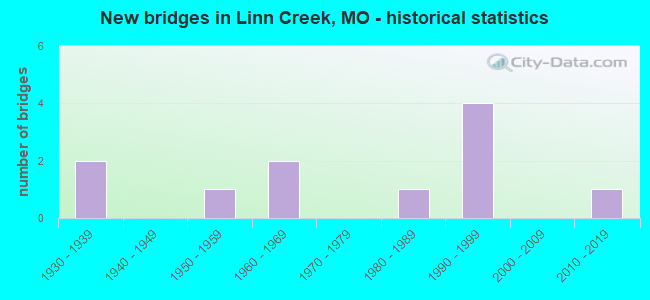
- New bridges - historical statistics
- 21930-1939
- 11950-1959
- 21960-1969
- 11980-1989
- 41990-1999
- 12010-2019


- Bridge Condition - Deck
- 12.5%Very good
- 62.5%Good
- 12.5%Satisfactory
- 12.5%Serious

- Bridge Condition - Superstructure
- 12.5%Excellent
- 12.5%Very good
- 50.0%Good
- 12.5%Satisfactory
- 12.5%Serious

- Bridge Condition - Substructure
- 25.0%Excellent
- 37.5%Good
- 12.5%Satisfactory
- 25.0%Fair

- Bridge Condition - Channel
- 12.5%Good
- 62.5%Satisfactory
- 25.0%Fair
Find on map >> Show street view
Structure Number: 11729, Location: S 17 T 38 N R 16 W (Lat: 38.030375, Lng: -92.714806), Route carried "on" structure: US 54, Year Built: 1964, Status: Open, Structure Length: 3.60m (11.81ft), Average Daily Traffic: 26,146 (year 2021), Truck Traffic: 13%, Average Future Daily Traffic: 45,756 (year 2041), Design Load: HS 20, Features Intersected: SOUTH F0RK LINN CR
Minimum Vertical Clearance: 30+ m (98+ ft), Kilometerpoint: 181.037, Lanes on structure: 2, Base Highway Network: Yes, Owner: State Highway Agency, Approaching Roadway Width: 13.4m (44.0ft), Skew: 4 degrees, Material/Design: Steel continuous, Design/Construction: Stringer/Multi-beam, Number Of Spans In Main Unit: 3, Length of Maximum Span: 13.1m (43.0ft), Curb-To-Curb Width: 8.8m (28.9ft), Out-to-Out Width: 9.6m (31.5ft)
Condition: Deck: Good, Superstructure: Good, Substructure: Good, Channel: Satisfactory, Operating Rating: 45.9 metric tons, Method Used To Determine Operating Rating: Load Factor (LF), Inventory Rating: 27.9 metric tons, Method Used To Determine Inventory Rating: Load Factor (LF), Structural Evaluation: Better than present minimum criteria, Deck Geometry: High priority of replacement, Waterway Adequacy: Equal to present desirable criteria, Approach Roadway Alignment: Equal to present desirable criteria, Length Of Structure Improvement: 0.45m (1.48ft), Designated Inspection Frequency: Every 24 months, Inspection Date: January 2022, Bridge Improvement Cost: $423,000, Roadway Improvement Cost: $42,000, Total Project Cost: $634,000 ( Estimate for 2022), Deck Structure Type: Concrete Cast-file-Place, Wearing Surface/Protective System: Wearing Surface: Other
Find on map >> Show street view
Structure Number: 11731, Location: S 17 T 38 N R 16 W (Lat: 38.037981, Lng: -92.706825), Route carried "on" structure: US 54, Year Built: 1964, Year Reconstructed: 1998, Status: Open, Structure Length: 4.85m (15.91ft), Average Daily Traffic: 33,755 (year 2021), Truck Traffic: 13%, Average Future Daily Traffic: 59,071 (year 2041), Design Load: HS 20, Features Intersected: NORTH FORK LINN CR
Minimum Vertical Clearance: 30+ m (98+ ft), Kilometerpoint: 182.131, Lanes on structure: 2, Base Highway Network: Yes, Owner: State Highway Agency, Approaching Roadway Width: 13.4m (44.0ft), Skew: 1 degrees, Material/Design: Steel continuous, Design/Construction: Stringer/Multi-beam, Number Of Spans In Main Unit: 3, Length of Maximum Span: 18.3m (60.0ft), Curb-To-Curb Width: 8.8m (28.9ft), Out-to-Out Width: 9.6m (31.5ft)
Condition: Deck: Good, Superstructure: Good, Substructure: Good, Channel: Satisfactory, Operating Rating: 47.7 metric tons, Method Used To Determine Operating Rating: Load Factor (LF), Inventory Rating: 28.8 metric tons, Method Used To Determine Inventory Rating: Load Factor (LF), Structural Evaluation: Better than present minimum criteria, Deck Geometry: High priority of replacement, Waterway Adequacy: Equal to present desirable criteria, Approach Roadway Alignment: Equal to present desirable criteria, Length Of Structure Improvement: 0.59m (1.94ft), Designated Inspection Frequency: Every 24 months, Inspection Date: January 2022, Bridge Improvement Cost: $554,000, Roadway Improvement Cost: $55,000, Total Project Cost: $831,000 ( Estimate for 2022), Deck Structure Type: Concrete Cast-file-Place, Wearing Surface/Protective System: Wearing Surface: Other
Find on map >> Show street view
Structure Number: 1193, Location: S 33 T 39 N R 16 W (Lat: 38.077086, Lng: -92.690108), Route carried "on" structure: State highway Y, Year Built: 1999, Status: Open, Structure Length: 6.40m (21.00ft), Average Daily Traffic: 3,264 (year 2021), Truck Traffic: 5%, Average Future Daily Traffic: 6,528 (year 2041), Design Load: HS 25 or greater, Features Intersected: US 54
Minimum Vertical Clearance: 30+ m (98+ ft), Kilometerpoint: 4.183, Lanes on structure: 2, Lanes under structure: 4, Owner: State Highway Agency, Approaching Roadway Width: 7.3m (24.0ft), Material/Design: Steel continuous, Design/Construction: Stringer/Multi-beam, Number Of Spans In Main Unit: 2, Length of Maximum Span: 34.1m (111.9ft), Curb-To-Curb Width: 11.8m (38.7ft), Out-to-Out Width: 12.6m (41.3ft)
Condition: Deck: Good, Superstructure: Very good, Substructure: Good, Operating Rating: 57.6 metric tons, Method Used To Determine Operating Rating: Load Factor (LF), Inventory Rating: 34.2 metric tons, Method Used To Determine Inventory Rating: Load Factor (LF), Structural Evaluation: Better than present minimum criteria, Deck Geometry: Somewhat better than minimum adequacy, Underclear: Better than present minimum criteria, Approach Roadway Alignment: Equal to present desirable criteria, Designated Inspection Frequency: Every 24 months, Inspection Date: January 2022, Deck Structure Type: Concrete Cast-file-Place, Wearing Surface/Protective System: Wearing Surface: Monolithic Concrete, Deck Protection: Epoxy Coated Reinforcing
Find on map >> Show street view
Structure Number: 20196, Location: S 8 T 38 N R 16 W (Lat: 38.037722, Lng: -92.710333), Route carried "on" structure: City street , Year Built: 1930, Status: Open, Structure Length: 2.93m (9.61ft), Average Daily Traffic: 600 (year 2021), Truck Traffic: 10%, Average Future Daily Traffic: 1,170 (year 2041), Features Intersected: S FORK OF LINN CR, Facility Carried by Structure: EAST VALLEY DR
Minimum Vertical Clearance: 30+ m (98+ ft), Kilometerpoint: 0.161, Lanes on structure: 2, Owner: County Highway Agency, Approaching Roadway Width: 6.1m (20.0ft), Material/Design: Concrete, Design/Construction: Tee Beam, Number Of Spans In Main Unit: 1, Number Of Approach Spans: 2, Length of Maximum Span: 12.8m (42.0ft), Curb-To-Curb Width: 7.3m (24.0ft), Out-to-Out Width: 8.2m (26.9ft)
Condition: Deck: Satisfactory, Superstructure: Satisfactory, Substructure: Fair, Channel: Satisfactory, Operating Rating: 39.6 metric tons, Method Used To Determine Operating Rating: Allowable Stress (AS), Inventory Rating: 20.7 metric tons, Method Used To Determine Inventory Rating: Allowable Stress (AS), Structural Evaluation: Somewhat better than minimum adequacy, Deck Geometry: Meets minimum limits, Waterway Adequacy: Better than present minimum criteria, Approach Roadway Alignment: Equal to present desirable criteria, Designated Inspection Frequency: Every 24 months, Inspection Date: March 2021, Deck Structure Type: Concrete Cast-file-Place, Wearing Surface/Protective System: Wearing Surface: Bituminous
Find on map >> Show street view
Structure Number: 3557, Location: S 17 T 38 N R 16 W (Lat: 38.037981, Lng: -92.706822), Route carried "on" structure: ServiceState highway 54, Year Built: 2017, Status: Open, Structure Length: 5.87m (19.26ft), Average Daily Traffic: 1,268 (year 2021), Truck Traffic: 10%, Average Future Daily Traffic: 2,536 (year 2041), Features Intersected: NORTH FORK OF LINN
Minimum Vertical Clearance: 30+ m (98+ ft), Kilometerpoint: 0.219, Lanes on structure: 2, Owner: State Highway Agency, Approaching Roadway Width: 7.3m (24.0ft), Skew: 1 degrees, Material/Design: Prestressed concrete continuous, Design/Construction: Stringer/Multi-beam, Number Of Spans In Main Unit: 3, Length of Maximum Span: 19.4m (63.6ft), Curb-To-Curb Width: 7.3m (24.0ft), Out-to-Out Width: 8.1m (26.6ft)
Condition: Deck: Good, Superstructure: Excellent, Substructure: Excellent, Channel: Good, Operating Rating: 83.7 metric tons, Method Used To Determine Operating Rating: Load Factor (LF), Inventory Rating: 50.4 metric tons, Method Used To Determine Inventory Rating: Load Factor (LF), Structural Evaluation: Superior to present desirable criteria, Deck Geometry: Meets minimum limits, Waterway Adequacy: Superior to present desirable criteria, Approach Roadway Alignment: Equal to present desirable criteria, Designated Inspection Frequency: Every 24 months, Inspection Date: January 2022, Deck Structure Type: Concrete Cast-file-Place, Wearing Surface/Protective System: Wearing Surface: Monolithic Concrete, Deck Protection: Epoxy Coated Reinforcing
Find on map >> Show street view
Structure Number: 4162, Location: S 17 T 38 N R 16 W (Lat: 38.038158, Lng: -92.707028), Route carried "on" structure: US 54, Year Built: 1995, Status: Open, Structure Length: 4.79m (15.72ft), Average Daily Traffic: 16,384 (year 2021), Truck Traffic: 13%, Average Future Daily Traffic: 28,672 (year 2041), Design Load: HS 25 or greater, Features Intersected: NORTH FORK LINN CR
Minimum Vertical Clearance: 30+ m (98+ ft), Kilometerpoint: 255.292, Lanes on structure: 3, Base Highway Network: Yes, Owner: State Highway Agency, Approaching Roadway Width: 10.4m (34.1ft), Skew: 1 degrees, Material/Design: Prestressed concrete continuous, Design/Construction: Stringer/Multi-beam, Number Of Spans In Main Unit: 3, Length of Maximum Span: 18.3m (60.0ft), Curb or Sidewalk Widths: Left: 0.2m (0.7ft), Right: 0.2m (0.7ft), Curb-To-Curb Width: 11.8m (38.7ft), Out-to-Out Width: 12.6m (41.3ft)
Condition: Deck: Very good, Superstructure: Good, Substructure: Excellent, Channel: Satisfactory, Operating Rating: 83.7 metric tons, Method Used To Determine Operating Rating: Load Factor (LF), Inventory Rating: 47.7 metric tons, Method Used To Determine Inventory Rating: Load Factor (LF), Structural Evaluation: Better than present minimum criteria, Deck Geometry: High priority of corrective action, Waterway Adequacy: Equal to present desirable criteria, Approach Roadway Alignment: Equal to present desirable criteria, Length Of Structure Improvement: 0.58m (1.90ft), Designated Inspection Frequency: Every 24 months, Inspection Date: January 2022, Bridge Improvement Cost: $612,000, Roadway Improvement Cost: $61,000, Total Project Cost: $918,000 ( Estimate for 2022), Deck Structure Type: Concrete Cast-file-Place, Wearing Surface/Protective System: Wearing Surface: Monolithic Concrete, Deck Protection: Epoxy Coated Reinforcing
Find on map >> Show street view
Structure Number: 6698, Location: S 28 T 38 N R 16 W (Lat: 37.999769, Lng: -92.684267), Route carried "on" structure: State highway V, Year Built: 1955, Status: Open, Structure Length: 0.85m (2.79ft), Average Daily Traffic: 1,604 (year 2021), Truck Traffic: 3%, Average Future Daily Traffic: 3,208 (year 2041), Design Load: H 10, Features Intersected: TOLER CREEK
Minimum Vertical Clearance: 30+ m (98+ ft), Kilometerpoint: 5.599, Lanes on structure: 2, Owner: State Highway Agency, Approaching Roadway Width: 7.3m (24.0ft), Material/Design: Concrete continuous, Design/Construction: Culvert, Number Of Spans In Main Unit: 3, Length of Maximum Span: 2.7m (8.9ft), Curb-To-Curb Width: 9.4m (30.8ft), Out-to-Out Width: 10.1m (33.1ft)
Condition: Channel: Satisfactory, Culverts: Good, Operating Rating: 47.7 metric tons, Method Used To Determine Operating Rating: Load Factor (LF), Inventory Rating: 28.8 metric tons, Method Used To Determine Inventory Rating: Load Factor (LF), Structural Evaluation: Better than present minimum criteria, Deck Geometry: Somewhat better than minimum adequacy, Waterway Adequacy: Equal to present minimum criteria, Approach Roadway Alignment: Equal to present minimum criteria, Designated Inspection Frequency: Every 24 months, Inspection Date: January 2022
Find on map >> Show street view
Structure Number: 944, Location: S 8 T 58 N R 35 W (Lat: 39.857969, Lng: -94.858850), Route carried "on" structure: Interstate 229, Year Built: 1985, Status: Open, Structure Length: 5.00m (16.40ft), Average Daily Traffic: 1,792 (year 2021), Truck Traffic: 22%, Average Future Daily Traffic: 3,763 (year 2041), Design Load: HS 20+Mod, Features Intersected: DILLON CR
Minimum Vertical Clearance: 30+ m (98+ ft), Kilometerpoint: 20.862, Lanes on structure: 2, Base Highway Network: Yes, Owner: State Highway Agency, Approaching Roadway Width: 12.2m (40.0ft), Skew: 12 degrees, Material/Design: Prestressed concrete continuous, Design/Construction: Stringer/Multi-beam, Number Of Spans In Main Unit: 3, Length of Maximum Span: 19.2m (63.0ft), Curb or Sidewalk Widths: Left: 0.2m (0.7ft), Right: 0.2m (0.7ft), Curb-To-Curb Width: 12.0m (39.4ft), Out-to-Out Width: 12.8m (42.0ft)
Condition: Deck: Good, Superstructure: Good, Substructure: Satisfactory, Channel: Fair, Operating Rating: 67.5 metric tons, Method Used To Determine Operating Rating: Load Factor (LF), Inventory Rating: 36.0 metric tons, Method Used To Determine Inventory Rating: Load Factor (LF), Structural Evaluation: Equal to present minimum criteria, Deck Geometry: Equal to present minimum criteria, Waterway Adequacy: Equal to present desirable criteria, Approach Roadway Alignment: Equal to present desirable criteria, Designated Inspection Frequency: Every 24 months, Inspection Date: September 2020, Deck Structure Type: Concrete Cast-file-Place, Wearing Surface/Protective System: Wearing Surface: Monolithic Concrete, Deck Protection: Internally Sealed
Find on map >> Show street view
Structure Number: 944, Location: S 17 T 38 N R 16 W (Lat: 38.036244, Lng: -92.711972), Route carried "on" structure: State highway V, Year Built: 1936, Status: Posted for load, Structure Length: 1.34m (4.40ft), Average Daily Traffic: 625 (year 2021), Truck Traffic: 11%, Average Future Daily Traffic: 1,250 (year 2041), Design Load: H 10, Features Intersected: LINN CREEK
Minimum Vertical Clearance: 30+ m (98+ ft), Kilometerpoint: 0.016, Lanes on structure: 2, Owner: State Highway Agency, Approaching Roadway Width: 6.7m (22.0ft), Skew: 2 degrees, Material/Design: Concrete, Design/Construction: Tee Beam, Number Of Spans In Main Unit: 2, Length of Maximum Span: 6.2m (20.3ft), Curb-To-Curb Width: 8.4m (27.6ft), Out-to-Out Width: 9.4m (30.8ft)
Condition: Deck: Serious, Superstructure: Serious, Substructure: Fair, Channel: Fair, Operating Rating: 18.0 metric tons, Method Used To Determine Operating Rating: Load Factor (LF), Inventory Rating: 10.8 metric tons, Method Used To Determine Inventory Rating: Load Factor (LF), Structural Evaluation: High priority of replacement, Deck Geometry: Somewhat better than minimum adequacy, Waterway Adequacy: Equal to present desirable criteria, Approach Roadway Alignment: Equal to present desirable criteria, Bridge Posting: Required (Relationship of Operating Rating to Maximum Legal Load: > 39.9% below), Length Of Structure Improvement: 0.20m (0.66ft), Designated Inspection Frequency: Every 12 months, Inspection Date: January 2022, Bridge Improvement Cost: $230,000, Roadway Improvement Cost: $23,000, Total Project Cost: $344,000 ( Estimate for 2022), Deck Structure Type: Concrete Cast-file-Place, Wearing Surface/Protective System: Wearing Surface: Bituminous
Find on map >> Show street view
Structure Number: 1193, Location: S 33 T 39 N R 16 W (Lat: 38.077086, Lng: -92.690108), Route carried "under" structure: US 54, Year Built: 1999, Structure Length: 0. m, Average Daily Traffic: 14,400 (year 2021), Truck Traffic: 13%, Features Intersected: US 54, Facility Carried by Structure: RT Y E
Minimum Vertical Clearance: 5.05m (16.57ft), Kilometerpoint: 250.569, Lanes on structure: 2, Lanes under structure: 2, Material/Design: Steel continuous, Design/Construction: Stringer/Multi-beam, Length of Maximum Span: 34.1m (111.9ft)
Find on map >> Show street view
Structure Number: 1193, Location: S 33 T 39 N R 16 W (Lat: 38.077086, Lng: -92.690108), Route carried "under" structure: US 54, Year Built: 1999, Structure Length: 0. m, Average Daily Traffic: 18,177 (year 2021), Truck Traffic: 13%, Features Intersected: US 54, Facility Carried by Structure: RT Y E
Minimum Vertical Clearance: 4.95m (16.24ft), Kilometerpoint: 186.919, Lanes on structure: 2, Lanes under structure: 2, Material/Design: Steel continuous, Design/Construction: Stringer/Multi-beam, Length of Maximum Span: 34.1m (111.9ft)