Bridge Statistics for Linwood, Kansas (KS)
Condition, Traffic, Stress, Structural Evaluation, Project Costs
- National Bridge Inventory (NBI) Statistics
- 13Number of bridges
- 249ft / 75.7mTotal length
- $1,485,000Total costs
- 35,116Total average daily traffic
- 6,527Total average daily truck traffic
- 56,298Total future (year 2038) average daily traffic
- National Bridge Inventory (NBI) Registered Bridges for Linwood
- No street view available for this location
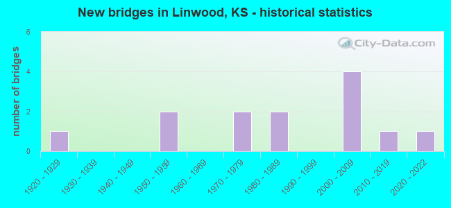
- New bridges - historical statistics
- 11920-1929
- 21950-1959
- 21970-1979
- 21980-1989
- 42000-2009
- 12010-2019
- 12020-2022

- Reconstructed bridges - Historical Statistics
- 11960-1969
- 01970-1979
- 21980-1989


- Bridge Condition - Deck
- 10.0%Very good
- 60.0%Good
- 30.0%Satisfactory

- Bridge Condition - Superstructure
- 20.0%Very good
- 70.0%Good
- 10.0%Satisfactory

- Bridge Condition - Substructure
- 20.0%Very good
- 80.0%Good

- Bridge Condition - Channel
- 15.4%Very good
- 30.8%Good
- 38.5%Satisfactory
- 15.4%Fair

- Bridge Condition - Culverts
- 33.3%Very good
- 66.7%Good
Find on map >> Show street view
Structure Number: 52002, Location: 1.5E 2.0S OF RENO (Lat: 39.023247, Lng: -95.093444), Route carried "on" structure: County highway 209, Year Built: 2009, Status: Open, Structure Length: 6.80m (22.31ft), Average Daily Traffic: 1,745 (year 2013), Truck Traffic: 7%, Average Future Daily Traffic: 4,220 (year 2038), Design Load: HS 20, Features Intersected: NINE MILE CREEK, Facility Carried by Structure: R-46 222ND STREET
Minimum Vertical Clearance: 30.47m (99.97ft), Kilometerpoint: 0.000, Lanes on structure: 2, Owner: County Highway Agency, Approaching Roadway Width: 10.9m (35.8ft), Skew: 3 degrees, Material/Design: Steel continuous, Design/Construction: Stringer/Multi-beam, Number Of Spans In Main Unit: 3, Length of Maximum Span: 26.2m (86.0ft), Curb-To-Curb Width: 11.0m (36.1ft), Out-to-Out Width: 11.6m (38.1ft)
Condition: Deck: Good, Superstructure: Good, Substructure: Very good, Channel: Very good, Operating Rating: 65.9 metric tons, Method Used To Determine Operating Rating: Load Factor (LF), Inventory Rating: 39.5 metric tons, Method Used To Determine Inventory Rating: Load Factor (LF), Structural Evaluation: Better than present minimum criteria, Deck Geometry: Equal to present minimum criteria, Waterway Adequacy: Equal to present desirable criteria, Approach Roadway Alignment: Equal to present desirable criteria, Designated Inspection Frequency: Every 24 months, Inspection Date: March 2020, Deck Structure Type: Concrete Cast-file-Place, Wearing Surface/Protective System: Wearing Surface: Integral Concrete
Find on map >> Show street view
Structure Number: 52003, Location: 1.5E 1.5S OF RENO (Lat: 39.029589, Lng: -95.093461), Route carried "on" structure: County highway 209, Year Built: 2009, Status: Open, Structure Length: 1.01m (3.31ft), Average Daily Traffic: 1,745 (year 2013), Truck Traffic: 7%, Average Future Daily Traffic: 4,220 (year 2038), Design Load: HS 20, Features Intersected: COW CREEK, Facility Carried by Structure: R-43 222ND STREET
Minimum Vertical Clearance: 30.47m (99.97ft), Kilometerpoint: 0.000, Lanes on structure: 2, Owner: County Highway Agency, Approaching Roadway Width: 10.9m (35.8ft), Skew: 3 degrees, Material/Design: Concrete, Design/Construction: Culvert, Number Of Spans In Main Unit: 2, Length of Maximum Span: 4.9m (16.1ft)
Condition: Channel: Satisfactory, Culverts: Good, Inventory Rating: 14.0 metric tons, Method Used To Determine Inventory Rating: Load Factor (LF), Structural Evaluation: Meets minimum limits, Waterway Adequacy: Better than present minimum criteria, Approach Roadway Alignment: Equal to present desirable criteria, Designated Inspection Frequency: Every 24 months, Inspection Date: March 2020, Deck Structure Type: Other, Wearing Surface/Protective System: Wearing Surface: Bituminous
Find on map >> Show street view
Structure Number: 520435, Location: 0.8W 0.8N OF LINWOOD (Lat: 39.010431, Lng: -95.056347), Route carried "on" structure: County highway 1847, Year Built: 2021, Status: Open, Structure Length: 5.56m (18.24ft), Average Daily Traffic: 575 (year 2016), Truck Traffic: 11%, Average Future Daily Traffic: 600 (year 2042), Design Load: HL 93, Features Intersected: NINE MILE CREEK, Facility Carried by Structure: SH-22 206TH ST
Minimum Vertical Clearance: 30.47m (99.97ft), Kilometerpoint: 0.000, Lanes on structure: 2, Owner: County Highway Agency, Approaching Roadway Width: 8.6m (28.2ft), Material/Design: Concrete, Design/Construction: Slab, Number Of Spans In Main Unit: 3, Length of Maximum Span: 21.9m (71.9ft), Curb-To-Curb Width: 9.8m (32.2ft), Out-to-Out Width: 10.4m (34.1ft)
Condition: Deck: Very good, Superstructure: Very good, Substructure: Very good, Channel: Satisfactory, Inventory Rating: 61.7 metric tons, Method Used To Determine Inventory Rating: Load Factor (LF), Structural Evaluation: Equal to present desirable criteria, Deck Geometry: Equal to present minimum criteria, Waterway Adequacy: Equal to present desirable criteria, Approach Roadway Alignment: Equal to present desirable criteria, Designated Inspection Frequency: Every 24 months, Inspection Date: December 2021, Deck Structure Type: Concrete Cast-file-Place, Wearing Surface/Protective System: Wearing Surface: Monolithic Concrete, Deck Protection: Epoxy Coated Reinforcing
Find on map >> Show street view
Structure Number: 52055, Location: 1 mi. N. on County Rte. 1 (Lat: 39.017564, Lng: -95.093572), Route carried "on" structure: County highway , Year Built: 2009, Status: Open, Structure Length: 0.87m (2.85ft), Average Daily Traffic: 1,745 (year 2013), Truck Traffic: 11%, Average Future Daily Traffic: 977 (year 2038), Design Load: HS 20, Features Intersected: Unnamed Creek, Facility Carried by Structure: R-47, 222nd Street
Minimum Vertical Clearance: 30.47m (99.97ft), Kilometerpoint: 0.000, Lanes on structure: 2, Owner: County Highway Agency, Approaching Roadway Width: 10.9m (35.8ft), Material/Design: Concrete, Design/Construction: Culvert, Number Of Spans In Main Unit: 2, Length of Maximum Span: 4.3m (14.1ft)
Condition: Channel: Satisfactory, Culverts: Good, Inventory Rating: 11.7 metric tons, Method Used To Determine Inventory Rating: Load Factor (LF), Structural Evaluation: High priority of corrective action, Waterway Adequacy: Equal to present minimum criteria, Approach Roadway Alignment: Equal to present desirable criteria, Designated Inspection Frequency: Every 24 months, Inspection Date: March 2020, Deck Structure Type: Other, Wearing Surface/Protective System: Wearing Surface: Bituminous
Find on map >> Show street view
Structure Number: 52106190436, Location: 1.0N 2.1W OF LINWOOD (Lat: 39.014936, Lng: -95.076492), Route carried "on" structure: County highway , Year Built: 1974, Status: Posted for load, Structure Length: 4.05m (13.29ft), Average Daily Traffic: 53 (year 2013), Truck Traffic: 16%, Average Future Daily Traffic: 97 (year 2038), Design Load: H 15, Features Intersected: NINE MILE CREEK, Facility Carried by Structure: R-50 LORING ROAD
Minimum Vertical Clearance: 30.47m (99.97ft), Kilometerpoint: 0.000, Lanes on structure: 2, Owner: County Highway Agency, Approaching Roadway Width: 6.7m (22.0ft), Material/Design: Concrete continuous, Design/Construction: Tee Beam, Number Of Spans In Main Unit: 3, Length of Maximum Span: 15.2m (49.9ft), Curb-To-Curb Width: 7.3m (24.0ft), Out-to-Out Width: 7.9m (25.9ft)
Condition: Deck: Satisfactory, Superstructure: Good, Substructure: Good, Channel: Satisfactory, Operating Rating: 26.1 metric tons, Method Used To Determine Operating Rating: Load Factor (LF), Inventory Rating: 9.9 metric tons, Method Used To Determine Inventory Rating: Load Factor (LF), Structural Evaluation: High priority of corrective action, Deck Geometry: Equal to present minimum criteria, Waterway Adequacy: Equal to present desirable criteria, Approach Roadway Alignment: Equal to present desirable criteria, Bridge Posting: Required (Relationship of Operating Rating to Maximum Legal Load: 20.0 - 29.9% below), Length Of Structure Improvement: 4.05m (13.29ft), Designated Inspection Frequency: Every 24 months, Inspection Date: March 2020, Bridge Improvement Cost: $256,000, Roadway Improvement Cost: $127,000, Total Project Cost: $575,000, Deck Structure Type: Concrete Cast-file-Place
Find on map >> Show street view
Structure Number: 521065704343, Location: 1.7N 0.2W OF LINWOOD (Lat: 39.027397, Lng: -95.042356), Route carried "on" structure: County highway , Year Built: 1984, Status: Posted for load, Structure Length: 7.19m (23.59ft), Average Daily Traffic: 17 (year 2013), Truck Traffic: 16%, Average Future Daily Traffic: 99 (year 2038), Design Load: H 20, Features Intersected: STRANGER CREEK, Facility Carried by Structure: SH-20 200TH St.
Minimum Vertical Clearance: 30.47m (99.97ft), Kilometerpoint: 0.000, Lanes on structure: 2, Owner: County Highway Agency, Approaching Roadway Width: 6.0m (19.7ft), Material/Design: Steel continuous, Design/Construction: Stringer/Multi-beam, Number Of Spans In Main Unit: 3, Length of Maximum Span: 27.3m (89.6ft), Curb-To-Curb Width: 7.3m (24.0ft), Out-to-Out Width: 7.9m (25.9ft)
Condition: Deck: Good, Superstructure: Good, Substructure: Good, Channel: Satisfactory, Operating Rating: 33.3 metric tons, Method Used To Determine Operating Rating: Allowable Stress (AS), Inventory Rating: 15.3 metric tons, Method Used To Determine Inventory Rating: Allowable Stress (AS), Structural Evaluation: Meets minimum limits, Deck Geometry: Equal to present minimum criteria, Waterway Adequacy: Somewhat better than minimum adequacy, Approach Roadway Alignment: Better than present minimum criteria, Bridge Posting: Required (Relationship of Operating Rating to Maximum Legal Load: 30.0 - 39.9% below), Designated Inspection Frequency: Every 24 months, Inspection Date: March 2020, Deck Structure Type: Concrete Cast-file-Place
Find on map >> Show street view
Structure Number: 521067004321, Location: 1.8E 4.1S OF TONGANOXIE (Lat: 39.042569, Lng: -95.037464), Route carried "on" structure: County highway , Year Built: 1980, Status: Open, Structure Length: 6.69m (21.95ft), Average Daily Traffic: 31 (year 2013), Average Future Daily Traffic: 62 (year 2038), Design Load: H 20, Features Intersected: STRANGER CREEK, Facility Carried by Structure: SH-14 198TH St.
Minimum Vertical Clearance: 30.47m (99.97ft), Kilometerpoint: 0.000, Lanes on structure: 2, Owner: County Highway Agency, Approaching Roadway Width: 6.0m (19.7ft), Material/Design: Concrete continuous, Design/Construction: Slab, Number Of Spans In Main Unit: 5, Length of Maximum Span: 14.6m (47.9ft), Curb-To-Curb Width: 7.3m (24.0ft), Out-to-Out Width: 7.9m (25.9ft)
Condition: Deck: Good, Superstructure: Good, Substructure: Good, Channel: Good, Operating Rating: 45.0 metric tons, Method Used To Determine Operating Rating: Load Factor (LF), Inventory Rating: 27.0 metric tons, Method Used To Determine Inventory Rating: Load Factor (LF), Structural Evaluation: Equal to present minimum criteria, Deck Geometry: Equal to present minimum criteria, Waterway Adequacy: Better than present minimum criteria, Approach Roadway Alignment: Better than present minimum criteria, Designated Inspection Frequency: Every 24 months, Inspection Date: March 2020, Deck Structure Type: Concrete Cast-file-Place
Find on map >> Show street view
Structure Number: 521067004366, Location: 0.3N OF LINWOOD (Lat: 39.009572, Lng: -95.038317), Route carried "on" structure: County highway , Year Built: 1971, Status: Posted for load, Structure Length: 4.46m (14.63ft), Average Daily Traffic: 201 (year 2013), Truck Traffic: 16%, Average Future Daily Traffic: 365 (year 2038), Design Load: H 15, Features Intersected: TRIB. TO STRANGER CREEK, Facility Carried by Structure: SH-21 198TH St.
Minimum Vertical Clearance: 30.47m (99.97ft), Kilometerpoint: 0.000, Lanes on structure: 2, Owner: County Highway Agency, Approaching Roadway Width: 7.3m (24.0ft), Material/Design: Concrete continuous, Design/Construction: Tee Beam, Number Of Spans In Main Unit: 3, Length of Maximum Span: 16.8m (55.1ft), Curb-To-Curb Width: 7.4m (24.3ft), Out-to-Out Width: 8.0m (26.2ft)
Condition: Deck: Satisfactory, Superstructure: Good, Substructure: Good, Channel: Good, Operating Rating: 29.7 metric tons, Method Used To Determine Operating Rating: Load Factor (LF), Inventory Rating: 18.0 metric tons, Method Used To Determine Inventory Rating: Load Factor (LF), Structural Evaluation: Somewhat better than minimum adequacy, Deck Geometry: Somewhat better than minimum adequacy, Waterway Adequacy: Somewhat better than minimum adequacy, Approach Roadway Alignment: Better than present minimum criteria, Length Of Structure Improvement: 4.45m (14.60ft), Designated Inspection Frequency: Every 24 months, Inspection Date: March 2020, Bridge Improvement Cost: $284,000, Roadway Improvement Cost: $143,000, Total Project Cost: $641,000, Deck Structure Type: Concrete Cast-file-Place
Find on map >> Show street view
Structure Number: 521067304322, Location: 2.9N OF LINWOOD (Lat: 39.040764, Lng: -95.032897), Route carried "on" structure: County highway , Year Built: 2017, Status: Open, Structure Length: 1.00m (3.28ft), Average Daily Traffic: 6 (year 2017), Average Future Daily Traffic: 6 (year 2038), Design Load: HS 20, Features Intersected: TRIB. TO STRANGER CREEK, Facility Carried by Structure: SH-15 STILLWELL
Minimum Vertical Clearance: 30.47m (99.97ft), Kilometerpoint: 0.000, Lanes on structure: 2, Owner: County Highway Agency, Approaching Roadway Width: 6.0m (19.7ft), Material/Design: Concrete, Design/Construction: Culvert, Number Of Spans In Main Unit: 2, Length of Maximum Span: 4.9m (16.1ft)
Condition: Channel: Very good, Culverts: Very good, Operating Rating: 67.9 metric tons, Method Used To Determine Operating Rating: Load and Resistance Factor (LRFR), Inventory Rating: 29.2 metric tons, Method Used To Determine Inventory Rating: Load and Resistance Factor (LRFR), Structural Evaluation: Better than present minimum criteria, Waterway Adequacy: Equal to present desirable criteria, Approach Roadway Alignment: Equal to present minimum criteria, Designated Inspection Frequency: Every 24 months, Inspection Date: March 2020
Find on map >> Show street view
Structure Number: 521069204287, Location: 4.3N 1.2E OF LINWOOD (Lat: 39.063706, Lng: -95.015575), Route carried "on" structure: County highway , Year Built: 1926, Year Reconstructed: 1960, Status: Posted for load, Structure Length: 0.96m (3.15ft), Average Daily Traffic: 28 (year 2013), Truck Traffic: 5%, Average Future Daily Traffic: 30 (year 2038), Features Intersected: TRIB. TO STRANGER CREEK, Facility Carried by Structure: ST-77 188TH STREET
Minimum Vertical Clearance: 30.47m (99.97ft), Kilometerpoint: 0.000, Lanes on structure: 2, Owner: County Highway Agency, Approaching Roadway Width: 4.8m (15.7ft), Material/Design: Steel, Design/Construction: Stringer/Multi-beam, Number Of Spans In Main Unit: 1, Length of Maximum Span: 9.0m (29.5ft), Curb-To-Curb Width: 5.7m (18.7ft), Out-to-Out Width: 5.8m (19.0ft)
Condition: Deck: Satisfactory, Superstructure: Satisfactory, Substructure: Good, Channel: Good, Operating Rating: 24.2 metric tons, Method Used To Determine Operating Rating: Load Factor (LF), Inventory Rating: 14.5 metric tons, Method Used To Determine Inventory Rating: Load Factor (LF), Structural Evaluation: Meets minimum limits, Deck Geometry: Meets minimum limits, Waterway Adequacy: Equal to present minimum criteria, Approach Roadway Alignment: Equal to present desirable criteria, Bridge Posting: Required (Relationship of Operating Rating to Maximum Legal Load: > 39.9% below), Length Of Structure Improvement: 1.62m (5.31ft), Designated Inspection Frequency: Every 24 months, Inspection Date: April 2020, Bridge Improvement Cost: $104,000, Roadway Improvement Cost: $75,000, Total Project Cost: $269,000, Deck Structure Type: Concrete Cast-file-Place
Find on map >> Show street view
Structure Number: 999903200520801, Location: 8.14 MI E KTA (Lat: 39.005833, Lng: -95.028333), Route carried "on" structure: State highway 32, Year Built: 2005, Status: Open, Structure Length: 13.20m (43.31ft), Average Daily Traffic: 2,760 (year 2020), Truck Traffic: 8%, Average Future Daily Traffic: 3,504 (year 2041), Design Load: HL 93, Features Intersected: STRANGER CREEK
Minimum Vertical Clearance: 30.47m (99.97ft), Kilometerpoint: 13.874, Lanes on structure: 2, Base Highway Network: Yes, Owner: State Highway Agency, Approaching Roadway Width: 13.4m (44.0ft), Material/Design: Steel continuous, Design/Construction: Stringer/Multi-beam, Number Of Spans In Main Unit: 3, Length of Maximum Span: 50.0m (164.0ft), Curb-To-Curb Width: 13.4m (44.0ft), Out-to-Out Width: 14.0m (45.9ft)
Condition: Deck: Good, Superstructure: Very good, Substructure: Good, Channel: Good, Operating Rating: 53.5 metric tons, Method Used To Determine Operating Rating: Load and Resistance Factor Rating (LRFR) rating reported by rating factor(RF) method using HL-93 loadings, Inventory Rating: 41.1 metric tons, Method Used To Determine Inventory Rating: Load and Resistance Factor Rating (LRFR) rating reported by rating factor(RF) method using HL-93 loadings, Structural Evaluation: Better than present minimum criteria, Deck Geometry: Better than present minimum criteria, Waterway Adequacy: Equal to present desirable criteria, Approach Roadway Alignment: Equal to present desirable criteria, Length Of Structure Improvement: 43.31m (142.09ft), Designated Inspection Frequency: Every 24 months, Inspection Date: June 2021, Wearing Surface/Protective System: Wearing Surface: Low Slump Concrete, Deck Protection: Epoxy Coated Reinforcing
Find on map >> Show street view
Structure Number: 999907000520393, Location: 9.57 MI E K-32 (Lat: 39.067778, Lng: -95.023889), Route carried "on" structure: Interstate 70, Year Built: 1956, Year Reconstructed: 1980, Status: Open, Structure Length: 11.96m (39.24ft), Average Daily Traffic: 13,105 (year 2020), Truck Traffic: 22%, Average Future Daily Traffic: 21,059 (year 2041), Design Load: HS 20+Mod, Features Intersected: STRANGER CREEK
Minimum Vertical Clearance: 30.47m (99.97ft), Kilometerpoint: 16.283, Lanes on structure: 2, Base Highway Network: Yes, Toll: On Interstate toll segment, Owner: State Toll Authority, Approaching Roadway Width: 11.0m (36.1ft), Material/Design: Steel continuous, Design/Construction: Stringer/Multi-beam, Number Of Spans In Main Unit: 4, Length of Maximum Span: 33.5m (109.9ft), Curb-To-Curb Width: 9.8m (32.2ft), Out-to-Out Width: 10.4m (34.1ft)
Condition: Deck: Good, Superstructure: Good, Substructure: Good, Channel: Fair, Operating Rating: 51.0 metric tons, Method Used To Determine Operating Rating: Load Factor (LF), Inventory Rating: 30.6 metric tons, Method Used To Determine Inventory Rating: Load Factor (LF), Structural Evaluation: Better than present minimum criteria, Deck Geometry: Meets minimum limits, Waterway Adequacy: Equal to present minimum criteria, Approach Roadway Alignment: Equal to present minimum criteria, Length Of Structure Improvement: 39.25m (128.77ft), Designated Inspection Frequency: Every 24 months, Inspection Date: June 2020, Deck Structure Type: Concrete Cast-file-Place, Wearing Surface/Protective System: Wearing Surface: Epoxy Overlay, Deck Protection: Epoxy Coated Reinforcing
Find on map >> Show street view
Structure Number: 999907000520403, Location: 9.58 MI E K-32 (Lat: 39.067778, Lng: -95.023889), Route carried "on" structure: Interstate 70, Year Built: 1956, Year Reconstructed: 1980, Status: Open, Structure Length: 11.96m (39.24ft), Average Daily Traffic: 13,105 (year 2020), Truck Traffic: 22%, Average Future Daily Traffic: 21,059 (year 2041), Design Load: HS 20+Mod, Features Intersected: STRANGER CREEK
Minimum Vertical Clearance: 30.47m (99.97ft), Kilometerpoint: 16.282, Lanes on structure: 2, Base Highway Network: Yes, Toll: On Interstate toll segment, Owner: State Toll Authority, Approaching Roadway Width: 11.0m (36.1ft), Material/Design: Steel continuous, Design/Construction: Stringer/Multi-beam, Number Of Spans In Main Unit: 4, Length of Maximum Span: 33.5m (109.9ft), Curb-To-Curb Width: 9.8m (32.2ft), Out-to-Out Width: 10.4m (34.1ft)
Condition: Deck: Good, Superstructure: Good, Substructure: Good, Channel: Fair, Operating Rating: 51.0 metric tons, Method Used To Determine Operating Rating: Load Factor (LF), Inventory Rating: 30.6 metric tons, Method Used To Determine Inventory Rating: Load Factor (LF), Structural Evaluation: Better than present minimum criteria, Deck Geometry: Meets minimum limits, Waterway Adequacy: Equal to present minimum criteria, Approach Roadway Alignment: Equal to present minimum criteria, Length Of Structure Improvement: 39.25m (128.77ft), Designated Inspection Frequency: Every 24 months, Inspection Date: June 2020, Deck Structure Type: Concrete Cast-file-Place, Wearing Surface/Protective System: Wearing Surface: Epoxy Overlay, Deck Protection: Epoxy Coated Reinforcing