Bridge Statistics for Little Canada, Minnesota (MN)
Condition, Traffic, Stress, Structural Evaluation, Project Costs
- National Bridge Inventory (NBI) Statistics
- 22Number of bridges
- 400ft / 122mTotal length
- 1,408,011Total average daily traffic
- 64,263Total average daily truck traffic
- National Bridge Inventory (NBI) Registered Bridges for Little Canada
- No street view available for this location
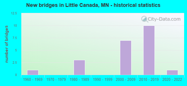
- New bridges - historical statistics
- 11960-1969
- 31980-1989
- 72000-2009
- 102010-2019
- 12020-2022


- Bridge Condition - Deck
- 27.3%Very good
- 54.5%Good
- 18.2%Satisfactory

- Bridge Condition - Superstructure
- 63.6%Very good
- 18.2%Good
- 9.1%Satisfactory
- 9.1%Fair

- Bridge Condition - Substructure
- 81.8%Good
- 9.1%Satisfactory
- 9.1%Fair
Find on map >> Show street view
Structure Number: 62001, Location: 0.6 MI S OF JCT TH 694 (Lat: 45.035828, Lng: -93.106217), Route carried "on" structure: County highway 49, Year Built: 1986, Status: Open, Structure Length: 4.10m (13.45ft), Average Daily Traffic: 12,800 (year 2015), Truck Traffic: 4%, Average Future Daily Traffic: 12,800 (year 2039), Design Load: HS 20, Features Intersected: BNSF RR
Minimum Vertical Clearance: 30+ m (98+ ft), Kilometerpoint: 0.000, Lanes on structure: 2, Owner: County Highway Agency, Approaching Roadway Width: 16.5m (54.1ft), Material/Design: Steel continuous, Design/Construction: Stringer/Multi-beam, Number Of Spans In Main Unit: 3, Length of Maximum Span: 15.2m (49.9ft), Curb or Sidewalk Widths: Left: 1.8m (5.9ft), Right: 1.8m (5.9ft), Curb-To-Curb Width: 17.4m (57.1ft), Out-to-Out Width: 21.7m (71.2ft)
Condition: Deck: Satisfactory, Superstructure: Satisfactory, Substructure: Good, Operating Rating: 54.9 metric tons, Method Used To Determine Operating Rating: Load Factor (LF), Inventory Rating: 33.0 metric tons, Method Used To Determine Inventory Rating: Load Factor (LF), Structural Evaluation: Equal to present minimum criteria, Deck Geometry: Superior to present desirable criteria, Underclear: Superior to present desirable criteria, Approach Roadway Alignment: Better than present minimum criteria, Designated Inspection Frequency: Every 24 months, Inspection Date: November 2021, Deck Structure Type: Concrete Cast-file-Place, Wearing Surface/Protective System: Wearing Surface: Low Slump Concrete, Deck Protection: Epoxy Coated Reinforcing
Find on map >> Show street view
Structure Number: 62631, Location: 0.8 MI W OF JCT TH 35E (Lat: 45.007644, Lng: -93.105897), Route carried "on" structure: County highway 49, Year Built: 2011, Status: Open, Structure Length: 5.18m (16.99ft), Average Daily Traffic: 23,900 (year 2015), Truck Traffic: 4%, Average Future Daily Traffic: 23,900 (year 2039), Design Load: HL 93, Features Intersected: TH 36
Minimum Vertical Clearance: 30+ m (98+ ft), Kilometerpoint: 0.000, Lanes on structure: 7, Lanes under structure: 4, Owner: State Highway Agency, Approaching Roadway Width: 23.8m (78.1ft), Skew: 20 degrees, Material/Design: Prestressed concrete, Design/Construction: Stringer/Multi-beam, Number Of Spans In Main Unit: 2, Length of Maximum Span: 25.2m (82.7ft), Curb or Sidewalk Widths: Left: 2.4m (7.9ft), Right: 2.4m (7.9ft), Curb-To-Curb Width: 29.0m (95.1ft), Out-to-Out Width: 35.4m (116.1ft)
Condition: Deck: Good, Superstructure: Very good, Substructure: Good, Operating Rating: 64.3 metric tons, Method Used To Determine Operating Rating: Load Factor (LF), Inventory Rating: 38.5 metric tons, Method Used To Determine Inventory Rating: Load Factor (LF), Structural Evaluation: Better than present minimum criteria, Deck Geometry: Somewhat better than minimum adequacy, Underclear: Better than present minimum criteria, Approach Roadway Alignment: Equal to present desirable criteria, Designated Inspection Frequency: Every 24 months, Inspection Date: May 2020, Deck Structure Type: Concrete Cast-file-Place, Wearing Surface/Protective System: Wearing Surface: Monolithic Concrete, Deck Protection: Epoxy Coated Reinforcing
Find on map >> Show street view
Structure Number: 62632, Location: 0.9 MI W OF JCT TH 35E (Lat: 45.007622, Lng: -93.107781), Route carried "on" structure: Ramp State highway 3739, Year Built: 2011, Status: Open, Structure Length: 7.67m (25.16ft), Average Daily Traffic: 1 (year 2012), Truck Traffic: 4%, Average Future Daily Traffic: 1 (year 2030), Design Load: HL 93, Features Intersected: TH 36
Minimum Vertical Clearance: 30+ m (98+ ft), Kilometerpoint: 0.000, Lanes on structure: 1, Lanes under structure: 4, Base Highway Network: Yes, Owner: State Highway Agency, Approaching Roadway Width: 10.1m (33.1ft), Skew: 4 degrees, Material/Design: Prestressed concrete, Design/Construction: Stringer/Multi-beam, Number Of Spans In Main Unit: 2, Length of Maximum Span: 37.2m (122.0ft), Curb-To-Curb Width: 9.1m (29.9ft), Out-to-Out Width: 10.3m (33.8ft)
Condition: Deck: Good, Superstructure: Very good, Substructure: Good, Operating Rating: 99.6 metric tons, Method Used To Determine Operating Rating: Load Factor (LF), Inventory Rating: 39.2 metric tons, Method Used To Determine Inventory Rating: Load Factor (LF), Structural Evaluation: Better than present minimum criteria, Deck Geometry: Superior to present desirable criteria, Underclear: Somewhat better than minimum adequacy, Approach Roadway Alignment: Equal to present desirable criteria, Designated Inspection Frequency: Every 24 months, Inspection Date: May 2020, Deck Structure Type: Concrete Cast-file-Place, Wearing Surface/Protective System: Wearing Surface: Low Slump Concrete, Deck Protection: Epoxy Coated Reinforcing
Find on map >> Show street view
Structure Number: 62633, Location: 0.7 MI W OF JCT TH 35E (Lat: 45.007611, Lng: -93.104828), Route carried "on" structure: Ramp State highway 5347, Year Built: 2011, Status: Open, Structure Length: 5.76m (18.90ft), Average Daily Traffic: 7,210 (year 2011), Truck Traffic: 5%, Average Future Daily Traffic: 7,210 (year 2033), Design Load: HL 93, Features Intersected: TH 36
Minimum Vertical Clearance: 30+ m (98+ ft), Kilometerpoint: 0.000, Lanes on structure: 2, Lanes under structure: 4, Base Highway Network: Yes, Owner: State Highway Agency, Approaching Roadway Width: 11.3m (37.1ft), Skew: 22 degrees, Material/Design: Prestressed concrete, Design/Construction: Stringer/Multi-beam, Number Of Spans In Main Unit: 2, Length of Maximum Span: 27.8m (91.2ft), Curb-To-Curb Width: 11.3m (37.1ft), Out-to-Out Width: 12.3m (40.4ft)
Condition: Deck: Very good, Superstructure: Very good, Substructure: Good, Operating Rating: 59.4 metric tons, Method Used To Determine Operating Rating: Load Factor (LF), Inventory Rating: 31.2 metric tons, Method Used To Determine Inventory Rating: Load Factor (LF), Structural Evaluation: Better than present minimum criteria, Deck Geometry: Superior to present desirable criteria, Underclear: Somewhat better than minimum adequacy, Approach Roadway Alignment: Equal to present minimum criteria, Designated Inspection Frequency: Every 24 months, Inspection Date: May 2020, Deck Structure Type: Concrete Cast-file-Place, Wearing Surface/Protective System: Wearing Surface: Low Slump Concrete, Deck Protection: Epoxy Coated Reinforcing
Find on map >> Show street view
Structure Number: 62896, Location: 0.9 MI N OF JCT TH 36 (Lat: 45.022900, Lng: -93.089731), Route carried "on" structure: County highway 21, Year Built: 1987, Status: Open, Structure Length: 6.06m (19.88ft), Average Daily Traffic: 13,000 (year 2015), Average Future Daily Traffic: 13,000 (year 2039), Design Load: HS 20, Features Intersected: I 35E
Minimum Vertical Clearance: 30+ m (98+ ft), Kilometerpoint: 0.000, Lanes on structure: 4, Lanes under structure: 6, Owner: State Highway Agency, Approaching Roadway Width: 14.6m (47.9ft), Skew: 2 degrees, Material/Design: Steel continuous, Design/Construction: Stringer/Multi-beam, Number Of Spans In Main Unit: 2, Length of Maximum Span: 29.6m (97.1ft), Curb or Sidewalk Widths: Left: 2.4m (7.9ft), Right: 1.8m (5.9ft), Curb-To-Curb Width: 20.7m (67.9ft), Out-to-Out Width: 25.7m (84.3ft)
Condition: Deck: Satisfactory, Superstructure: Fair, Substructure: Good, Operating Rating: 73.5 metric tons, Method Used To Determine Operating Rating: Load Factor (LF), Inventory Rating: 44.1 metric tons, Method Used To Determine Inventory Rating: Load Factor (LF), Structural Evaluation: Somewhat better than minimum adequacy, Deck Geometry: Superior to present desirable criteria, Underclear: Somewhat better than minimum adequacy, Approach Roadway Alignment: Equal to present desirable criteria, Designated Inspection Frequency: Every 24 months, Inspection Date: May 2020, Deck Structure Type: Concrete Cast-file-Place, Wearing Surface/Protective System: Wearing Surface: Low Slump Concrete, Deck Protection: Epoxy Coated Reinforcing
Find on map >> Show street view
Structure Number: 62902, Location: AT THE W JCT I 35E; 694 (Lat: 45.034783, Lng: -93.089219), Route carried "on" structure: Ramp Interstate 6430, Year Built: 2006, Status: Open, Structure Length: 58.76m (192.78ft), Average Daily Traffic: 23,000 (year 1996), Truck Traffic: 9%, Average Future Daily Traffic: 23,000 (year 2029), Design Load: HS 25 or greater, Features Intersected: I 35E , I 694; BNSF RR
Minimum Vertical Clearance: 30+ m (98+ ft), Kilometerpoint: 0.000, Lanes on structure: 2, Lanes under structure: 12, Base Highway Network: Yes, Owner: State Highway Agency, Approaching Roadway Width: 14.6m (47.9ft), Material/Design: Steel continuous, Design/Construction: Stringer/Multi-beam, Number Of Spans In Main Unit: 9, Length of Maximum Span: 82.3m (270.0ft), Curb-To-Curb Width: 14.6m (47.9ft), Out-to-Out Width: 15.6m (51.2ft)
Condition: Deck: Good, Superstructure: Very good, Substructure: Fair, Operating Rating: 65.3 metric tons, Method Used To Determine Operating Rating: Load Factor (LF), Inventory Rating: 39.2 metric tons, Method Used To Determine Inventory Rating: Load Factor (LF), Structural Evaluation: Somewhat better than minimum adequacy, Deck Geometry: Superior to present desirable criteria, Underclear: Somewhat better than minimum adequacy, Approach Roadway Alignment: Equal to present desirable criteria, Designated Inspection Frequency: Every 24 months, Inspection Date: August 2021, Deck Structure Type: Concrete Cast-file-Place, Wearing Surface/Protective System: Wearing Surface: Low Slump Concrete, Deck Protection: Epoxy Coated Reinforcing
Find on map >> Show street view
Structure Number: 62904, Location: AT THE W JCT I 35E; 694 (Lat: 45.037072, Lng: -93.090914), Route carried "on" structure: Interstate 694, Year Built: 2006, Status: Open, Structure Length: 4.37m (14.34ft), Average Daily Traffic: 54,500 (year 2019), Truck Traffic: 9%, Average Future Daily Traffic: 54,500 (year 2039), Design Load: HL 93, Features Intersected: BNSF RR
Minimum Vertical Clearance: 30+ m (98+ ft), Kilometerpoint: 0.000, Lanes on structure: 3, Base Highway Network: Yes, Owner: State Highway Agency, Approaching Roadway Width: 18.3m (60.0ft), Skew: 2 degrees, Material/Design: Prestressed concrete, Design/Construction: Stringer/Multi-beam, Number Of Spans In Main Unit: 3, Length of Maximum Span: 14.0m (45.9ft), Curb-To-Curb Width: 18.3m (60.0ft), Out-to-Out Width: 19.3m (63.3ft)
Condition: Deck: Good, Superstructure: Good, Substructure: Good, Operating Rating: 53.1 metric tons, Method Used To Determine Operating Rating: Load Factor (LF), Inventory Rating: 31.8 metric tons, Method Used To Determine Inventory Rating: Load Factor (LF), Structural Evaluation: Better than present minimum criteria, Deck Geometry: Better than present minimum criteria, Underclear: Better than present minimum criteria, Approach Roadway Alignment: Equal to present desirable criteria, Designated Inspection Frequency: Every 24 months, Inspection Date: August 2021, Deck Structure Type: Concrete Cast-file-Place, Wearing Surface/Protective System: Wearing Surface: Low Slump Concrete, Deck Protection: Epoxy Coated Reinforcing
Find on map >> Show street view
Structure Number: 62905, Location: AT THE W JCT TH 694; 35E (Lat: 45.034872, Lng: -93.086956), Route carried "on" structure: Interstate 694, Year Built: 2006, Status: Open, Structure Length: 13.29m (43.60ft), Average Daily Traffic: 54,500 (year 2019), Truck Traffic: 6%, Average Future Daily Traffic: 54,500 (year 2039), Design Load: HS 25 or greater, Features Intersected: I 35E
Minimum Vertical Clearance: 30+ m (98+ ft), Kilometerpoint: 0.000, Lanes on structure: 3, Lanes under structure: 6, Base Highway Network: Yes, Owner: State Highway Agency, Approaching Roadway Width: 18.3m (60.0ft), Skew: 5 degrees, Material/Design: Steel continuous, Design/Construction: Stringer/Multi-beam, Number Of Spans In Main Unit: 2, Length of Maximum Span: 72.5m (237.9ft), Curb-To-Curb Width: 18.3m (60.0ft), Out-to-Out Width: 19.3m (63.3ft)
Condition: Deck: Good, Superstructure: Very good, Substructure: Satisfactory, Operating Rating: 73.7 metric tons, Method Used To Determine Operating Rating: Load Factor (LF), Inventory Rating: 44.1 metric tons, Method Used To Determine Inventory Rating: Load Factor (LF), Structural Evaluation: Equal to present minimum criteria, Deck Geometry: Better than present minimum criteria, Underclear: Equal to present minimum criteria, Approach Roadway Alignment: Equal to present desirable criteria, Designated Inspection Frequency: Every 24 months, Inspection Date: August 2021, Deck Structure Type: Concrete Cast-file-Place, Wearing Surface/Protective System: Wearing Surface: Low Slump Concrete, Deck Protection: Epoxy Coated Reinforcing
Find on map >> Show street view
Structure Number: 62914, Location: AT THE W JCT I 694; 35E (Lat: 45.036981, Lng: -93.091497), Route carried "on" structure: Interstate 694, Year Built: 2006, Status: Open, Structure Length: 4.17m (13.68ft), Average Daily Traffic: 54,500 (year 2019), Truck Traffic: 6%, Average Future Daily Traffic: 54,500 (year 2039), Design Load: HL 93, Features Intersected: BNSF RR
Minimum Vertical Clearance: 30+ m (98+ ft), Kilometerpoint: 0.000, Lanes on structure: 5, Base Highway Network: Yes, Owner: State Highway Agency, Approaching Roadway Width: 25.6m (84.0ft), Skew: 2 degrees, Material/Design: Prestressed concrete, Design/Construction: Stringer/Multi-beam, Number Of Spans In Main Unit: 3, Length of Maximum Span: 13.5m (44.3ft), Curb-To-Curb Width: 26.5m (86.9ft), Out-to-Out Width: 27.6m (90.6ft)
Condition: Deck: Good, Superstructure: Good, Substructure: Good, Operating Rating: 56.1 metric tons, Method Used To Determine Operating Rating: Load Factor (LF), Inventory Rating: 33.7 metric tons, Method Used To Determine Inventory Rating: Load Factor (LF), Structural Evaluation: Better than present minimum criteria, Deck Geometry: Superior to present desirable criteria, Underclear: Equal to present minimum criteria, Approach Roadway Alignment: Equal to present desirable criteria, Designated Inspection Frequency: Every 24 months, Inspection Date: August 2021, Deck Structure Type: Concrete Cast-file-Place, Wearing Surface/Protective System: Wearing Surface: Low Slump Concrete, Deck Protection: Epoxy Coated Reinforcing
Find on map >> Show street view
Structure Number: 62933, Location: AT JCT 35E & TH36 (Lat: 45.010606, Lng: -93.089814), Route carried "on" structure: Interstate 35E, Year Built: 2015, Status: Open, Structure Length: 5.82m (19.09ft), Average Daily Traffic: 65,000 (year 2017), Truck Traffic: 5%, Average Future Daily Traffic: 65,000 (year 2039), Design Load: HL 93, Features Intersected: TH 36
Minimum Vertical Clearance: 30+ m (98+ ft), Kilometerpoint: 0.000, Lanes on structure: 5, Lanes under structure: 5, Base Highway Network: Yes, Owner: State Highway Agency, Approaching Roadway Width: 20.4m (66.9ft), Material/Design: Prestressed concrete, Design/Construction: Stringer/Multi-beam, Number Of Spans In Main Unit: 2, Length of Maximum Span: 28.5m (93.5ft), Curb-To-Curb Width: 26.7m (87.6ft), Out-to-Out Width: 26.7m (87.6ft)
Condition: Deck: Very good, Superstructure: Very good, Substructure: Good, Operating Rating: 53.1 metric tons, Method Used To Determine Operating Rating: Load and Resistance Factor Rating (LRFR) rating reported by rating factor(RF) method using HL-93 loadings, Inventory Rating: 39.9 metric tons, Method Used To Determine Inventory Rating: Load and Resistance Factor Rating (LRFR) rating reported by rating factor(RF) method using HL-93 loadings, Structural Evaluation: Better than present minimum criteria, Deck Geometry: Superior to present desirable criteria, Underclear: Equal to present minimum criteria, Approach Roadway Alignment: Equal to present desirable criteria, Designated Inspection Frequency: Every 24 months, Inspection Date: May 2020, Deck Structure Type: Concrete Cast-file-Place, Wearing Surface/Protective System: Wearing Surface: Monolithic Concrete, Deck Protection: Epoxy Coated Reinforcing
Find on map >> Show street view
Structure Number: 62934, Location: AT JCT TH 36; 35E (Lat: 45.010650, Lng: -93.089539), Route carried "on" structure: Interstate 35E, Year Built: 2014, Status: Open, Structure Length: 5.82m (19.09ft), Average Daily Traffic: 68,000 (year 2019), Truck Traffic: 5%, Average Future Daily Traffic: 65,000 (year 2039), Design Load: HL 93, Features Intersected: TH 36
Minimum Vertical Clearance: 30+ m (98+ ft), Kilometerpoint: 0.000, Lanes on structure: 6, Lanes under structure: 8, Base Highway Network: Yes, Owner: State Highway Agency, Approaching Roadway Width: 25.3m (83.0ft), Material/Design: Prestressed concrete, Design/Construction: Stringer/Multi-beam, Number Of Spans In Main Unit: 2, Length of Maximum Span: 28.6m (93.8ft), Curb-To-Curb Width: 25.8m (84.6ft), Out-to-Out Width: 26.7m (87.6ft)
Condition: Deck: Very good, Superstructure: Very good, Substructure: Good, Operating Rating: 48.0 metric tons, Method Used To Determine Operating Rating: Load and Resistance Factor Rating (LRFR) rating reported by rating factor(RF) method using HL-93 loadings, Inventory Rating: 34.7 metric tons, Method Used To Determine Inventory Rating: Load and Resistance Factor Rating (LRFR) rating reported by rating factor(RF) method using HL-93 loadings, Structural Evaluation: Better than present minimum criteria, Deck Geometry: Meets minimum limits, Underclear: Meets minimum limits, Approach Roadway Alignment: Equal to present desirable criteria, Designated Inspection Frequency: Every 24 months, Inspection Date: May 2020, Deck Structure Type: Concrete Cast-file-Place, Wearing Surface/Protective System: Wearing Surface: Monolithic Concrete, Deck Protection: Epoxy Coated Reinforcing
Find on map >> Show street view
Structure Number: 62J21, Location: 0.2 MI NE OF JCT CSAH 58 (Lat: 45.023658, Lng: -93.074644), Route carried "on" structure: County highway 22, Year Built: 2021, Status: Open, Structure Length: 1.10m (3.61ft), Average Daily Traffic: 1,600 (year 2020), Average Future Daily Traffic: 1,600 (year 2040), Design Load: HL 93, Features Intersected: GERVAIS CREEK
Minimum Vertical Clearance: 30+ m (98+ ft), Kilometerpoint: 0.000, Lanes on structure: 2, Owner: County Highway Agency, Approaching Roadway Width: 9.1m (29.9ft), Skew: 1 degrees, Material/Design: Concrete, Design/Construction: Culvert, Number Of Spans In Main Unit: 2, Length of Maximum Span: 5.0m (16.4ft)
Condition: Channel: Excellent, Culverts: Excellent, Operating Rating: 42.1 metric tons, Method Used To Determine Operating Rating: Assigned ratings based on Load and Resistance Factor Design (LRFD) reported by rating factor (RF) using HL93 loadings, Inventory Rating: 32.4 metric tons, Method Used To Determine Inventory Rating: Assigned ratings based on Load and Resistance Factor Design (LRFD) reported by rating factor (RF) using HL93 loadings, Structural Evaluation: Equal to present desirable criteria, Waterway Adequacy: Equal to present desirable criteria, Approach Roadway Alignment: Better than present minimum criteria, Designated Inspection Frequency: Every 24 months, Inspection Date: October 2021
Find on map >> Show street view
Structure Number: 62631, Location: 0.8 MI W OF JCT TH 35E (Lat: 45.007644, Lng: -93.105897), Route carried "under" structure: State highway 36, Year Built: 2011, Structure Length: 0. m, Average Daily Traffic: 86,000 (year 2019), Truck Traffic: 3%, Features Intersected: TH 36, Facility Carried by Structure: CSAH 49
Minimum Vertical Clearance: 5.40m (17.72ft), Kilometerpoint: 0.000, Lanes under structure: 4, Material/Design: Prestressed concrete, Design/Construction: Stringer/Multi-beam, Length of Maximum Span: 25.2m (82.7ft)
Find on map >> Show street view
Structure Number: 62632, Location: 0.9 MI W OF JCT TH 35E (Lat: 45.007622, Lng: -93.107781), Route carried "under" structure: State highway 36, Year Built: 2011, Structure Length: 0. m, Average Daily Traffic: 86,000 (year 2019), Truck Traffic: 3%, Features Intersected: TH 36, Facility Carried by Structure: CON 3739
Minimum Vertical Clearance: 4.97m (16.31ft), Kilometerpoint: 0.000, Lanes under structure: 4, Material/Design: Prestressed concrete, Design/Construction: Stringer/Multi-beam, Length of Maximum Span: 37.2m (122.0ft)
Find on map >> Show street view
Structure Number: 62633, Location: 0.7 MI W OF JCT TH 35E (Lat: 45.007611, Lng: -93.104828), Route carried "under" structure: State highway 36, Year Built: 2011, Structure Length: 0. m, Average Daily Traffic: 86,000 (year 2019), Truck Traffic: 3%, Features Intersected: TH 36, Facility Carried by Structure: CON 5347
Minimum Vertical Clearance: 5.49m (18.01ft), Kilometerpoint: 0.000, Lanes under structure: 4, Material/Design: Prestressed concrete, Design/Construction: Stringer/Multi-beam, Length of Maximum Span: 27.8m (91.2ft)
Find on map >> Show street view
Structure Number: 62896, Location: 0.9 MI N OF JCT TH 36 (Lat: 45.022900, Lng: -93.089731), Route carried "under" structure: Interstate 35E, Year Built: 1987, Structure Length: 0. m, Average Daily Traffic: 135,000 (year 2019), Truck Traffic: 5%, Features Intersected: I 35E, Facility Carried by Structure: CSAH 21
Minimum Vertical Clearance: 5.21m (17.09ft), Kilometerpoint: 0.000, Lanes on structure: 4, Lanes under structure: 6, Material/Design: Steel continuous, Design/Construction: Stringer/Multi-beam, Length of Maximum Span: 29.6m (97.1ft)
Find on map >> Show street view
Structure Number: 62902, Location: AT THE W JCT I 35E; 694 (Lat: 45.034783, Lng: -93.089219), Route carried "under" structure: Interstate 694, Year Built: 2006, Structure Length: 0. m, Average Daily Traffic: 109,000 (year 2019), Truck Traffic: 6%, Features Intersected: I 35E , I 694; BNSF RR, Facility Carried by Structure: CON 6430
Minimum Vertical Clearance: 4.94m (16.21ft), Kilometerpoint: 0.000, Lanes on structure: 2, Lanes under structure: 6, Material/Design: Steel continuous, Design/Construction: Stringer/Multi-beam, Length of Maximum Span: 82.3m (270.0ft)
Find on map >> Show street view
Structure Number: 62902, Location: AT THE W JCT I 35E; 694 (Lat: 45.034783, Lng: -93.089219), Route carried "under" structure: Interstate 35E, Year Built: 2006, Structure Length: 0. m, Average Daily Traffic: 135,000 (year 2019), Truck Traffic: 5%, Features Intersected: I 35E , I 694; BNSF RR, Facility Carried by Structure: CON 6430
Minimum Vertical Clearance: 4.94m (16.21ft), Kilometerpoint: 0.000, Lanes on structure: 2, Lanes under structure: 6, Material/Design: Steel continuous, Design/Construction: Stringer/Multi-beam, Length of Maximum Span: 82.3m (270.0ft)
Find on map >> Show street view
Structure Number: 62905, Location: AT THE W JCT TH 694; 35E (Lat: 45.034872, Lng: -93.086956), Route carried "under" structure: Interstate 35E, Year Built: 2006, Structure Length: 0. m, Average Daily Traffic: 135,000 (year 2019), Truck Traffic: 5%, Features Intersected: I 35E, Facility Carried by Structure: I 694
Minimum Vertical Clearance: 5.18m (16.99ft), Kilometerpoint: 0.000, Lanes on structure: 3, Lanes under structure: 6, Material/Design: Steel continuous, Design/Construction: Stringer/Multi-beam, Length of Maximum Span: 72.5m (237.9ft)
Find on map >> Show street view
Structure Number: 62933, Location: AT JCT 35E & TH36 (Lat: 45.010606, Lng: -93.089814), Route carried "under" structure: State highway 36, Year Built: 2015, Structure Length: 0. m, Average Daily Traffic: 86,000 (year 2019), Truck Traffic: 3%, Features Intersected: TH 36, Facility Carried by Structure: I 35E
Minimum Vertical Clearance: 5.18m (16.99ft), Kilometerpoint: 0.000, Lanes under structure: 5, Material/Design: Prestressed concrete, Design/Construction: Stringer/Multi-beam, Length of Maximum Span: 28.5m (93.5ft)
Find on map >> Show street view
Structure Number: 62934, Location: AT JCT TH 36; 35E (Lat: 45.010650, Lng: -93.089539), Route carried "under" structure: State highway 36, Year Built: 2014, Structure Length: 0. m, Average Daily Traffic: 86,000 (year 2019), Truck Traffic: 3%, Features Intersected: TH 36, Facility Carried by Structure: I 35E
Minimum Vertical Clearance: 5.61m (18.41ft), Kilometerpoint: 0.000, Lanes under structure: 8, Material/Design: Prestressed concrete, Design/Construction: Stringer/Multi-beam, Length of Maximum Span: 28.6m (93.8ft)
Find on map >> Show street view
Structure Number: 9212, Location: 0.3 MI W OF JCT TH 35E (Lat: 45.009450, Lng: -93.095114), Route carried "under" structure: State highway 36, Year Built: 1960, Structure Length: 0. m, Average Daily Traffic: 86,000 (year 2019), Truck Traffic: 3%, Features Intersected: TH 36, Facility Carried by Structure: RAILROAD
Minimum Vertical Clearance: 4.63m (15.19ft), Kilometerpoint: 0.000, Lanes on structure: 4, Lanes under structure: 4, Material/Design: Steel, Design/Construction: Girder and Floorbeam System, Length of Maximum Span: 18.8m (61.7ft)