Bridge Statistics for Little Falls, New York (NY)
Condition, Traffic, Stress, Structural Evaluation, Project Costs
- National Bridge Inventory (NBI) Statistics
- 15Number of bridges
- 427ft / 130mTotal length
- $48,516,000Total costs
- 49,692Total average daily traffic
- 6,297Total average daily truck traffic
- National Bridge Inventory (NBI) Registered Bridges for Little Falls
- No street view available for this location
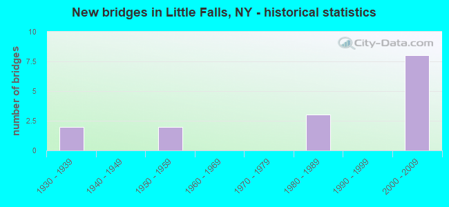
- New bridges - historical statistics
- 21930-1939
- 21950-1959
- 31980-1989
- 82000-2009

- Reconstructed bridges - Historical Statistics
- 21980-1989
- 01990-1999
- 12000-2009


- Bridge Condition - Deck
- 11.1%Excellent
- 22.2%Very good
- 55.6%Good
- 11.1%Satisfactory

- Bridge Condition - Superstructure
- 55.6%Excellent
- 33.3%Good
- 11.1%Poor

- Bridge Condition - Substructure
- 44.4%Very good
- 33.3%Good
- 11.1%Fair
- 11.1%Poor

- Bridge Condition - Channel
- 20.0%Excellent
- 20.0%Very good
- 20.0%Good
- 20.0%Satisfactory
- 20.0%Fair
Find on map >> Show street view
Structure Number: 107841, Location: .1 MI S JCT SH 5 & SH 167 (Lat: 43.041594, Lng: -74.860669), Route carried "on" structure: State highway 167, Year Built: 2004, Status: Open, Structure Length: 5.15m (16.90ft), Average Daily Traffic: 3,360 (year 2020), Truck Traffic: 8%, Average Future Daily Traffic: 4,081 (year 2040), Design Load: HS 25 or greater, Features Intersected: RTE 5, CSX TRANS/AMTRAK
Minimum Vertical Clearance: 30+ m (98+ ft), Kilometerpoint: 27.852, Lanes on structure: 3, Lanes under structure: 4, Base Highway Network: Yes, Owner: State Highway Agency, Approaching Roadway Width: 12.8m (42.0ft), Material/Design: Steel, Design/Construction: Stringer/Multi-beam, Number Of Spans In Main Unit: 1, Length of Maximum Span: 50.0m (164.0ft), Curb or Sidewalk Widths: Left: 0.0m, Right: 2.2m (7.2ft), Curb-To-Curb Width: 12.9m (42.3ft), Out-to-Out Width: 15.7m (51.5ft)
Condition: Deck: Good, Superstructure: Excellent, Substructure: Very good, Operating Rating: 82.6 metric tons, Method Used To Determine Operating Rating: Load Factor (LF), Inventory Rating: 49.0 metric tons, Method Used To Determine Inventory Rating: Load Factor (LF), Structural Evaluation: Equal to present desirable criteria, Deck Geometry: Meets minimum limits, Underclear: Equal to present minimum criteria, Approach Roadway Alignment: High priority of corrective action, Length Of Structure Improvement: 5.15m (16.90ft), Designated Inspection Frequency: Every 24 months, Inspection Date: August 2021, Bridge Improvement Cost: $1,921,000, Roadway Improvement Cost: $1,125,000, Total Project Cost: $3,046,000 ( Estimate for 2021), Deck Structure Type: Concrete Cast-file-Place, Wearing Surface/Protective System: Wearing Surface: Integral Concrete, Deck Protection: Epoxy Coated Reinforcing
Find on map >> Show street view
Structure Number: 225553, Location: CITY OF LITTLE FALLS (Lat: 43.038011, Lng: -74.865353), Route carried "on" structure: City street , Year Built: 1939, Year Reconstructed: 1991, Status: Open, Structure Length: 4.42m (14.50ft), Average Daily Traffic: 38 (year 2017), Truck Traffic: 4%, Average Future Daily Traffic: 53 (year 2037), Design Load: HS 20+Mod, Features Intersected: MOHAWK RIVER, Facility Carried by Structure: HANSEN AVENUE
Minimum Vertical Clearance: 30+ m (98+ ft), Kilometerpoint: 0.016, Lanes on structure: 2, Owner: City or Municipal Highway Agency, Approaching Roadway Width: 7.3m (24.0ft), Material/Design: Steel, Design/Construction: Truss - Thru, Number Of Spans In Main Unit: 1, Length of Maximum Span: 42.6m (139.8ft), Curb or Sidewalk Widths: Left: 0.0m, Right: 1.9m (6.2ft), Curb-To-Curb Width: 7.3m (24.0ft), Out-to-Out Width: 8.1m (26.6ft)
Condition: Deck: Good, Superstructure: Poor, Substructure: Poor, Channel: Good, Operating Rating: 29.5 metric tons, Method Used To Determine Operating Rating: Load and Resistance Factor Rating (LRFR) rating reported by rating factor(RF) method using HL-93 loadings, Inventory Rating: 22.7 metric tons, Method Used To Determine Inventory Rating: Load and Resistance Factor Rating (LRFR) rating reported by rating factor(RF) method using HL-93 loadings, Structural Evaluation: Meets minimum limits, Deck Geometry: Equal to present minimum criteria, Waterway Adequacy: Somewhat better than minimum adequacy, Approach Roadway Alignment: Somewhat better than minimum adequacy, Length Of Structure Improvement: 4.41m (14.47ft), Designated Inspection Frequency: Every 24 months, Critical Feature Inspection Frequency: Every 12 months, Inspection Date: August 2021, Critical Feature Inspection Date: August 2021, Bridge Improvement Cost: $3,001,000, Roadway Improvement Cost: $1,757,000, Total Project Cost: $4,759,000 ( Estimate for 2021), Deck Structure Type: Concrete Cast-file-Place, Wearing Surface/Protective System: Wearing Surface: Integral Concrete
Find on map >> Show street view
Structure Number: 225554, Location: CITY OF LITTLE FALLS (Lat: 43.040119, Lng: -74.858911), Route carried "on" structure: City street , Year Built: 1933, Year Reconstructed: 2013, Status: Posted for load, Structure Length: 4.45m (14.60ft), Average Daily Traffic: 145 (year 2017), Truck Traffic: 6%, Average Future Daily Traffic: 203 (year 2037), Design Load: H 20, Features Intersected: MOHAWK RIVER, Facility Carried by Structure: SOUTH ANN STREET
Minimum Vertical Clearance: 30+ m (98+ ft), Kilometerpoint: 0.000, Lanes on structure: 1, Owner: City or Municipal Highway Agency, Approaching Roadway Width: 5.5m (18.0ft), Material/Design: Steel, Design/Construction: Stringer/Multi-beam, Number Of Spans In Main Unit: 2, Length of Maximum Span: 29.3m (96.1ft), Curb or Sidewalk Widths: Left: 1.5m (4.9ft), Right: 0.0m, Curb-To-Curb Width: 4.6m (15.1ft), Out-to-Out Width: 7.1m (23.3ft)
Condition: Deck: Excellent, Superstructure: Excellent, Substructure: Good, Channel: Satisfactory, Operating Rating: 45.0 metric tons, Method Used To Determine Operating Rating: Load and Resistance Factor Rating (LRFR) rating reported by rating factor(RF) method using HL-93 loadings, Inventory Rating: 35.0 metric tons, Method Used To Determine Inventory Rating: Load and Resistance Factor Rating (LRFR) rating reported by rating factor(RF) method using HL-93 loadings, Structural Evaluation: Better than present minimum criteria, Deck Geometry: High priority of replacement, Waterway Adequacy: Equal to present desirable criteria, Approach Roadway Alignment: Equal to present desirable criteria, Bridge Posting: Required (Relationship of Operating Rating to Maximum Legal Load: > 39.9% below), Length Of Structure Improvement: 4.45m (14.60ft), Designated Inspection Frequency: Every 12 months, Inspection Date: June 2021, Bridge Improvement Cost: $629,000, Roadway Improvement Cost: $368,000, Total Project Cost: $998,000 ( Estimate for 2021), Deck Structure Type: Concrete Cast-file-Place, Wearing Surface/Protective System: Wearing Surface: Integral Concrete, Deck Protection: Epoxy Coated Reinforcing
Find on map >> Show street view
Structure Number: 226789, Location: 0.5 MI NE OF KAST BRIDGE (Lat: 43.076769, Lng: -74.928225), Route carried "on" structure: Other road , Year Built: 1989, Status: Posted for load, Structure Length: 0.85m (2.79ft), Average Daily Traffic: 42 (year 2016), Truck Traffic: 4%, Average Future Daily Traffic: 59 (year 2036), Features Intersected: NORTH CREEK, Facility Carried by Structure: EATONVILLE RD
Minimum Vertical Clearance: 30+ m (98+ ft), Kilometerpoint: 4.409, Lanes on structure: 1, Owner: Town or Township Highway Agency, Approaching Roadway Width: 3.7m (12.1ft), Material/Design: Steel, Design/Construction: Stringer/Multi-beam, Number Of Spans In Main Unit: 1, Length of Maximum Span: 7.9m (25.9ft), Curb-To-Curb Width: 5.4m (17.7ft), Out-to-Out Width: 6.1m (20.0ft)
Condition: Deck: Satisfactory, Superstructure: Good, Substructure: Fair, Channel: Fair, Operating Rating: 9.4 metric tons, Method Used To Determine Operating Rating: Load and Resistance Factor Rating (LRFR) rating reported by rating factor(RF) method using HL-93 loadings, Inventory Rating: 7.5 metric tons, Method Used To Determine Inventory Rating: Load and Resistance Factor Rating (LRFR) rating reported by rating factor(RF) method using HL-93 loadings, Structural Evaluation: High priority of corrective action, Deck Geometry: High priority of corrective action, Waterway Adequacy: Meets minimum limits, Approach Roadway Alignment: Meets minimum limits, Bridge Posting: Required (Relationship of Operating Rating to Maximum Legal Load: > 39.9% below), Length Of Structure Improvement: 0.85m (2.79ft), Designated Inspection Frequency: Every 12 months, Inspection Date: May 2021, Bridge Improvement Cost: $128,000, Roadway Improvement Cost: $75,000, Total Project Cost: $204,000 ( Estimate for 2021), Deck Structure Type: Open Grating, Wearing Surface/Protective System: Wearing Surface: Other
Find on map >> Show street view
Structure Number: 403892, Location: .3 MI S JCT NY 5 & NY 167 (Lat: 43.038392, Lng: -74.860669), Route carried "on" structure: State highway 167, Year Built: 2004, Status: Open, Structure Length: 36.18m (118.70ft), Average Daily Traffic: 3,360 (year 2020), Truck Traffic: 8%, Average Future Daily Traffic: 4,081 (year 2040), Design Load: HS 25 or greater, Features Intersected: BARGE CANAL, MOHAWK RIVE
Minimum Vertical Clearance: 30+ m (98+ ft), Kilometerpoint: 27.369, Lanes on structure: 2, Lanes under structure: 3, Base Highway Network: Yes, Owner: State Highway Agency, Approaching Roadway Width: 9.8m (32.2ft), Navigation Control: Yes ( Vertical Clearance: 7.2m (23.6ft), Horizontal Clearance: 45.7m (149.9ft)), Material/Design: Steel continuous, Design/Construction: Stringer/Multi-beam, Number Of Spans In Main Unit: 6, Length of Maximum Span: 88.0m (288.7ft), Curb or Sidewalk Widths: Left: 0.0m, Right: 1.7m (5.6ft), Curb-To-Curb Width: 9.6m (31.5ft), Out-to-Out Width: 12.4m (40.7ft)
Condition: Deck: Good, Superstructure: Excellent, Substructure: Very good, Channel: Very good, Operating Rating: 70.8 metric tons, Method Used To Determine Operating Rating: Load Factor (LF), Inventory Rating: 41.7 metric tons, Method Used To Determine Inventory Rating: Load Factor (LF), Structural Evaluation: Equal to present desirable criteria, Deck Geometry: Meets minimum limits, Underclear: Equal to present minimum criteria, Waterway Adequacy: Equal to present minimum criteria, Approach Roadway Alignment: Somewhat better than minimum adequacy, Length Of Structure Improvement: 36.17m (118.67ft), Designated Inspection Frequency: Every 24 months, Inspection Date: August 2021, Bridge Improvement Cost: $7,223,000, Roadway Improvement Cost: $4,230,000, Total Project Cost: $11,453,000 ( Estimate for 2021), Deck Structure Type: Concrete Cast-file-Place, Wearing Surface/Protective System: Wearing Surface: Integral Concrete, Deck Protection: Epoxy Coated Reinforcing
Find on map >> Show street view
Structure Number: 405029, Location: CITY OF LITTLE FALLS (Lat: 43.037664, Lng: -74.844281), Route carried "on" structure: State highway 169, Year Built: 1982, Status: Open, Structure Length: 63.37m (207.91ft), Average Daily Traffic: 2,070 (year 2020), Truck Traffic: 14%, Average Future Daily Traffic: 2,079 (year 2040), Design Load: HS 20, Features Intersected: CANAL PARKING LOT, RELIE
Minimum Vertical Clearance: 30+ m (98+ ft), Kilometerpoint: 3.025, Lanes on structure: 2, Lanes under structure: 2, Base Highway Network: Yes, Owner: State Highway Agency, Approaching Roadway Width: 13.1m (43.0ft), Navigation Control: Yes ( Vertical Clearance: 8.5m (27.9ft), Horizontal Clearance: 106.6m (349.7ft)), Material/Design: Steel continuous, Design/Construction: Stringer/Multi-beam, Number Of Spans In Main Unit: 8, Length of Maximum Span: 111.2m (364.8ft), Curb-To-Curb Width: 13.3m (43.6ft), Out-to-Out Width: 14.2m (46.6ft)
Condition: Deck: Good, Superstructure: Good, Substructure: Good, Channel: Excellent, Inventory Rating: 32.7 metric tons, Method Used To Determine Inventory Rating: Field evaluation and documented engineering judgment, Structural Evaluation: Better than present minimum criteria, Deck Geometry: Equal to present minimum criteria, Underclear: Meets minimum limits, Waterway Adequacy: Equal to present minimum criteria, Approach Roadway Alignment: Equal to present desirable criteria, Length Of Structure Improvement: 63.36m (207.87ft), Designated Inspection Frequency: Every 24 months, Underwater Inspection Frequency: Every 60 months, Inspection Date: August 2021, Underwater Inspection Date: August 2017, Bridge Improvement Cost: $13,282,000, Roadway Improvement Cost: $7,778,000, Total Project Cost: $21,059,000 ( Estimate for 2021), Deck Structure Type: Concrete Cast-file-Place, Wearing Surface/Protective System: Wearing Surface: Bituminous, Deck Protection: Epoxy Coated Reinforcing
Find on map >> Show street view
Structure Number: 5038911, Location: 31MI W INT 29A RTE 90I (Lat: 43.005194, Lng: -74.879939), Route carried "on" structure: Interstate 90, Year Built: 2007, Status: Open, Structure Length: 4.30m (14.11ft), Average Daily Traffic: 9,160 (year 2020), Truck Traffic: 32%, Average Future Daily Traffic: 10,188 (year 2040), Design Load: HS 25 or greater, Features Intersected: RTE 167
Minimum Vertical Clearance: 30+ m (98+ ft), Kilometerpoint: 27.385, Lanes on structure: 2, Lanes under structure: 2, Base Highway Network: Yes, Toll: On Interstate toll segment, Owner: State Toll Authority, Approaching Roadway Width: 16.5m (54.1ft), Skew: 4 degrees, Material/Design: Steel, Design/Construction: Stringer/Multi-beam, Number Of Spans In Main Unit: 1, Length of Maximum Span: 41.1m (134.8ft), Curb-To-Curb Width: 16.5m (54.1ft), Out-to-Out Width: 17.4m (57.1ft)
Condition: Deck: Very good, Superstructure: Excellent, Substructure: Very good, Operating Rating: 91.6 metric tons, Method Used To Determine Operating Rating: Load Factor (LF), Inventory Rating: 54.4 metric tons, Method Used To Determine Inventory Rating: Load Factor (LF), Structural Evaluation: Equal to present desirable criteria, Deck Geometry: Superior to present desirable criteria, Underclear: Equal to present minimum criteria, Approach Roadway Alignment: Equal to present desirable criteria, Length Of Structure Improvement: 4.29m (14.07ft), Designated Inspection Frequency: Every 24 months, Inspection Date: November 2021, Bridge Improvement Cost: $1,533,000, Roadway Improvement Cost: $898,000, Total Project Cost: $2,431,000 ( Estimate for 2021), Deck Structure Type: Concrete Cast-file-Place, Wearing Surface/Protective System: Wearing Surface: Integral Concrete, Deck Protection: Galvanized Reinforcing
Find on map >> Show street view
Structure Number: 5038912, Location: 31MI W INT 29A RTE 90I (Lat: 43.005508, Lng: -74.879767), Route carried "on" structure: Interstate 90, Year Built: 2006, Status: Open, Structure Length: 4.30m (14.11ft), Average Daily Traffic: 10,971 (year 2014), Truck Traffic: 23%, Design Load: HS 25 or greater, Features Intersected: RTE 167
Minimum Vertical Clearance: 30+ m (98+ ft), Kilometerpoint: 344.278, Lanes on structure: 2, Lanes under structure: 2, Base Highway Network: Yes, Toll: On Interstate toll segment, Owner: State Toll Authority, Approaching Roadway Width: 16.5m (54.1ft), Skew: 4 degrees, Material/Design: Steel, Design/Construction: Stringer/Multi-beam, Number Of Spans In Main Unit: 1, Length of Maximum Span: 41.1m (134.8ft), Curb-To-Curb Width: 16.5m (54.1ft), Out-to-Out Width: 17.4m (57.1ft)
Condition: Deck: Very good, Superstructure: Excellent, Substructure: Very good, Operating Rating: 90.7 metric tons, Method Used To Determine Operating Rating: Load Factor (LF), Inventory Rating: 54.4 metric tons, Method Used To Determine Inventory Rating: Load Factor (LF), Structural Evaluation: Equal to present desirable criteria, Deck Geometry: Superior to present desirable criteria, Underclear: Superior to present desirable criteria, Approach Roadway Alignment: Equal to present desirable criteria, Length Of Structure Improvement: 4.29m (14.07ft), Designated Inspection Frequency: Every 24 months, Inspection Date: November 2021, Bridge Improvement Cost: $1,575,000, Roadway Improvement Cost: $922,000, Total Project Cost: $2,497,000 ( Estimate for 2021), Deck Structure Type: Concrete Cast-file-Place, Wearing Surface/Protective System: Wearing Surface: Integral Concrete, Deck Protection: Galvanized Reinforcing
Find on map >> Show street view
Structure Number: 551603, Location: 1.5 MI S OF LITTLE FALLS (Lat: 43.009994, Lng: -74.863325), Route carried "on" structure: County highway , Year Built: 1954, Year Reconstructed: 1993, Status: Open, Structure Length: 7.13m (23.39ft), Average Daily Traffic: 211 (year 2019), Truck Traffic: 4%, Average Future Daily Traffic: 295 (year 2039), Design Load: HS 25 or greater, Features Intersected: 90IX EB, RTE I90, Facility Carried by Structure: PARADISE RD CR 66
Minimum Vertical Clearance: 30+ m (98+ ft), Kilometerpoint: 1.706, Lanes on structure: 2, Lanes under structure: 4, Owner: State Toll Authority, Approaching Roadway Width: 5.5m (18.0ft), Skew: 2 degrees, Material/Design: Steel continuous, Design/Construction: Stringer/Multi-beam, Number Of Spans In Main Unit: 2, Length of Maximum Span: 36.0m (118.1ft), Curb-To-Curb Width: 9.4m (30.8ft), Out-to-Out Width: 10.1m (33.1ft)
Condition: Deck: Good, Superstructure: Good, Substructure: Good, Operating Rating: 72.6 metric tons, Method Used To Determine Operating Rating: Load Factor (LF), Inventory Rating: 40.8 metric tons, Method Used To Determine Inventory Rating: Load Factor (LF), Structural Evaluation: Better than present minimum criteria, Deck Geometry: Equal to present minimum criteria, Underclear: High priority of corrective action, Approach Roadway Alignment: Equal to present desirable criteria, Length Of Structure Improvement: 7.13m (23.39ft), Designated Inspection Frequency: Every 24 months, Inspection Date: October 2021, Bridge Improvement Cost: $1,305,000, Roadway Improvement Cost: $764,000, Total Project Cost: $2,069,000 ( Estimate for 2021), Deck Structure Type: Concrete Cast-file-Place, Wearing Surface/Protective System: Wearing Surface: Integral Concrete, Deck Protection: Epoxy Coated Reinforcing
Find on map >> Show street view
Structure Number: 107841, Location: .1 MI S JCT SH 5 & SH 167 (Lat: 43.041594, Lng: -74.860669), Route carried "under" structure: State highway 5, Year Built: 2004, Structure Length: 0. m, Average Daily Traffic: 6,113 (year 1998), Features Intersected: RTE 5, CSX TRANS/AMTRAK, Facility Carried by Structure: RTE 167
Minimum Vertical Clearance: 4.85m (15.91ft), Kilometerpoint: 33.934, Lanes on structure: 3, Lanes under structure: 4, Material/Design: Steel, Design/Construction: Stringer/Multi-beam, Length of Maximum Span: 50.0m (164.0ft)
Find on map >> Show street view
Structure Number: 403892, Location: .3 MI S JCT NY 5 & NY 167 (Lat: 43.038392, Lng: -74.860669), Route carried "under" structure: Business City street , Year Built: 2004, Structure Length: 0. m, Average Daily Traffic: 100 (year 2021), Features Intersected: BARGE CANAL, MOHAWK RIVE, Facility Carried by Structure: RTE 167
Minimum Vertical Clearance: 6.86m (22.51ft), Kilometerpoint: 0.000, Lanes on structure: 2, Lanes under structure: 1, Material/Design: Steel continuous, Design/Construction: Stringer/Multi-beam, Length of Maximum Span: 88.0m (288.7ft)
Find on map >> Show street view
Structure Number: 405029, Location: CITY OF LITTLE FALLS (Lat: 43.037664, Lng: -74.844281), Route carried "under" structure: Other road , Year Built: 1982, Structure Length: 0. m, Average Daily Traffic: 50 (year 2021), Features Intersected: CANAL PARKING LOT, RELIE, Facility Carried by Structure: RTE 169
Minimum Vertical Clearance: 12.06m (39.57ft), Kilometerpoint: 0.000, Lanes on structure: 2, Lanes under structure: 2, Material/Design: Steel continuous, Design/Construction: Stringer/Multi-beam, Length of Maximum Span: 111.2m (364.8ft)
Find on map >> Show street view
Structure Number: 5038911, Location: 31MI W INT 29A RTE 90I (Lat: 43.005194, Lng: -74.879939), Route carried "under" structure: State highway 167, Year Built: 2007, Structure Length: 0. m, Average Daily Traffic: 1,180 (year 2002), Features Intersected: RTE 167, Facility Carried by Structure: RTE I90
Minimum Vertical Clearance: 4.88m (16.01ft), Kilometerpoint: 23.443, Lanes on structure: 2, Lanes under structure: 2, Material/Design: Steel, Design/Construction: Stringer/Multi-beam, Length of Maximum Span: 41.1m (134.8ft)
Find on map >> Show street view
Structure Number: 5038912, Location: 31MI W INT 29A RTE 90I (Lat: 43.005508, Lng: -74.879767), Route carried "under" structure: State highway 167, Year Built: 2006, Structure Length: 0. m, Average Daily Traffic: 1,180 (year 2002), Features Intersected: RTE 167, Facility Carried by Structure: RTE I90
Minimum Vertical Clearance: 5.46m (17.91ft), Kilometerpoint: 23.443, Lanes on structure: 2, Lanes under structure: 2, Material/Design: Steel, Design/Construction: Stringer/Multi-beam, Length of Maximum Span: 41.1m (134.8ft)
Find on map >> Show street view
Structure Number: 551603, Location: 1.5 MI S OF LITTLE FALLS (Lat: 43.009994, Lng: -74.863325), Route carried "under" structure: Interstate 90, Year Built: 1954, Structure Length: 0. m, Average Daily Traffic: 11,712 (year 1977), Features Intersected: 90IX EB, RTE I90, Facility Carried by Structure: PARADISE RD CR 66
Minimum Vertical Clearance: 6.17m (20.24ft), Kilometerpoint: 342.830, Lanes on structure: 2, Lanes under structure: 2, Toll: On Interstate toll segment, Material/Design: Steel continuous, Design/Construction: Stringer/Multi-beam, Length of Maximum Span: 36.0m (118.1ft)