Bridge Statistics for Little River-Academy, Texas (TX)
Condition, Traffic, Stress, Structural Evaluation, Project Costs
- National Bridge Inventory (NBI) Statistics
- 32Number of bridges
- 600ft / 183mTotal length
- $9,383,000Total costs
- 98,841Total average daily traffic
- 17,050Total average daily truck traffic
- National Bridge Inventory (NBI) Registered Bridges for Little River-Academy
- No street view available for this location
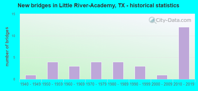
- New bridges - historical statistics
- 11940-1949
- 41950-1959
- 31960-1969
- 41970-1979
- 41980-1989
- 31990-1999
- 12000-2009
- 122010-2019

- Reconstructed bridges - Historical Statistics
- 11950-1959
- 01960-1969
- 01970-1979
- 01980-1989
- 11990-1999


- Bridge Condition - Deck
- 70.6%Good
- 29.4%Satisfactory

- Bridge Condition - Superstructure
- 5.9%Very good
- 58.8%Good
- 35.3%Satisfactory

- Bridge Condition - Substructure
- 82.4%Good
- 11.8%Satisfactory
- 5.9%Fair

- Bridge Condition - Channel
- 3.6%Very good
- 25.0%Good
- 71.4%Satisfactory

- Bridge Condition - Culverts
- 46.2%Good
- 53.8%Satisfactory
Find on map >> Show street view
Structure Number: 90140018501013, Location: 3.55 MI SE OF SH 95 (Lat: 31.011500, Lng: -97.300900), Route carried "on" structure: US 190, Year Built: 2010, Status: Open, Structure Length: 1.04m (3.41ft), Average Daily Traffic: 11,663 (year 2020), Truck Traffic: 24%, Average Future Daily Traffic: 14,180 (year 2035), Design Load: HS 20, Features Intersected: KNOB CREEK BRANCH
Minimum Vertical Clearance: 30+ m (98+ ft), Kilometerpoint: 7.594, Lanes on structure: 4, Base Highway Network: Yes, Owner: State Highway Agency, Approaching Roadway Width: 27.7m (90.9ft), Skew: 1 degrees, Material/Design: Concrete, Design/Construction: Culvert, Number Of Spans In Main Unit: 3, Length of Maximum Span: 3.0m (9.8ft)
Condition: Channel: Satisfactory, Culverts: Satisfactory, Operating Rating: 54.4 metric tons, Method Used To Determine Operating Rating: Assigned rating based on Load Factor Design (LFD) reported in metric tons, Inventory Rating: 32.7 metric tons, Method Used To Determine Inventory Rating: Assigned rating based on Load Factor Design (LFD) reported in metric tons, Structural Evaluation: Equal to present minimum criteria, Waterway Adequacy: Equal to present minimum criteria, Approach Roadway Alignment: Equal to present desirable criteria, Designated Inspection Frequency: Every 24 months, Inspection Date: Febuary 2021
Find on map >> Show street view
Structure Number: 90140018501014, Location: 3.85 MI SE OF SH 95 (Lat: 31.009050, Lng: -97.296900), Route carried "on" structure: US 190, Year Built: 2010, Status: Open, Structure Length: 1.71m (5.61ft), Average Daily Traffic: 11,663 (year 2020), Truck Traffic: 24%, Average Future Daily Traffic: 14,180 (year 2035), Design Load: HS 20, Features Intersected: KNOB CREEK BRANCH
Minimum Vertical Clearance: 30+ m (98+ ft), Kilometerpoint: 8.076, Lanes on structure: 6, Base Highway Network: Yes, Owner: State Highway Agency, Approaching Roadway Width: 29.6m (97.1ft), Skew: 3 degrees, Material/Design: Concrete, Design/Construction: Culvert, Number Of Spans In Main Unit: 5, Length of Maximum Span: 2.4m (7.9ft)
Condition: Channel: Satisfactory, Culverts: Good, Operating Rating: 54.4 metric tons, Method Used To Determine Operating Rating: Assigned rating based on Load Factor Design (LFD) reported in metric tons, Inventory Rating: 32.7 metric tons, Method Used To Determine Inventory Rating: Assigned rating based on Load Factor Design (LFD) reported in metric tons, Structural Evaluation: Better than present minimum criteria, Waterway Adequacy: Equal to present minimum criteria, Approach Roadway Alignment: Equal to present desirable criteria, Designated Inspection Frequency: Every 24 months, Inspection Date: Febuary 2021
Find on map >> Show street view
Structure Number: 90140018501019, Location: 4.24 MI SE OF SH 95 (Lat: 31.004700, Lng: -97.292500), Route carried "on" structure: US 190, Year Built: 2010, Status: Open, Structure Length: 0.82m (2.69ft), Average Daily Traffic: 11,663 (year 2020), Truck Traffic: 24%, Average Future Daily Traffic: 14,070 (year 2035), Design Load: HS 20, Features Intersected: KNOB CREEK BRANCH
Minimum Vertical Clearance: 30+ m (98+ ft), Kilometerpoint: 8.711, Lanes on structure: 4, Owner: State Highway Agency, Approaching Roadway Width: 23.5m (77.1ft), Skew: 1 degrees, Material/Design: Concrete, Design/Construction: Culvert, Number Of Spans In Main Unit: 3, Length of Maximum Span: 2.1m (6.9ft)
Condition: Channel: Satisfactory, Culverts: Good, Operating Rating: 54.4 metric tons, Method Used To Determine Operating Rating: Assigned rating based on Load Factor Design (LFD) reported in metric tons, Inventory Rating: 32.7 metric tons, Method Used To Determine Inventory Rating: Assigned rating based on Load Factor Design (LFD) reported in metric tons, Structural Evaluation: Better than present minimum criteria, Waterway Adequacy: Equal to present minimum criteria, Approach Roadway Alignment: Equal to present desirable criteria, Designated Inspection Frequency: Every 24 months, Inspection Date: Febuary 2021
Find on map >> Show street view
Structure Number: 90140018501035, Location: 0.92 MI SE OF FM 93 (Lat: 31.014556, Lng: -97.306722), Route carried "on" structure: US 190, Year Built: 2010, Status: Open, Structure Length: 10.82m (35.50ft), Average Daily Traffic: 4,680 (year 2015), Truck Traffic: 19%, Average Future Daily Traffic: 6,550 (year 2035), Design Load: HS 20, Features Intersected: FM 436
Minimum Vertical Clearance: 30+ m (98+ ft), Kilometerpoint: 3.578, Lanes on structure: 2, Lanes under structure: 4, Owner: State Highway Agency, Approaching Roadway Width: 11.6m (38.1ft), Skew: 2 degrees, Material/Design: Prestressed concrete, Design/Construction: Stringer/Multi-beam, Number Of Spans In Main Unit: 3, Length of Maximum Span: 38.1m (125.0ft), Curb-To-Curb Width: 11.6m (38.1ft), Out-to-Out Width: 12.2m (40.0ft)
Condition: Deck: Good, Superstructure: Good, Substructure: Good, Operating Rating: 54.4 metric tons, Method Used To Determine Operating Rating: Assigned rating based on Load Factor Design (LFD) reported in metric tons, Inventory Rating: 32.7 metric tons, Method Used To Determine Inventory Rating: Assigned rating based on Load Factor Design (LFD) reported in metric tons, Structural Evaluation: Better than present minimum criteria, Deck Geometry: Better than present minimum criteria, Underclear: Superior to present desirable criteria, Approach Roadway Alignment: Equal to present desirable criteria, Designated Inspection Frequency: Every 24 months, Inspection Date: March 2021, Deck Structure Type: Concrete Precast Panels
Find on map >> Show street view
Structure Number: 90140018501037, Location: 3.25 MI SE of SH 95 (Lat: 31.013633, Lng: -97.305283), Route carried "on" structure: US 190, Year Built: 2010, Status: Open, Structure Length: 7.16m (23.49ft), Average Daily Traffic: 4,680 (year 2015), Truck Traffic: 19%, Average Future Daily Traffic: 6,550 (year 2035), Design Load: HS 20, Features Intersected: MARGIE LOU BRANCH
Minimum Vertical Clearance: 30+ m (98+ ft), Kilometerpoint: 7.117, Lanes on structure: 2, Owner: State Highway Agency, Approaching Roadway Width: 12.2m (40.0ft), Skew: 3 degrees, Material/Design: Prestressed concrete, Design/Construction: Stringer/Multi-beam, Number Of Spans In Main Unit: 2, Length of Maximum Span: 38.1m (125.0ft), Curb-To-Curb Width: 11.6m (38.1ft), Out-to-Out Width: 12.2m (40.0ft)
Condition: Deck: Good, Superstructure: Good, Substructure: Good, Channel: Good, Operating Rating: 54.4 metric tons, Method Used To Determine Operating Rating: Assigned rating based on Load Factor Design (LFD) reported in metric tons, Inventory Rating: 32.7 metric tons, Method Used To Determine Inventory Rating: Assigned rating based on Load Factor Design (LFD) reported in metric tons, Structural Evaluation: Better than present minimum criteria, Deck Geometry: Better than present minimum criteria, Waterway Adequacy: Superior to present desirable criteria, Approach Roadway Alignment: Equal to present desirable criteria, Designated Inspection Frequency: Every 24 months, Inspection Date: March 2021, Deck Structure Type: Concrete Precast Panels
Find on map >> Show street view
Structure Number: 90140018501039, Location: 3.25 MI SE OF SH 95 (Lat: 31.012781, Lng: -97.304900), Route carried "on" structure: Ramp US 190, Year Built: 2010, Status: Open, Structure Length: 1.89m (6.20ft), Average Daily Traffic: 501 (year 2015), Truck Traffic: 19%, Average Future Daily Traffic: 760 (year 2035), Design Load: HS 20, Features Intersected: MARGIE LOU BRANCH
Minimum Vertical Clearance: 30+ m (98+ ft), Kilometerpoint: 7.117, Lanes on structure: 1, Base Highway Network: Yes, Owner: State Highway Agency, Approaching Roadway Width: 11.0m (36.1ft), Skew: 3 degrees, Material/Design: Concrete, Design/Construction: Culvert, Number Of Spans In Main Unit: 5, Length of Maximum Span: 3.0m (9.8ft)
Condition: Channel: Satisfactory, Culverts: Satisfactory, Operating Rating: 54.4 metric tons, Method Used To Determine Operating Rating: Assigned rating based on Load Factor Design (LFD) reported in metric tons, Inventory Rating: 32.7 metric tons, Method Used To Determine Inventory Rating: Assigned rating based on Load Factor Design (LFD) reported in metric tons, Structural Evaluation: Equal to present minimum criteria, Waterway Adequacy: Equal to present minimum criteria, Approach Roadway Alignment: Equal to present desirable criteria, Designated Inspection Frequency: Every 24 months, Inspection Date: Febuary 2021
Find on map >> Show street view
Structure Number: 9014001850104, Location: 3.25 MI SE OF SH 95 (Lat: 31.014169, Lng: -97.304889), Route carried "on" structure: Ramp US 190, Year Built: 2010, Status: Open, Structure Length: 1.89m (6.20ft), Average Daily Traffic: 501 (year 2015), Truck Traffic: 19%, Average Future Daily Traffic: 790 (year 2035), Design Load: HS 20, Features Intersected: MARGIE LOU BRANCH
Minimum Vertical Clearance: 30+ m (98+ ft), Kilometerpoint: 7.117, Lanes on structure: 2, Base Highway Network: Yes, Owner: State Highway Agency, Approaching Roadway Width: 12.2m (40.0ft), Skew: 3 degrees, Material/Design: Concrete, Design/Construction: Culvert, Number Of Spans In Main Unit: 5, Length of Maximum Span: 3.0m (9.8ft)
Condition: Channel: Satisfactory, Culverts: Satisfactory, Operating Rating: 54.4 metric tons, Method Used To Determine Operating Rating: Assigned rating based on Load Factor Design (LFD) reported in metric tons, Inventory Rating: 32.7 metric tons, Method Used To Determine Inventory Rating: Assigned rating based on Load Factor Design (LFD) reported in metric tons, Structural Evaluation: Equal to present minimum criteria, Waterway Adequacy: Equal to present minimum criteria, Approach Roadway Alignment: Equal to present desirable criteria, Designated Inspection Frequency: Every 24 months, Inspection Date: Febuary 2021
Find on map >> Show street view
Structure Number: 90140018501042, Location: 0.92 MI SE OF FM 93 (Lat: 31.014861, Lng: -97.306639), Route carried "on" structure: US 190, Year Built: 2010, Status: Open, Structure Length: 10.82m (35.50ft), Average Daily Traffic: 4,680 (year 2015), Truck Traffic: 19%, Average Future Daily Traffic: 6,550 (year 2035), Design Load: HS 20, Features Intersected: FM 436
Minimum Vertical Clearance: 30+ m (98+ ft), Kilometerpoint: 24.703, Lanes on structure: 2, Lanes under structure: 4, Owner: State Highway Agency, Approaching Roadway Width: 11.6m (38.1ft), Skew: 2 degrees, Material/Design: Prestressed concrete, Design/Construction: Stringer/Multi-beam, Number Of Spans In Main Unit: 3, Length of Maximum Span: 38.1m (125.0ft), Curb-To-Curb Width: 11.6m (38.1ft), Out-to-Out Width: 12.2m (40.0ft)
Condition: Deck: Good, Superstructure: Good, Substructure: Good, Operating Rating: 54.4 metric tons, Method Used To Determine Operating Rating: Assigned rating based on Load Factor Design (LFD) reported in metric tons, Inventory Rating: 32.7 metric tons, Method Used To Determine Inventory Rating: Assigned rating based on Load Factor Design (LFD) reported in metric tons, Structural Evaluation: Better than present minimum criteria, Deck Geometry: Better than present minimum criteria, Underclear: Superior to present desirable criteria, Approach Roadway Alignment: Equal to present desirable criteria, Designated Inspection Frequency: Every 24 months, Inspection Date: March 2021, Deck Structure Type: Concrete Precast Panels
Find on map >> Show street view
Structure Number: 90140018501044, Location: 3.25 MI SE of SH 95 (Lat: 31.013867, Lng: -97.305267), Route carried "on" structure: US 190, Year Built: 2010, Status: Open, Structure Length: 7.16m (23.49ft), Average Daily Traffic: 4,680 (year 2015), Truck Traffic: 19%, Average Future Daily Traffic: 6,550 (year 2035), Design Load: HS 20, Features Intersected: MARGIE LOU BRANCH
Minimum Vertical Clearance: 30+ m (98+ ft), Kilometerpoint: 7.117, Lanes on structure: 2, Owner: State Highway Agency, Approaching Roadway Width: 12.2m (40.0ft), Skew: 3 degrees, Material/Design: Prestressed concrete, Design/Construction: Stringer/Multi-beam, Number Of Spans In Main Unit: 2, Length of Maximum Span: 38.1m (125.0ft), Curb-To-Curb Width: 11.6m (38.1ft), Out-to-Out Width: 12.2m (40.0ft)
Condition: Deck: Good, Superstructure: Good, Substructure: Good, Channel: Good, Operating Rating: 54.4 metric tons, Method Used To Determine Operating Rating: Assigned rating based on Load Factor Design (LFD) reported in metric tons, Inventory Rating: 32.7 metric tons, Method Used To Determine Inventory Rating: Assigned rating based on Load Factor Design (LFD) reported in metric tons, Structural Evaluation: Better than present minimum criteria, Deck Geometry: Better than present minimum criteria, Waterway Adequacy: Superior to present desirable criteria, Approach Roadway Alignment: Equal to present desirable criteria, Designated Inspection Frequency: Every 24 months, Inspection Date: March 2021, Deck Structure Type: Concrete Precast Panels
Find on map >> Show street view
Structure Number: 9014002311605, Location: 0.20 MI SW OF US 190 (Lat: 31.015908, Lng: -97.305644), Route carried "on" structure: State highway 436, Year Built: 1953, Status: Open, Structure Length: 0.91m (2.99ft), Average Daily Traffic: 434 (year 2020), Truck Traffic: 21%, Average Future Daily Traffic: 490 (year 2033), Features Intersected: MARGIE LOU BRANCH
Minimum Vertical Clearance: 30+ m (98+ ft), Kilometerpoint: 37.358, Lanes on structure: 2, Owner: State Highway Agency, Approaching Roadway Width: 7.3m (24.0ft), Material/Design: Concrete, Design/Construction: Culvert, Number Of Spans In Main Unit: 3, Length of Maximum Span: 2.7m (8.9ft), Curb-To-Curb Width: 7.2m (23.6ft), Out-to-Out Width: 9.5m (31.2ft)
Condition: Channel: Good, Culverts: Satisfactory, Operating Rating: 39.9 metric tons, Method Used To Determine Operating Rating: Load Factor (LF), Inventory Rating: 23.6 metric tons, Method Used To Determine Inventory Rating: Load Factor (LF), Structural Evaluation: Equal to present minimum criteria, Deck Geometry: Meets minimum limits, Waterway Adequacy: Equal to present minimum criteria, Approach Roadway Alignment: Equal to present desirable criteria, Length Of Structure Improvement: 1.83m (6.00ft), Designated Inspection Frequency: Every 24 months, Inspection Date: April 2021, Bridge Improvement Cost: $174,000, Roadway Improvement Cost: $43,000, Total Project Cost: $261,000, Deck Structure Type: Concrete Cast-file-Place, Wearing Surface/Protective System: Wearing Surface: Bituminous
Find on map >> Show street view
Structure Number: 90140023116052, Location: 0.7 MI E OF SH 95 (Lat: 30.980231, Lng: -97.330186), Route carried "on" structure: State highway 436, Year Built: 1953, Year Reconstructed: 2004, Status: Open, Structure Length: 0.67m (2.20ft), Average Daily Traffic: 1,643 (year 2019), Truck Traffic: 22%, Average Future Daily Traffic: 1,780 (year 2033), Features Intersected: BR BOGGY CREEK
Minimum Vertical Clearance: 30+ m (98+ ft), Kilometerpoint: 31.991, Lanes on structure: 2, Owner: State Highway Agency, Approaching Roadway Width: 7.3m (24.0ft), Material/Design: Concrete, Design/Construction: Culvert, Number Of Spans In Main Unit: 2, Length of Maximum Span: 3.0m (9.8ft), Curb-To-Curb Width: 8.5m (27.9ft), Out-to-Out Width: 14.5m (47.6ft)
Condition: Channel: Satisfactory, Culverts: Good, Operating Rating: 39.9 metric tons, Method Used To Determine Operating Rating: Load Factor (LF), Inventory Rating: 23.6 metric tons, Method Used To Determine Inventory Rating: Load Factor (LF), Structural Evaluation: Equal to present minimum criteria, Deck Geometry: Somewhat better than minimum adequacy, Waterway Adequacy: Equal to present minimum criteria, Approach Roadway Alignment: Equal to present desirable criteria, Length Of Structure Improvement: 1.83m (6.00ft), Designated Inspection Frequency: Every 24 months, Inspection Date: April 2021, Bridge Improvement Cost: $174,000, Roadway Improvement Cost: $43,000, Total Project Cost: $261,000, Deck Structure Type: Concrete Cast-file-Place, Wearing Surface/Protective System: Wearing Surface: Bituminous
Find on map >> Show street view
Structure Number: 90140023116053, Location: 0.25 MI E OF SH 95 (Lat: 30.979508, Lng: -97.337522), Route carried "on" structure: State highway 436, Year Built: 1953, Status: Open, Structure Length: 3.05m (10.01ft), Average Daily Traffic: 1,643 (year 2019), Truck Traffic: 22%, Average Future Daily Traffic: 1,780 (year 2033), Design Load: H 15, Features Intersected: BOGGY CREEK
Minimum Vertical Clearance: 30+ m (98+ ft), Kilometerpoint: 31.303, Lanes on structure: 2, Owner: State Highway Agency, Approaching Roadway Width: 6.7m (22.0ft), Material/Design: Concrete, Design/Construction: Slab, Number Of Spans In Main Unit: 4, Length of Maximum Span: 7.6m (24.9ft), Curb-To-Curb Width: 7.3m (24.0ft), Out-to-Out Width: 7.7m (25.3ft)
Condition: Deck: Satisfactory, Superstructure: Satisfactory, Substructure: Fair, Channel: Satisfactory, Operating Rating: 49.0 metric tons, Method Used To Determine Operating Rating: Load Factor (LF), Inventory Rating: 25.4 metric tons, Method Used To Determine Inventory Rating: Load Factor (LF), Structural Evaluation: Somewhat better than minimum adequacy, Deck Geometry: Meets minimum limits, Waterway Adequacy: Equal to present minimum criteria, Approach Roadway Alignment: Equal to present desirable criteria, Length Of Structure Improvement: 3.81m (12.50ft), Designated Inspection Frequency: Every 24 months, Inspection Date: April 2021, Bridge Improvement Cost: $363,000, Roadway Improvement Cost: $90,000, Total Project Cost: $545,000, Deck Structure Type: Concrete Cast-file-Place, Wearing Surface/Protective System: Wearing Surface: Bituminous
Find on map >> Show street view
Structure Number: 90140023116057, Location: 2.10 MI W OF SH 95 (Lat: 30.992497, Lng: -97.375861), Route carried "on" structure: State highway 436, Year Built: 1960, Status: Open, Structure Length: 1.16m (3.81ft), Average Daily Traffic: 2,592 (year 2015), Truck Traffic: 14%, Average Future Daily Traffic: 4,100 (year 2033), Features Intersected: BR BOGGY CRK
Minimum Vertical Clearance: 30+ m (98+ ft), Kilometerpoint: 27.409, Lanes on structure: 2, Owner: State Highway Agency, Approaching Roadway Width: 10.7m (35.1ft), Skew: 3 degrees, Material/Design: Concrete, Design/Construction: Culvert, Number Of Spans In Main Unit: 3, Length of Maximum Span: 3.0m (9.8ft), Curb-To-Curb Width: 12.2m (40.0ft), Out-to-Out Width: 12.6m (41.3ft)
Condition: Channel: Satisfactory, Culverts: Good, Operating Rating: 39.9 metric tons, Method Used To Determine Operating Rating: Load Factor (LF), Inventory Rating: 23.6 metric tons, Method Used To Determine Inventory Rating: Load Factor (LF), Structural Evaluation: Equal to present minimum criteria, Deck Geometry: Equal to present minimum criteria, Waterway Adequacy: Equal to present minimum criteria, Approach Roadway Alignment: Equal to present desirable criteria, Length Of Structure Improvement: 1.83m (6.00ft), Designated Inspection Frequency: Every 24 months, Inspection Date: April 2021, Bridge Improvement Cost: $174,000, Roadway Improvement Cost: $43,000, Total Project Cost: $261,000, Deck Structure Type: Concrete Cast-file-Place, Wearing Surface/Protective System: Wearing Surface: Bituminous
Find on map >> Show street view
Structure Number: 90140023116058, Location: 0.9 MI W OF SH 95 (Lat: 30.986081, Lng: -97.356650), Route carried "on" structure: State highway 436, Year Built: 1960, Status: Open, Structure Length: 1.40m (4.59ft), Average Daily Traffic: 4,339 (year 2020), Truck Traffic: 14%, Average Future Daily Traffic: 4,910 (year 2033), Features Intersected: BR BOGGY CREEK
Minimum Vertical Clearance: 30+ m (98+ ft), Kilometerpoint: 29.411, Lanes on structure: 2, Owner: State Highway Agency, Approaching Roadway Width: 7.9m (25.9ft), Skew: 4 degrees, Material/Design: Concrete, Design/Construction: Culvert, Number Of Spans In Main Unit: 3, Length of Maximum Span: 3.0m (9.8ft), Curb-To-Curb Width: 8.8m (28.9ft), Out-to-Out Width: 15.0m (49.2ft)
Condition: Channel: Good, Culverts: Good, Operating Rating: 39.9 metric tons, Method Used To Determine Operating Rating: Load Factor (LF), Inventory Rating: 23.6 metric tons, Method Used To Determine Inventory Rating: Load Factor (LF), Structural Evaluation: Equal to present minimum criteria, Deck Geometry: Meets minimum limits, Waterway Adequacy: Equal to present minimum criteria, Approach Roadway Alignment: Equal to present desirable criteria, Length Of Structure Improvement: 1.83m (6.00ft), Designated Inspection Frequency: Every 24 months, Inspection Date: April 2021, Bridge Improvement Cost: $174,000, Roadway Improvement Cost: $43,000, Total Project Cost: $261,000, Deck Structure Type: Concrete Cast-file-Place, Wearing Surface/Protective System: Wearing Surface: Bituminous
Find on map >> Show street view
Structure Number: 90140023116134, Location: 1.90 MI S OF US 190 (Lat: 30.993564, Lng: -97.313956), Route carried "on" structure: State highway 436, Year Built: 1994, Status: Open, Structure Length: 5.21m (17.09ft), Average Daily Traffic: 434 (year 2020), Truck Traffic: 21%, Average Future Daily Traffic: 490 (year 2035), Design Load: HS 20, Features Intersected: KNOB CREEK
Minimum Vertical Clearance: 30+ m (98+ ft), Kilometerpoint: 34.728, Lanes on structure: 2, Owner: State Highway Agency, Approaching Roadway Width: 9.1m (29.9ft), Skew: 4 degrees, Material/Design: Concrete, Design/Construction: Stringer/Multi-beam, Number Of Spans In Main Unit: 5, Length of Maximum Span: 10.4m (34.1ft), Curb-To-Curb Width: 8.9m (29.2ft), Out-to-Out Width: 9.8m (32.2ft)
Condition: Deck: Good, Superstructure: Good, Substructure: Good, Channel: Good, Operating Rating: 49.0 metric tons, Method Used To Determine Operating Rating: Load Factor (LF), Inventory Rating: 29.0 metric tons, Method Used To Determine Inventory Rating: Load Factor (LF), Structural Evaluation: Better than present minimum criteria, Deck Geometry: Somewhat better than minimum adequacy, Waterway Adequacy: Superior to present desirable criteria, Approach Roadway Alignment: Equal to present desirable criteria, Length Of Structure Improvement: 7.32m (24.02ft), Designated Inspection Frequency: Every 24 months, Inspection Date: Febuary 2021, Bridge Improvement Cost: $696,000, Roadway Improvement Cost: $174,000, Total Project Cost: $1,044,000, Deck Structure Type: Concrete Cast-file-Place
Find on map >> Show street view
Structure Number: 90140023116393, Location: 6.0 MI E OF IH 35 (Lat: 30.993500, Lng: -97.393889), Route carried "on" structure: State highway 436, Year Built: 2016, Status: Open, Structure Length: 8.29m (27.20ft), Average Daily Traffic: 2,592 (year 2015), Truck Traffic: 14%, Average Future Daily Traffic: 4,100 (year 2033), Design Load: HL 93, Features Intersected: LEON RIVER
Minimum Vertical Clearance: 30+ m (98+ ft), Kilometerpoint: 25.523, Lanes on structure: 2, Owner: State Highway Agency, Approaching Roadway Width: 12.2m (40.0ft), Material/Design: Prestressed concrete, Design/Construction: Stringer/Multi-beam, Number Of Spans In Main Unit: 1, Number Of Approach Spans: 2, Length of Maximum Span: 40.2m (131.9ft), Curb-To-Curb Width: 12.1m (39.7ft), Out-to-Out Width: 12.8m (42.0ft)
Condition: Deck: Good, Superstructure: Very good, Substructure: Good, Channel: Satisfactory, Operating Rating: 54.4 metric tons, Method Used To Determine Operating Rating: Assigned ratings based on Load and Resistance Factor Design (LRFD) reported in metric tons, Inventory Rating: 32.7 metric tons, Method Used To Determine Inventory Rating: Assigned ratings based on Load and Resistance Factor Design (LRFD) reported in metric tons, Structural Evaluation: Better than present minimum criteria, Deck Geometry: Somewhat better than minimum adequacy, Waterway Adequacy: Superior to present desirable criteria, Approach Roadway Alignment: Equal to present desirable criteria, Designated Inspection Frequency: Every 24 months, Inspection Date: April 2021, Deck Structure Type: Concrete Precast Panels
Find on map >> Show street view
Structure Number: 90140032001047, Location: 1.10 MI N OF FM 436 (Lat: 30.996239, Lng: -97.339769), Route carried "on" structure: State highway 95, Year Built: 1948, Year Reconstructed: 1959, Status: Open, Structure Length: 3.72m (12.20ft), Average Daily Traffic: 6,885 (year 2015), Truck Traffic: 7%, Average Future Daily Traffic: 8,810 (year 2033), Features Intersected: BOGGY CREEK
Minimum Vertical Clearance: 30+ m (98+ ft), Kilometerpoint: 28.347, Lanes on structure: 2, Owner: State Highway Agency, Approaching Roadway Width: 13.1m (43.0ft), Skew: 3 degrees, Material/Design: Steel, Design/Construction: Stringer/Multi-beam, Number Of Spans In Main Unit: 3, Length of Maximum Span: 12.2m (40.0ft), Curb-To-Curb Width: 13.3m (43.6ft), Out-to-Out Width: 13.8m (45.3ft)
Condition: Deck: Good, Superstructure: Satisfactory, Substructure: Good, Channel: Satisfactory, Operating Rating: 40.8 metric tons, Method Used To Determine Operating Rating: Load Factor (LF), Inventory Rating: 24.5 metric tons, Method Used To Determine Inventory Rating: Load Factor (LF), Structural Evaluation: Equal to present minimum criteria, Deck Geometry: Somewhat better than minimum adequacy, Waterway Adequacy: Equal to present minimum criteria, Approach Roadway Alignment: Equal to present desirable criteria, Length Of Structure Improvement: 4.57m (14.99ft), Designated Inspection Frequency: Every 24 months, Inspection Date: April 2021, Bridge Improvement Cost: $436,000, Roadway Improvement Cost: $109,000, Total Project Cost: $654,000, Deck Structure Type: Concrete Cast-file-Place, Wearing Surface/Protective System: Wearing Surface: Bituminous
Find on map >> Show street view
Structure Number: 90140032002049, Location: 3.40 MI S OF FM 436 (Lat: 30.932983, Lng: -97.358061), Route carried "on" structure: State highway 95, Year Built: 1950, Status: Open, Structure Length: 6.13m (20.11ft), Average Daily Traffic: 4,494 (year 2020), Truck Traffic: 4%, Average Future Daily Traffic: 7,130 (year 2035), Features Intersected: WILLOW CREEK
Minimum Vertical Clearance: 30+ m (98+ ft), Kilometerpoint: 4.706, Lanes on structure: 2, Owner: State Highway Agency, Approaching Roadway Width: 11.6m (38.1ft), Material/Design: Steel, Design/Construction: Stringer/Multi-beam, Number Of Spans In Main Unit: 5, Length of Maximum Span: 12.2m (40.0ft), Curb-To-Curb Width: 7.9m (25.9ft), Out-to-Out Width: 8.9m (29.2ft)
Condition: Deck: Satisfactory, Superstructure: Satisfactory, Substructure: Satisfactory, Channel: Satisfactory, Operating Rating: 41.7 metric tons, Method Used To Determine Operating Rating: Load Factor (LF), Inventory Rating: 24.5 metric tons, Method Used To Determine Inventory Rating: Load Factor (LF), Structural Evaluation: Equal to present minimum criteria, Deck Geometry: High priority of corrective action, Waterway Adequacy: Equal to present minimum criteria, Approach Roadway Alignment: Equal to present desirable criteria, Length Of Structure Improvement: 8.23m (27.00ft), Designated Inspection Frequency: Every 24 months, Inspection Date: Febuary 2021, Bridge Improvement Cost: $903,000, Roadway Improvement Cost: $225,000, Total Project Cost: $1,355,000, Deck Structure Type: Concrete Cast-file-Place, Wearing Surface/Protective System: Wearing Surface: Bituminous
Find on map >> Show street view
Structure Number: 901400320021, Location: 4.1 MILE S OF FM 93 (Lat: 30.972569, Lng: -97.344458), Route carried "on" structure: State highway 195, Year Built: 2007, Status: Open, Structure Length: 83.58m (274.21ft), Average Daily Traffic: 5,249 (year 2020), Truck Traffic: 9%, Average Future Daily Traffic: 46,300 (year 2030), Design Load: HS 20, Features Intersected: LITTLE RIVER, Facility Carried by Structure: SH 95
Minimum Vertical Clearance: 30+ m (98+ ft), Kilometerpoint: 0.414, Lanes on structure: 2, Owner: State Highway Agency, Approaching Roadway Width: 13.4m (44.0ft), Material/Design: Prestressed concrete, Design/Construction: Stringer/Multi-beam, Number Of Spans In Main Unit: 1, Number Of Approach Spans: 33, Length of Maximum Span: 35.4m (116.1ft), Curb-To-Curb Width: 13.4m (44.0ft), Out-to-Out Width: 14.0m (45.9ft)
Condition: Deck: Good, Superstructure: Good, Substructure: Satisfactory, Channel: Satisfactory, Operating Rating: 54.4 metric tons, Method Used To Determine Operating Rating: Assigned rating based on Load Factor Design (LFD) reported in metric tons, Inventory Rating: 32.7 metric tons, Method Used To Determine Inventory Rating: Assigned rating based on Load Factor Design (LFD) reported in metric tons, Structural Evaluation: Equal to present minimum criteria, Deck Geometry: Equal to present minimum criteria, Waterway Adequacy: Superior to present desirable criteria, Approach Roadway Alignment: Equal to present desirable criteria, Designated Inspection Frequency: Every 24 months, Inspection Date: April 2021, Deck Structure Type: Concrete Precast Panels
Find on map >> Show street view
Structure Number: 90140329201002, Location: 0.45 MI E OF SH 95 (Lat: 31.027806, Lng: -97.325425), Route carried "on" structure: State highway 93, Year Built: 1975, Status: Open, Structure Length: 1.80m (5.91ft), Average Daily Traffic: 3,528 (year 2020), Truck Traffic: 22%, Average Future Daily Traffic: 3,770 (year 2033), Design Load: HS 20, Features Intersected: KNOB CREEK
Minimum Vertical Clearance: 30+ m (98+ ft), Kilometerpoint: 28.751, Lanes on structure: 2, Owner: State Highway Agency, Approaching Roadway Width: 10.4m (34.1ft), Material/Design: Concrete, Design/Construction: Culvert, Number Of Spans In Main Unit: 6, Length of Maximum Span: 2.7m (8.9ft), Curb-To-Curb Width: 10.4m (34.1ft), Out-to-Out Width: 13.2m (43.3ft)
Condition: Channel: Satisfactory, Culverts: Good, Operating Rating: 39.9 metric tons, Method Used To Determine Operating Rating: Load Factor (LF), Inventory Rating: 23.6 metric tons, Method Used To Determine Inventory Rating: Load Factor (LF), Structural Evaluation: Equal to present minimum criteria, Deck Geometry: Somewhat better than minimum adequacy, Waterway Adequacy: Equal to present minimum criteria, Approach Roadway Alignment: Equal to present desirable criteria, Length Of Structure Improvement: 2.74m (8.99ft), Designated Inspection Frequency: Every 24 months, Inspection Date: April 2021, Bridge Improvement Cost: $261,000, Roadway Improvement Cost: $65,000, Total Project Cost: $392,000, Deck Structure Type: Concrete Cast-file-Place, Wearing Surface/Protective System: Wearing Surface: Bituminous
Find on map >> Show street view
Structure Number: 90140AA0296001, Location: 1.70 MI SE OF FM 436 (Lat: 30.965392, Lng: -97.304872), Route carried "on" structure: County highway , Year Built: 1976, Status: Open, Structure Length: 5.61m (18.41ft), Average Daily Traffic: 422 (year 2020), Average Future Daily Traffic: 100 (year 2026), Features Intersected: KNOB CRK #12, Facility Carried by Structure: REEDS LAKE RD
Minimum Vertical Clearance: 30+ m (98+ ft), Kilometerpoint: 2.736, Lanes on structure: 2, Owner: County Highway Agency, Approaching Roadway Width: 6.1m (20.0ft), Material/Design: Concrete, Design/Construction: Stringer/Multi-beam, Number Of Spans In Main Unit: 6, Length of Maximum Span: 9.1m (29.9ft), Curb-To-Curb Width: 7.1m (23.3ft), Out-to-Out Width: 7.6m (24.9ft)
Condition: Deck: Satisfactory, Superstructure: Good, Substructure: Good, Channel: Satisfactory, Operating Rating: 32.7 metric tons, Method Used To Determine Operating Rating: Field evaluation and documented engineering judgment, Inventory Rating: 24.5 metric tons, Method Used To Determine Inventory Rating: Field evaluation and documented engineering judgment, Structural Evaluation: Equal to present minimum criteria, Deck Geometry: Meets minimum limits, Waterway Adequacy: Better than present minimum criteria, Approach Roadway Alignment: Equal to present desirable criteria, Length Of Structure Improvement: 7.32m (24.02ft), Designated Inspection Frequency: Every 24 months, Inspection Date: November 2021, Bridge Improvement Cost: $670,000, Roadway Improvement Cost: $167,000, Total Project Cost: $1,100,000, Deck Structure Type: Concrete Cast-file-Place
Find on map >> Show street view
Structure Number: 90140AA0296002, Location: 2.40 MI SE OF REEDS LK RD (Lat: 30.954161, Lng: -97.301269), Route carried "on" structure: County highway , Year Built: 1985, Status: Open, Structure Length: 0.70m (2.30ft), Average Daily Traffic: 35 (year 2009), Average Future Daily Traffic: 50 (year 2026), Features Intersected: KNOB CRK TRIB #10, Facility Carried by Structure: REEDS LAKE LP
Minimum Vertical Clearance: 30+ m (98+ ft), Kilometerpoint: 3.862, Lanes on structure: 2, Owner: County Highway Agency, Approaching Roadway Width: 5.5m (18.0ft), Skew: 1 degrees, Material/Design: Concrete, Design/Construction: Culvert, Number Of Spans In Main Unit: 2, Length of Maximum Span: 3.0m (9.8ft), Curb-To-Curb Width: 7.0m (23.0ft), Out-to-Out Width: 7.4m (24.3ft)
Condition: Channel: Satisfactory, Culverts: Satisfactory, Operating Rating: 32.7 metric tons, Method Used To Determine Operating Rating: Field evaluation and documented engineering judgment, Inventory Rating: 24.5 metric tons, Method Used To Determine Inventory Rating: Field evaluation and documented engineering judgment, Structural Evaluation: Equal to present minimum criteria, Deck Geometry: Somewhat better than minimum adequacy, Waterway Adequacy: Equal to present minimum criteria, Approach Roadway Alignment: Equal to present desirable criteria, Length Of Structure Improvement: 1.83m (6.00ft), Designated Inspection Frequency: Every 24 months, Inspection Date: November 2021, Bridge Improvement Cost: $170,000, Roadway Improvement Cost: $41,000, Total Project Cost: $255,000, Deck Structure Type: Concrete Cast-file-Place, Wearing Surface/Protective System: Wearing Surface: Gravel
Find on map >> Show street view
Structure Number: 90140AA0296003, Location: 2.35 MI SE OF REEDS LK RD (Lat: 30.953906, Lng: -97.303600), Route carried "on" structure: County highway , Year Built: 1977, Status: Open, Structure Length: 1.65m (5.41ft), Average Daily Traffic: 100 (year 2015), Average Future Daily Traffic: 50 (year 2026), Features Intersected: KNOB CRK #11, Facility Carried by Structure: REEDS LAKE LP
Minimum Vertical Clearance: 30+ m (98+ ft), Kilometerpoint: 3.782, Lanes on structure: 2, Owner: County Highway Agency, Approaching Roadway Width: 5.5m (18.0ft), Material/Design: Concrete, Design/Construction: Culvert, Number Of Spans In Main Unit: 5, Length of Maximum Span: 3.0m (9.8ft), Curb-To-Curb Width: 6.9m (22.6ft), Out-to-Out Width: 7.3m (24.0ft)
Condition: Channel: Satisfactory, Culverts: Satisfactory, Operating Rating: 32.7 metric tons, Method Used To Determine Operating Rating: Field evaluation and documented engineering judgment, Inventory Rating: 24.5 metric tons, Method Used To Determine Inventory Rating: Field evaluation and documented engineering judgment, Structural Evaluation: Equal to present minimum criteria, Deck Geometry: Somewhat better than minimum adequacy, Waterway Adequacy: High priority of corrective action, Approach Roadway Alignment: Equal to present desirable criteria, Length Of Structure Improvement: 2.74m (8.99ft), Designated Inspection Frequency: Every 24 months, Inspection Date: November 2021, Bridge Improvement Cost: $250,000, Roadway Improvement Cost: $62,000, Total Project Cost: $375,000, Deck Structure Type: Concrete Cast-file-Place
Find on map >> Show street view
Structure Number: 90140AA0308001, Location: 1.25 MI S OF FM 93 (Lat: 31.016639, Lng: -97.323039), Route carried "on" structure: County highway , Year Built: 1993, Status: Open, Structure Length: 1.86m (6.10ft), Average Daily Traffic: 100 (year 2020), Average Future Daily Traffic: 75 (year 2026), Features Intersected: KNOB CRK #14, Facility Carried by Structure: KNOB CRK RD
Minimum Vertical Clearance: 30+ m (98+ ft), Kilometerpoint: 2.012, Lanes on structure: 2, Owner: County Highway Agency, Approaching Roadway Width: 6.1m (20.0ft), Material/Design: Concrete, Design/Construction: Stringer/Multi-beam, Number Of Spans In Main Unit: 2, Length of Maximum Span: 9.1m (29.9ft), Curb-To-Curb Width: 7.4m (24.3ft), Out-to-Out Width: 8.0m (26.2ft)
Condition: Deck: Good, Superstructure: Good, Substructure: Good, Channel: Good, Operating Rating: 32.7 metric tons, Method Used To Determine Operating Rating: Field evaluation and documented engineering judgment, Inventory Rating: 24.5 metric tons, Method Used To Determine Inventory Rating: Field evaluation and documented engineering judgment, Structural Evaluation: Equal to present minimum criteria, Deck Geometry: Equal to present minimum criteria, Waterway Adequacy: Better than present minimum criteria, Approach Roadway Alignment: Equal to present desirable criteria, Length Of Structure Improvement: 2.74m (8.99ft), Designated Inspection Frequency: Every 24 months, Inspection Date: November 2021, Bridge Improvement Cost: $251,000, Roadway Improvement Cost: $62,000, Total Project Cost: $313,000, Deck Structure Type: Concrete Cast-file-Place
Find on map >> Show street view
Structure Number: 90140AA0337005, Location: 2.20 MI SE OF FM 436 (Lat: 30.969561, Lng: -97.377319), Route carried "on" structure: County highway , Year Built: 1987, Status: Open, Structure Length: 0.91m (2.99ft), Average Daily Traffic: 120 (year 2009), Truck Traffic: 1%, Average Future Daily Traffic: 1,000 (year 2026), Features Intersected: LITTLE RI BR # 61, Facility Carried by Structure: WILSON VALLEY RD
Minimum Vertical Clearance: 30+ m (98+ ft), Kilometerpoint: 10.139, Lanes on structure: 2, Owner: Town or Township Highway Agency, Maintenance Responsibility: County Highway Agency, Approaching Roadway Width: 5.5m (18.0ft), Material/Design: Steel, Design/Construction: Stringer/Multi-beam, Number Of Spans In Main Unit: 1, Length of Maximum Span: 8.8m (28.9ft), Curb-To-Curb Width: 6.9m (22.6ft), Out-to-Out Width: 7.3m (24.0ft)
Condition: Deck: Good, Superstructure: Satisfactory, Substructure: Good, Channel: Very good, Operating Rating: 68.0 metric tons, Method Used To Determine Operating Rating: Allowable Stress (AS), Inventory Rating: 40.8 metric tons, Method Used To Determine Inventory Rating: Allowable Stress (AS), Structural Evaluation: Equal to present minimum criteria, Deck Geometry: Meets minimum limits, Waterway Adequacy: Meets minimum limits, Approach Roadway Alignment: Meets minimum limits, Length Of Structure Improvement: 1.83m (6.00ft), Designated Inspection Frequency: Every 24 months, Inspection Date: November 2021, Bridge Improvement Cost: $167,000, Roadway Improvement Cost: $41,000, Total Project Cost: $208,000, Deck Structure Type: Concrete Cast-file-Place
Find on map >> Show street view
Structure Number: 90140AA0361001, Location: 1.15 MI S OF FM 436 (Lat: 30.983994, Lng: -97.405317), Route carried "on" structure: County highway , Year Built: 1984, Status: Open, Structure Length: 7.32m (24.02ft), Average Daily Traffic: 310 (year 2015), Truck Traffic: 1%, Average Future Daily Traffic: 300 (year 2026), Design Load: HS 20, Features Intersected: LAMPASAS RI # 47, Facility Carried by Structure: DICE GROVE RD
Minimum Vertical Clearance: 30+ m (98+ ft), Kilometerpoint: 2.752, Lanes on structure: 2, Owner: County Highway Agency, Approaching Roadway Width: 6.7m (22.0ft), Material/Design: Prestressed concrete, Design/Construction: Stringer/Multi-beam, Number Of Spans In Main Unit: 3, Length of Maximum Span: 24.4m (80.1ft), Curb-To-Curb Width: 8.3m (27.2ft), Out-to-Out Width: 9.1m (29.9ft)
Condition: Deck: Good, Superstructure: Good, Substructure: Good, Channel: Satisfactory, Operating Rating: 54.4 metric tons, Method Used To Determine Operating Rating: Assigned rating based on Load Factor Design (LFD) reported in metric tons, Inventory Rating: 32.7 metric tons, Method Used To Determine Inventory Rating: Assigned rating based on Load Factor Design (LFD) reported in metric tons, Structural Evaluation: Better than present minimum criteria, Deck Geometry: Somewhat better than minimum adequacy, Waterway Adequacy: Superior to present desirable criteria, Approach Roadway Alignment: Meets minimum limits, Length Of Structure Improvement: 9.24m (30.31ft), Designated Inspection Frequency: Every 24 months, Inspection Date: November 2021, Bridge Improvement Cost: $845,000, Roadway Improvement Cost: $211,000, Total Project Cost: $1,056,000, Deck Structure Type: Concrete Cast-file-Place
Find on map >> Show street view
Structure Number: 90140AA0371001, Location: 0.10 MI E OF SULLIVAN RD (Lat: 30.926056, Lng: -97.342464), Route carried "on" structure: County highway , Year Built: 1975, Status: Posted for load, Structure Length: 1.83m (6.00ft), Average Daily Traffic: 100 (year 2015), Average Future Daily Traffic: 70 (year 2026), Features Intersected: WILLOW CRK #18, Facility Carried by Structure: VOLO RD
Minimum Vertical Clearance: 30+ m (98+ ft), Kilometerpoint: 0.161, Lanes on structure: 2, Owner: County Highway Agency, Approaching Roadway Width: 5.5m (18.0ft), Material/Design: Prestressed concrete, Number Of Spans In Main Unit: 2, Length of Maximum Span: 9.1m (29.9ft), Curb-To-Curb Width: 6.9m (22.6ft), Out-to-Out Width: 7.3m (24.0ft)
Condition: Deck: Satisfactory, Superstructure: Satisfactory, Substructure: Good, Channel: Good, Operating Rating: 29.9 metric tons, Method Used To Determine Operating Rating: Allowable Stress (AS), Inventory Rating: 20.9 metric tons, Method Used To Determine Inventory Rating: Allowable Stress (AS), Structural Evaluation: Equal to present minimum criteria, Deck Geometry: Somewhat better than minimum adequacy, Waterway Adequacy: Better than present minimum criteria, Approach Roadway Alignment: Equal to present desirable criteria, Bridge Posting: Required (Relationship of Operating Rating to Maximum Legal Load: 0.1 - 9.9% below), Length Of Structure Improvement: 2.74m (8.99ft), Designated Inspection Frequency: Every 24 months, Inspection Date: November 2021, Bridge Improvement Cost: $251,000, Roadway Improvement Cost: $62,000, Total Project Cost: $313,000, Deck Structure Type: Concrete Cast-file-Place
Find on map >> Show street view
Structure Number: 90140AA0381001, Location: 0.45 MI E OF SH 95 (Lat: 30.929639, Lng: -97.351217), Route carried "on" structure: County highway , Year Built: 1981, Status: Open, Structure Length: 1.16m (3.81ft), Average Daily Traffic: 210 (year 2009), Average Future Daily Traffic: 300 (year 2026), Features Intersected: RUNNELLS CRK #19, Facility Carried by Structure: SULLIVAN RD
Minimum Vertical Clearance: 30+ m (98+ ft), Kilometerpoint: 0.724, Lanes on structure: 2, Owner: County Highway Agency, Approaching Roadway Width: 6.7m (22.0ft), Skew: 3 degrees, Material/Design: Concrete, Design/Construction: Culvert, Number Of Spans In Main Unit: 3, Length of Maximum Span: 3.0m (9.8ft), Curb-To-Curb Width: 9.2m (30.2ft), Out-to-Out Width: 9.8m (32.2ft)
Condition: Channel: Satisfactory, Culverts: Satisfactory, Operating Rating: 32.7 metric tons, Method Used To Determine Operating Rating: Field evaluation and documented engineering judgment, Inventory Rating: 24.5 metric tons, Method Used To Determine Inventory Rating: Field evaluation and documented engineering judgment, Structural Evaluation: Equal to present minimum criteria, Deck Geometry: Equal to present minimum criteria, Waterway Adequacy: Better than present minimum criteria, Approach Roadway Alignment: Equal to present minimum criteria, Length Of Structure Improvement: 1.83m (6.00ft), Designated Inspection Frequency: Every 24 months, Inspection Date: November 2021, Bridge Improvement Cost: $167,000, Roadway Improvement Cost: $41,000, Total Project Cost: $208,000, Deck Structure Type: Concrete Cast-file-Place, Wearing Surface/Protective System: Wearing Surface: Bituminous
Find on map >> Show street view
Structure Number: 90140AA0801001, Location: 0.35 MI E OF FM 436 (Lat: 30.988636, Lng: -97.309556), Route carried "on" structure: County highway , Year Built: 1992, Status: Open, Structure Length: 1.65m (5.41ft), Average Daily Traffic: 100 (year 2015), Average Future Daily Traffic: 75 (year 2026), Features Intersected: KNOB CRK #13, Facility Carried by Structure: MARGIE LOU LN
Minimum Vertical Clearance: 30+ m (98+ ft), Kilometerpoint: 0.563, Lanes on structure: 1, Owner: County Highway Agency, Approaching Roadway Width: 4.9m (16.1ft), Material/Design: Steel, Number Of Spans In Main Unit: 1, Length of Maximum Span: 15.5m (50.9ft), Curb-To-Curb Width: 5.8m (19.0ft), Out-to-Out Width: 6.0m (19.7ft)
Condition: Deck: Satisfactory, Superstructure: Satisfactory, Substructure: Good, Channel: Satisfactory, Operating Rating: 58.0 metric tons, Method Used To Determine Operating Rating: Load Factor (LF), Inventory Rating: 34.5 metric tons, Method Used To Determine Inventory Rating: Load Factor (LF), Structural Evaluation: Equal to present minimum criteria, Deck Geometry: Meets minimum limits, Waterway Adequacy: Meets minimum limits, Approach Roadway Alignment: Equal to present desirable criteria, Length Of Structure Improvement: 2.74m (8.99ft), Designated Inspection Frequency: Every 24 months, Inspection Date: November 2021, Bridge Improvement Cost: $251,000, Roadway Improvement Cost: $62,000, Total Project Cost: $313,000, Deck Structure Type: Steel plate, Wearing Surface/Protective System: Wearing Surface: Gravel
Find on map >> Show street view
Structure Number: 90140B00010001, Location: 0.35 MI S OF FM 436 (Lat: 30.984456, Lng: -97.368958), Route carried "on" structure: City street , Year Built: 1960, Status: Open, Structure Length: 1.28m (4.20ft), Average Daily Traffic: 400 (year 2009), Truck Traffic: 1%, Average Future Daily Traffic: 700 (year 2026), Features Intersected: LITTLE RI TRIB #1 LRA, Facility Carried by Structure: S WILSON VALLEY DR
Minimum Vertical Clearance: 30+ m (98+ ft), Kilometerpoint: 8.208, Lanes on structure: 2, Owner: City or Municipal Highway Agency, Approaching Roadway Width: 5.5m (18.0ft), Material/Design: Concrete, Design/Construction: Stringer/Multi-beam, Number Of Spans In Main Unit: 1, Length of Maximum Span: 12.2m (40.0ft), Curb-To-Curb Width: 7.1m (23.3ft), Out-to-Out Width: 7.5m (24.6ft)
Condition: Deck: Good, Superstructure: Good, Substructure: Good, Channel: Satisfactory, Operating Rating: 32.7 metric tons, Method Used To Determine Operating Rating: Field evaluation and documented engineering judgment, Inventory Rating: 24.5 metric tons, Method Used To Determine Inventory Rating: Field evaluation and documented engineering judgment, Structural Evaluation: Equal to present minimum criteria, Deck Geometry: Meets minimum limits, Waterway Adequacy: High priority of corrective action, Approach Roadway Alignment: Equal to present desirable criteria, Length Of Structure Improvement: 1.83m (6.00ft), Designated Inspection Frequency: Every 24 months, Inspection Date: November 2021, Bridge Improvement Cost: $167,000, Roadway Improvement Cost: $41,000, Total Project Cost: $208,000, Deck Structure Type: Concrete Cast-file-Place, Wearing Surface/Protective System: Wearing Surface: Bituminous
Find on map >> Show street view
Structure Number: 90140018501035, Location: 0.92 MI SE OF FM 93 (Lat: 31.014556, Lng: -97.306722), Route carried "under" structure: State highway 436, Year Built: 2010, Structure Length: 0. m, Average Daily Traffic: 4,200 (year 2015), Truck Traffic: 9%, Features Intersected: FM 436, Facility Carried by Structure: US 190 EB
Minimum Vertical Clearance: 5.26m (17.26ft), Kilometerpoint: 0.000, Lanes on structure: 2, Lanes under structure: 4, Material/Design: Prestressed concrete, Design/Construction: Stringer/Multi-beam, Length of Maximum Span: 38.1m (125.0ft)
Find on map >> Show street view
Structure Number: 90140018501042, Location: 0.92 MI SE OF FM 93 (Lat: 31.014861, Lng: -97.306639), Route carried "under" structure: State highway 436, Year Built: 2010, Structure Length: 0. m, Average Daily Traffic: 4,200 (year 2015), Truck Traffic: 9%, Features Intersected: FM 436, Facility Carried by Structure: US 190 WB
Minimum Vertical Clearance: 5.26m (17.26ft), Kilometerpoint: 0.000, Lanes on structure: 2, Lanes under structure: 4, Material/Design: Prestressed concrete, Design/Construction: Stringer/Multi-beam, Length of Maximum Span: 38.1m (125.0ft)