Bridge Statistics for Littlefield, Arizona (AZ)
Condition, Traffic, Stress, Structural Evaluation, Project Costs
- National Bridge Inventory (NBI) Statistics
- 17Number of bridges
- 374ft / 114mTotal length
- $18,000Total costs
- 221,116Total average daily traffic
- 66,493Total average daily truck traffic
- National Bridge Inventory (NBI) Registered Bridges for Littlefield
- No street view available for this location
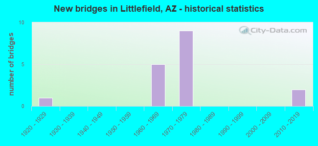
- New bridges - historical statistics
- 11920-1929
- 51960-1969
- 91970-1979
- 22010-2019
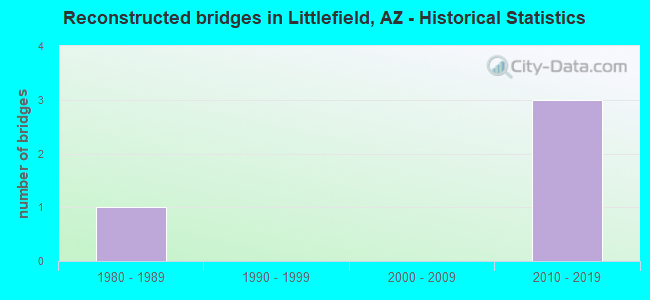
- Reconstructed bridges - Historical Statistics
- 11980-1989
- 01990-1999
- 02000-2009
- 32010-2019
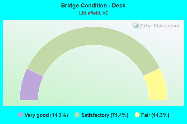
- Bridge Condition - Deck
- 14.3%Very good
- 71.4%Satisfactory
- 14.3%Fair
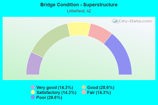
- Bridge Condition - Superstructure
- 14.3%Very good
- 28.6%Good
- 14.3%Satisfactory
- 14.3%Fair
- 28.6%Poor
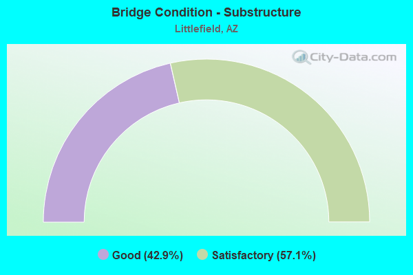
- Bridge Condition - Substructure
- 42.9%Good
- 57.1%Satisfactory
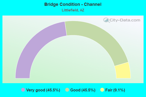
- Bridge Condition - Channel
- 45.5%Very good
- 45.5%Good
- 9.1%Fair
Find on map >> Show street view
Structure Number: 1612, Location: 8.6 mi E of Nevada (Lat: 36.891200, Lng: -113.929700), Route carried "on" structure: Interstate 15, Year Built: 1974, Status: Open, Structure Length: 4.66m (15.29ft), Average Daily Traffic: 9,872 (year 2017), Truck Traffic: 26%, Average Future Daily Traffic: 9,882 (year 2037), Design Load: HS 20, Features Intersected: Old US 91
Minimum Vertical Clearance: 30+ m (98+ ft), Kilometerpoint: 13.856, Lanes on structure: 2, Lanes under structure: 3, Owner: State Highway Agency, Approaching Roadway Width: 12.8m (42.0ft), Skew: 1 degrees, Material/Design: Prestressed concrete, Design/Construction: Box Beam or Girders - Single/Spread, Number Of Spans In Main Unit: 1, Length of Maximum Span: 46.0m (150.9ft), Curb-To-Curb Width: 12.8m (42.0ft), Out-to-Out Width: 13.6m (44.6ft)
Condition: Deck: Satisfactory, Superstructure: Good, Substructure: Good, Operating Rating: 68.9 metric tons, Method Used To Determine Operating Rating: Load Factor (LF), Inventory Rating: 40.8 metric tons, Method Used To Determine Inventory Rating: Load Factor (LF), Structural Evaluation: Better than present minimum criteria, Deck Geometry: Equal to present desirable criteria, Underclear: Superior to present desirable criteria, Approach Roadway Alignment: Equal to present minimum criteria, Designated Inspection Frequency: Every 24 months, Inspection Date: October 2020, Deck Structure Type: Concrete Cast-file-Place, Wearing Surface/Protective System: Wearing Surface: Monolithic Concrete
Find on map >> Show street view
Structure Number: 1613, Location: 8.6 mi E of Nevada (Lat: 36.891700, Lng: -113.929900), Route carried "on" structure: Interstate 15, Year Built: 1974, Status: Open, Structure Length: 4.66m (15.29ft), Average Daily Traffic: 9,164 (year 2017), Truck Traffic: 26%, Average Future Daily Traffic: 9,174 (year 2037), Design Load: HS 20, Features Intersected: Old US 91
Minimum Vertical Clearance: 30+ m (98+ ft), Kilometerpoint: 13.856, Lanes on structure: 2, Lanes under structure: 3, Owner: State Highway Agency, Approaching Roadway Width: 12.8m (42.0ft), Skew: 1 degrees, Material/Design: Prestressed concrete, Design/Construction: Box Beam or Girders - Single/Spread, Number Of Spans In Main Unit: 1, Length of Maximum Span: 46.0m (150.9ft), Curb-To-Curb Width: 12.8m (42.0ft), Out-to-Out Width: 13.6m (44.6ft)
Condition: Deck: Satisfactory, Superstructure: Good, Substructure: Good, Operating Rating: 68.9 metric tons, Method Used To Determine Operating Rating: Load Factor (LF), Inventory Rating: 40.8 metric tons, Method Used To Determine Inventory Rating: Load Factor (LF), Structural Evaluation: Better than present minimum criteria, Deck Geometry: Equal to present desirable criteria, Underclear: Superior to present desirable criteria, Approach Roadway Alignment: Equal to present minimum criteria, Designated Inspection Frequency: Every 24 months, Inspection Date: October 2020, Deck Structure Type: Concrete Cast-file-Place, Wearing Surface/Protective System: Wearing Surface: Monolithic Concrete
Find on map >> Show street view
Structure Number: 1614, Location: 13.2 mi E of Nevada (Lat: 36.921100, Lng: -113.858900), Route carried "on" structure: Interstate 15, Year Built: 1972, Status: Open, Structure Length: 22.56m (74.02ft), Average Daily Traffic: 20,007 (year 2019), Truck Traffic: 33%, Average Future Daily Traffic: 20,017 (year 2039), Design Load: HS 20+Mod, Features Intersected: Virgin River
Minimum Vertical Clearance: 30+ m (98+ ft), Kilometerpoint: 21.227, Lanes on structure: 4, Owner: State Highway Agency, Approaching Roadway Width: 11.6m (38.1ft), Skew: 30 degrees, Material/Design: Steel continuous, Design/Construction: Stringer/Multi-beam, Number Of Spans In Main Unit: 4, Number Of Approach Spans: 1, Length of Maximum Span: 56.4m (185.0ft), Curb or Sidewalk Widths: Left: 0.2m (0.7ft), Right: 0.2m (0.7ft), Curb-To-Curb Width: 18.2m (59.7ft), Out-to-Out Width: 19.9m (65.3ft)
Condition: Deck: Fair, Superstructure: Satisfactory, Substructure: Satisfactory, Channel: Good, Operating Rating: 42.6 metric tons, Method Used To Determine Operating Rating: Load Factor (LF), Inventory Rating: 25.4 metric tons, Method Used To Determine Inventory Rating: Load Factor (LF), Structural Evaluation: Equal to present minimum criteria, Deck Geometry: Meets minimum limits, Waterway Adequacy: Equal to present desirable criteria, Approach Roadway Alignment: Equal to present minimum criteria, Length Of Structure Improvement: 23.99m (78.71ft), Designated Inspection Frequency: Every 24 months, Inspection Date: October 2020, Bridge Improvement Cost: $3,000, Total Project Cost: $5,000 ( Estimate for 2020), Deck Structure Type: Concrete Cast-file-Place, Wearing Surface/Protective System: Wearing Surface: Monolithic Concrete
Find on map >> Show street view
Structure Number: 1615, Location: 13.3 mi NE Nev State Line (Lat: 36.921900, Lng: -113.856600), Route carried "on" structure: Interstate 15, Year Built: 1973, Status: Open, Structure Length: 25.05m (82.19ft), Average Daily Traffic: 20,007 (year 2019), Truck Traffic: 32%, Average Future Daily Traffic: 20,017 (year 2039), Design Load: HS 20, Features Intersected: Virgin River
Minimum Vertical Clearance: 30+ m (98+ ft), Kilometerpoint: 21.356, Lanes on structure: 4, Owner: State Highway Agency, Approaching Roadway Width: 18.3m (60.0ft), Skew: 30 degrees, Material/Design: Concrete continuous, Design/Construction: Tee Beam, Number Of Spans In Main Unit: 12, Length of Maximum Span: 21.6m (70.9ft), Curb-To-Curb Width: 18.1m (59.4ft), Out-to-Out Width: 19.9m (65.3ft)
Condition: Deck: Satisfactory, Superstructure: Fair, Substructure: Satisfactory, Channel: Good, Operating Rating: 69.9 metric tons, Method Used To Determine Operating Rating: Load Factor (LF), Inventory Rating: 41.7 metric tons, Method Used To Determine Inventory Rating: Load Factor (LF), Structural Evaluation: Somewhat better than minimum adequacy, Deck Geometry: Meets minimum limits, Waterway Adequacy: Equal to present minimum criteria, Approach Roadway Alignment: Equal to present minimum criteria, Length Of Structure Improvement: 26.58m (87.20ft), Designated Inspection Frequency: Every 24 months, Inspection Date: July 2021, Bridge Improvement Cost: $3,000, Total Project Cost: $5,000 ( Estimate for 2021), Deck Structure Type: Concrete Cast-file-Place, Wearing Surface/Protective System: Wearing Surface: Monolithic Concrete
Find on map >> Show street view
Structure Number: 1617, Location: 15.4 mi E of Nevada (Lat: 36.925400, Lng: -113.832200), Route carried "on" structure: Interstate 15, Year Built: 1972, Year Reconstructed: 2019, Status: Open, Structure Length: 16.18m (53.08ft), Average Daily Traffic: 20,007 (year 2019), Truck Traffic: 33%, Average Future Daily Traffic: 28,470 (year 2040), Design Load: HS 20, Features Intersected: Virgin River
Minimum Vertical Clearance: 30+ m (98+ ft), Kilometerpoint: 24.752, Lanes on structure: 2, Owner: State Highway Agency, Approaching Roadway Width: 10.4m (34.1ft), Material/Design: Steel continuous, Design/Construction: Stringer/Multi-beam, Number Of Spans In Main Unit: 3, Length of Maximum Span: 68.6m (225.1ft), Curb or Sidewalk Widths: Left: 0.2m (0.7ft), Right: 0.2m (0.7ft), Curb-To-Curb Width: 9.1m (29.9ft), Out-to-Out Width: 9.9m (32.5ft)
Condition: Deck: Satisfactory, Superstructure: Poor, Substructure: Satisfactory, Channel: Very good, Operating Rating: 39.0 metric tons, Method Used To Determine Operating Rating: Load Factor (LF), Inventory Rating: 23.6 metric tons, Method Used To Determine Inventory Rating: Load Factor (LF), Structural Evaluation: Meets minimum limits, Deck Geometry: Meets minimum limits, Waterway Adequacy: Equal to present desirable criteria, Approach Roadway Alignment: Equal to present minimum criteria, Length Of Structure Improvement: 17.40m (57.09ft), Designated Inspection Frequency: Every 24 months, Critical Feature Inspection Frequency: Every 24 months, Inspection Date: September 2021, Critical Feature Inspection Date: September 2021, Bridge Improvement Cost: $1,000, Total Project Cost: $2,000 ( Estimate for 2021), Deck Structure Type: Concrete Cast-file-Place, Wearing Surface/Protective System: Wearing Surface: Integral Concrete
Find on map >> Show street view
Structure Number: 1618, Location: 15.4 mi E of Nevada (Lat: 36.925600, Lng: -113.832400), Route carried "on" structure: Interstate 15, Year Built: 1973, Year Reconstructed: 2019, Status: Open, Structure Length: 15.12m (49.61ft), Average Daily Traffic: 20,007 (year 2019), Truck Traffic: 33%, Average Future Daily Traffic: 28,470 (year 2040), Design Load: HS 20, Features Intersected: Virgin River
Minimum Vertical Clearance: 30+ m (98+ ft), Kilometerpoint: 24.752, Lanes on structure: 2, Owner: State Highway Agency, Approaching Roadway Width: 10.4m (34.1ft), Material/Design: Steel continuous, Design/Construction: Stringer/Multi-beam, Number Of Spans In Main Unit: 3, Length of Maximum Span: 64.6m (211.9ft), Curb-To-Curb Width: 9.1m (29.9ft), Out-to-Out Width: 9.9m (32.5ft)
Condition: Deck: Satisfactory, Superstructure: Poor, Substructure: Satisfactory, Channel: Very good, Operating Rating: 65.3 metric tons, Method Used To Determine Operating Rating: Load Factor (LF), Inventory Rating: 39.0 metric tons, Method Used To Determine Inventory Rating: Load Factor (LF), Structural Evaluation: Meets minimum limits, Deck Geometry: Meets minimum limits, Waterway Adequacy: Equal to present desirable criteria, Approach Roadway Alignment: Equal to present minimum criteria, Length Of Structure Improvement: 16.31m (53.51ft), Designated Inspection Frequency: Every 24 months, Critical Feature Inspection Frequency: Every 24 months, Inspection Date: September 2021, Critical Feature Inspection Date: September 2021, Bridge Improvement Cost: $1,000, Total Project Cost: $2,000 ( Estimate for 2021), Deck Structure Type: Concrete Cast-file-Place, Wearing Surface/Protective System: Wearing Surface: Other
Find on map >> Show street view
Structure Number: 1619, Location: 15.6 mi E of Nevada (Lat: 36.928000, Lng: -113.831300), Route carried "on" structure: Interstate 15, Year Built: 1973, Year Reconstructed: 2015, Status: Open, Structure Length: 19.78m (64.90ft), Average Daily Traffic: 20,007 (year 2019), Truck Traffic: 32%, Average Future Daily Traffic: 20,017 (year 2039), Design Load: HS 20+Mod, Features Intersected: Virgin River
Minimum Vertical Clearance: 30+ m (98+ ft), Kilometerpoint: 25.074, Lanes on structure: 4, Owner: State Highway Agency, Approaching Roadway Width: 24.7m (81.0ft), Skew: 34 degrees, Material/Design: Steel continuous, Design/Construction: Stringer/Multi-beam, Number Of Spans In Main Unit: 4, Length of Maximum Span: 68.6m (225.1ft), Curb-To-Curb Width: 24.8m (81.4ft), Out-to-Out Width: 26.4m (86.6ft)
Condition: Deck: Very good, Superstructure: Very good, Substructure: Good, Channel: Good, Operating Rating: 64.4 metric tons, Method Used To Determine Operating Rating: Load Factor (LF), Inventory Rating: 38.1 metric tons, Method Used To Determine Inventory Rating: Load Factor (LF), Structural Evaluation: Better than present minimum criteria, Deck Geometry: Superior to present desirable criteria, Waterway Adequacy: Equal to present desirable criteria, Approach Roadway Alignment: Equal to present minimum criteria, Length Of Structure Improvement: 21.12m (69.29ft), Designated Inspection Frequency: Every 24 months, Inspection Date: October 2020, Bridge Improvement Cost: $3,000, Total Project Cost: $4,000 ( Estimate for 2020), Deck Structure Type: Concrete Cast-file-Place, Wearing Surface/Protective System: Wearing Surface: Monolithic Concrete
Find on map >> Show street view
Structure Number: 5726, Location: 24.2 mi S Utah Bdry (Lat: 36.860600, Lng: -113.977900), Route carried "on" structure: Interstate 15, Year Built: 1962, Status: Open, Structure Length: 0.73m (2.40ft), Average Daily Traffic: 14,805 (year 2019), Truck Traffic: 33%, Average Future Daily Traffic: 14,815 (year 2039), Design Load: HS 20, Features Intersected: Big Bend Wash
Minimum Vertical Clearance: 30+ m (98+ ft), Kilometerpoint: 8.369, Lanes on structure: 2, Owner: State Highway Agency, Approaching Roadway Width: 11.6m (38.1ft), Skew: 3 degrees, Material/Design: Concrete continuous, Design/Construction: Culvert, Number Of Spans In Main Unit: 2, Length of Maximum Span: 3.0m (9.8ft)
Condition: Channel: Good, Culverts: Good, Operating Rating: 89.8 metric tons, Method Used To Determine Operating Rating: Load Factor (LF), Inventory Rating: 68.0 metric tons, Method Used To Determine Inventory Rating: Load Factor (LF), Structural Evaluation: Better than present minimum criteria, Waterway Adequacy: Equal to present desirable criteria, Approach Roadway Alignment: Equal to present desirable criteria, Designated Inspection Frequency: Every 48 months, Inspection Date: October 2020
Find on map >> Show street view
Structure Number: 5727, Location: 24.2 mi S Utah Bdry (Lat: 36.861200, Lng: -113.978000), Route carried "on" structure: Interstate 15, Year Built: 1962, Status: Open, Structure Length: 0.73m (2.40ft), Average Daily Traffic: 14,373 (year 2018), Truck Traffic: 33%, Average Future Daily Traffic: 14,383 (year 2038), Design Load: HS 20, Features Intersected: Big Bend Wash
Minimum Vertical Clearance: 30+ m (98+ ft), Kilometerpoint: 8.369, Lanes on structure: 2, Owner: State Highway Agency, Approaching Roadway Width: 11.6m (38.1ft), Skew: 3 degrees, Material/Design: Concrete continuous, Design/Construction: Culvert, Number Of Spans In Main Unit: 2, Length of Maximum Span: 3.0m (9.8ft)
Condition: Channel: Very good, Culverts: Good, Operating Rating: 89.8 metric tons, Method Used To Determine Operating Rating: Load Factor (LF), Inventory Rating: 68.0 metric tons, Method Used To Determine Inventory Rating: Load Factor (LF), Structural Evaluation: Better than present minimum criteria, Waterway Adequacy: Equal to present desirable criteria, Approach Roadway Alignment: Equal to present desirable criteria, Designated Inspection Frequency: Every 48 months, Inspection Date: October 2020
Find on map >> Show street view
Structure Number: 5728, Location: 23.6 mi S Utah Bdry (Lat: 36.865600, Lng: -113.970100), Route carried "on" structure: Interstate 15, Year Built: 1962, Status: Open, Structure Length: 0.98m (3.22ft), Average Daily Traffic: 14,373 (year 2018), Truck Traffic: 33%, Average Future Daily Traffic: 14,383 (year 2038), Design Load: HS 20, Features Intersected: Wash
Minimum Vertical Clearance: 30+ m (98+ ft), Kilometerpoint: 9.254, Lanes on structure: 2, Owner: State Highway Agency, Approaching Roadway Width: 11.6m (38.1ft), Material/Design: Concrete continuous, Design/Construction: Culvert, Number Of Spans In Main Unit: 3, Length of Maximum Span: 3.0m (9.8ft)
Condition: Channel: Good, Culverts: Good, Operating Rating: 89.8 metric tons, Method Used To Determine Operating Rating: Load Factor (LF), Inventory Rating: 89.8 metric tons, Method Used To Determine Inventory Rating: Load Factor (LF), Structural Evaluation: Better than present minimum criteria, Waterway Adequacy: Equal to present desirable criteria, Approach Roadway Alignment: Equal to present desirable criteria, Designated Inspection Frequency: Every 48 months, Inspection Date: October 2020
Find on map >> Show street view
Structure Number: 5729, Location: 23.6 mi S Utah Bdry (Lat: 36.866000, Lng: -113.970500), Route carried "on" structure: Interstate 15, Year Built: 1962, Status: Open, Structure Length: 0.98m (3.22ft), Average Daily Traffic: 14,373 (year 2018), Truck Traffic: 33%, Average Future Daily Traffic: 14,383 (year 2040), Design Load: HS 20, Features Intersected: Wash
Minimum Vertical Clearance: 30+ m (98+ ft), Kilometerpoint: 9.254, Lanes on structure: 2, Owner: State Highway Agency, Approaching Roadway Width: 11.6m (38.1ft), Material/Design: Concrete continuous, Design/Construction: Culvert, Number Of Spans In Main Unit: 3, Length of Maximum Span: 3.0m (9.8ft)
Condition: Channel: Very good, Culverts: Good, Operating Rating: 89.8 metric tons, Method Used To Determine Operating Rating: Load Factor (LF), Inventory Rating: 89.8 metric tons, Method Used To Determine Inventory Rating: Load Factor (LF), Structural Evaluation: Better than present minimum criteria, Waterway Adequacy: Equal to present desirable criteria, Approach Roadway Alignment: Equal to present desirable criteria, Designated Inspection Frequency: Every 48 months, Inspection Date: October 2020
Find on map >> Show street view
Structure Number: 5731, Location: 22.2 mi S Utah Bdry (Lat: 36.878800, Lng: -113.950300), Route carried "on" structure: Interstate 15, Year Built: 1962, Year Reconstructed: 1980, Status: Open, Structure Length: 0.64m (2.10ft), Average Daily Traffic: 14,373 (year 2018), Truck Traffic: 23%, Average Future Daily Traffic: 14,383 (year 2040), Design Load: HS 20, Features Intersected: Wash
Minimum Vertical Clearance: 30+ m (98+ ft), Kilometerpoint: 11.523, Lanes on structure: 2, Owner: State Highway Agency, Approaching Roadway Width: 11.6m (38.1ft), Material/Design: Concrete continuous, Design/Construction: Culvert, Number Of Spans In Main Unit: 2, Length of Maximum Span: 3.0m (9.8ft)
Condition: Channel: Very good, Culverts: Good, Operating Rating: 60.8 metric tons, Method Used To Determine Operating Rating: Load Factor (LF), Inventory Rating: 36.3 metric tons, Method Used To Determine Inventory Rating: Load Factor (LF), Structural Evaluation: Better than present minimum criteria, Waterway Adequacy: Equal to present desirable criteria, Approach Roadway Alignment: Equal to present desirable criteria, Designated Inspection Frequency: Every 48 months, Inspection Date: October 2020
Find on map >> Show street view
Structure Number: 7283, Location: 18.5 mi S Utah border (Lat: 36.895200, Lng: -113.911900), Route carried "on" structure: Interstate 15, Year Built: 2013, Status: Open, Structure Length: 1.34m (4.40ft), Average Daily Traffic: 27,997 (year 2018), Truck Traffic: 23%, Average Future Daily Traffic: 28,007 (year 2040), Design Load: HL 93, Features Intersected: Wash
Minimum Vertical Clearance: 30+ m (98+ ft), Kilometerpoint: 15.434, Lanes on structure: 4, Lanes under structure: 2, Owner: State Highway Agency, Approaching Roadway Width: 19.5m (64.0ft), Material/Design: Concrete continuous, Design/Construction: Culvert, Number Of Spans In Main Unit: 2, Length of Maximum Span: 6.7m (22.0ft), Out-to-Out Width: 54.6m (179.1ft)
Condition: Culverts: Good, Operating Rating: 89.8 metric tons, Method Used To Determine Operating Rating: Load Factor (LF), Inventory Rating: 62.6 metric tons, Method Used To Determine Inventory Rating: Load Factor (LF), Structural Evaluation: Better than present minimum criteria, Underclear: High priority of corrective action, Approach Roadway Alignment: Equal to present desirable criteria, Designated Inspection Frequency: Every 48 months, Inspection Date: June 2020
Find on map >> Show street view
Structure Number: 8663, Location: 5.2 mi SW Littlefield TI (Lat: 36.836800, Lng: -113.988000), Route carried "on" structure: County highway , Year Built: 1929, Status: Open, Structure Length: 0.64m (2.10ft), Average Daily Traffic: 150 (year 2018), Truck Traffic: 1%, Average Future Daily Traffic: 160 (year 2038), Design Load: H 15, Features Intersected: Coon Creek, Facility Carried by Structure: Old Hwy 91
Minimum Vertical Clearance: 30+ m (98+ ft), Kilometerpoint: 6.566, Lanes on structure: 2, Owner: County Highway Agency, Approaching Roadway Width: 7.6m (24.9ft), Material/Design: Concrete continuous, Design/Construction: Culvert, Number Of Spans In Main Unit: 2, Length of Maximum Span: 3.0m (9.8ft)
Condition: Channel: Fair, Culverts: Good, Operating Rating: 89.8 metric tons, Method Used To Determine Operating Rating: Load Factor (LF), Inventory Rating: 89.8 metric tons, Method Used To Determine Inventory Rating: Load Factor (LF), Structural Evaluation: Better than present minimum criteria, Waterway Adequacy: Better than present minimum criteria, Approach Roadway Alignment: Equal to present minimum criteria, Designated Inspection Frequency: Every 24 months, Inspection Date: September 2021
Find on map >> Show street view
Structure Number: 1612, Location: 8.6 mi E of Nevada (Lat: 36.891200, Lng: -113.929700), Route carried "under" structure: County highway , Year Built: 1974, Structure Length: 0. m, Average Daily Traffic: 700 (year 2016), Truck Traffic: 4%, Features Intersected: Old US 91, Facility Carried by Structure: I 15; NB
Minimum Vertical Clearance: 5.61m (18.41ft), Kilometerpoint: 0.000, Lanes on structure: 2, Lanes under structure: 3, Material/Design: Prestressed concrete, Design/Construction: Box Beam or Girders - Single/Spread, Length of Maximum Span: 46.0m (150.9ft)
Find on map >> Show street view
Structure Number: 1613, Location: 8.6 mi E of Nevada (Lat: 36.891700, Lng: -113.929900), Route carried "under" structure: County highway , Year Built: 1974, Structure Length: 0. m, Average Daily Traffic: 701 (year 2016), Truck Traffic: 4%, Features Intersected: Old US 91, Facility Carried by Structure: I 15; SB
Minimum Vertical Clearance: 5.53m (18.14ft), Kilometerpoint: 0.000, Lanes on structure: 2, Lanes under structure: 3, Material/Design: Prestressed concrete, Design/Construction: Box Beam or Girders - Single/Spread, Length of Maximum Span: 46.0m (150.9ft)
Find on map >> Show street view
Structure Number: 7283, Location: 18.5 mi S Utah border (Lat: 36.895200, Lng: -113.911900), Route carried "under" structure: ServiceCity street , Year Built: 2013, Structure Length: 0. m, Average Daily Traffic: 200 (year 2020), Truck Traffic: 10%, Features Intersected: Wash, Facility Carried by Structure: I-15
Minimum Vertical Clearance: 4.24m (13.91ft), Kilometerpoint: 0.000, Lanes on structure: 4, Lanes under structure: 2, Material/Design: Concrete continuous, Design/Construction: Culvert, Length of Maximum Span: 6.7m (22.0ft)