Bridge Statistics for Locust Grove, Georgia (GA)
Condition, Traffic, Stress, Structural Evaluation, Project Costs
- National Bridge Inventory (NBI) Statistics
- 43Number of bridges
- 443ft / 135mTotal length
- $31,173,000Total costs
- 683,910Total average daily traffic
- 8,789Total average daily truck traffic
- National Bridge Inventory (NBI) Registered Bridges for Locust Grove
- No street view available for this location
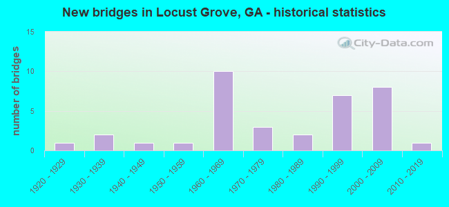
- New bridges - historical statistics
- 11920-1929
- 21930-1939
- 11940-1949
- 11950-1959
- 101960-1969
- 31970-1979
- 21980-1989
- 71990-1999
- 82000-2009
- 12010-2019

- Reconstructed bridges - Historical Statistics
- 11970-1979
- 41980-1989
- 01990-1999
- 12000-2009


- Bridge Condition - Deck
- 4.3%Very good
- 65.2%Good
- 30.4%Satisfactory

- Bridge Condition - Superstructure
- 30.4%Very good
- 52.2%Good
- 13.0%Satisfactory
- 4.3%Poor

- Bridge Condition - Substructure
- 8.7%Very good
- 73.9%Good
- 13.0%Satisfactory
- 4.3%Fair

- Bridge Condition - Channel
- 13.8%Excellent
- 17.2%Very good
- 34.5%Good
- 31.0%Satisfactory
- 3.4%Fair

- Bridge Condition - Culverts
- 15.4%Very good
- 69.2%Good
- 7.7%Satisfactory
- 7.7%Fair
Find on map >> Show street view
Structure Number: 350002, Location: 6 MI W OF JACKSON (Lat: 33.264258, Lng: -84.071289), Route carried "on" structure: State highway 16, Year Built: 1923, Year Reconstructed: 1994, Status: Open, Structure Length: 8.47m (27.79ft), Average Daily Traffic: 6,950 (year 2008), Truck Traffic: 1%, Average Future Daily Traffic: 10,425 (year 2030), Design Load: H 15, Features Intersected: TOWALIGA RIVER
Minimum Vertical Clearance: 30+ m (98+ ft), Kilometerpoint: 3.219, Lanes on structure: 2, Base Highway Network: Yes, Owner: State Highway Agency, Approaching Roadway Width: 8.5m (27.9ft), Material/Design: Concrete, Design/Construction: Tee Beam, Number Of Spans In Main Unit: 9, Length of Maximum Span: 11.6m (38.1ft), Curb-To-Curb Width: 13.4m (44.0ft), Out-to-Out Width: 14.4m (47.2ft)
Condition: Deck: Satisfactory, Superstructure: Good, Substructure: Good, Channel: Good, Operating Rating: 40.8 metric tons, Method Used To Determine Operating Rating: Load Factor (LF), Inventory Rating: 24.4 metric tons, Method Used To Determine Inventory Rating: Load Factor (LF), Structural Evaluation: Equal to present minimum criteria, Deck Geometry: Equal to present minimum criteria, Waterway Adequacy: Equal to present minimum criteria, Approach Roadway Alignment: Somewhat better than minimum adequacy, Designated Inspection Frequency: Every 24 months, Inspection Date: August 2021, Bridge Improvement Cost: $1,086,000, Roadway Improvement Cost: $109,000, Total Project Cost: $1,629,000, Deck Structure Type: Concrete Cast-file-Place
Find on map >> Show street view
Structure Number: 355025, Location: 6 MI SW OF JACKSON (Lat: 33.252389, Lng: -84.056819), Route carried "on" structure: County highway 187, Year Built: 1970, Status: Open, Structure Length: 0.91m (2.99ft), Average Daily Traffic: 600 (year 2011), Truck Traffic: 1%, Average Future Daily Traffic: 900 (year 2031), Design Load: H 15, Features Intersected: LEE CREEK, Facility Carried by Structure: JOE LANE ROAD
Minimum Vertical Clearance: 30+ m (98+ ft), Kilometerpoint: 0.000, Lanes on structure: 2, Base Highway Network: Yes, Owner: County Highway Agency, Approaching Roadway Width: 6.1m (20.0ft), Skew: 4 degrees, Material/Design: Concrete, Design/Construction: Culvert, Number Of Spans In Main Unit: 2, Length of Maximum Span: 4.3m (14.1ft)
Condition: Channel: Good, Culverts: Satisfactory, Operating Rating: 41.7 metric tons, Method Used To Determine Operating Rating: Field evaluation and documented engineering judgment, Inventory Rating: 24.4 metric tons, Method Used To Determine Inventory Rating: Field evaluation and documented engineering judgment, Structural Evaluation: Equal to present minimum criteria, Waterway Adequacy: Better than present minimum criteria, Approach Roadway Alignment: Equal to present minimum criteria, Designated Inspection Frequency: Every 24 months, Inspection Date: August 2021, Bridge Improvement Cost: $117,000, Roadway Improvement Cost: $12,000, Total Project Cost: $176,000
Find on map >> Show street view
Structure Number: 355026, Location: 3 MI SW OF JENKINSBURG (Lat: 33.285778, Lng: -84.064158), Route carried "on" structure: County highway 188, Year Built: 1960, Status: Open, Structure Length: 0.88m (2.89ft), Average Daily Traffic: 490 (year 2012), Truck Traffic: 1%, Average Future Daily Traffic: 735 (year 2032), Design Load: H 15, Features Intersected: TOWALIGA RIVER TRIB, Facility Carried by Structure: DEAN PATRICK ROAD
Minimum Vertical Clearance: 30+ m (98+ ft), Kilometerpoint: 1.609, Lanes on structure: 2, Base Highway Network: Yes, Owner: County Highway Agency, Approaching Roadway Width: 6.1m (20.0ft), Material/Design: Concrete, Design/Construction: Culvert, Number Of Spans In Main Unit: 3, Length of Maximum Span: 2.7m (8.9ft)
Condition: Channel: Good, Culverts: Good, Operating Rating: 41.7 metric tons, Method Used To Determine Operating Rating: Field evaluation and documented engineering judgment, Inventory Rating: 24.4 metric tons, Method Used To Determine Inventory Rating: Field evaluation and documented engineering judgment, Structural Evaluation: Equal to present minimum criteria, Waterway Adequacy: Better than present minimum criteria, Approach Roadway Alignment: Equal to present minimum criteria, Designated Inspection Frequency: Every 24 months, Underwater Inspection Frequency: Every 60 months, Inspection Date: August 2021, Underwater Inspection Date: May 2020, Bridge Improvement Cost: $113,000, Roadway Improvement Cost: $11,000, Total Project Cost: $170,000
Find on map >> Show street view
Structure Number: 355032, Location: 4 MI SW OF JENKINSBURG (Lat: 33.291819, Lng: -84.087100), Route carried "on" structure: County highway 230, Year Built: 1992, Status: Open, Structure Length: 4.27m (14.01ft), Average Daily Traffic: 1,830 (year 2008), Truck Traffic: 1%, Average Future Daily Traffic: 2,745 (year 2030), Design Load: HS 20+Mod, Features Intersected: INDIAN CREEK, Facility Carried by Structure: INDIAN CREEK ROAD
Minimum Vertical Clearance: 30+ m (98+ ft), Kilometerpoint: 0.000, Lanes on structure: 2, Base Highway Network: Yes, Owner: County Highway Agency, Approaching Roadway Width: 5.8m (19.0ft), Material/Design: Prestressed concrete, Design/Construction: Stringer/Multi-beam, Number Of Spans In Main Unit: 2, Length of Maximum Span: 21.3m (69.9ft), Curb-To-Curb Width: 7.3m (24.0ft), Out-to-Out Width: 8.3m (27.2ft)
Condition: Deck: Good, Superstructure: Very good, Substructure: Good, Channel: Very good, Operating Rating: 66.2 metric tons, Method Used To Determine Operating Rating: Load Factor (LF), Inventory Rating: 39.9 metric tons, Method Used To Determine Inventory Rating: Load Factor (LF), Structural Evaluation: Better than present minimum criteria, Deck Geometry: Meets minimum limits, Waterway Adequacy: Equal to present desirable criteria, Approach Roadway Alignment: Equal to present desirable criteria, Designated Inspection Frequency: Every 24 months, Inspection Date: August 2021, Bridge Improvement Cost: $547,000, Roadway Improvement Cost: $55,000, Total Project Cost: $821,000, Deck Structure Type: Concrete Cast-file-Place
Find on map >> Show street view
Structure Number: 355042, Location: 3 MI SW OF JENKINSBURG (Lat: 33.301558, Lng: -84.080569), Route carried "on" structure: County highway 227, Year Built: 1995, Status: Open, Structure Length: 0.88m (2.89ft), Average Daily Traffic: 100 (year 2008), Truck Traffic: 2%, Average Future Daily Traffic: 250 (year 2030), Features Intersected: INDIAN CREEK TRIB, Facility Carried by Structure: LOCUST ROAD
Minimum Vertical Clearance: 30+ m (98+ ft), Kilometerpoint: 1.609, Lanes on structure: 1, Owner: County Highway Agency, Approaching Roadway Width: 6.1m (20.0ft), Skew: 1 degrees, Material/Design: Steel, Design/Construction: Culvert, Number Of Spans In Main Unit: 3, Length of Maximum Span: 2.1m (6.9ft)
Condition: Channel: Good, Culverts: Fair, Operating Rating: 41.7 metric tons, Method Used To Determine Operating Rating: Field evaluation and documented engineering judgment, Inventory Rating: 24.4 metric tons, Method Used To Determine Inventory Rating: Field evaluation and documented engineering judgment, Structural Evaluation: Somewhat better than minimum adequacy, Waterway Adequacy: Better than present minimum criteria, Approach Roadway Alignment: Better than present minimum criteria, Designated Inspection Frequency: Every 24 months, Inspection Date: August 2021, Bridge Improvement Cost: $82,000, Roadway Improvement Cost: $8,000, Total Project Cost: $124,000
Find on map >> Show street view
Structure Number: 355048, Location: 8 MI W OF JACKSON (Lat: 33.261489, Lng: -84.095339), Route carried "on" structure: State highway 16, Year Built: 2006, Status: Open, Structure Length: 9.27m (30.41ft), Average Daily Traffic: 6,850 (year 2008), Truck Traffic: 15%, Average Future Daily Traffic: 10,275 (year 2029), Design Load: HS 20+Mod, Features Intersected: I-75
Minimum Vertical Clearance: 30+ m (98+ ft), Kilometerpoint: 1.609, Lanes on structure: 5, Lanes under structure: 6, Base Highway Network: Yes, Owner: State Highway Agency, Approaching Roadway Width: 19.5m (64.0ft), Skew: 21 degrees, Material/Design: Prestressed concrete, Design/Construction: Stringer/Multi-beam, Number Of Spans In Main Unit: 4, Length of Maximum Span: 31.4m (103.0ft), Curb or Sidewalk Widths: Left: 1.8m (5.9ft), Right: 1.8m (5.9ft), Curb-To-Curb Width: 23.4m (76.8ft), Out-to-Out Width: 27.8m (91.2ft)
Condition: Deck: Good, Superstructure: Good, Substructure: Good, Operating Rating: 51.7 metric tons, Method Used To Determine Operating Rating: Load Factor (LF), Inventory Rating: 30.8 metric tons, Method Used To Determine Inventory Rating: Load Factor (LF), Structural Evaluation: Better than present minimum criteria, Deck Geometry: Better than present minimum criteria, Underclear: Somewhat better than minimum adequacy, Approach Roadway Alignment: Equal to present desirable criteria, Designated Inspection Frequency: Every 24 months, Inspection Date: August 2021, Bridge Improvement Cost: $2,160,000, Roadway Improvement Cost: $216,000, Total Project Cost: $3,239,000, Deck Structure Type: Concrete Cast-file-Place
Find on map >> Show street view
Structure Number: 1510009, Location: 5 MI S OF MCDONOUGH (Lat: 33.382208, Lng: -84.127828), Route carried "on" structure: US 23, Year Built: 1938, Year Reconstructed: 1979, Status: Open, Structure Length: 10.36m (33.99ft), Average Daily Traffic: 11,940 (year 2012), Truck Traffic: 1%, Average Future Daily Traffic: 17,910 (year 2032), Design Load: H 15, Features Intersected: NS RAILROAD
Minimum Vertical Clearance: 30+ m (98+ ft), Kilometerpoint: 11.265, Lanes on structure: 2, Base Highway Network: Yes, Owner: State Highway Agency, Approaching Roadway Width: 7.3m (24.0ft), Material/Design: Steel, Design/Construction: Stringer/Multi-beam, Number Of Spans In Main Unit: 8, Length of Maximum Span: 15.8m (51.8ft), Curb-To-Curb Width: 13.4m (44.0ft), Out-to-Out Width: 14.4m (47.2ft)
Condition: Deck: Satisfactory, Superstructure: Satisfactory, Substructure: Satisfactory, Operating Rating: 36.2 metric tons, Method Used To Determine Operating Rating: Load Factor (LF), Inventory Rating: 21.7 metric tons, Method Used To Determine Inventory Rating: Load Factor (LF), Structural Evaluation: Somewhat better than minimum adequacy, Deck Geometry: Equal to present minimum criteria, Underclear: Meets minimum limits, Approach Roadway Alignment: Meets minimum limits, Designated Inspection Frequency: Every 24 months, Critical Feature Inspection Frequency: Every 24 months, Inspection Date: November 2020, Critical Feature Inspection Date: June 2021, Bridge Improvement Cost: $1,328,000, Roadway Improvement Cost: $133,000, Total Project Cost: $1,993,000, Deck Structure Type: Concrete Cast-file-Place, Wearing Surface/Protective System: Wearing Surface: Bituminous
Find on map >> Show street view
Structure Number: 1510025, Location: 2.5 MI NW OF LOCUST GROVE (Lat: 33.377756, Lng: -84.138656), Route carried "on" structure: County highway 312, Year Built: 1966, Status: Open, Structure Length: 7.99m (26.21ft), Average Daily Traffic: 1,110 (year 2011), Truck Traffic: 1%, Average Future Daily Traffic: 1,665 (year 2031), Design Load: H 15, Features Intersected: I-75, Facility Carried by Structure: BETHLEHEM ROAD
Minimum Vertical Clearance: 30+ m (98+ ft), Kilometerpoint: 1.609, Lanes on structure: 2, Lanes under structure: 6, Base Highway Network: Yes, Owner: State Highway Agency, Approaching Roadway Width: 6.4m (21.0ft), Material/Design: Steel, Design/Construction: Stringer/Multi-beam, Number Of Spans In Main Unit: 4, Length of Maximum Span: 21.6m (70.9ft), Curb or Sidewalk Widths: Left: 0.6m (2.0ft), Right: 0.6m (2.0ft), Curb-To-Curb Width: 7.3m (24.0ft), Out-to-Out Width: 9.4m (30.8ft)
Condition: Deck: Satisfactory, Superstructure: Good, Substructure: Good, Operating Rating: 33.5 metric tons, Method Used To Determine Operating Rating: Allowable Stress (AS), Inventory Rating: 17.2 metric tons, Method Used To Determine Inventory Rating: Allowable Stress (AS), Structural Evaluation: Meets minimum limits, Deck Geometry: Meets minimum limits, Underclear: Meets minimum limits, Approach Roadway Alignment: Somewhat better than minimum adequacy, Designated Inspection Frequency: Every 24 months, Inspection Date: December 2020, Bridge Improvement Cost: $1,024,000, Roadway Improvement Cost: $102,000, Total Project Cost: $1,536,000, Deck Structure Type: Concrete Cast-file-Place
Find on map >> Show street view
Structure Number: 1510026, Location: 2 MI S OF LOCUST GROVE (Lat: 33.331083, Lng: -84.122122), Route carried "on" structure: County highway 326, Year Built: 1966, Status: Open, Structure Length: 8.11m (26.61ft), Average Daily Traffic: 300 (year 2011), Truck Traffic: 1%, Average Future Daily Traffic: 450 (year 2031), Design Load: H 15, Features Intersected: I-75, Facility Carried by Structure: INDIAN CREEK RD
Minimum Vertical Clearance: 30+ m (98+ ft), Kilometerpoint: 3.219, Lanes on structure: 2, Lanes under structure: 6, Base Highway Network: Yes, Owner: State Highway Agency, Approaching Roadway Width: 6.1m (20.0ft), Skew: 1 degrees, Material/Design: Steel, Design/Construction: Stringer/Multi-beam, Number Of Spans In Main Unit: 4, Length of Maximum Span: 21.6m (70.9ft), Curb or Sidewalk Widths: Left: 0.6m (2.0ft), Right: 0.6m (2.0ft), Curb-To-Curb Width: 7.3m (24.0ft), Out-to-Out Width: 9.3m (30.5ft)
Condition: Deck: Good, Superstructure: Good, Substructure: Good, Operating Rating: 33.5 metric tons, Method Used To Determine Operating Rating: Allowable Stress (AS), Inventory Rating: 17.2 metric tons, Method Used To Determine Inventory Rating: Allowable Stress (AS), Structural Evaluation: Somewhat better than minimum adequacy, Deck Geometry: Somewhat better than minimum adequacy, Underclear: Meets minimum limits, Approach Roadway Alignment: Meets minimum limits, Designated Inspection Frequency: Every 24 months, Inspection Date: December 2020, Bridge Improvement Cost: $1,039,000, Roadway Improvement Cost: $104,000, Total Project Cost: $1,559,000, Deck Structure Type: Concrete Cast-file-Place
Find on map >> Show street view
Structure Number: 1510029, Location: 2 MI S OF LOCUST GROVE (Lat: 33.328419, Lng: -84.121708), Route carried "on" structure: Interstate 75, Year Built: 1966, Year Reconstructed: 1985, Status: Open, Structure Length: 4.75m (15.58ft), Average Daily Traffic: 72,700 (year 2011), Truck Traffic: 1%, Average Future Daily Traffic: 109,050 (year 2031), Design Load: HS 20+Mod, Features Intersected: INDIAN CREEK
Minimum Vertical Clearance: 30+ m (98+ ft), Kilometerpoint: 337.962, Lanes on structure: 6, Base Highway Network: Yes, Owner: State Highway Agency, Approaching Roadway Width: 35.4m (116.1ft), Skew: 30 degrees, Material/Design: Prestressed concrete, Design/Construction: Stringer/Multi-beam, Number Of Spans In Main Unit: 3, Length of Maximum Span: 15.8m (51.8ft), Curb-To-Curb Width: 39.4m (129.3ft), Out-to-Out Width: 40.9m (134.2ft)
Condition: Deck: Good, Superstructure: Good, Substructure: Satisfactory, Channel: Satisfactory, Operating Rating: 53.5 metric tons, Method Used To Determine Operating Rating: Load Factor (LF), Inventory Rating: 31.7 metric tons, Method Used To Determine Inventory Rating: Load Factor (LF), Structural Evaluation: Equal to present minimum criteria, Deck Geometry: Superior to present desirable criteria, Waterway Adequacy: Equal to present minimum criteria, Approach Roadway Alignment: Equal to present desirable criteria, Designated Inspection Frequency: Every 24 months, Inspection Date: December 2020, Bridge Improvement Cost: $1,274,000, Roadway Improvement Cost: $127,000, Total Project Cost: $1,912,000, Deck Structure Type: Concrete Cast-file-Place
Find on map >> Show street view
Structure Number: 1510031, Location: IN LOCUST GROVE (Lat: 33.352900, Lng: -84.124947), Route carried "on" structure: Interstate 75, Year Built: 1966, Year Reconstructed: 1985, Status: Open, Structure Length: 5.52m (18.11ft), Average Daily Traffic: 83,820 (year 2011), Truck Traffic: 1%, Average Future Daily Traffic: 125,730 (year 2031), Design Load: HS 20+Mod, Features Intersected: BILL GARDNER PKWY
Minimum Vertical Clearance: 30+ m (98+ ft), Kilometerpoint: 341.181, Lanes on structure: 6, Lanes under structure: 4, Base Highway Network: Yes, Owner: State Highway Agency, Approaching Roadway Width: 35.4m (116.1ft), Skew: 30 degrees, Material/Design: Steel, Design/Construction: Stringer/Multi-beam, Number Of Spans In Main Unit: 3, Length of Maximum Span: 21.9m (71.9ft), Curb-To-Curb Width: 38.7m (127.0ft), Out-to-Out Width: 40.6m (133.2ft)
Condition: Deck: Good, Superstructure: Good, Substructure: Good, Operating Rating: 34.4 metric tons, Method Used To Determine Operating Rating: Load Factor (LF), Inventory Rating: 20.8 metric tons, Method Used To Determine Inventory Rating: Load Factor (LF), Structural Evaluation: Somewhat better than minimum adequacy, Deck Geometry: Superior to present desirable criteria, Underclear: Somewhat better than minimum adequacy, Approach Roadway Alignment: Equal to present desirable criteria, Designated Inspection Frequency: Every 24 months, Inspection Date: December 2020, Bridge Improvement Cost: $1,479,000, Roadway Improvement Cost: $148,000, Total Project Cost: $2,218,000, Deck Structure Type: Concrete Cast-file-Place, Wearing Surface/Protective System: Wearing Surface: Epoxy Overlay, Membrane: Epoxy
Find on map >> Show street view
Structure Number: 1510048, Location: 3 MI S OF LOCUST GROVE (Lat: 33.314039, Lng: -84.117558), Route carried "on" structure: County highway 755, Year Built: 1967, Status: Open, Structure Length: 9.72m (31.89ft), Average Daily Traffic: 2,160 (year 2011), Truck Traffic: 1%, Average Future Daily Traffic: 3,240 (year 2031), Design Load: H 15, Features Intersected: I-75, Facility Carried by Structure: LOCUST GROVE RD
Minimum Vertical Clearance: 30+ m (98+ ft), Kilometerpoint: 1.609, Lanes on structure: 2, Lanes under structure: 6, Base Highway Network: Yes, Owner: State Highway Agency, Approaching Roadway Width: 6.4m (21.0ft), Skew: 3 degrees, Material/Design: Steel, Design/Construction: Stringer/Multi-beam, Number Of Spans In Main Unit: 4, Length of Maximum Span: 26.2m (86.0ft), Curb or Sidewalk Widths: Left: 0.6m (2.0ft), Right: 0.6m (2.0ft), Curb-To-Curb Width: 7.9m (25.9ft), Out-to-Out Width: 9.9m (32.5ft)
Condition: Deck: Good, Superstructure: Good, Substructure: Good, Operating Rating: 35.3 metric tons, Method Used To Determine Operating Rating: Allowable Stress (AS), Inventory Rating: 19.0 metric tons, Method Used To Determine Inventory Rating: Allowable Stress (AS), Structural Evaluation: Somewhat better than minimum adequacy, Deck Geometry: High priority of corrective action, Underclear: Meets minimum limits, Approach Roadway Alignment: Meets minimum limits, Length Of Structure Improvement: 49.96m (163.91ft), Designated Inspection Frequency: Every 24 months, Inspection Date: December 2020, Bridge Improvement Cost: $1,246,000, Roadway Improvement Cost: $125,000, Total Project Cost: $1,870,000, Deck Structure Type: Concrete Cast-file-Place
Find on map >> Show street view
Structure Number: 1510049, Location: 3 MI S OF LOCUST GROVE (Lat: 33.316947, Lng: -84.115669), Route carried "on" structure: County highway 755, Year Built: 1981, Status: Open, Structure Length: 5.79m (19.00ft), Average Daily Traffic: 2,160 (year 2011), Truck Traffic: 1%, Average Future Daily Traffic: 3,240 (year 2031), Design Load: HS 15, Features Intersected: INDIAN CREEK, Facility Carried by Structure: LOCUST GROVE RD
Minimum Vertical Clearance: 30+ m (98+ ft), Kilometerpoint: 1.609, Lanes on structure: 2, Base Highway Network: Yes, Owner: County Highway Agency, Approaching Roadway Width: 6.1m (20.0ft), Material/Design: Concrete, Design/Construction: Tee Beam, Number Of Spans In Main Unit: 5, Length of Maximum Span: 12.2m (40.0ft), Curb-To-Curb Width: 9.3m (30.5ft), Out-to-Out Width: 10.2m (33.5ft)
Condition: Deck: Good, Superstructure: Good, Substructure: Good, Channel: Satisfactory, Operating Rating: 32.6 metric tons, Method Used To Determine Operating Rating: Load Factor (LF), Inventory Rating: 19.9 metric tons, Method Used To Determine Inventory Rating: Load Factor (LF), Structural Evaluation: Somewhat better than minimum adequacy, Deck Geometry: Meets minimum limits, Waterway Adequacy: Equal to present desirable criteria, Approach Roadway Alignment: Equal to present desirable criteria, Designated Inspection Frequency: Every 24 months, Inspection Date: December 2020, Bridge Improvement Cost: $742,000, Roadway Improvement Cost: $74,000, Total Project Cost: $1,114,000, Deck Structure Type: Concrete Cast-file-Place
Find on map >> Show street view
Structure Number: 1510054, Location: 1 MI W OF LOCUST GROVE (Lat: 33.350708, Lng: -84.140869), Route carried "on" structure: County highway 1577, Year Built: 1986, Status: Open, Structure Length: 1.40m (4.59ft), Average Daily Traffic: 2,700 (year 2012), Truck Traffic: 1%, Average Future Daily Traffic: 4,050 (year 2032), Design Load: HS 20+Mod, Features Intersected: INDIAN CREEK, Facility Carried by Structure: HAMPTON ROAD
Minimum Vertical Clearance: 30+ m (98+ ft), Kilometerpoint: 14.484, Lanes on structure: 2, Base Highway Network: Yes, Owner: County Highway Agency, Approaching Roadway Width: 6.1m (20.0ft), Skew: 2 degrees, Material/Design: Concrete, Design/Construction: Culvert, Number Of Spans In Main Unit: 4, Length of Maximum Span: 3.4m (11.2ft)
Condition: Channel: Good, Culverts: Good, Operating Rating: 55.3 metric tons, Method Used To Determine Operating Rating: Field evaluation and documented engineering judgment, Inventory Rating: 32.6 metric tons, Method Used To Determine Inventory Rating: Field evaluation and documented engineering judgment, Structural Evaluation: Better than present minimum criteria, Waterway Adequacy: Equal to present desirable criteria, Approach Roadway Alignment: Better than present minimum criteria, Designated Inspection Frequency: Every 24 months, Underwater Inspection Frequency: Every 60 months, Inspection Date: November 2020, Underwater Inspection Date: December 2019, Bridge Improvement Cost: $180,000, Roadway Improvement Cost: $18,000, Total Project Cost: $270,000
Find on map >> Show street view
Structure Number: 1510055, Location: 5.3 MI E OF LOCUST GROVE (Lat: 33.359378, Lng: -84.043039), Route carried "on" structure: County highway 1577, Year Built: 1992, Status: Open, Structure Length: 0.64m (2.10ft), Average Daily Traffic: 3,530 (year 2011), Truck Traffic: 1%, Average Future Daily Traffic: 5,295 (year 2031), Design Load: HS 20+Mod, Features Intersected: BROWN BRANCH, Facility Carried by Structure: PEEKSVILLE ROAD
Minimum Vertical Clearance: 30+ m (98+ ft), Kilometerpoint: 24.140, Lanes on structure: 2, Base Highway Network: Yes, Owner: County Highway Agency, Approaching Roadway Width: 6.4m (21.0ft), Material/Design: Concrete, Design/Construction: Culvert, Number Of Spans In Main Unit: 2, Length of Maximum Span: 3.0m (9.8ft)
Condition: Channel: Satisfactory, Culverts: Good, Operating Rating: 55.3 metric tons, Method Used To Determine Operating Rating: Field evaluation and documented engineering judgment, Inventory Rating: 32.6 metric tons, Method Used To Determine Inventory Rating: Field evaluation and documented engineering judgment, Structural Evaluation: Better than present minimum criteria, Waterway Adequacy: Equal to present desirable criteria, Approach Roadway Alignment: Equal to present desirable criteria, Designated Inspection Frequency: Every 24 months, Inspection Date: November 2020, Bridge Improvement Cost: $82,000, Roadway Improvement Cost: $8,000, Total Project Cost: $123,000
Find on map >> Show street view
Structure Number: 1515031, Location: 2 MI W OF LOCUST GROVE (Lat: 33.362678, Lng: -84.150428), Route carried "on" structure: County highway 301, Year Built: 1992, Year Reconstructed: 2006, Status: Open, Structure Length: 0.88m (2.89ft), Average Daily Traffic: 1,090 (year 2011), Truck Traffic: 1%, Average Future Daily Traffic: 1,635 (year 2031), Design Load: HS 20+Mod, Features Intersected: INDIAN CREEK, Facility Carried by Structure: LESTER MILL ROAD
Minimum Vertical Clearance: 30+ m (98+ ft), Kilometerpoint: 4.828, Lanes on structure: 2, Base Highway Network: Yes, Owner: County Highway Agency, Approaching Roadway Width: 7.3m (24.0ft), Material/Design: Concrete, Design/Construction: Culvert, Number Of Spans In Main Unit: 3, Length of Maximum Span: 2.7m (8.9ft)
Condition: Channel: Satisfactory, Culverts: Good, Operating Rating: 55.3 metric tons, Method Used To Determine Operating Rating: Field evaluation and documented engineering judgment, Inventory Rating: 32.6 metric tons, Method Used To Determine Inventory Rating: Field evaluation and documented engineering judgment, Structural Evaluation: Better than present minimum criteria, Waterway Adequacy: Equal to present desirable criteria, Approach Roadway Alignment: Equal to present desirable criteria, Designated Inspection Frequency: Every 24 months, Inspection Date: November 2020, Bridge Improvement Cost: $113,000, Roadway Improvement Cost: $11,000, Total Project Cost: $170,000
Find on map >> Show street view
Structure Number: 1515035, Location: 3.5 MI E OF LOCUST GROVE (Lat: 33.357908, Lng: -84.058439), Route carried "on" structure: County highway 352, Year Built: 1960, Status: Open, Structure Length: 0.98m (3.22ft), Average Daily Traffic: 2,640 (year 2011), Truck Traffic: 1%, Average Future Daily Traffic: 3,960 (year 2031), Design Load: H 15, Features Intersected: BROWN BRANCH, Facility Carried by Structure: SOUTH OLA ROAD
Minimum Vertical Clearance: 30+ m (98+ ft), Kilometerpoint: 3.219, Lanes on structure: 2, Base Highway Network: Yes, Owner: County Highway Agency, Approaching Roadway Width: 6.1m (20.0ft), Material/Design: Concrete, Design/Construction: Culvert, Number Of Spans In Main Unit: 3, Length of Maximum Span: 3.0m (9.8ft)
Condition: Channel: Satisfactory, Culverts: Good, Operating Rating: 41.7 metric tons, Method Used To Determine Operating Rating: Field evaluation and documented engineering judgment, Inventory Rating: 24.4 metric tons, Method Used To Determine Inventory Rating: Field evaluation and documented engineering judgment, Structural Evaluation: Equal to present minimum criteria, Waterway Adequacy: Better than present minimum criteria, Approach Roadway Alignment: Equal to present desirable criteria, Designated Inspection Frequency: Every 24 months, Inspection Date: November 2020, Bridge Improvement Cost: $125,000, Roadway Improvement Cost: $13,000, Total Project Cost: $188,000
Find on map >> Show street view
Structure Number: 1515039, Location: 4 MI NE OF LOCUST GROVE (Lat: 33.391378, Lng: -84.068869), Route carried "on" structure: County highway 373, Year Built: 1971, Status: Open, Structure Length: 0.85m (2.79ft), Average Daily Traffic: 2,240 (year 2011), Truck Traffic: 1%, Average Future Daily Traffic: 3,360 (year 2031), Design Load: H 15, Features Intersected: TUSSAHAW CREEK TRIB, Facility Carried by Structure: COAN DRIVE
Minimum Vertical Clearance: 30+ m (98+ ft), Kilometerpoint: 0.000, Lanes on structure: 2, Base Highway Network: Yes, Owner: County Highway Agency, Approaching Roadway Width: 5.8m (19.0ft), Material/Design: Concrete, Design/Construction: Culvert, Number Of Spans In Main Unit: 3, Length of Maximum Span: 2.4m (7.9ft)
Condition: Channel: Satisfactory, Culverts: Good, Operating Rating: 41.7 metric tons, Method Used To Determine Operating Rating: Field evaluation and documented engineering judgment, Inventory Rating: 24.4 metric tons, Method Used To Determine Inventory Rating: Field evaluation and documented engineering judgment, Structural Evaluation: Equal to present minimum criteria, Waterway Adequacy: Equal to present desirable criteria, Approach Roadway Alignment: Better than present minimum criteria, Designated Inspection Frequency: Every 24 months, Inspection Date: October 2020, Bridge Improvement Cost: $109,000, Roadway Improvement Cost: $11,000, Total Project Cost: $164,000
Find on map >> Show street view
Structure Number: 1515056, Location: 5 MI NE OF LOCUST GROVE (Lat: 33.398869, Lng: -84.054019), Route carried "on" structure: County highway 396, Year Built: 1992, Status: Posted for load, Structure Length: 3.35m (10.99ft), Average Daily Traffic: 1,450 (year 2011), Truck Traffic: 1%, Average Future Daily Traffic: 2,175 (year 2031), Design Load: H 20, Features Intersected: TUSSAHAW CREEK, Facility Carried by Structure: SOUTH OLA ROAD
Minimum Vertical Clearance: 30+ m (98+ ft), Kilometerpoint: 1.609, Lanes on structure: 2, Base Highway Network: Yes, Owner: County Highway Agency, Approaching Roadway Width: 6.4m (21.0ft), Skew: 3 degrees, Material/Design: Concrete, Design/Construction: Slab, Number Of Spans In Main Unit: 4, Length of Maximum Span: 9.1m (29.9ft), Curb-To-Curb Width: 8.5m (27.9ft), Out-to-Out Width: 9.5m (31.2ft)
Condition: Deck: Good, Superstructure: Good, Substructure: Good, Channel: Good, Operating Rating: 56.2 metric tons, Method Used To Determine Operating Rating: Load Factor (LF), Inventory Rating: 33.5 metric tons, Method Used To Determine Inventory Rating: Load Factor (LF), Structural Evaluation: Better than present minimum criteria, Deck Geometry: Somewhat better than minimum adequacy, Waterway Adequacy: Equal to present desirable criteria, Approach Roadway Alignment: Meets minimum limits, Designated Inspection Frequency: Every 24 months, Inspection Date: November 2020, Bridge Improvement Cost: $430,000, Roadway Improvement Cost: $43,000, Total Project Cost: $645,000, Deck Structure Type: Concrete Cast-file-Place
Find on map >> Show street view
Structure Number: 1515058, Location: 4 MI NE OF LOCUST GROVE (Lat: 33.393389, Lng: -84.067447), Route carried "on" structure: County highway 2001, Year Built: 1994, Status: Open, Structure Length: 3.66m (12.01ft), Average Daily Traffic: 2,700 (year 2011), Truck Traffic: 1%, Average Future Daily Traffic: 4,050 (year 2031), Design Load: HS 20+Mod, Features Intersected: TUSSAHAW CREEK, Facility Carried by Structure: OLD JACKSON RD
Minimum Vertical Clearance: 30+ m (98+ ft), Kilometerpoint: 6.437, Lanes on structure: 2, Base Highway Network: Yes, Owner: County Highway Agency, Approaching Roadway Width: 6.1m (20.0ft), Material/Design: Concrete, Design/Construction: Tee Beam, Number Of Spans In Main Unit: 4, Length of Maximum Span: 9.1m (29.9ft), Curb-To-Curb Width: 10.4m (34.1ft), Out-to-Out Width: 11.4m (37.4ft)
Condition: Deck: Good, Superstructure: Very good, Substructure: Good, Channel: Very good, Operating Rating: 63.5 metric tons, Method Used To Determine Operating Rating: Load Factor (LF), Inventory Rating: 38.1 metric tons, Method Used To Determine Inventory Rating: Load Factor (LF), Structural Evaluation: Better than present minimum criteria, Deck Geometry: Somewhat better than minimum adequacy, Waterway Adequacy: Equal to present minimum criteria, Approach Roadway Alignment: Better than present minimum criteria, Designated Inspection Frequency: Every 24 months, Inspection Date: November 2020, Bridge Improvement Cost: $469,000, Roadway Improvement Cost: $47,000, Total Project Cost: $703,000, Deck Structure Type: Concrete Cast-file-Place
Find on map >> Show street view
Structure Number: 1515064, Location: 6 MI E OF LOCUST GROVE (Lat: 33.384919, Lng: -84.034828), Route carried "on" structure: County highway 354, Year Built: 2000, Status: Open, Structure Length: 6.40m (21.00ft), Average Daily Traffic: 1,430 (year 2011), Truck Traffic: 1%, Average Future Daily Traffic: 2,145 (year 2031), Design Load: HS 20+Mod, Features Intersected: TUSSAHAW CREEK, Facility Carried by Structure: LEGUIN MILL ROAD
Minimum Vertical Clearance: 30+ m (98+ ft), Kilometerpoint: 6.437, Lanes on structure: 2, Base Highway Network: Yes, Owner: County Highway Agency, Approaching Roadway Width: 6.1m (20.0ft), Skew: 1 degrees, Material/Design: Prestressed concrete, Design/Construction: Stringer/Multi-beam, Number Of Spans In Main Unit: 3, Length of Maximum Span: 25.9m (85.0ft), Curb-To-Curb Width: 9.6m (31.5ft), Out-to-Out Width: 10.6m (34.8ft)
Condition: Deck: Good, Superstructure: Very good, Substructure: Good, Channel: Very good, Operating Rating: 41.7 metric tons, Method Used To Determine Operating Rating: Load Factor (LF), Inventory Rating: 24.4 metric tons, Method Used To Determine Inventory Rating: Load Factor (LF), Structural Evaluation: Equal to present minimum criteria, Deck Geometry: Somewhat better than minimum adequacy, Waterway Adequacy: Superior to present desirable criteria, Approach Roadway Alignment: Better than present minimum criteria, Designated Inspection Frequency: Every 24 months, Inspection Date: November 2020, Bridge Improvement Cost: $821,000, Roadway Improvement Cost: $82,000, Total Project Cost: $1,231,000, Deck Structure Type: Concrete Cast-file-Place
Find on map >> Show street view
Structure Number: 1515068, Location: 3 MI N OF LUELLA (Lat: 33.387978, Lng: -84.159239), Route carried "on" structure: County highway 1905, Year Built: 1999, Status: Open, Structure Length: 3.81m (12.50ft), Average Daily Traffic: 1,090 (year 2011), Truck Traffic: 1%, Average Future Daily Traffic: 1,635 (year 2031), Design Load: HS 20+Mod, Features Intersected: BETHLEHEM BOTTOMS TRIB, Facility Carried by Structure: GREENWOOD ROAD
Minimum Vertical Clearance: 30+ m (98+ ft), Kilometerpoint: 1.609, Lanes on structure: 2, Base Highway Network: Yes, Owner: County Highway Agency, Approaching Roadway Width: 8.8m (28.9ft), Material/Design: Prestressed concrete, Design/Construction: Stringer/Multi-beam, Number Of Spans In Main Unit: 3, Length of Maximum Span: 19.8m (65.0ft), Curb or Sidewalk Widths: Left: 1.8m (5.9ft), Right: 1.8m (5.9ft), Curb-To-Curb Width: 8.8m (28.9ft), Out-to-Out Width: 13.4m (44.0ft)
Condition: Deck: Good, Superstructure: Very good, Substructure: Good, Channel: Good, Operating Rating: 52.6 metric tons, Method Used To Determine Operating Rating: Load Factor (LF), Inventory Rating: 32.6 metric tons, Method Used To Determine Inventory Rating: Load Factor (LF), Structural Evaluation: Better than present minimum criteria, Deck Geometry: Somewhat better than minimum adequacy, Waterway Adequacy: Superior to present desirable criteria, Approach Roadway Alignment: Superior to present desirable criteria, Designated Inspection Frequency: Every 24 months, Inspection Date: November 2020, Bridge Improvement Cost: $488,000, Roadway Improvement Cost: $49,000, Total Project Cost: $733,000, Deck Structure Type: Concrete Cast-file-Place
Find on map >> Show street view
Structure Number: 1515087, Location: 1.1 MI SE OF GREENWOOD (Lat: 33.391158, Lng: -84.158089), Route carried "on" structure: Business County highway 2527, Year Built: 2004, Status: Open, Structure Length: 1.01m (3.31ft), Average Daily Traffic: 2,390 (year 2011), Truck Traffic: 1%, Average Future Daily Traffic: 3,585 (year 2031), Design Load: HS 20+Mod, Features Intersected: BETHLEHEM BOTTOMS, Facility Carried by Structure: BETHLEHEM BOTTOMS
Minimum Vertical Clearance: 30+ m (98+ ft), Kilometerpoint: 0.000, Lanes on structure: 2, Base Highway Network: Yes, Owner: County Highway Agency, Approaching Roadway Width: 8.8m (28.9ft), Skew: 1 degrees, Material/Design: Concrete, Design/Construction: Culvert, Number Of Spans In Main Unit: 3, Length of Maximum Span: 3.0m (9.8ft), Curb or Sidewalk Widths: Left: 0.2m (0.7ft), Right: 0.2m (0.7ft)
Condition: Channel: Excellent, Culverts: Very good, Operating Rating: 55.3 metric tons, Method Used To Determine Operating Rating: Field evaluation and documented engineering judgment, Inventory Rating: 32.6 metric tons, Method Used To Determine Inventory Rating: Field evaluation and documented engineering judgment, Structural Evaluation: Equal to present desirable criteria, Waterway Adequacy: Superior to present desirable criteria, Approach Roadway Alignment: Superior to present desirable criteria, Designated Inspection Frequency: Every 24 months, Inspection Date: November 2020, Bridge Improvement Cost: $129,000, Roadway Improvement Cost: $13,000, Total Project Cost: $193,000
Find on map >> Show street view
Structure Number: 1515092, Location: 3.5 MI NORTH EAST OF LOCU (Lat: 33.387042, Lng: -84.078903), Route carried "on" structure: County highway 2844, Year Built: 2003, Status: Open, Structure Length: 2.44m (8.01ft), Average Daily Traffic: 600 (year 2011), Truck Traffic: 1%, Average Future Daily Traffic: 900 (year 2031), Features Intersected: TUSSAHAW BRANCH, Facility Carried by Structure: KIMBALL FARM DRIVE
Minimum Vertical Clearance: 30+ m (98+ ft), Kilometerpoint: 0.000, Lanes on structure: 2, Base Highway Network: Yes, Owner: County Highway Agency, Approaching Roadway Width: 7.6m (24.9ft), Material/Design: Prestressed concrete, Design/Construction: Stringer/Multi-beam, Number Of Spans In Main Unit: 1, Length of Maximum Span: 24.4m (80.1ft), Curb or Sidewalk Widths: Left: 0.0m, Right: 1.5m (4.9ft), Curb-To-Curb Width: 7.6m (24.9ft), Out-to-Out Width: 10.1m (33.1ft)
Condition: Deck: Very good, Superstructure: Very good, Substructure: Very good, Channel: Excellent, Operating Rating: 47.1 metric tons, Method Used To Determine Operating Rating: Allowable Stress (AS), Inventory Rating: 24.4 metric tons, Method Used To Determine Inventory Rating: Allowable Stress (AS), Structural Evaluation: Equal to present minimum criteria, Deck Geometry: Meets minimum limits, Waterway Adequacy: Equal to present desirable criteria, Approach Roadway Alignment: Superior to present desirable criteria, Designated Inspection Frequency: Every 24 months, Inspection Date: October 2020, Bridge Improvement Cost: $313,000, Roadway Improvement Cost: $31,000, Total Project Cost: $469,000, Deck Structure Type: Concrete Cast-file-Place
Find on map >> Show street view
Structure Number: 1515093, Location: 2 MI NORTH WEST OF LOCUST (Lat: 33.357931, Lng: -84.078411), Route carried "on" structure: County highway 341, Year Built: 2007, Status: Open, Structure Length: 0.82m (2.69ft), Average Daily Traffic: 110 (year 2011), Truck Traffic: 1%, Average Future Daily Traffic: 165 (year 2031), Design Load: HS 20+Mod, Features Intersected: BROWN BRANCH, Facility Carried by Structure: NORTH UNITY GROVE
Minimum Vertical Clearance: 30+ m (98+ ft), Kilometerpoint: 1.609, Lanes on structure: 2, Base Highway Network: Yes, Owner: County Highway Agency, Approaching Roadway Width: 7.3m (24.0ft), Skew: 1 degrees, Material/Design: Concrete, Design/Construction: Culvert, Number Of Spans In Main Unit: 3, Length of Maximum Span: 2.4m (7.9ft)
Condition: Channel: Very good, Culverts: Very good, Operating Rating: 55.3 metric tons, Method Used To Determine Operating Rating: Field evaluation and documented engineering judgment, Inventory Rating: 32.6 metric tons, Method Used To Determine Inventory Rating: Field evaluation and documented engineering judgment, Structural Evaluation: Equal to present desirable criteria, Waterway Adequacy: Equal to present desirable criteria, Approach Roadway Alignment: Superior to present desirable criteria, Designated Inspection Frequency: Every 24 months, Inspection Date: November 2020, Bridge Improvement Cost: $105,000, Roadway Improvement Cost: $11,000, Total Project Cost: $158,000
Find on map >> Show street view
Structure Number: 1515094, Location: 2 MI NORTH OF JENKINSBURG (Lat: 33.347478, Lng: -84.049539), Route carried "on" structure: County highway 339, Year Built: 2000, Status: Open, Structure Length: 0.91m (2.99ft), Average Daily Traffic: 280 (year 2011), Truck Traffic: 1%, Average Future Daily Traffic: 420 (year 2031), Features Intersected: WOLF CREEK TRIB, Facility Carried by Structure: BURG ROAD
Minimum Vertical Clearance: 30+ m (98+ ft), Kilometerpoint: 1.609, Lanes on structure: 2, Base Highway Network: Yes, Owner: County Highway Agency, Approaching Roadway Width: 5.5m (18.0ft), Skew: 2 degrees, Material/Design: Prestressed concrete, Design/Construction: Box Beam or Girders - Multiple, Number Of Spans In Main Unit: 1, Length of Maximum Span: 9.1m (29.9ft), Curb-To-Curb Width: 6.2m (20.3ft), Out-to-Out Width: 7.1m (23.3ft)
Condition: Deck: Good, Superstructure: Very good, Substructure: Good, Channel: Good, Operating Rating: 49.8 metric tons, Method Used To Determine Operating Rating: Load Factor (LF), Inventory Rating: 29.9 metric tons, Method Used To Determine Inventory Rating: Load Factor (LF), Structural Evaluation: Better than present minimum criteria, Deck Geometry: Meets minimum limits, Waterway Adequacy: Better than present minimum criteria, Approach Roadway Alignment: Equal to present minimum criteria, Designated Inspection Frequency: Every 24 months, Inspection Date: November 2020, Bridge Improvement Cost: $117,000, Roadway Improvement Cost: $12,000, Total Project Cost: $176,000, Deck Structure Type: Concrete Precast Panels
Find on map >> Show street view
Structure Number: 1515095, Location: 3 MI EAST OF LOCUST GROVE (Lat: 33.347778, Lng: -84.061889), Route carried "on" structure: County highway 344, Year Built: 2007, Status: Open, Structure Length: 1.34m (4.40ft), Average Daily Traffic: 840 (year 2011), Truck Traffic: 1%, Average Future Daily Traffic: 1,260 (year 2031), Design Load: HS 20+Mod, Features Intersected: WOLF CREEK, Facility Carried by Structure: SOUTH OLA ROAD
Minimum Vertical Clearance: 30+ m (98+ ft), Kilometerpoint: 0.000, Lanes on structure: 2, Base Highway Network: Yes, Owner: County Highway Agency, Approaching Roadway Width: 7.3m (24.0ft), Material/Design: Concrete, Design/Construction: Culvert, Number Of Spans In Main Unit: 4, Length of Maximum Span: 3.0m (9.8ft)
Condition: Channel: Excellent, Culverts: Good, Operating Rating: 55.3 metric tons, Method Used To Determine Operating Rating: Field evaluation and documented engineering judgment, Inventory Rating: 32.6 metric tons, Method Used To Determine Inventory Rating: Field evaluation and documented engineering judgment, Structural Evaluation: Better than present minimum criteria, Waterway Adequacy: Equal to present desirable criteria, Approach Roadway Alignment: Equal to present desirable criteria, Designated Inspection Frequency: Every 24 months, Inspection Date: November 2020, Bridge Improvement Cost: $172,000, Roadway Improvement Cost: $17,000, Total Project Cost: $258,000
Find on map >> Show street view
Structure Number: 1515108, Location: 2.6 MI NW OF LOCUST GROVE (Lat: 33.376439, Lng: -84.149328), Route carried "on" structure: County highway 312, Year Built: 2007, Status: Open, Structure Length: 1.83m (6.00ft), Average Daily Traffic: 1,110 (year 2011), Truck Traffic: 1%, Average Future Daily Traffic: 1,665 (year 2031), Design Load: HS 20+Mod, Features Intersected: BETHLEHEM BOTTOMS, Facility Carried by Structure: BETHLEHEM ROAD
Minimum Vertical Clearance: 30+ m (98+ ft), Kilometerpoint: 1.609, Lanes on structure: 2, Base Highway Network: Yes, Owner: County Highway Agency, Approaching Roadway Width: 7.3m (24.0ft), Material/Design: Prestressed concrete, Design/Construction: Stringer/Multi-beam, Number Of Spans In Main Unit: 1, Length of Maximum Span: 18.3m (60.0ft), Curb or Sidewalk Widths: Left: 1.8m (5.9ft), Right: 1.8m (5.9ft), Curb-To-Curb Width: 8.5m (27.9ft), Out-to-Out Width: 13.0m (42.7ft)
Condition: Deck: Good, Superstructure: Very good, Substructure: Very good, Channel: Excellent, Operating Rating: 52.6 metric tons, Method Used To Determine Operating Rating: Allowable Stress (AS), Inventory Rating: 32.6 metric tons, Method Used To Determine Inventory Rating: Allowable Stress (AS), Structural Evaluation: Equal to present desirable criteria, Deck Geometry: Somewhat better than minimum adequacy, Waterway Adequacy: Better than present minimum criteria, Approach Roadway Alignment: Equal to present desirable criteria, Designated Inspection Frequency: Every 24 months, Inspection Date: November 2020, Bridge Improvement Cost: $234,000, Roadway Improvement Cost: $23,000, Total Project Cost: $352,000, Deck Structure Type: Concrete Cast-file-Place
Find on map >> Show street view
Structure Number: 1515116, Location: 1.5 MI NW OF JENKINSBURG (Lat: 33.337856, Lng: -84.056386), Route carried "on" structure: County highway 336, Year Built: 2012, Status: Open, Structure Length: 0.76m (2.49ft), Average Daily Traffic: 600 (year 2010), Truck Traffic: 1%, Average Future Daily Traffic: 660 (year 2031), Design Load: HS 20+Mod, Features Intersected: WOLF CREEK TRIB, Facility Carried by Structure: SINGLEY DRIVE
Minimum Vertical Clearance: 30+ m (98+ ft), Kilometerpoint: 0.000, Lanes on structure: 2, Owner: County Highway Agency, Approaching Roadway Width: 4.6m (15.1ft), Material/Design: Concrete, Design/Construction: Culvert, Number Of Spans In Main Unit: 2, Length of Maximum Span: 3.7m (12.1ft)
Condition: Channel: Very good, Culverts: Good, Operating Rating: 89.8 metric tons, Method Used To Determine Operating Rating: Field evaluation and documented engineering judgment, Inventory Rating: 89.8 metric tons, Method Used To Determine Inventory Rating: Field evaluation and documented engineering judgment, Structural Evaluation: Better than present minimum criteria, Waterway Adequacy: Better than present minimum criteria, Approach Roadway Alignment: Equal to present desirable criteria, Designated Inspection Frequency: Every 24 months, Inspection Date: November 2020, Bridge Improvement Cost: $98,000, Roadway Improvement Cost: $10,000, Total Project Cost: $147,000
Find on map >> Show street view
Structure Number: 2550022, Location: 8.5 MI NE OF GRIFFIN (Lat: 33.285869, Lng: -84.108828), Route carried "on" structure: County highway 115, Year Built: 1966, Status: Open, Structure Length: 8.08m (26.51ft), Average Daily Traffic: 240 (year 2011), Truck Traffic: 1%, Average Future Daily Traffic: 360 (year 2031), Design Load: HS 20+Mod, Features Intersected: I-75, Facility Carried by Structure: JENKINSBURG ROAD
Minimum Vertical Clearance: 30+ m (98+ ft), Kilometerpoint: 1.609, Lanes on structure: 2, Lanes under structure: 6, Base Highway Network: Yes, Owner: State Highway Agency, Approaching Roadway Width: 6.1m (20.0ft), Skew: 1 degrees, Material/Design: Steel, Design/Construction: Stringer/Multi-beam, Number Of Spans In Main Unit: 4, Length of Maximum Span: 21.9m (71.9ft), Curb or Sidewalk Widths: Left: 0.6m (2.0ft), Right: 0.6m (2.0ft), Curb-To-Curb Width: 7.4m (24.3ft), Out-to-Out Width: 9.3m (30.5ft)
Condition: Deck: Good, Superstructure: Good, Substructure: Good, Operating Rating: 55.3 metric tons, Method Used To Determine Operating Rating: Allowable Stress (AS), Inventory Rating: 32.6 metric tons, Method Used To Determine Inventory Rating: Allowable Stress (AS), Structural Evaluation: Better than present minimum criteria, Deck Geometry: Somewhat better than minimum adequacy, Underclear: Meets minimum limits, Approach Roadway Alignment: Equal to present minimum criteria, Designated Inspection Frequency: Every 24 months, Inspection Date: August 2020, Bridge Improvement Cost: $1,035,000, Roadway Improvement Cost: $104,000, Total Project Cost: $1,553,000, Deck Structure Type: Concrete Cast-file-Place
Find on map >> Show street view
Structure Number: 2550026, Location: 8.5 MI NE OF GRIFFIN (Lat: 33.276947, Lng: -84.105553), Route carried "on" structure: Interstate 75, Year Built: 1966, Status: Open, Structure Length: 1.07m (3.51ft), Average Daily Traffic: 72,700 (year 2011), Truck Traffic: 1%, Average Future Daily Traffic: 109,050 (year 2031), Design Load: HS 20+Mod, Features Intersected: TOWALIGA RIVER TRIB
Minimum Vertical Clearance: 30+ m (98+ ft), Kilometerpoint: 331.525, Lanes on structure: 6, Base Highway Network: Yes, Owner: State Highway Agency, Approaching Roadway Width: 33.5m (109.9ft), Skew: 11 degrees, Material/Design: Concrete, Design/Construction: Culvert, Number Of Spans In Main Unit: 5, Length of Maximum Span: 1.8m (5.9ft)
Condition: Channel: Satisfactory, Culverts: Good, Operating Rating: 89.8 metric tons, Method Used To Determine Operating Rating: Field evaluation and documented engineering judgment, Inventory Rating: 89.8 metric tons, Method Used To Determine Inventory Rating: Field evaluation and documented engineering judgment, Structural Evaluation: Better than present minimum criteria, Waterway Adequacy: Equal to present desirable criteria, Approach Roadway Alignment: Equal to present desirable criteria, Designated Inspection Frequency: Every 24 months, Inspection Date: August 2020, Bridge Improvement Cost: $286,000, Roadway Improvement Cost: $29,000, Total Project Cost: $429,000
Find on map >> Show street view
Structure Number: 2550027, Location: 8.5 MI NE OF GRIFFIN (Lat: 33.298369, Lng: -84.112158), Route carried "on" structure: Interstate 75, Year Built: 1966, Year Reconstructed: 1985, Status: Open, Structure Length: 7.22m (23.69ft), Average Daily Traffic: 73,220 (year 2012), Truck Traffic: 1%, Average Future Daily Traffic: 109,830 (year 2032), Design Load: HS 20+Mod, Features Intersected: TOWALIGA RIVER
Minimum Vertical Clearance: 30+ m (98+ ft), Kilometerpoint: 334.744, Lanes on structure: 6, Base Highway Network: Yes, Owner: State Highway Agency, Approaching Roadway Width: 33.2m (108.9ft), Skew: 30 degrees, Material/Design: Steel, Design/Construction: Stringer/Multi-beam, Number Of Spans In Main Unit: 3, Length of Maximum Span: 24.1m (79.1ft), Curb-To-Curb Width: 41.3m (135.5ft), Out-to-Out Width: 42.3m (138.8ft)
Condition: Deck: Satisfactory, Superstructure: Good, Substructure: Good, Channel: Satisfactory, Operating Rating: 29.9 metric tons, Method Used To Determine Operating Rating: Load Factor (LF), Inventory Rating: 18.1 metric tons, Method Used To Determine Inventory Rating: Load Factor (LF), Structural Evaluation: Meets minimum limits, Deck Geometry: Superior to present desirable criteria, Waterway Adequacy: Equal to present desirable criteria, Approach Roadway Alignment: Equal to present desirable criteria, Designated Inspection Frequency: Every 24 months, Underwater Inspection Frequency: Every 60 months, Inspection Date: August 2020, Underwater Inspection Date: November 2021, Bridge Improvement Cost: $1,936,000, Roadway Improvement Cost: $194,000, Total Project Cost: $2,904,000, Deck Structure Type: Concrete Cast-file-Place
Find on map >> Show street view
Structure Number: 2550034, Location: 8 MI NE OF GRIFFIN (Lat: 33.307589, Lng: -84.134747), Route carried "on" structure: County highway 755, Year Built: 1940, Status: Open, Structure Length: 2.93m (9.61ft), Average Daily Traffic: 1,660 (year 2011), Truck Traffic: 1%, Average Future Daily Traffic: 2,490 (year 2031), Design Load: H 15, Features Intersected: TOWALIGA RIVER, Facility Carried by Structure: LOCUST GROVE RD
Minimum Vertical Clearance: 30+ m (98+ ft), Kilometerpoint: 3.219, Lanes on structure: 2, Base Highway Network: Yes, Owner: County Highway Agency, Approaching Roadway Width: 6.1m (20.0ft), Material/Design: Concrete, Design/Construction: Tee Beam, Number Of Spans In Main Unit: 4, Length of Maximum Span: 7.3m (24.0ft), Curb or Sidewalk Widths: Left: 0.3m (1.0ft), Right: 0.3m (1.0ft), Curb-To-Curb Width: 7.2m (23.6ft), Out-to-Out Width: 8.4m (27.6ft)
Condition: Deck: Satisfactory, Superstructure: Good, Substructure: Good, Channel: Satisfactory, Operating Rating: 53.5 metric tons, Method Used To Determine Operating Rating: Load Factor (LF), Inventory Rating: 31.7 metric tons, Method Used To Determine Inventory Rating: Load Factor (LF), Structural Evaluation: Better than present minimum criteria, Deck Geometry: High priority of corrective action, Waterway Adequacy: Equal to present minimum criteria, Approach Roadway Alignment: Equal to present minimum criteria, Designated Inspection Frequency: Every 24 months, Inspection Date: August 2020, Bridge Improvement Cost: $375,000, Roadway Improvement Cost: $38,000, Total Project Cost: $563,000, Deck Structure Type: Concrete Cast-file-Place
Find on map >> Show street view
Structure Number: 2555018, Location: 8 MI NE OF GRIFFIN (Lat: 33.298536, Lng: -84.135011), Route carried "on" structure: County highway 111, Year Built: 1970, Status: Posted for load, Structure Length: 1.04m (3.41ft), Average Daily Traffic: 110 (year 2011), Truck Traffic: 1%, Average Future Daily Traffic: 165 (year 2031), Features Intersected: TOWALIGA RIVER TRIB, Facility Carried by Structure: CHULI ROAD
Minimum Vertical Clearance: 30+ m (98+ ft), Kilometerpoint: 1.609, Lanes on structure: 2, Base Highway Network: Yes, Owner: County Highway Agency, Approaching Roadway Width: 5.8m (19.0ft), Material/Design: Wood or Timber, Design/Construction: Stringer/Multi-beam, Number Of Spans In Main Unit: 2, Length of Maximum Span: 5.2m (17.1ft), Curb or Sidewalk Widths: Left: 0.2m (0.7ft), Right: 0.2m (0.7ft), Curb-To-Curb Width: 5.8m (19.0ft), Out-to-Out Width: 6.1m (20.0ft)
Condition: Deck: Satisfactory, Superstructure: Satisfactory, Substructure: Satisfactory, Channel: Fair, Operating Rating: 21.7 metric tons, Method Used To Determine Operating Rating: Load Factor (LF), Inventory Rating: 11.7 metric tons, Method Used To Determine Inventory Rating: Load Factor (LF), Structural Evaluation: Meets minimum limits, Deck Geometry: High priority of corrective action, Waterway Adequacy: Somewhat better than minimum adequacy, Approach Roadway Alignment: High priority of corrective action, Bridge Posting: Required (Relationship of Operating Rating to Maximum Legal Load: > 39.9% below), Length Of Structure Improvement: 161.82m (530.91ft), Designated Inspection Frequency: Every 24 months, Inspection Date: August 2020, Bridge Improvement Cost: $133,000, Roadway Improvement Cost: $13,000, Total Project Cost: $199,000, Deck Structure Type: Wood or Timber
Find on map >> Show street view
Structure Number: 2555019, Location: 8 MI NE OF GRIFFIN (Lat: 33.299197, Lng: -84.115419), Route carried "on" structure: County highway 112, Year Built: 1957, Status: Temporarily open, Structure Length: 3.05m (10.01ft), Average Daily Traffic: 120 (year 2011), Truck Traffic: 1%, Average Future Daily Traffic: 180 (year 2031), Design Load: H 15, Features Intersected: TOWALIGA RIVER, Facility Carried by Structure: PULLAN ROAD
Minimum Vertical Clearance: 30+ m (98+ ft), Kilometerpoint: 1.609, Lanes on structure: 2, Base Highway Network: Yes, Owner: County Highway Agency, Approaching Roadway Width: 6.1m (20.0ft), Material/Design: Concrete, Design/Construction: Slab, Number Of Spans In Main Unit: 5, Length of Maximum Span: 6.1m (20.0ft), Curb or Sidewalk Widths: Left: 0.2m (0.7ft), Right: 0.2m (0.7ft), Curb-To-Curb Width: 6.0m (19.7ft), Out-to-Out Width: 6.6m (21.7ft)
Condition: Deck: Satisfactory, Superstructure: Satisfactory, Substructure: Fair, Channel: Good, Operating Rating: 14.5 metric tons, Method Used To Determine Operating Rating: Load Factor (LF), Inventory Rating: 4.5 metric tons, Method Used To Determine Inventory Rating: Load Factor (LF), Structural Evaluation: High priority of replacement, Deck Geometry: High priority of corrective action, Waterway Adequacy: Better than present minimum criteria, Approach Roadway Alignment: Better than present minimum criteria, Length Of Structure Improvement: 43.31m (142.09ft), Designated Inspection Frequency: Every 24 months, Inspection Date: August 2020, Bridge Improvement Cost: $391,000, Roadway Improvement Cost: $39,000, Total Project Cost: $586,000, Deck Structure Type: Concrete Precast Panels
Find on map >> Show street view
Structure Number: 255502, Location: 9 MI NE OF GRIFFIN (Lat: 33.290839, Lng: -84.095139), Route carried "on" structure: County highway 115, Year Built: 1937, Status: Posted for load, Structure Length: 3.11m (10.20ft), Average Daily Traffic: 490 (year 2012), Truck Traffic: 1%, Average Future Daily Traffic: 735 (year 2032), Design Load: H 15, Features Intersected: TOWALIGA RIVER, Facility Carried by Structure: JENKINSBURG ROAD
Minimum Vertical Clearance: 30+ m (98+ ft), Kilometerpoint: 0.000, Lanes on structure: 2, Base Highway Network: Yes, Owner: County Highway Agency, Approaching Roadway Width: 5.5m (18.0ft), Material/Design: Steel, Design/Construction: Truss - Thru, Number Of Spans In Main Unit: 1, Length of Maximum Span: 31.1m (102.0ft), Curb-To-Curb Width: 5.4m (17.7ft), Out-to-Out Width: 6.2m (20.3ft)
Condition: Deck: Good, Superstructure: Poor, Substructure: Good, Channel: Good, Operating Rating: 12.7 metric tons, Method Used To Determine Operating Rating: Load Factor (LF), Inventory Rating: 7.2 metric tons, Method Used To Determine Inventory Rating: Load Factor (LF), Structural Evaluation: High priority of replacement, Deck Geometry: High priority of replacement, Waterway Adequacy: Better than present minimum criteria, Approach Roadway Alignment: Better than present minimum criteria, Bridge Posting: Required (Relationship of Operating Rating to Maximum Legal Load: > 39.9% below), Length Of Structure Improvement: 9.54m (31.30ft), Designated Inspection Frequency: Every 24 months, Critical Feature Inspection Frequency: Every 12 months, Inspection Date: August 2020, Critical Feature Inspection Date: August 2021, Bridge Improvement Cost: $399,000, Roadway Improvement Cost: $40,000, Total Project Cost: $598,000, Deck Structure Type: Wood or Timber
Find on map >> Show street view
Structure Number: 355048, Location: 8 MI W OF JACKSON (Lat: 33.261489, Lng: -84.095339), Route carried "under" structure: Interstate 75, Structure Length: 0. m, Average Daily Traffic: 7,170 (year 2000), Truck Traffic: 15%, Features Intersected: SR 16, Facility Carried by Structure: SR 16
Minimum Vertical Clearance: 5.58m (18.31ft), Kilometerpoint: 329.916, Lanes on structure: 5, Length of Maximum Span: 0.0m
Find on map >> Show street view
Structure Number: 1510025, Location: 2.5 MI NW OF LOCUST GROVE (Lat: 33.377756, Lng: -84.138656), Route carried "under" structure: Interstate 75, Structure Length: 0. m, Average Daily Traffic: 80,300 (year 1999), Truck Traffic: 1%, Features Intersected: CR 312 BETHLEHEM ROAD, Facility Carried by Structure: BETHLEHEM ROAD
Minimum Vertical Clearance: 5.66m (18.57ft), Kilometerpoint: 344.400, Lanes on structure: 2, Length of Maximum Span: 0.0m
Find on map >> Show street view
Structure Number: 1510026, Location: 2 MI S OF LOCUST GROVE (Lat: 33.331083, Lng: -84.122122), Route carried "under" structure: Interstate 75, Structure Length: 0. m, Average Daily Traffic: 71,700 (year 1999), Truck Traffic: 1%, Features Intersected: CR 326 INDIAN CREEK RD, Facility Carried by Structure: INDIAN CREEK RD
Minimum Vertical Clearance: 5.79m (19.00ft), Kilometerpoint: 337.962, Lanes on structure: 2, Length of Maximum Span: 0.0m
Find on map >> Show street view
Structure Number: 1510031, Location: IN LOCUST GROVE (Lat: 33.352900, Lng: -84.124947), Route carried "under" structure: County highway 1577, Structure Length: 0. m, Average Daily Traffic: 15,900 (year 1999), Truck Traffic: 1%, Features Intersected: I-75, Facility Carried by Structure: I-75
Minimum Vertical Clearance: 5.05m (16.57ft), Kilometerpoint: 16.093, Lanes on structure: 6, Length of Maximum Span: 0.0m
Find on map >> Show street view
Structure Number: 1510048, Location: 3 MI S OF LOCUST GROVE (Lat: 33.314039, Lng: -84.117558), Route carried "under" structure: Interstate 75, Structure Length: 0. m, Average Daily Traffic: 71,700 (year 1999), Truck Traffic: 1%, Features Intersected: FAS 755 LOCUST GROVE RD, Facility Carried by Structure: LOCUST GROVE RD
Minimum Vertical Clearance: 5.38m (17.65ft), Kilometerpoint: 336.353, Lanes on structure: 2, Length of Maximum Span: 0.0m
Find on map >> Show street view
Structure Number: 1515109, Location: 2 MI NE OF LUELLA (Lat: 33.372339, Lng: -84.153108), Route carried "under" structure: County highway 1905, Structure Length: 0. m, Average Daily Traffic: 1,090 (year 2011), Truck Traffic: 1%, Features Intersected: LESTER MILL ROAD, Facility Carried by Structure: PEDESTRIAN BRIDGE
Minimum Vertical Clearance: 5.68m (18.64ft), Kilometerpoint: 3.219, Length of Maximum Span: 0.0m
Find on map >> Show street view
Structure Number: 2550022, Location: 8.5 MI NE OF GRIFFIN (Lat: 33.285869, Lng: -84.108828), Route carried "under" structure: Interstate 75, Structure Length: 0. m, Average Daily Traffic: 71,700 (year 1999), Truck Traffic: 1%, Features Intersected: CR 115 JENKINSBURG ROAD, Facility Carried by Structure: JENKINSBURG ROAD
Minimum Vertical Clearance: 5.30m (17.39ft), Kilometerpoint: 333.134, Lanes on structure: 2, Length of Maximum Span: 0.0m