Bridge Statistics for Lone Jack, Missouri (MO)
Condition, Traffic, Stress, Structural Evaluation, Project Costs
- National Bridge Inventory (NBI) Statistics
- 25Number of bridges
- 102ft / 30.7mTotal length
- $2,001,000Total costs
- 38,672Total average daily traffic
- 3,797Total average daily truck traffic
- National Bridge Inventory (NBI) Registered Bridges for Lone Jack
- No street view available for this location
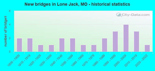
- New bridges - historical statistics
- 21900-1909
- 21910-1919
- 11920-1929
- 11930-1939
- 21940-1949
- 21950-1959
- 11960-1969
- 11970-1979
- 21980-1989
- 31990-1999
- 42000-2009
- 32010-2019
- 12020-2022

- Reconstructed bridges - Historical Statistics
- 11940-1949
- 01950-1959
- 01960-1969
- 21970-1979
- 21980-1989
- 01990-1999
- 02000-2009
- 12010-2019


- Bridge Condition - Deck
- 72.7%Good
- 27.3%Satisfactory

- Bridge Condition - Superstructure
- 81.8%Good
- 18.2%Satisfactory

- Bridge Condition - Substructure
- 9.1%Excellent
- 9.1%Very good
- 36.4%Good
- 45.5%Satisfactory

- Bridge Condition - Channel
- 4.5%Very good
- 13.6%Good
- 40.9%Satisfactory
- 36.4%Fair
- 4.5%Poor

- Bridge Condition - Culverts
- 8.3%Excellent
- 16.7%Good
- 50.0%Satisfactory
- 8.3%Fair
- 16.7%Poor
Find on map >> Show street view
Structure Number: 1296, Location: S 27 T 47 N R 29 W (Lat: 38.847347, Lng: -94.104533), Route carried "on" structure: County highway 25, Year Built: 1900, Year Reconstructed: 1988, Status: Open, Structure Length: 1.98m (6.50ft), Average Daily Traffic: 60 (year 2021), Truck Traffic: 10%, Average Future Daily Traffic: 96 (year 2041), Features Intersected: TRIB OF EAST BR, Facility Carried by Structure: CO RD NW 500
Minimum Vertical Clearance: 30+ m (98+ ft), Kilometerpoint: 1.127, Lanes on structure: 2, Owner: County Highway Agency, Approaching Roadway Width: 5.8m (19.0ft), Material/Design: Steel, Design/Construction: Stringer/Multi-beam, Number Of Spans In Main Unit: 3, Length of Maximum Span: 7.6m (24.9ft), Curb-To-Curb Width: 6.2m (20.3ft), Out-to-Out Width: 6.4m (21.0ft)
Condition: Deck: Good, Superstructure: Good, Substructure: Satisfactory, Channel: Satisfactory, Operating Rating: 32.4 metric tons, Method Used To Determine Operating Rating: Allowable Stress (AS), Inventory Rating: 18.0 metric tons, Method Used To Determine Inventory Rating: Allowable Stress (AS), Structural Evaluation: Somewhat better than minimum adequacy, Deck Geometry: Somewhat better than minimum adequacy, Waterway Adequacy: Better than present minimum criteria, Approach Roadway Alignment: Equal to present desirable criteria, Designated Inspection Frequency: Every 24 months, Inspection Date: November 2020, Deck Structure Type: Concrete Cast-file-Place, Wearing Surface/Protective System: Wearing Surface: Monolithic Concrete
Find on map >> Show street view
Structure Number: 2068, Location: S 35 T 48 N R 30 W (Lat: 38.925914, Lng: -94.193022), Route carried "on" structure: County highway 270, Year Built: 1950, Status: Open, Structure Length: 0.91m (2.99ft), Average Daily Traffic: 87 (year 2021), Truck Traffic: 2%, Average Future Daily Traffic: 131 (year 2041), Features Intersected: BR OF SNI-A-BAR CR, Facility Carried by Structure: CORN RD
Minimum Vertical Clearance: 30+ m (98+ ft), Kilometerpoint: 1.609, Lanes on structure: 2, Owner: County Highway Agency, Approaching Roadway Width: 7.3m (24.0ft), Material/Design: Concrete, Design/Construction: Culvert, Number Of Spans In Main Unit: 1, Length of Maximum Span: 3.7m (12.1ft)
Condition: Channel: Satisfactory, Culverts: Satisfactory, Operating Rating: 49.5 metric tons, Method Used To Determine Operating Rating: Allowable Stress (AS), Inventory Rating: 16.2 metric tons, Method Used To Determine Inventory Rating: Allowable Stress (AS), Structural Evaluation: Somewhat better than minimum adequacy, Waterway Adequacy: Better than present minimum criteria, Approach Roadway Alignment: Equal to present desirable criteria, Designated Inspection Frequency: Every 24 months, Inspection Date: Febuary 2021
Find on map >> Show street view
Structure Number: 20707, Location: S 2 T 47 N R 30 W (Lat: 38.919914, Lng: -94.192350), Route carried "on" structure: County highway 271, Year Built: 1955, Status: Open, Structure Length: 1.01m (3.31ft), Average Daily Traffic: 249 (year 2021), Truck Traffic: 5%, Average Future Daily Traffic: 374 (year 2041), Features Intersected: BR OF SNI-A-BAR CR, Facility Carried by Structure: HAMMOND
Minimum Vertical Clearance: 30+ m (98+ ft), Kilometerpoint: 1.931, Lanes on structure: 2, Owner: County Highway Agency, Approaching Roadway Width: 7.9m (25.9ft), Material/Design: Concrete, Design/Construction: Culvert, Number Of Spans In Main Unit: 2, Length of Maximum Span: 4.0m (13.1ft)
Condition: Channel: Poor, Culverts: Fair, Operating Rating: 49.5 metric tons, Method Used To Determine Operating Rating: Allowable Stress (AS), Inventory Rating: 22.5 metric tons, Method Used To Determine Inventory Rating: Allowable Stress (AS), Structural Evaluation: Somewhat better than minimum adequacy, Waterway Adequacy: Equal to present desirable criteria, Approach Roadway Alignment: Equal to present desirable criteria, Designated Inspection Frequency: Every 24 months, Inspection Date: Febuary 2021
Find on map >> Show street view
Structure Number: 21347, Location: S 6 T 47 N R 29 W (Lat: 38.909847, Lng: -94.157622), Route carried "on" structure: County highway 302, Year Built: 1930, Status: Posted for load, Structure Length: 2.13m (6.99ft), Average Daily Traffic: 200 (year 2021), Truck Traffic: 2%, Average Future Daily Traffic: 300 (year 2041), Features Intersected: BR.OF SNI-A-BAR CR, Facility Carried by Structure: CAVE RD
Minimum Vertical Clearance: 30+ m (98+ ft), Kilometerpoint: 0.966, Lanes on structure: 2, Owner: County Highway Agency, Approaching Roadway Width: 7.3m (24.0ft), Material/Design: Concrete, Design/Construction: Culvert, Number Of Spans In Main Unit: 1, Length of Maximum Span: 14.0m (45.9ft), Curb-To-Curb Width: 12.2m (40.0ft), Out-to-Out Width: 12.8m (42.0ft)
Condition: Channel: Fair, Culverts: Satisfactory, Operating Rating: 49.5 metric tons, Method Used To Determine Operating Rating: Allowable Stress (AS), Inventory Rating: 16.2 metric tons, Method Used To Determine Inventory Rating: Allowable Stress (AS), Structural Evaluation: Somewhat better than minimum adequacy, Deck Geometry: Superior to present desirable criteria, Waterway Adequacy: Equal to present minimum criteria, Approach Roadway Alignment: Equal to present desirable criteria, Designated Inspection Frequency: Every 24 months, Inspection Date: Febuary 2021
Find on map >> Show street view
Structure Number: 21381, Location: S 4 T 47 N R 29 W (Lat: 38.914344, Lng: -94.121231), Route carried "on" structure: County highway 304, Year Built: 2000, Status: Open, Structure Length: 1.07m (3.51ft), Average Daily Traffic: 121 (year 2021), Truck Traffic: 9%, Average Future Daily Traffic: 182 (year 2041), Features Intersected: BR.OF SNI-A-BAR CR, Facility Carried by Structure: TAPSCOTT RD
Minimum Vertical Clearance: 30+ m (98+ ft), Kilometerpoint: 0.483, Lanes on structure: 2, Owner: County Highway Agency, Approaching Roadway Width: 8.5m (27.9ft), Material/Design: Concrete, Design/Construction: Slab, Number Of Spans In Main Unit: 1, Length of Maximum Span: 9.8m (32.2ft), Curb-To-Curb Width: 8.5m (27.9ft), Out-to-Out Width: 8.7m (28.5ft)
Condition: Deck: Good, Superstructure: Good, Substructure: Good, Channel: Good, Operating Rating: 54.0 metric tons, Method Used To Determine Operating Rating: Load Factor (LF), Inventory Rating: 32.4 metric tons, Method Used To Determine Inventory Rating: Load Factor (LF), Structural Evaluation: Better than present minimum criteria, Deck Geometry: Equal to present minimum criteria, Waterway Adequacy: Better than present minimum criteria, Approach Roadway Alignment: Equal to present desirable criteria, Designated Inspection Frequency: Every 24 months, Inspection Date: Febuary 2021, Deck Structure Type: Concrete Cast-file-Place, Wearing Surface/Protective System: Wearing Surface: Integral Concrete
Find on map >> Show street view
Structure Number: 21476, Location: S 5 T 47 N R 29 W (Lat: 38.912700, Lng: -94.142822), Route carried "on" structure: County highway 308, Year Built: 1976, Status: Open, Structure Length: 1.77m (5.81ft), Average Daily Traffic: 77 (year 2021), Truck Traffic: 2%, Average Future Daily Traffic: 116 (year 2041), Design Load: H 20, Features Intersected: BR OF SNI-A-BAR CR, Facility Carried by Structure: HUNT RD
Minimum Vertical Clearance: 30+ m (98+ ft), Kilometerpoint: 0.644, Lanes on structure: 2, Owner: County Highway Agency, Approaching Roadway Width: 7.3m (24.0ft), Material/Design: Prestressed concrete, Design/Construction: Tee Beam, Number Of Spans In Main Unit: 1, Length of Maximum Span: 14.9m (48.9ft), Curb-To-Curb Width: 8.5m (27.9ft), Out-to-Out Width: 9.1m (29.9ft)
Condition: Deck: Good, Superstructure: Good, Substructure: Very good, Channel: Good, Operating Rating: 45.0 metric tons, Method Used To Determine Operating Rating: Allowable Stress (AS), Inventory Rating: 20.7 metric tons, Method Used To Determine Inventory Rating: Allowable Stress (AS), Structural Evaluation: Equal to present minimum criteria, Deck Geometry: Better than present minimum criteria, Waterway Adequacy: Equal to present minimum criteria, Approach Roadway Alignment: Equal to present desirable criteria, Designated Inspection Frequency: Every 24 months, Inspection Date: Febuary 2021, Deck Structure Type: Concrete Cast-file-Place, Wearing Surface/Protective System: Wearing Surface: Monolithic Concrete
Find on map >> Show street view
Structure Number: 21493, Location: S 7 T 47 N R 29 W (Lat: 38.901158, Lng: -94.169733), Route carried "on" structure: County highway 309, Year Built: 1993, Status: Open, Structure Length: 1.19m (3.90ft), Average Daily Traffic: 234 (year 2021), Truck Traffic: 2%, Average Future Daily Traffic: 351 (year 2041), Design Load: HS 20, Features Intersected: SMALL CR, Facility Carried by Structure: SNOW RD
Minimum Vertical Clearance: 30+ m (98+ ft), Kilometerpoint: 0.483, Lanes on structure: 2, Owner: County Highway Agency, Approaching Roadway Width: 9.8m (32.2ft), Skew: 3 degrees, Material/Design: Concrete, Design/Construction: Slab, Number Of Spans In Main Unit: 1, Length of Maximum Span: 11.0m (36.1ft), Curb-To-Curb Width: 11.0m (36.1ft), Out-to-Out Width: 14.5m (47.6ft)
Condition: Deck: Good, Superstructure: Good, Substructure: Satisfactory, Channel: Satisfactory, Operating Rating: 54.0 metric tons, Method Used To Determine Operating Rating: Allowable Stress (AS), Inventory Rating: 32.4 metric tons, Method Used To Determine Inventory Rating: Allowable Stress (AS), Structural Evaluation: Equal to present minimum criteria, Deck Geometry: Equal to present desirable criteria, Waterway Adequacy: Better than present minimum criteria, Approach Roadway Alignment: Equal to present desirable criteria, Designated Inspection Frequency: Every 24 months, Inspection Date: Febuary 2021
Find on map >> Show street view
Structure Number: 21501, Location: S 7 T 47 N R 29 W (Lat: 38.900878, Lng: -94.159978), Route carried "on" structure: County highway 309, Year Built: 1988, Status: Open, Structure Length: 0.85m (2.79ft), Average Daily Traffic: 234 (year 2021), Truck Traffic: 2%, Average Future Daily Traffic: 351 (year 2041), Features Intersected: SMALL CR, Facility Carried by Structure: FAULKENBERRY RD
Minimum Vertical Clearance: 30+ m (98+ ft), Kilometerpoint: 1.287, Lanes on structure: 2, Owner: County Highway Agency, Approaching Roadway Width: 7.3m (24.0ft), Material/Design: Concrete, Design/Construction: Culvert, Number Of Spans In Main Unit: 1, Length of Maximum Span: 7.6m (24.9ft)
Condition: Channel: Satisfactory, Culverts: Satisfactory, Operating Rating: 49.5 metric tons, Method Used To Determine Operating Rating: Allowable Stress (AS), Inventory Rating: 32.4 metric tons, Method Used To Determine Inventory Rating: Allowable Stress (AS), Structural Evaluation: Equal to present minimum criteria, Waterway Adequacy: Better than present minimum criteria, Approach Roadway Alignment: Equal to present desirable criteria, Designated Inspection Frequency: Every 24 months, Inspection Date: Febuary 2021
Find on map >> Show street view
Structure Number: 21639, Location: S 33 T 47 N R 29 W (Lat: 38.838772, Lng: -94.118458), Route carried "on" structure: County highway 316, Year Built: 1997, Status: Open, Structure Length: 1.19m (3.90ft), Average Daily Traffic: 500 (year 2021), Truck Traffic: 5%, Average Future Daily Traffic: 750 (year 2041), Design Load: HS 20, Features Intersected: SMALL CR, Facility Carried by Structure: JOHNSON CNTY LINE
Minimum Vertical Clearance: 30+ m (98+ ft), Kilometerpoint: 1.609, Lanes on structure: 2, Owner: County Highway Agency, Approaching Roadway Width: 7.3m (24.0ft), Skew: 1 degrees, Material/Design: Steel, Design/Construction: Stringer/Multi-beam, Number Of Spans In Main Unit: 1, Length of Maximum Span: 11.3m (37.1ft), Curb-To-Curb Width: 7.3m (24.0ft), Out-to-Out Width: 7.3m (24.0ft)
Condition: Deck: Satisfactory, Superstructure: Satisfactory, Substructure: Satisfactory, Channel: Satisfactory, Operating Rating: 54.0 metric tons, Method Used To Determine Operating Rating: Load Factor (LF), Inventory Rating: 32.4 metric tons, Method Used To Determine Inventory Rating: Load Factor (LF), Structural Evaluation: Equal to present minimum criteria, Deck Geometry: Meets minimum limits, Waterway Adequacy: Superior to present desirable criteria, Approach Roadway Alignment: Equal to present desirable criteria, Designated Inspection Frequency: Every 24 months, Inspection Date: Febuary 2021, Deck Structure Type: Concrete Cast-file-Place
Find on map >> Show street view
Structure Number: 21677, Location: S 28 T 47 N R 29 W (Lat: 38.851653, Lng: -94.121458), Route carried "on" structure: County highway 316, Year Built: 1945, Year Reconstructed: 1989, Status: Open, Structure Length: 1.04m (3.41ft), Average Daily Traffic: 415 (year 2021), Truck Traffic: 2%, Average Future Daily Traffic: 623 (year 2041), Design Load: HS 20, Features Intersected: SMALL CR, Facility Carried by Structure: BOSWELL RD
Minimum Vertical Clearance: 30+ m (98+ ft), Kilometerpoint: 2.092, Lanes on structure: 2, Owner: County Highway Agency, Approaching Roadway Width: 9.8m (32.2ft), Skew: 4 degrees, Material/Design: Concrete, Design/Construction: Slab, Number Of Spans In Main Unit: 1, Length of Maximum Span: 7.3m (24.0ft), Curb-To-Curb Width: 10.8m (35.4ft), Out-to-Out Width: 11.4m (37.4ft)
Condition: Deck: Satisfactory, Superstructure: Satisfactory, Substructure: Good, Channel: Fair, Operating Rating: 49.5 metric tons, Method Used To Determine Operating Rating: Allowable Stress (AS), Inventory Rating: 32.4 metric tons, Method Used To Determine Inventory Rating: Allowable Stress (AS), Structural Evaluation: Equal to present minimum criteria, Deck Geometry: Equal to present minimum criteria, Waterway Adequacy: Somewhat better than minimum adequacy, Approach Roadway Alignment: Equal to present desirable criteria, Designated Inspection Frequency: Every 24 months, Inspection Date: Febuary 2021, Deck Structure Type: Concrete Cast-file-Place, Wearing Surface/Protective System: Wearing Surface: Bituminous
Find on map >> Show street view
Structure Number: 21749, Location: S 31 T 47 N R 29 W (Lat: 38.844967, Lng: -94.156067), Route carried "on" structure: County highway 322, Year Built: 1966, Year Reconstructed: 2018, Status: Open, Structure Length: 0.91m (2.99ft), Average Daily Traffic: 60 (year 2021), Truck Traffic: 2%, Average Future Daily Traffic: 90 (year 2041), Design Load: H 10, Features Intersected: SMALL CR, Facility Carried by Structure: MILLER RD
Minimum Vertical Clearance: 30+ m (98+ ft), Kilometerpoint: 1.127, Lanes on structure: 2, Owner: County Highway Agency, Approaching Roadway Width: 5.7m (18.7ft), Skew: 3 degrees, Material/Design: Concrete, Design/Construction: Culvert, Number Of Spans In Main Unit: 2, Length of Maximum Span: 3.4m (11.2ft)
Condition: Channel: Satisfactory, Culverts: Satisfactory, Operating Rating: 44.1 metric tons, Method Used To Determine Operating Rating: Allowable Stress (AS), Inventory Rating: 32.4 metric tons, Method Used To Determine Inventory Rating: Allowable Stress (AS), Structural Evaluation: Equal to present minimum criteria, Waterway Adequacy: Better than present minimum criteria, Approach Roadway Alignment: Equal to present desirable criteria, Designated Inspection Frequency: Every 24 months, Inspection Date: Febuary 2021
Find on map >> Show street view
Structure Number: 21771, Location: S 32 T 47 N R 29 W (Lat: 38.833933, Lng: -94.146119), Route carried "on" structure: County highway 323, Year Built: 1900, Year Reconstructed: 1982, Status: Open, Structure Length: 0.88m (2.89ft), Average Daily Traffic: 99 (year 2021), Truck Traffic: 2%, Average Future Daily Traffic: 149 (year 2041), Design Load: HS 20, Features Intersected: E FK CRAWFORD CR, Facility Carried by Structure: COUNTY LINE RD
Minimum Vertical Clearance: 30+ m (98+ ft), Kilometerpoint: 0.805, Lanes on structure: 2, Owner: County Highway Agency, Approaching Roadway Width: 7.9m (25.9ft), Material/Design: Concrete, Design/Construction: Culvert, Number Of Spans In Main Unit: 1, Length of Maximum Span: 4.3m (14.1ft)
Condition: Channel: Fair, Culverts: Satisfactory, Operating Rating: 44.1 metric tons, Method Used To Determine Operating Rating: Allowable Stress (AS), Inventory Rating: 32.4 metric tons, Method Used To Determine Inventory Rating: Allowable Stress (AS), Structural Evaluation: Equal to present minimum criteria, Waterway Adequacy: Better than present minimum criteria, Approach Roadway Alignment: Equal to present desirable criteria, Designated Inspection Frequency: Every 24 months, Inspection Date: Febuary 2021
Find on map >> Show street view
Structure Number: 21891, Location: S 12 T 47 N R 30 W (Lat: 38.898706, Lng: -94.176414), Route carried "on" structure: County highway 329, Year Built: 1940, Status: Open, Structure Length: 0.64m (2.10ft), Average Daily Traffic: 147 (year 2021), Truck Traffic: 2%, Average Future Daily Traffic: 221 (year 2041), Features Intersected: BR OF SNI-A-BAR CR, Facility Carried by Structure: HELMIG RD
Minimum Vertical Clearance: 30+ m (98+ ft), Kilometerpoint: 1.127, Lanes on structure: 2, Owner: County Highway Agency, Approaching Roadway Width: 6.7m (22.0ft), Skew: 1 degrees, Material/Design: Concrete, Design/Construction: Culvert, Number Of Spans In Main Unit: 2, Length of Maximum Span: 3.0m (9.8ft)
Condition: Channel: Fair, Culverts: Poor, Operating Rating: 49.5 metric tons, Method Used To Determine Operating Rating: Allowable Stress (AS), Inventory Rating: 16.2 metric tons, Method Used To Determine Inventory Rating: Allowable Stress (AS), Structural Evaluation: Meets minimum limits, Waterway Adequacy: Better than present minimum criteria, Approach Roadway Alignment: Equal to present desirable criteria, Length Of Structure Improvement: 0.13m (0.43ft), Designated Inspection Frequency: Every 24 months, Inspection Date: Febuary 2021, Bridge Improvement Cost: $85,000, Roadway Improvement Cost: $9,000, Total Project Cost: $128,000 ( Estimate for 2022)
Find on map >> Show street view
Structure Number: 21911, Location: S 36 T 48 N R 30 W (Lat: 38.930842, Lng: -94.183519), Route carried "on" structure: County highway 330, Year Built: 1984, Status: Open, Structure Length: 0.64m (2.10ft), Average Daily Traffic: 152 (year 2021), Truck Traffic: 5%, Average Future Daily Traffic: 228 (year 2041), Design Load: HS 20, Features Intersected: BR OF SNI-A-BAR CR, Facility Carried by Structure: GIBSON RD
Minimum Vertical Clearance: 30+ m (98+ ft), Kilometerpoint: 0.805, Lanes on structure: 2, Owner: County Highway Agency, Approaching Roadway Width: 5.5m (18.0ft), Material/Design: Concrete, Design/Construction: Slab, Number Of Spans In Main Unit: 1, Length of Maximum Span: 6.4m (21.0ft), Curb-To-Curb Width: 8.5m (27.9ft), Out-to-Out Width: 9.4m (30.8ft)
Condition: Deck: Good, Superstructure: Good, Substructure: Good, Channel: Fair, Operating Rating: 49.5 metric tons, Method Used To Determine Operating Rating: Allowable Stress (AS), Inventory Rating: 16.2 metric tons, Method Used To Determine Inventory Rating: Allowable Stress (AS), Structural Evaluation: Somewhat better than minimum adequacy, Deck Geometry: Equal to present minimum criteria, Waterway Adequacy: Better than present minimum criteria, Approach Roadway Alignment: Equal to present desirable criteria, Designated Inspection Frequency: Every 24 months, Inspection Date: Febuary 2021, Deck Structure Type: Concrete Cast-file-Place, Wearing Surface/Protective System: Wearing Surface: Bituminous
Find on map >> Show street view
Structure Number: 21913, Location: S 36 T 48 N R 30 W (Lat: 38.930483, Lng: -94.183572), Route carried "on" structure: County highway 330, Year Built: 1915, Year Reconstructed: 1984, Status: Open, Structure Length: 0.91m (2.99ft), Average Daily Traffic: 152 (year 2021), Truck Traffic: 5%, Average Future Daily Traffic: 228 (year 2041), Design Load: HS 20, Features Intersected: BR OF SNI-A-BAR CR, Facility Carried by Structure: GIBSON RD
Minimum Vertical Clearance: 30+ m (98+ ft), Kilometerpoint: 0.966, Lanes on structure: 2, Owner: County Highway Agency, Approaching Roadway Width: 5.5m (18.0ft), Material/Design: Concrete, Design/Construction: Slab, Number Of Spans In Main Unit: 1, Length of Maximum Span: 9.1m (29.9ft), Curb-To-Curb Width: 8.5m (27.9ft), Out-to-Out Width: 9.1m (29.9ft)
Condition: Deck: Good, Superstructure: Good, Substructure: Good, Channel: Satisfactory, Operating Rating: 54.0 metric tons, Method Used To Determine Operating Rating: Allowable Stress (AS), Inventory Rating: 30.6 metric tons, Method Used To Determine Inventory Rating: Allowable Stress (AS), Structural Evaluation: Better than present minimum criteria, Deck Geometry: Equal to present minimum criteria, Waterway Adequacy: Better than present minimum criteria, Approach Roadway Alignment: Equal to present desirable criteria, Designated Inspection Frequency: Every 24 months, Inspection Date: Febuary 2021, Deck Structure Type: Concrete Cast-file-Place, Wearing Surface/Protective System: Wearing Surface: Bituminous
Find on map >> Show street view
Structure Number: 22333, Location: S 2 T 47 N R 30 W (Lat: 38.908744, Lng: -94.203819), Route carried "on" structure: County highway 351, Year Built: 1998, Status: Posted for load, Structure Length: 0.82m (2.69ft), Average Daily Traffic: 73 (year 2021), Truck Traffic: 10%, Average Future Daily Traffic: 110 (year 2041), Design Load: HS 20, Features Intersected: PRAIRIE CR, Facility Carried by Structure: BROWN RD
Minimum Vertical Clearance: 30+ m (98+ ft), Kilometerpoint: 1.127, Lanes on structure: 2, Owner: County Highway Agency, Approaching Roadway Width: 9.8m (32.2ft), Material/Design: Concrete continuous, Design/Construction: Culvert, Number Of Spans In Main Unit: 1, Length of Maximum Span: 6.1m (20.0ft), Curb-To-Curb Width: 9.8m (32.2ft), Out-to-Out Width: 10.4m (34.1ft)
Condition: Channel: Satisfactory, Culverts: Good, Operating Rating: 20.7 metric tons, Method Used To Determine Operating Rating: Load Factor (LF), Inventory Rating: 12.6 metric tons, Method Used To Determine Inventory Rating: Load Factor (LF), Structural Evaluation: Meets minimum limits, Deck Geometry: Equal to present desirable criteria, Waterway Adequacy: Better than present minimum criteria, Approach Roadway Alignment: Equal to present desirable criteria, Designated Inspection Frequency: Every 24 months, Inspection Date: Febuary 2021, Deck Structure Type: Concrete Cast-file-Place, Wearing Surface/Protective System: Wearing Surface: Gravel
Find on map >> Show street view
Structure Number: 28605, Location: S 4 T 46 N R 29 W (Lat: 38.818783, Lng: -94.134900), Route carried "on" structure: County highway 126, Year Built: 2000, Status: Open, Structure Length: 1.68m (5.51ft), Average Daily Traffic: 40 (year 2021), Truck Traffic: 10%, Average Future Daily Traffic: 64 (year 2041), Features Intersected: EAST BR, Facility Carried by Structure: 163 ST
Minimum Vertical Clearance: 30+ m (98+ ft), Kilometerpoint: 1.609, Lanes on structure: 2, Owner: County Highway Agency, Approaching Roadway Width: 6.1m (20.0ft), Material/Design: Steel, Design/Construction: Stringer/Multi-beam, Number Of Spans In Main Unit: 1, Length of Maximum Span: 15.5m (50.9ft), Curb-To-Curb Width: 7.2m (23.6ft), Out-to-Out Width: 7.4m (24.3ft)
Condition: Deck: Good, Superstructure: Good, Substructure: Satisfactory, Channel: Fair, Operating Rating: 52.2 metric tons, Method Used To Determine Operating Rating: Load Factor (LF), Inventory Rating: 31.5 metric tons, Method Used To Determine Inventory Rating: Load Factor (LF), Structural Evaluation: Equal to present minimum criteria, Deck Geometry: Somewhat better than minimum adequacy, Waterway Adequacy: Better than present minimum criteria, Approach Roadway Alignment: Equal to present minimum criteria, Designated Inspection Frequency: Every 24 months, Inspection Date: April 2021, Deck Structure Type: Concrete Cast-file-Place
Find on map >> Show street view
Structure Number: 28606, Location: S 4 T 46 N R 29 W (Lat: 38.822050, Lng: -94.125233), Route carried "on" structure: County highway 126, Year Built: 2000, Status: Open, Structure Length: 2.10m (6.89ft), Average Daily Traffic: 40 (year 2021), Truck Traffic: 10%, Average Future Daily Traffic: 64 (year 2041), Features Intersected: BR OF EAST CR, Facility Carried by Structure: 161 ST
Minimum Vertical Clearance: 30+ m (98+ ft), Kilometerpoint: 2.736, Lanes on structure: 2, Owner: County Highway Agency, Approaching Roadway Width: 7.3m (24.0ft), Material/Design: Steel, Design/Construction: Stringer/Multi-beam, Number Of Spans In Main Unit: 1, Length of Maximum Span: 19.8m (65.0ft), Curb-To-Curb Width: 7.2m (23.6ft), Out-to-Out Width: 7.3m (24.0ft)
Condition: Deck: Good, Superstructure: Good, Substructure: Satisfactory, Channel: Fair, Operating Rating: 40.5 metric tons, Method Used To Determine Operating Rating: Load Factor (LF), Inventory Rating: 23.4 metric tons, Method Used To Determine Inventory Rating: Load Factor (LF), Structural Evaluation: Equal to present minimum criteria, Deck Geometry: Somewhat better than minimum adequacy, Waterway Adequacy: Better than present minimum criteria, Approach Roadway Alignment: Equal to present minimum criteria, Designated Inspection Frequency: Every 24 months, Inspection Date: April 2021, Deck Structure Type: Concrete Cast-file-Place
Find on map >> Show street view
Structure Number: 30781, Location: S 7 T 47 N R 29 W (Lat: 38.893581, Lng: -94.161878), Route carried "on" structure: County highway 310, Year Built: 2003, Status: Open, Structure Length: 0.67m (2.20ft), Average Daily Traffic: 20 (year 2021), Truck Traffic: 5%, Average Future Daily Traffic: 30 (year 2041), Design Load: HS 25 or greater, Features Intersected: BR OF SNI-A-BAR CR, Facility Carried by Structure: BYNUM SPUR RD
Minimum Vertical Clearance: 30+ m (98+ ft), Kilometerpoint: 0.483, Lanes on structure: 2, Owner: County Highway Agency, Approaching Roadway Width: 6.4m (21.0ft), Material/Design: Concrete, Design/Construction: Culvert, Number Of Spans In Main Unit: 1, Length of Maximum Span: 6.1m (20.0ft), Curb-To-Curb Width: 8.5m (27.9ft), Out-to-Out Width: 9.8m (32.2ft)
Condition: Channel: Good, Culverts: Good, Operating Rating: 69.3 metric tons, Method Used To Determine Operating Rating: Load Factor (LF), Inventory Rating: 41.4 metric tons, Method Used To Determine Inventory Rating: Load Factor (LF), Structural Evaluation: Better than present minimum criteria, Deck Geometry: Better than present minimum criteria, Waterway Adequacy: Better than present minimum criteria, Approach Roadway Alignment: Equal to present desirable criteria, Designated Inspection Frequency: Every 24 months, Inspection Date: Febuary 2021
Find on map >> Show street view
Structure Number: 32912, Location: S 19 T 47 N R 29 W (Lat: 38.868422, Lng: -94.173361), Route carried "on" structure: State highway 150, Year Built: 2010, Status: Open, Structure Length: 4.51m (14.80ft), Average Daily Traffic: 1,705 (year 2021), Truck Traffic: 9%, Average Future Daily Traffic: 2,387 (year 2041), Features Intersected: US 50
Minimum Vertical Clearance: 30+ m (98+ ft), Kilometerpoint: 41.114, Lanes on structure: 6, Lanes under structure: 4, Owner: State Highway Agency, Approaching Roadway Width: 12.2m (40.0ft), Skew: 1 degrees, Material/Design: Prestressed concrete continuous, Design/Construction: Box Beam or Girders - Multiple, Number Of Spans In Main Unit: 2, Length of Maximum Span: 22.3m (73.2ft), Curb-To-Curb Width: 12.2m (40.0ft), Out-to-Out Width: 14.8m (48.6ft)
Condition: Deck: Satisfactory, Superstructure: Good, Substructure: Excellent, Inventory Rating: 66.6 metric tons, Method Used To Determine Inventory Rating: Load Factor (LF), Structural Evaluation: Better than present minimum criteria, Deck Geometry: High priority of replacement, Underclear: Somewhat better than minimum adequacy, Approach Roadway Alignment: Equal to present desirable criteria, Length Of Structure Improvement: 0.55m (1.80ft), Designated Inspection Frequency: Every 24 months, Inspection Date: October 2021, Bridge Improvement Cost: $999,000, Roadway Improvement Cost: $100,000, Total Project Cost: $1,498,000 ( Estimate for 2022), Deck Structure Type: Concrete Cast-file-Place, Wearing Surface/Protective System: Wearing Surface: Monolithic Concrete, Deck Protection: Epoxy Coated Reinforcing
Find on map >> Show street view
Structure Number: 36479, Location: S 31 T 47 N R 29 W (Lat: 38.844967, Lng: -94.156067), Route carried "on" structure: County highway 322, Year Built: 2022, Status: Not yet open, Structure Length: 0.80m (2.62ft), Average Daily Traffic: 60 (year 2021), Truck Traffic: 10%, Average Future Daily Traffic: 90 (year 2041), Design Load: HS 20, Features Intersected: SMALL CREEK, Facility Carried by Structure: SOUTH MILLER ROAD
Minimum Vertical Clearance: 30+ m (98+ ft), Kilometerpoint: 1.127, Lanes on structure: 2, Owner: County Highway Agency, Approaching Roadway Width: 6.1m (20.0ft), Skew: 3 degrees, Material/Design: Concrete continuous, Design/Construction: Culvert, Number Of Spans In Main Unit: 2, Length of Maximum Span: 3.5m (11.5ft), Curb-To-Curb Width: 6.1m (20.0ft), Out-to-Out Width: 6.1m (20.0ft)
Condition: Channel: Very good, Culverts: Excellent, Operating Rating: 54.0 metric tons, Method Used To Determine Operating Rating: Load Factor (LF), Inventory Rating: 32.4 metric tons, Method Used To Determine Inventory Rating: Load Factor (LF), Structural Evaluation: Equal to present desirable criteria, Deck Geometry: Somewhat better than minimum adequacy, Waterway Adequacy: Equal to present desirable criteria, Approach Roadway Alignment: Equal to present desirable criteria, Designated Inspection Frequency: Every 24 months, Inspection Date: December 2020
Find on map >> Show street view
Structure Number: 4672, Location: S 22 T 47 N R 29 W (Lat: 38.869453, Lng: -94.102283), Route carried "on" structure: US 50, Year Built: 1922, Year Reconstructed: 1951, Status: Open, Structure Length: 0.84m (2.76ft), Average Daily Traffic: 6,608 (year 2021), Truck Traffic: 11%, Average Future Daily Traffic: 11,564 (year 2041), Design Load: H 20, Features Intersected: ROBINSON BR
Minimum Vertical Clearance: 30+ m (98+ ft), Kilometerpoint: 374.398, Lanes on structure: 2, Base Highway Network: Yes, Owner: State Highway Agency, Approaching Roadway Width: 13.4m (44.0ft), Skew: 2 degrees, Material/Design: Concrete continuous, Design/Construction: Culvert, Number Of Spans In Main Unit: 2, Length of Maximum Span: 3.7m (12.1ft), Curb-To-Curb Width: 14.0m (45.9ft), Out-to-Out Width: 14.6m (47.9ft)
Condition: Channel: Satisfactory, Culverts: Satisfactory, Operating Rating: 81.0 metric tons, Method Used To Determine Operating Rating: Load Factor (LF), Inventory Rating: 48.6 metric tons, Method Used To Determine Inventory Rating: Load Factor (LF), Structural Evaluation: Equal to present minimum criteria, Deck Geometry: Superior to present desirable criteria, Waterway Adequacy: Equal to present minimum criteria, Approach Roadway Alignment: Equal to present desirable criteria, Designated Inspection Frequency: Every 24 months, Inspection Date: December 2020
Find on map >> Show street view
Structure Number: 9933, Location: S 4 T 47 N R 29 W (Lat: 38.911236, Lng: -94.133308), Route carried "on" structure: State highway F, Year Built: 1910, Status: Open, Structure Length: 2.13m (6.99ft), Average Daily Traffic: 3,667 (year 2021), Truck Traffic: 11%, Average Future Daily Traffic: 5,134 (year 2041), Design Load: H 15, Features Intersected: PHILLIPS CR
Minimum Vertical Clearance: 30+ m (98+ ft), Kilometerpoint: 11.832, Lanes on structure: 2, Owner: State Highway Agency, Approaching Roadway Width: 7.3m (24.0ft), Material/Design: Concrete, Design/Construction: Culvert, Number Of Spans In Main Unit: 1, Length of Maximum Span: 12.2m (40.0ft), Curb-To-Curb Width: 12.2m (40.0ft), Out-to-Out Width: 12.8m (42.0ft)
Condition: Channel: Fair, Culverts: Poor, Operating Rating: 36.9 metric tons, Method Used To Determine Operating Rating: Allowable Stress (AS), Inventory Rating: 12.6 metric tons, Method Used To Determine Inventory Rating: Allowable Stress (AS), Structural Evaluation: Meets minimum limits, Deck Geometry: Equal to present minimum criteria, Waterway Adequacy: Equal to present desirable criteria, Approach Roadway Alignment: Equal to present minimum criteria, Length Of Structure Improvement: 0.29m (0.95ft), Designated Inspection Frequency: Every 24 months, Inspection Date: November 2021, Bridge Improvement Cost: $250,000, Roadway Improvement Cost: $25,000, Total Project Cost: $375,000 ( Estimate for 2022), Deck Structure Type: Concrete Cast-file-Place, Wearing Surface/Protective System: Wearing Surface: Bituminous, Membrane: Built-up
Find on map >> Show street view
Structure Number: 32912, Location: S 19 T 47 N R 29 W (Lat: 38.868422, Lng: -94.173361), Route carried "under" structure: US 50, Year Built: 2010, Structure Length: 0. m, Average Daily Traffic: 10,133 (year 2021), Truck Traffic: 13%, Features Intersected: US 50
Minimum Vertical Clearance: 5.00m (16.40ft), Kilometerpoint: 380.591, Lanes on structure: 6, Lanes under structure: 2, Material/Design: Prestressed concrete continuous, Design/Construction: Box Beam or Girders - Multiple, Length of Maximum Span: 22.3m (73.2ft)
Find on map >> Show street view
Structure Number: 32912, Location: S 19 T 47 N R 29 W (Lat: 38.868422, Lng: -94.173361), Route carried "under" structure: US 50, Year Built: 2010, Structure Length: 0. m, Average Daily Traffic: 13,539 (year 2021), Truck Traffic: 8%, Features Intersected: US 50
Minimum Vertical Clearance: 4.98m (16.34ft), Kilometerpoint: 40.811, Lanes on structure: 6, Lanes under structure: 2, Material/Design: Prestressed concrete continuous, Design/Construction: Box Beam or Girders - Multiple, Length of Maximum Span: 22.3m (73.2ft)