Bridge Statistics for Lorton, Virginia (VA)
Condition, Traffic, Stress, Structural Evaluation, Project Costs
- National Bridge Inventory (NBI) Statistics
- 39Number of bridges
- 322ft / 98.1mTotal length
- $8,501,000Total costs
- 1,344,821Total average daily traffic
- 79,870Total average daily truck traffic
- National Bridge Inventory (NBI) Registered Bridges for Lorton
- No street view available for this location
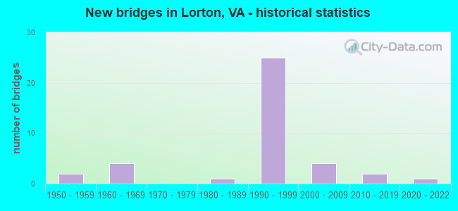
- New bridges - historical statistics
- 21950-1959
- 41960-1969
- 11980-1989
- 251990-1999
- 42000-2009
- 22010-2019
- 12020-2022


- Bridge Condition - Deck
- 5.0%Excellent
- 90.0%Good
- 5.0%Satisfactory

- Bridge Condition - Superstructure
- 4.3%Excellent
- 8.7%Very good
- 65.2%Good
- 13.0%Satisfactory
- 4.3%Fair
- 4.3%Serious

- Bridge Condition - Substructure
- 4.3%Excellent
- 13.0%Very good
- 60.9%Good
- 13.0%Satisfactory
- 8.7%Fair

- Bridge Condition - Channel
- 36.4%Very good
- 18.2%Good
- 18.2%Satisfactory
- 27.3%Fair
Find on map >> Show street view
Structure Number: 6221, Location: 00.07 748 / 00.17 5550 (Lat: 38.701197, Lng: -77.210000), Route carried "on" structure: US 1, Year Built: 1989, Status: Open, Structure Length: 2.50m (8.20ft), Average Daily Traffic: 33,825 (year 2020), Truck Traffic: 3%, Average Future Daily Traffic: 37,208 (year 2040), Design Load: HS 20, Features Intersected: POHICK CREEK, Facility Carried by Structure: JEFF DAVIS HIGHWAY
Minimum Vertical Clearance: 30+ m (98+ ft), Kilometerpoint: 289.153, Lanes on structure: 6, Base Highway Network: Yes, Owner: State Highway Agency, Approaching Roadway Width: 17.1m (56.1ft), Material/Design: Prestressed concrete, Design/Construction: Box Beam or Girders - Multiple, Number Of Spans In Main Unit: 2, Length of Maximum Span: 12.5m (41.0ft), Curb or Sidewalk Widths: Left: 2.6m (8.5ft), Right: 2.6m (8.5ft), Curb-To-Curb Width: 28.7m (94.2ft), Out-to-Out Width: 34.1m (111.9ft)
Condition: Deck: Good, Superstructure: Good, Substructure: Satisfactory, Channel: Fair, Operating Rating: 70.4 metric tons, Method Used To Determine Operating Rating: Load and Resistance Factor (LRFR), Inventory Rating: 54.2 metric tons, Method Used To Determine Inventory Rating: Load and Resistance Factor (LRFR), Structural Evaluation: Equal to present minimum criteria, Deck Geometry: Superior to present desirable criteria, Waterway Adequacy: Better than present minimum criteria, Approach Roadway Alignment: Equal to present desirable criteria, Length Of Structure Improvement: 2.50m (8.20ft), Designated Inspection Frequency: Every 24 months, Inspection Date: August 2021, Bridge Improvement Cost: $150,000, Roadway Improvement Cost: $150,000, Total Project Cost: $500,000, Deck Structure Type: Concrete Cast-file-Place, Wearing Surface/Protective System: Wearing Surface: Bituminous
Find on map >> Show street view
Structure Number: 6222, Location: 00.06 3180 / 00.99 611 (Lat: 38.679839, Lng: -77.226297), Route carried "on" structure: US 1, Year Built: 1994, Status: Open, Structure Length: 1.04m (3.41ft), Average Daily Traffic: 33,995 (year 2020), Truck Traffic: 3%, Average Future Daily Traffic: 37,394 (year 2040), Design Load: HS 20, Features Intersected: GILES RUN, Facility Carried by Structure: JEFFERSON DAVIS HY
Minimum Vertical Clearance: 30+ m (98+ ft), Kilometerpoint: 286.379, Lanes on structure: 6, Base Highway Network: Yes, Owner: State Highway Agency, Approaching Roadway Width: 31.1m (102.0ft), Skew: 22 degrees, Material/Design: Concrete, Design/Construction: Culvert, Number Of Spans In Main Unit: 3, Length of Maximum Span: 3.0m (9.8ft)
Condition: Channel: Satisfactory, Culverts: Good, Operating Rating: 64.4 metric tons, Method Used To Determine Operating Rating: Load Factor (LF), Inventory Rating: 38.1 metric tons, Method Used To Determine Inventory Rating: Load Factor (LF), Structural Evaluation: Better than present minimum criteria, Waterway Adequacy: Equal to present minimum criteria, Approach Roadway Alignment: Equal to present desirable criteria, Length Of Structure Improvement: 1.04m (3.41ft), Designated Inspection Frequency: Every 24 months, Inspection Date: April 2021, Bridge Improvement Cost: $50,000, Roadway Improvement Cost: $1,000, Total Project Cost: $55,000 ( Estimate for 2015)
Find on map >> Show street view
Structure Number: 6389, Location: 2.41 Fr 642 & 0.68 To 123 (Lat: 38.674264, Lng: -77.240328), Route carried "on" structure: Interstate 95, Year Built: 1962, Status: Open, Structure Length: 3.54m (11.61ft), Average Daily Traffic: 81,442 (year 2020), Truck Traffic: 7%, Average Future Daily Traffic: 114,019 (year 2040), Design Load: HS 20, Features Intersected: FURNACE RD & ROUTE 611
Minimum Vertical Clearance: 30+ m (98+ ft), Kilometerpoint: 260.320, Lanes on structure: 4, Lanes under structure: 2, Base Highway Network: Yes, Owner: State Highway Agency, Approaching Roadway Width: 35.4m (116.1ft), Material/Design: Steel, Design/Construction: Stringer/Multi-beam, Number Of Spans In Main Unit: 3, Length of Maximum Span: 12.8m (42.0ft), Curb-To-Curb Width: 20.3m (66.6ft), Out-to-Out Width: 21.3m (69.9ft)
Condition: Deck: Satisfactory, Superstructure: Fair, Substructure: Fair, Operating Rating: 71.1 metric tons, Method Used To Determine Operating Rating: Load and Resistance Factor (LRFR), Inventory Rating: 54.9 metric tons, Method Used To Determine Inventory Rating: Load and Resistance Factor (LRFR), Structural Evaluation: Somewhat better than minimum adequacy, Deck Geometry: Equal to present minimum criteria, Underclear: High priority of replacement, Approach Roadway Alignment: Equal to present desirable criteria, Length Of Structure Improvement: 4.88m (16.01ft), Designated Inspection Frequency: Every 24 months, Inspection Date: July 2021, Bridge Improvement Cost: $2,688,000, Roadway Improvement Cost: $268,000, Total Project Cost: $3,000,000, Deck Structure Type: Concrete Cast-file-Place, Wearing Surface/Protective System: Wearing Surface: Monolithic Concrete, Deck Protection: Epoxy Coated Reinforcing
Find on map >> Show street view
Structure Number: 6391, Location: 00.70FR123/00.20TO1 NBL (Lat: 38.673797, Lng: -77.240083), Route carried "on" structure: Interstate 95, Year Built: 1962, Year Reconstructed: 1994, Status: Open, Structure Length: 3.72m (12.20ft), Average Daily Traffic: 188,807 (year 2020), Truck Traffic: 7%, Average Future Daily Traffic: 257,577 (year 2040), Design Load: HS 20, Features Intersected: FURNACE ROAD - ROUTE 611
Minimum Vertical Clearance: 30+ m (98+ ft), Kilometerpoint: 260.111, Lanes on structure: 6, Lanes under structure: 2, Base Highway Network: Yes, Owner: State Highway Agency, Approaching Roadway Width: 27.4m (89.9ft), Skew: 30 degrees, Material/Design: Steel, Design/Construction: Stringer/Multi-beam, Number Of Spans In Main Unit: 3, Length of Maximum Span: 13.6m (44.6ft), Curb-To-Curb Width: 25.6m (84.0ft), Out-to-Out Width: 26.4m (86.6ft)
Condition: Deck: Good, Superstructure: Good, Substructure: Satisfactory, Operating Rating: 63.3 metric tons, Method Used To Determine Operating Rating: Load and Resistance Factor (LRFR), Inventory Rating: 48.8 metric tons, Method Used To Determine Inventory Rating: Load and Resistance Factor (LRFR), Structural Evaluation: Equal to present minimum criteria, Deck Geometry: Meets minimum limits, Underclear: High priority of corrective action, Approach Roadway Alignment: Equal to present desirable criteria, Length Of Structure Improvement: 3.72m (12.20ft), Designated Inspection Frequency: Every 24 months, Inspection Date: June 2021, Bridge Improvement Cost: $100,000, Roadway Improvement Cost: $200,000, Total Project Cost: $500,000 ( Estimate for 2015), Deck Structure Type: Concrete Cast-file-Place, Wearing Surface/Protective System: Deck Protection: Epoxy Coated Reinforcing
Find on map >> Show street view
Structure Number: 6397, Location: 01.20FR123/02.00TO642 (Lat: 38.677147, Lng: -77.233786), Route carried "on" structure: Interstate 95, Year Built: 1994, Status: Open, Structure Length: 6.49m (21.29ft), Average Daily Traffic: 86,225 (year 2020), Truck Traffic: 7%, Average Future Daily Traffic: 120,715 (year 2040), Design Load: HS 20, Features Intersected: RAMP C OF I-95 SBL
Minimum Vertical Clearance: 30+ m (98+ ft), Kilometerpoint: 260.722, Lanes on structure: 3, Lanes under structure: 2, Base Highway Network: Yes, Owner: State Highway Agency, Approaching Roadway Width: 18.0m (59.1ft), Skew: 5 degrees, Material/Design: Steel, Design/Construction: Stringer/Multi-beam, Number Of Spans In Main Unit: 3, Length of Maximum Span: 32.9m (107.9ft), Curb-To-Curb Width: 18.0m (59.1ft), Out-to-Out Width: 21.7m (71.2ft)
Condition: Deck: Good, Superstructure: Satisfactory, Substructure: Good, Operating Rating: 42.5 metric tons, Method Used To Determine Operating Rating: Load and Resistance Factor (LRFR), Inventory Rating: 32.8 metric tons, Method Used To Determine Inventory Rating: Load and Resistance Factor (LRFR), Structural Evaluation: Equal to present minimum criteria, Deck Geometry: Better than present minimum criteria, Underclear: Somewhat better than minimum adequacy, Approach Roadway Alignment: Equal to present desirable criteria, Length Of Structure Improvement: 0.03m (0.10ft), Designated Inspection Frequency: Every 24 months, Inspection Date: June 2021, Bridge Improvement Cost: $1,000, Roadway Improvement Cost: $1,000, Total Project Cost: $3,000 ( Estimate for 2015), Deck Structure Type: Concrete Cast-file-Place, Wearing Surface/Protective System: Wearing Surface: Monolithic Concrete, Deck Protection: Epoxy Coated Reinforcing
Find on map >> Show street view
Structure Number: 6425, Location: 3.12FR123 / 3.08TO617 (Lat: 38.705039, Lng: -77.223669), Route carried "on" structure: Interstate 95, Year Built: 1995, Status: Open, Structure Length: 6.86m (22.51ft), Average Daily Traffic: 199,669 (year 2020), Truck Traffic: 7%, Average Future Daily Traffic: 275,652 (year 2040), Design Load: HS 20, Features Intersected: LORTON ROAD & ROUTE 642
Minimum Vertical Clearance: 30+ m (98+ ft), Kilometerpoint: 263.715, Lanes on structure: 9, Lanes under structure: 8, Base Highway Network: Yes, Owner: State Highway Agency, Approaching Roadway Width: 53.9m (176.8ft), Skew: 23 degrees, Material/Design: Steel continuous, Design/Construction: Stringer/Multi-beam, Number Of Spans In Main Unit: 2, Length of Maximum Span: 38.2m (125.3ft), Curb or Sidewalk Widths: Left: 0.2m (0.7ft), Right: 0.2m (0.7ft), Curb-To-Curb Width: 54.0m (177.2ft), Out-to-Out Width: 63.7m (209.0ft)
Condition: Deck: Good, Superstructure: Good, Substructure: Good, Operating Rating: 45.4 metric tons, Method Used To Determine Operating Rating: Load Factor (LF), Inventory Rating: 27.2 metric tons, Method Used To Determine Inventory Rating: Load Factor (LF), Structural Evaluation: Equal to present minimum criteria, Deck Geometry: Superior to present desirable criteria, Underclear: Better than present minimum criteria, Approach Roadway Alignment: Better than present minimum criteria, Length Of Structure Improvement: 6.86m (22.51ft), Designated Inspection Frequency: Every 24 months, Inspection Date: Febuary 2022, Bridge Improvement Cost: $50,000, Roadway Improvement Cost: $50,000, Total Project Cost: $150,000 ( Estimate for 2014), Deck Structure Type: Concrete Cast-file-Place, Wearing Surface/Protective System: Wearing Surface: Monolithic Concrete, Deck Protection: Epoxy Coated Reinforcing
Find on map >> Show street view
Structure Number: 6435, Location: 00.63FR611/00.40TO95NB (Lat: 38.677442, Lng: -77.229547), Route carried "on" structure: Ramp Interstate 95, Year Built: 1994, Status: Open, Structure Length: 7.50m (24.61ft), Average Daily Traffic: 7,200 (year 2020), Average Future Daily Traffic: 10,080 (year 2040), Design Load: HS 20, Features Intersected: ROUTE 1; RAMPS A B&D
Minimum Vertical Clearance: 30+ m (98+ ft), Kilometerpoint: 283.779, Lanes on structure: 3, Lanes under structure: 4, Base Highway Network: Yes, Owner: State Highway Agency, Approaching Roadway Width: 15.2m (49.9ft), Skew: 4 degrees, Material/Design: Steel continuous, Design/Construction: Stringer/Multi-beam, Number Of Spans In Main Unit: 2, Length of Maximum Span: 38.7m (127.0ft), Curb-To-Curb Width: 15.2m (49.9ft), Out-to-Out Width: 16.2m (53.1ft)
Condition: Deck: Good, Superstructure: Good, Substructure: Good, Operating Rating: 61.6 metric tons, Method Used To Determine Operating Rating: Load and Resistance Factor (LRFR), Inventory Rating: 47.5 metric tons, Method Used To Determine Inventory Rating: Load and Resistance Factor (LRFR), Structural Evaluation: Better than present minimum criteria, Deck Geometry: Superior to present desirable criteria, Underclear: Meets minimum limits, Approach Roadway Alignment: Equal to present desirable criteria, Length Of Structure Improvement: 7.50m (24.61ft), Designated Inspection Frequency: Every 24 months, Inspection Date: Febuary 2021, Bridge Improvement Cost: $400,000, Roadway Improvement Cost: $700,000, Total Project Cost: $1,500,000 ( Estimate for 2015), Deck Structure Type: Concrete Cast-file-Place, Wearing Surface/Protective System: Deck Protection: Epoxy Coated Reinforcing
Find on map >> Show street view
Structure Number: 6672, Location: 00.10FR3180/00.28TO825 (Lat: 38.678014, Lng: -77.225067), Route carried "on" structure: County highway 611, Year Built: 1958, Status: Open, Structure Length: 0.91m (2.99ft), Average Daily Traffic: 1,272 (year 2020), Truck Traffic: 1%, Average Future Daily Traffic: 1,781 (year 2040), Design Load: HS 20+Mod, Features Intersected: GILES RUN, Facility Carried by Structure: COLCHESTER ROAD
Minimum Vertical Clearance: 30+ m (98+ ft), Kilometerpoint: 7.836, Lanes on structure: 2, Owner: State Highway Agency, Approaching Roadway Width: 6.4m (21.0ft), Material/Design: Prestressed concrete, Design/Construction: Slab, Number Of Spans In Main Unit: 1, Length of Maximum Span: 9.1m (29.9ft), Curb-To-Curb Width: 6.6m (21.7ft), Out-to-Out Width: 7.3m (24.0ft)
Condition: Deck: Good, Superstructure: Good, Substructure: Good, Channel: Satisfactory, Operating Rating: 68.4 metric tons, Method Used To Determine Operating Rating: Load and Resistance Factor (LRFR), Inventory Rating: 52.8 metric tons, Method Used To Determine Inventory Rating: Load and Resistance Factor (LRFR), Structural Evaluation: Better than present minimum criteria, Deck Geometry: High priority of replacement, Waterway Adequacy: Somewhat better than minimum adequacy, Approach Roadway Alignment: Better than present minimum criteria, Length Of Structure Improvement: 2.29m (7.51ft), Designated Inspection Frequency: Every 24 months, Inspection Date: March 2020, Bridge Improvement Cost: $400,000, Roadway Improvement Cost: $150,000, Total Project Cost: $600,000 ( Estimate for 2014), Deck Structure Type: Concrete Precast Panels, Wearing Surface/Protective System: Wearing Surface: Bituminous, Deck Protection: Epoxy Coated Reinforcing
Find on map >> Show street view
Structure Number: 6673, Location: 0.90FR1 / 0.90TO242 (Lat: 38.698167, Lng: -77.201394), Route carried "on" structure: County highway 611, Year Built: 1950, Year Reconstructed: 1992, Status: Closed, Structure Length: 1.65m (5.41ft), Average Daily Traffic: 1,980 (year 2020), Truck Traffic: 2%, Average Future Daily Traffic: 2,772 (year 2040), Design Load: HS 20, Features Intersected: POHICK CREEK, Facility Carried by Structure: OLD COLCHESTER RD.
Minimum Vertical Clearance: 30+ m (98+ ft), Kilometerpoint: 11.150, Lanes on structure: 2, Owner: State Highway Agency, Approaching Roadway Width: 6.4m (21.0ft), Material/Design: Steel, Design/Construction: Stringer/Multi-beam, Number Of Spans In Main Unit: 1, Length of Maximum Span: 15.0m (49.2ft), Curb-To-Curb Width: 6.9m (22.6ft), Out-to-Out Width: 7.6m (24.9ft)
Condition: Deck: Good, Superstructure: Serious, Substructure: Fair, Channel: Fair, Operating Rating: 8.3 metric tons, Method Used To Determine Operating Rating: Load Factor (LF), Inventory Rating: 4.9 metric tons, Method Used To Determine Inventory Rating: Load Factor (LF), Deck Geometry: High priority of corrective action, Waterway Adequacy: Somewhat better than minimum adequacy, Approach Roadway Alignment: Meets minimum limits, Bridge Posting: Required (Relationship of Operating Rating to Maximum Legal Load: > 39.9% below), Length Of Structure Improvement: 1.65m (5.41ft), Designated Inspection Frequency: Every 24 months, Inspection Date: August 2020, Bridge Improvement Cost: $320,000, Roadway Improvement Cost: $31,000, Total Project Cost: $352,000, Deck Structure Type: Wood or Timber
Find on map >> Show street view
Structure Number: 23633, Location: 01.45FR242/01.14TO123 (Lat: 38.676400, Lng: -77.233400), Route carried "on" structure: Ramp Interstate 95, Year Built: 1994, Status: Open, Structure Length: 5.46m (17.91ft), Average Daily Traffic: 14,601 (year 2020), Truck Traffic: 8%, Average Future Daily Traffic: 20,441 (year 2040), Design Load: HS 20, Features Intersected: RAMPS C & D
Minimum Vertical Clearance: 30+ m (98+ ft), Kilometerpoint: 0.000, Lanes on structure: 1, Lanes under structure: 3, Base Highway Network: Yes, Owner: State Highway Agency, Approaching Roadway Width: 9.1m (29.9ft), Skew: 2 degrees, Material/Design: Steel continuous, Design/Construction: Stringer/Multi-beam, Number Of Spans In Main Unit: 3, Length of Maximum Span: 21.9m (71.9ft), Curb-To-Curb Width: 9.1m (29.9ft), Out-to-Out Width: 10.1m (33.1ft)
Condition: Deck: Good, Superstructure: Good, Substructure: Good, Operating Rating: 77.5 metric tons, Method Used To Determine Operating Rating: Load and Resistance Factor (LRFR), Inventory Rating: 59.8 metric tons, Method Used To Determine Inventory Rating: Load and Resistance Factor (LRFR), Structural Evaluation: Better than present minimum criteria, Deck Geometry: Superior to present desirable criteria, Approach Roadway Alignment: Equal to present desirable criteria, Length Of Structure Improvement: 1.52m (4.99ft), Designated Inspection Frequency: Every 24 months, Inspection Date: May 2020, Bridge Improvement Cost: $100,000, Roadway Improvement Cost: $100,000, Total Project Cost: $220,000 ( Estimate for 2014), Deck Structure Type: Concrete Cast-file-Place, Wearing Surface/Protective System: Wearing Surface: Monolithic Concrete, Deck Protection: Epoxy Coated Reinforcing
Find on map >> Show street view
Structure Number: 23639, Location: 0152/242_____0111/123 (Lat: 38.676233, Lng: -77.234672), Route carried "on" structure: Ramp Interstate 95, Year Built: 1994, Status: Open, Structure Length: 9.30m (30.51ft), Average Daily Traffic: 14,601 (year 2020), Truck Traffic: 8%, Average Future Daily Traffic: 20,441 (year 2040), Design Load: HS 20, Features Intersected: ROUTE 95NB & HOV, Facility Carried by Structure: RAMP B
Minimum Vertical Clearance: 30+ m (98+ ft), Kilometerpoint: 0.000, Lanes on structure: 1, Lanes under structure: 8, Base Highway Network: Yes, Owner: State Highway Agency, Approaching Roadway Width: 9.1m (29.9ft), Skew: 5 degrees, Material/Design: Steel, Design/Construction: Stringer/Multi-beam, Number Of Spans In Main Unit: 3, Length of Maximum Span: 37.2m (122.0ft), Curb-To-Curb Width: 8.7m (28.5ft), Out-to-Out Width: 9.7m (31.8ft)
Condition: Deck: Good, Superstructure: Satisfactory, Substructure: Good, Operating Rating: 71.8 metric tons, Method Used To Determine Operating Rating: Load and Resistance Factor (LRFR), Inventory Rating: 55.3 metric tons, Method Used To Determine Inventory Rating: Load and Resistance Factor (LRFR), Structural Evaluation: Equal to present minimum criteria, Deck Geometry: Superior to present desirable criteria, Underclear: Equal to present minimum criteria, Approach Roadway Alignment: Equal to present desirable criteria, Length Of Structure Improvement: 3.05m (10.01ft), Designated Inspection Frequency: Every 24 months, Inspection Date: August 2020, Bridge Improvement Cost: $100,000, Roadway Improvement Cost: $100,000, Total Project Cost: $220,000 ( Estimate for 2014), Deck Structure Type: Concrete Cast-file-Place, Wearing Surface/Protective System: Wearing Surface: Monolithic Concrete, Deck Protection: Epoxy Coated Reinforcing
Find on map >> Show street view
Structure Number: 2364, Location: 1.65FR242/0.92TO123 (Lat: 38.676239, Lng: -77.236186), Route carried "on" structure: Ramp Interstate 95, Year Built: 1994, Status: Open, Structure Length: 7.92m (25.98ft), Average Daily Traffic: 14,601 (year 2020), Truck Traffic: 8%, Average Future Daily Traffic: 20,441 (year 2040), Design Load: HS 20, Features Intersected: ROUTE 95 S.B.
Minimum Vertical Clearance: 30+ m (98+ ft), Kilometerpoint: 0.000, Lanes on structure: 1, Lanes under structure: 4, Base Highway Network: Yes, Owner: State Highway Agency, Approaching Roadway Width: 9.1m (29.9ft), Skew: 4 degrees, Material/Design: Steel, Design/Construction: Stringer/Multi-beam, Number Of Spans In Main Unit: 3, Length of Maximum Span: 37.2m (122.0ft), Curb-To-Curb Width: 8.7m (28.5ft), Out-to-Out Width: 9.7m (31.8ft)
Condition: Deck: Good, Superstructure: Good, Substructure: Good, Operating Rating: 65.0 metric tons, Method Used To Determine Operating Rating: Load and Resistance Factor (LRFR), Inventory Rating: 50.1 metric tons, Method Used To Determine Inventory Rating: Load and Resistance Factor (LRFR), Structural Evaluation: Better than present minimum criteria, Deck Geometry: Superior to present desirable criteria, Underclear: Equal to present minimum criteria, Approach Roadway Alignment: Equal to present desirable criteria, Length Of Structure Improvement: 3.05m (10.01ft), Designated Inspection Frequency: Every 24 months, Inspection Date: August 2020, Bridge Improvement Cost: $100,000, Roadway Improvement Cost: $100,000, Total Project Cost: $220,000 ( Estimate for 2014), Deck Structure Type: Concrete Cast-file-Place, Wearing Surface/Protective System: Wearing Surface: Monolithic Concrete, Deck Protection: Epoxy Coated Reinforcing
Find on map >> Show street view
Structure Number: 23641, Location: 1.87FR242/0.80TO123 (Lat: 38.674436, Lng: -77.240489), Route carried "on" structure: Ramp Interstate 95, Year Built: 1994, Status: Open, Structure Length: 4.91m (16.11ft), Average Daily Traffic: 14,601 (year 2020), Truck Traffic: 8%, Average Future Daily Traffic: 20,441 (year 2040), Design Load: HS 20, Features Intersected: ROUTE 611;FURNACE ROAD
Minimum Vertical Clearance: 30+ m (98+ ft), Kilometerpoint: 260.352, Lanes on structure: 1, Lanes under structure: 2, Base Highway Network: Yes, Owner: State Highway Agency, Approaching Roadway Width: 9.1m (29.9ft), Skew: 3 degrees, Material/Design: Steel continuous, Design/Construction: Stringer/Multi-beam, Number Of Spans In Main Unit: 3, Length of Maximum Span: 21.3m (69.9ft), Curb-To-Curb Width: 8.7m (28.5ft), Out-to-Out Width: 9.7m (31.8ft)
Condition: Deck: Good, Superstructure: Good, Substructure: Satisfactory, Operating Rating: 73.5 metric tons, Method Used To Determine Operating Rating: Load and Resistance Factor (LRFR), Inventory Rating: 55.9 metric tons, Method Used To Determine Inventory Rating: Load and Resistance Factor (LRFR), Structural Evaluation: Equal to present minimum criteria, Deck Geometry: Superior to present desirable criteria, Underclear: Better than present minimum criteria, Approach Roadway Alignment: Equal to present desirable criteria, Length Of Structure Improvement: 4.82m (15.81ft), Designated Inspection Frequency: Every 24 months, Inspection Date: Febuary 2022, Bridge Improvement Cost: $39,000, Roadway Improvement Cost: $69,000, Total Project Cost: $150,000 ( Estimate for 2014), Deck Structure Type: Concrete Cast-file-Place, Wearing Surface/Protective System: Deck Protection: Epoxy Coated Reinforcing
Find on map >> Show street view
Structure Number: 23719, Location: 01.50FR123/01.70TO642 (Lat: 38.680419, Lng: -77.230511), Route carried "on" structure: Interstate 95, Year Built: 1995, Status: Open, Structure Length: 9.36m (30.71ft), Average Daily Traffic: 86,225 (year 2020), Truck Traffic: 7%, Average Future Daily Traffic: 120,715 (year 2040), Design Load: HS 20, Features Intersected: ROUTE 1 NBL (RAMP J), Facility Carried by Structure: SHIRLEY MEM HWY
Minimum Vertical Clearance: 30+ m (98+ ft), Kilometerpoint: 267.046, Lanes on structure: 3, Lanes under structure: 1, Base Highway Network: Yes, Owner: State Highway Agency, Approaching Roadway Width: 18.3m (60.0ft), Skew: 3 degrees, Material/Design: Steel continuous, Design/Construction: Stringer/Multi-beam, Number Of Spans In Main Unit: 3, Length of Maximum Span: 38.3m (125.7ft), Curb-To-Curb Width: 18.3m (60.0ft), Out-to-Out Width: 21.0m (68.9ft)
Condition: Deck: Good, Superstructure: Good, Substructure: Good, Operating Rating: 43.1 metric tons, Method Used To Determine Operating Rating: Load and Resistance Factor (LRFR), Inventory Rating: 33.2 metric tons, Method Used To Determine Inventory Rating: Load and Resistance Factor (LRFR), Structural Evaluation: Better than present minimum criteria, Deck Geometry: Better than present minimum criteria, Underclear: Somewhat better than minimum adequacy, Approach Roadway Alignment: Equal to present desirable criteria, Length Of Structure Improvement: 9.54m (31.30ft), Designated Inspection Frequency: Every 24 months, Inspection Date: June 2021, Bridge Improvement Cost: $95,000, Roadway Improvement Cost: $102,000, Total Project Cost: $200,000 ( Estimate for 2015), Deck Structure Type: Concrete Cast-file-Place, Wearing Surface/Protective System: Wearing Surface: Monolithic Concrete, Deck Protection: Epoxy Coated Reinforcing
Find on map >> Show street view
Structure Number: 24153, Location: 00.71FR642/02.35TO617 (Lat: 38.713992, Lng: -77.218056), Route carried "on" structure: Interstate 95, Year Built: 1994, Status: Open, Structure Length: 4.69m (15.39ft), Average Daily Traffic: 216,051 (year 2020), Truck Traffic: 8%, Average Future Daily Traffic: 300,578 (year 2040), Design Load: HS 20, Features Intersected: POHICK CREEK, Facility Carried by Structure: SHIRLEY HIGHWAY
Minimum Vertical Clearance: 30+ m (98+ ft), Kilometerpoint: 5.438, Lanes on structure: 9, Base Highway Network: Yes, Owner: State Highway Agency, Approaching Roadway Width: 55.2m (181.1ft), Skew: 3 degrees, Material/Design: Steel continuous, Design/Construction: Stringer/Multi-beam, Number Of Spans In Main Unit: 1, Length of Maximum Span: 46.9m (153.9ft), Curb-To-Curb Width: 54.0m (177.2ft), Out-to-Out Width: 56.6m (185.7ft)
Condition: Deck: Good, Superstructure: Satisfactory, Substructure: Good, Channel: Very good, Operating Rating: 57.6 metric tons, Method Used To Determine Operating Rating: Load and Resistance Factor (LRFR), Inventory Rating: 44.5 metric tons, Method Used To Determine Inventory Rating: Load and Resistance Factor (LRFR), Structural Evaluation: Equal to present minimum criteria, Deck Geometry: Superior to present desirable criteria, Waterway Adequacy: Equal to present desirable criteria, Approach Roadway Alignment: Better than present minimum criteria, Length Of Structure Improvement: 1.52m (4.99ft), Designated Inspection Frequency: Every 24 months, Inspection Date: March 2021, Bridge Improvement Cost: $100,000, Roadway Improvement Cost: $100,000, Total Project Cost: $220,000, Deck Structure Type: Concrete Cast-file-Place, Wearing Surface/Protective System: Wearing Surface: Monolithic Concrete, Deck Protection: Epoxy Coated Reinforcing
Find on map >> Show street view
Structure Number: 24422, Location: 00.50FR611/01.50TO242 (Lat: 38.675658, Lng: -77.233717), Route carried "on" structure: Ramp Interstate 95, Year Built: 1995, Status: Open, Structure Length: 2.16m (7.09ft), Average Daily Traffic: 20,000 (year 1995), Truck Traffic: 8%, Average Future Daily Traffic: 40,855 (year 2040), Design Load: HS 20, Features Intersected: RAMP A
Minimum Vertical Clearance: 30+ m (98+ ft), Kilometerpoint: 0.998, Lanes on structure: 3, Lanes under structure: 1, Base Highway Network: Yes, Owner: State Highway Agency, Approaching Roadway Width: 16.5m (54.1ft), Skew: 2 degrees, Material/Design: Steel, Design/Construction: Stringer/Multi-beam, Number Of Spans In Main Unit: 1, Length of Maximum Span: 21.6m (70.9ft), Curb-To-Curb Width: 16.5m (54.1ft), Out-to-Out Width: 17.4m (57.1ft)
Condition: Deck: Good, Superstructure: Good, Substructure: Good, Operating Rating: 64.7 metric tons, Method Used To Determine Operating Rating: Load and Resistance Factor (LRFR), Inventory Rating: 49.9 metric tons, Method Used To Determine Inventory Rating: Load and Resistance Factor (LRFR), Structural Evaluation: Better than present minimum criteria, Deck Geometry: Superior to present desirable criteria, Underclear: Equal to present minimum criteria, Approach Roadway Alignment: Equal to present desirable criteria, Length Of Structure Improvement: 0.61m (2.00ft), Designated Inspection Frequency: Every 24 months, Inspection Date: May 2020, Bridge Improvement Cost: $100,000, Roadway Improvement Cost: $100,000, Total Project Cost: $250,000 ( Estimate for 2014), Deck Structure Type: Concrete Cast-file-Place, Wearing Surface/Protective System: Deck Protection: Epoxy Coated Reinforcing
Find on map >> Show street view
Structure Number: 27663, Location: 00.20FR1820/00.01TO1235 (Lat: 38.703950, Lng: -77.214167), Route carried "on" structure: County highway 642, Year Built: 2005, Status: Open, Structure Length: 3.81m (12.50ft), Average Daily Traffic: 17,158 (year 2020), Truck Traffic: 6%, Average Future Daily Traffic: 24,021 (year 2040), Design Load: HS 20, Features Intersected: POHICK CREEK
Minimum Vertical Clearance: 30+ m (98+ ft), Kilometerpoint: 3.862, Lanes on structure: 6, Owner: State Highway Agency, Approaching Roadway Width: 29.9m (98.1ft), Skew: 20 degrees, Material/Design: Steel, Design/Construction: Stringer/Multi-beam, Number Of Spans In Main Unit: 1, Length of Maximum Span: 37.5m (123.0ft), Curb or Sidewalk Widths: Left: 1.7m (5.6ft), Right: 3.2m (10.5ft), Curb-To-Curb Width: 28.7m (94.2ft), Out-to-Out Width: 34.6m (113.5ft)
Condition: Deck: Good, Superstructure: Good, Substructure: Good, Channel: Good, Operating Rating: 44.4 metric tons, Method Used To Determine Operating Rating: Load and Resistance Factor (LRFR), Inventory Rating: 34.2 metric tons, Method Used To Determine Inventory Rating: Load and Resistance Factor (LRFR), Structural Evaluation: Better than present minimum criteria, Deck Geometry: Superior to present desirable criteria, Waterway Adequacy: Superior to present desirable criteria, Approach Roadway Alignment: Superior to present desirable criteria, Length Of Structure Improvement: 0.30m (0.98ft), Designated Inspection Frequency: Every 24 months, Inspection Date: July 2021, Bridge Improvement Cost: $1,000, Roadway Improvement Cost: $1,000, Total Project Cost: $3,000 ( Estimate for 2015), Deck Structure Type: Concrete Cast-file-Place, Wearing Surface/Protective System: Wearing Surface: Monolithic Concrete, Deck Protection: Epoxy Coated Reinforcing
Find on map >> Show street view
Structure Number: 27745, Location: 00.02FR642/00.10TOSKIDDAW (Lat: 38.704236, Lng: -77.232483), Route carried "on" structure: County highway 1108, Year Built: 2003, Status: Open, Structure Length: 1.34m (4.40ft), Average Daily Traffic: 500 (year 2008), Truck Traffic: 1%, Average Future Daily Traffic: 1,500 (year 2033), Design Load: HS 20+Mod, Features Intersected: GILES MILL BRANCH, Facility Carried by Structure: WINDERMERE HILL DR
Minimum Vertical Clearance: 30+ m (98+ ft), Kilometerpoint: 0.000, Lanes on structure: 2, Owner: State Highway Agency, Approaching Roadway Width: 10.4m (34.1ft), Material/Design: Concrete, Design/Construction: Arch - Deck, Number Of Spans In Main Unit: 2, Length of Maximum Span: 6.1m (20.0ft), Curb or Sidewalk Widths: Left: 1.2m (3.9ft), Right: 1.2m (3.9ft), Curb-To-Curb Width: 12.2m (40.0ft), Out-to-Out Width: 29.3m (96.1ft)
Condition: Deck: Good, Superstructure: Good, Substructure: Good, Channel: Good, Operating Rating: 67.3 metric tons, Method Used To Determine Operating Rating: Load Factor (LF), Inventory Rating: 49.4 metric tons, Method Used To Determine Inventory Rating: Load Factor (LF), Structural Evaluation: Better than present minimum criteria, Deck Geometry: Equal to present desirable criteria, Waterway Adequacy: Superior to present desirable criteria, Approach Roadway Alignment: Superior to present desirable criteria, Length Of Structure Improvement: 3.05m (10.01ft), Designated Inspection Frequency: Every 24 months, Inspection Date: January 2021, Bridge Improvement Cost: $1,000, Roadway Improvement Cost: $1,000, Total Project Cost: $3,000, Wearing Surface/Protective System: Wearing Surface: Bituminous
Find on map >> Show street view
Structure Number: 27815, Location: 01.20FR123/02.00TO642 (Lat: 38.677433, Lng: -77.233750), Route carried "on" structure: Interstate 95, Year Built: 1994, Status: Open, Structure Length: 6.83m (22.41ft), Average Daily Traffic: 22,724 (year 2020), Truck Traffic: 7%, Average Future Daily Traffic: 31,814 (year 2040), Design Load: HS 20, Features Intersected: RAMP - C, Facility Carried by Structure: HOV REVERSIBLE
Minimum Vertical Clearance: 30.45m (99.90ft), Kilometerpoint: 260.722, Lanes on structure: 2, Lanes under structure: 2, Base Highway Network: Yes, Owner: State Highway Agency, Approaching Roadway Width: 16.5m (54.1ft), Skew: 6 degrees, Material/Design: Steel, Design/Construction: Stringer/Multi-beam, Number Of Spans In Main Unit: 3, Length of Maximum Span: 33.8m (110.9ft), Curb-To-Curb Width: 16.8m (55.1ft), Out-to-Out Width: 17.8m (58.4ft)
Condition: Deck: Good, Superstructure: Good, Substructure: Good, Operating Rating: 40.8 metric tons, Method Used To Determine Operating Rating: Load and Resistance Factor (LRFR), Inventory Rating: 31.5 metric tons, Method Used To Determine Inventory Rating: Load and Resistance Factor (LRFR), Structural Evaluation: Better than present minimum criteria, Deck Geometry: Superior to present desirable criteria, Underclear: Meets minimum limits, Approach Roadway Alignment: Equal to present desirable criteria, Length Of Structure Improvement: 0.30m (0.98ft), Designated Inspection Frequency: Every 24 months, Inspection Date: April 2020, Bridge Improvement Cost: $1,000, Roadway Improvement Cost: $1,000, Total Project Cost: $3,000 ( Estimate for 2014), Deck Structure Type: Concrete Cast-file-Place, Wearing Surface/Protective System: Wearing Surface: Monolithic Concrete, Deck Protection: Epoxy Coated Reinforcing
Find on map >> Show street view
Structure Number: 29172, Location: 00.30FRPENIW/00.15TODEADE (Lat: 38.702731, Lng: -77.277864), Route carried "on" structure: County highway 10545, Year Built: 2008, Status: Open, Structure Length: 1.04m (3.41ft), Average Daily Traffic: 200 (year 2009), Average Future Daily Traffic: 500 (year 2030), Design Load: HS 20, Features Intersected: TRIB OF ELK HORN RUN, Facility Carried by Structure: Occoquan Ovrlk Dr.
Minimum Vertical Clearance: 30+ m (98+ ft), Kilometerpoint: 0.000, Lanes on structure: 2, Owner: State Highway Agency, Approaching Roadway Width: 6.7m (22.0ft), Skew: 3 degrees, Material/Design: Steel, Design/Construction: Arch - Deck, Number Of Spans In Main Unit: 1, Length of Maximum Span: 6.7m (22.0ft), Curb-To-Curb Width: 6.7m (22.0ft), Out-to-Out Width: 45.4m (149.0ft)
Condition: Superstructure: Very good, Substructure: Very good, Channel: Very good, Operating Rating: 89.8 metric tons, Method Used To Determine Operating Rating: Load Factor (LF), Inventory Rating: 32.7 metric tons, Method Used To Determine Inventory Rating: Load Factor (LF), Structural Evaluation: Equal to present desirable criteria, Deck Geometry: Meets minimum limits, Waterway Adequacy: Equal to present desirable criteria, Approach Roadway Alignment: Equal to present desirable criteria, Designated Inspection Frequency: Every 24 months, Inspection Date: October 2020
Find on map >> Show street view
Structure Number: 29173, Location: 00.60FR0123/00.10TOELKHOR (Lat: 38.704053, Lng: -77.272169), Route carried "on" structure: County highway 10335, Year Built: 2008, Status: Open, Structure Length: 1.95m (6.40ft), Average Daily Traffic: 500 (year 2009), Average Future Daily Traffic: 2,000 (year 2030), Design Load: HS 20+Mod, Features Intersected: ELK HORN RUN, Facility Carried by Structure: PENIWELL DR.
Minimum Vertical Clearance: 30+ m (98+ ft), Kilometerpoint: 0.000, Lanes on structure: 2, Owner: State Highway Agency, Approaching Roadway Width: 6.7m (22.0ft), Material/Design: Steel, Design/Construction: Arch - Deck, Number Of Spans In Main Unit: 1, Length of Maximum Span: 15.8m (51.8ft), Curb-To-Curb Width: 6.7m (22.0ft), Out-to-Out Width: 18.0m (59.1ft)
Condition: Deck: Good, Superstructure: Good, Substructure: Good, Channel: Very good, Inventory Rating: 32.7 metric tons, Method Used To Determine Inventory Rating: Load Factor (LF), Structural Evaluation: Better than present minimum criteria, Deck Geometry: Meets minimum limits, Waterway Adequacy: Equal to present desirable criteria, Approach Roadway Alignment: Equal to present desirable criteria, Designated Inspection Frequency: Every 24 months, Inspection Date: April 2020
Find on map >> Show street view
Structure Number: 29831, Location: 00.10fr642 00.50to636 (Lat: 38.704847, Lng: -77.248061), Route carried "on" structure: Alternate County highway 611, Year Built: 2015, Status: Open, Structure Length: 0.90m (2.95ft), Average Daily Traffic: 15,000 (year 2015), Truck Traffic: 2%, Average Future Daily Traffic: 28,000 (year 2035), Design Load: HS 20, Features Intersected: Greenway Trail & Underpa, Facility Carried by Structure: FURNACE ROAD
Minimum Vertical Clearance: 30.18m (99.02ft), Kilometerpoint: 0.000, Lanes on structure: 5, Owner: State Highway Agency, Approaching Roadway Width: 8.5m (27.9ft), Material/Design: Concrete, Design/Construction: Arch - Deck, Number Of Spans In Main Unit: 1, Length of Maximum Span: 8.5m (27.9ft), Curb or Sidewalk Widths: Left: 1.8m (5.9ft), Right: 0.0m, Curb-To-Curb Width: 7.3m (24.0ft), Out-to-Out Width: 51.8m (169.9ft)
Condition: Superstructure: Very good, Substructure: Very good, Operating Rating: 72.6 metric tons, Method Used To Determine Operating Rating: Load and Resistance Factor (LRFR), Inventory Rating: 51.0 metric tons, Method Used To Determine Inventory Rating: Load and Resistance Factor (LRFR), Structural Evaluation: Equal to present desirable criteria, Deck Geometry: High priority of replacement, Approach Roadway Alignment: Better than present minimum criteria, Designated Inspection Frequency: Every 24 months, Inspection Date: April 2021, Deck Structure Type: Concrete Precast Panels, Wearing Surface/Protective System: Wearing Surface: Bituminous, Deck Protection: Epoxy Coated Reinforcing
Find on map >> Show street view
Structure Number: 30459, Location: 0.50fr747 0.60to611 (Lat: 38.705639, Lng: -77.236606), Route carried "on" structure: Alternate County highway 642, Year Built: 2016, Status: Open, Structure Length: 1.71m (5.61ft), Average Daily Traffic: 9,863 (year 2020), Truck Traffic: 6%, Average Future Daily Traffic: 13,808 (year 2040), Design Load: HS 20, Features Intersected: GILES RUN
Minimum Vertical Clearance: 30.18m (99.02ft), Kilometerpoint: 0.000, Lanes on structure: 2, Owner: State Highway Agency, Approaching Roadway Width: 9.1m (29.9ft), Material/Design: Concrete, Design/Construction: Arch - Deck, Number Of Spans In Main Unit: 1, Length of Maximum Span: 16.5m (54.1ft), Curb-To-Curb Width: 7.3m (24.0ft), Out-to-Out Width: 49.6m (162.7ft)
Condition: Superstructure: Good, Substructure: Very good, Channel: Very good, Operating Rating: 54.8 metric tons, Method Used To Determine Operating Rating: Load Factor (LF), Inventory Rating: 42.5 metric tons, Method Used To Determine Inventory Rating: Load Factor (LF), Structural Evaluation: Better than present minimum criteria, Deck Geometry: High priority of replacement, Waterway Adequacy: Better than present minimum criteria, Approach Roadway Alignment: Better than present minimum criteria, Designated Inspection Frequency: Every 24 months, Inspection Date: April 2021, Deck Structure Type: Concrete Precast Panels, Wearing Surface/Protective System: Wearing Surface: Bituminous
Find on map >> Show street view
Structure Number: 31554, Location: 0.90FR1 / 0.90TO242 (Lat: 38.698272, Lng: -77.201369), Route carried "on" structure: County highway 611, Year Built: 2021, Status: Temporarily open, Structure Length: 2.47m (8.10ft), Average Daily Traffic: 1,980 (year 2020), Truck Traffic: 2%, Average Future Daily Traffic: 2,772 (year 2040), Design Load: HL 93, Features Intersected: POHICK CREEK, Facility Carried by Structure: OLD COLCHESTER RD.
Minimum Vertical Clearance: 30+ m (98+ ft), Kilometerpoint: 11.150, Lanes on structure: 2, Owner: State Highway Agency, Approaching Roadway Width: 7.3m (24.0ft), Material/Design: Steel, Design/Construction: Truss - Deck, Number Of Spans In Main Unit: 1, Length of Maximum Span: 21.0m (68.9ft), Curb-To-Curb Width: 7.3m (24.0ft), Out-to-Out Width: 7.3m (24.0ft)
Condition: Deck: Excellent, Superstructure: Excellent, Substructure: Excellent, Channel: Fair, Structural Evaluation: High priority of replacement, Deck Geometry: Meets minimum limits, Waterway Adequacy: Meets minimum limits, Approach Roadway Alignment: Somewhat better than minimum adequacy, Length Of Structure Improvement: 1.65m (5.41ft), Designated Inspection Frequency: Every 24 months, Critical Feature Inspection Frequency: Every 24 months, Inspection Date: July 2021, Critical Feature Inspection Date: July 2021, Bridge Improvement Cost: $320,000, Roadway Improvement Cost: $31,000, Total Project Cost: $352,000, Deck Structure Type: Steel plate, Wearing Surface/Protective System: Wearing Surface: Other
Find on map >> Show street view
Structure Number: 6389, Location: 2.41 Fr 642 & 0.68 To 123 (Lat: 38.674264, Lng: -77.240328), Route carried "under" structure: State highway 611, Year Built: 1962, Structure Length: 0. m, Average Daily Traffic: 3,539 (year 2008), Truck Traffic: 19%, Features Intersected: FURNACE RD & ROUTE 611, Facility Carried by Structure: I-95 SB
Minimum Vertical Clearance: 4.72m (15.49ft), Kilometerpoint: 1.931, Lanes on structure: 4, Lanes under structure: 2, Material/Design: Steel, Design/Construction: Stringer/Multi-beam, Length of Maximum Span: 12.8m (42.0ft)
Find on map >> Show street view
Structure Number: 6391, Location: 00.70FR123/00.20TO1 NBL (Lat: 38.673797, Lng: -77.240083), Route carried "under" structure: County highway 611, Year Built: 1962, Structure Length: 0. m, Average Daily Traffic: 3,539 (year 2008), Truck Traffic: 19%, Features Intersected: FURNACE ROAD - ROUTE 611, Facility Carried by Structure: I-95 NBL & HOV
Minimum Vertical Clearance: 4.82m (15.81ft), Kilometerpoint: 1.931, Lanes on structure: 6, Lanes under structure: 2, Material/Design: Steel, Design/Construction: Stringer/Multi-beam, Length of Maximum Span: 13.6m (44.6ft)
Find on map >> Show street view
Structure Number: 6397, Location: 01.20FR123/02.00TO642 (Lat: 38.677147, Lng: -77.233786), Route carried "under" structure: Ramp Interstate 95, Year Built: 1994, Structure Length: 0. m, Average Daily Traffic: 9,500 (year 1994), Features Intersected: RAMP C OF I-95 SBL
Minimum Vertical Clearance: 5.05m (16.57ft), Kilometerpoint: 0.000, Lanes on structure: 3, Lanes under structure: 2, Material/Design: Steel, Design/Construction: Stringer/Multi-beam, Length of Maximum Span: 32.9m (107.9ft)
Find on map >> Show street view
Structure Number: 6425, Location: 3.12FR123 / 3.08TO617 (Lat: 38.705039, Lng: -77.223669), Route carried "under" structure: County highway 642, Year Built: 1995, Structure Length: 0. m, Average Daily Traffic: 5,956 (year 2008), Truck Traffic: 14%, Features Intersected: LORTON ROAD & ROUTE 642, Facility Carried by Structure: NB-95; HOV & SB-95
Minimum Vertical Clearance: 4.95m (16.24ft), Kilometerpoint: 3.298, Lanes on structure: 9, Lanes under structure: 5, Material/Design: Steel continuous, Design/Construction: Stringer/Multi-beam, Length of Maximum Span: 38.2m (125.3ft)
Find on map >> Show street view
Structure Number: 6425, Location: 3.12FR123 / 3.08TO617 (Lat: 38.705039, Lng: -77.223669), Route carried "under" structure: County highway 642, Year Built: 1995, Structure Length: 0. m, Average Daily Traffic: 5,956 (year 2008), Truck Traffic: 14%, Features Intersected: LORTON ROAD & ROUTE 642, Facility Carried by Structure: NB-95; HOV & SB-95
Minimum Vertical Clearance: 5.33m (17.49ft), Kilometerpoint: 3.298, Lanes on structure: 9, Lanes under structure: 3, Material/Design: Steel continuous, Design/Construction: Stringer/Multi-beam, Length of Maximum Span: 38.2m (125.3ft)
Find on map >> Show street view
Structure Number: 6435, Location: 00.63FR611/00.40TO95NB (Lat: 38.677442, Lng: -77.229547), Route carried "under" structure: US 1, Year Built: 1994, Structure Length: 0. m, Average Daily Traffic: 40,136 (year 2008), Truck Traffic: 1%, Features Intersected: ROUTE 1; RAMPS A B&D, Facility Carried by Structure: RAMPS F&J OF I-95
Minimum Vertical Clearance: 6.07m (19.91ft), Kilometerpoint: 286.048, Lanes on structure: 3, Lanes under structure: 2, Material/Design: Steel continuous, Design/Construction: Stringer/Multi-beam, Length of Maximum Span: 38.7m (127.0ft)
Find on map >> Show street view
Structure Number: 6435, Location: 00.63FR611/00.40TO95NB (Lat: 38.677442, Lng: -77.229547), Route carried "under" structure: Ramp US 1, Year Built: 1994, Structure Length: 0. m, Average Daily Traffic: 40,136 (year 2008), Truck Traffic: 1%, Features Intersected: ROUTE 1; RAMPS A B&D, Facility Carried by Structure: RAMPS F&J OF I-95
Minimum Vertical Clearance: 5.49m (18.01ft), Kilometerpoint: 286.000, Lanes on structure: 3, Lanes under structure: 2, Material/Design: Steel continuous, Design/Construction: Stringer/Multi-beam, Length of Maximum Span: 38.7m (127.0ft)
Find on map >> Show street view
Structure Number: 23633, Location: 01.45FR242/01.14TO123 (Lat: 38.676400, Lng: -77.233400), Route carried "under" structure: Ramp Interstate 95, Year Built: 1994, Structure Length: 0. m, Average Daily Traffic: 5,000 (year 1994), Truck Traffic: 1%, Features Intersected: RAMPS C & D
Minimum Vertical Clearance: 5.89m (19.32ft), Kilometerpoint: 0.000, Lanes on structure: 1, Lanes under structure: 3, Material/Design: Steel continuous, Design/Construction: Stringer/Multi-beam, Length of Maximum Span: 21.9m (71.9ft)
Find on map >> Show street view
Structure Number: 23639, Location: 0152/242_____0111/123 (Lat: 38.676233, Lng: -77.234672), Route carried "under" structure: Interstate 95, Year Built: 1994, Structure Length: 0. m, Average Daily Traffic: 5,000 (year 1994), Features Intersected: ROUTE 95NB & HOV, Facility Carried by Structure: RAMP B
Minimum Vertical Clearance: 6.12m (20.08ft), Kilometerpoint: 0.000, Lanes on structure: 1, Lanes under structure: 4, Material/Design: Steel, Design/Construction: Stringer/Multi-beam, Length of Maximum Span: 37.2m (122.0ft)
Find on map >> Show street view
Structure Number: 23639, Location: 0152/242_____0111/123 (Lat: 38.676233, Lng: -77.234672), Route carried "under" structure: Interstate 95, Year Built: 1994, Structure Length: 0. m, Average Daily Traffic: 58,000 (year 1994), Truck Traffic: 1%, Features Intersected: ROUTE 95NB & HOV, Facility Carried by Structure: RAMP B
Minimum Vertical Clearance: 5.87m (19.26ft), Kilometerpoint: 0.000, Lanes on structure: 1, Lanes under structure: 4, Material/Design: Steel, Design/Construction: Stringer/Multi-beam, Length of Maximum Span: 37.2m (122.0ft)
Find on map >> Show street view
Structure Number: 2364, Location: 1.65FR242/0.92TO123 (Lat: 38.676239, Lng: -77.236186), Route carried "under" structure: Interstate 95, Year Built: 1994, Structure Length: 0. m, Average Daily Traffic: 60,000 (year 1994), Truck Traffic: 1%, Features Intersected: ROUTE 95 S.B.
Minimum Vertical Clearance: 5.26m (17.26ft), Kilometerpoint: 0.000, Lanes on structure: 1, Lanes under structure: 4, Material/Design: Steel, Design/Construction: Stringer/Multi-beam, Length of Maximum Span: 37.2m (122.0ft)
Find on map >> Show street view
Structure Number: 23641, Location: 1.87FR242/0.80TO123 (Lat: 38.674436, Lng: -77.240489), Route carried "under" structure: Ramp Other road 611, Year Built: 1994, Structure Length: 0. m, Average Daily Traffic: 3,539 (year 2008), Truck Traffic: 19%, Features Intersected: ROUTE 611;FURNACE ROAD, Facility Carried by Structure: RAMP-B_OF S.B. 95
Minimum Vertical Clearance: 5.43m (17.81ft), Kilometerpoint: 1.947, Lanes on structure: 1, Lanes under structure: 2, Material/Design: Steel continuous, Design/Construction: Stringer/Multi-beam, Length of Maximum Span: 21.3m (69.9ft)
Find on map >> Show street view
Structure Number: 23719, Location: 01.50FR123/01.70TO642 (Lat: 38.680419, Lng: -77.230511), Route carried "under" structure: Ramp State highway 1, Year Built: 1995, Structure Length: 0. m, Average Daily Traffic: 2,500 (year 1994), Features Intersected: ROUTE 1 NBL (RAMP J), Facility Carried by Structure: SHIRLEY MEM HWY
Minimum Vertical Clearance: 5.59m (18.34ft), Kilometerpoint: 0.000, Lanes on structure: 3, Lanes under structure: 1, Material/Design: Steel continuous, Design/Construction: Stringer/Multi-beam, Length of Maximum Span: 38.3m (125.7ft)
Find on map >> Show street view
Structure Number: 24422, Location: 00.50FR611/01.50TO242 (Lat: 38.675658, Lng: -77.233717), Route carried "under" structure: Ramp Interstate 95, Year Built: 1995, Structure Length: 0. m, Average Daily Traffic: 15,000 (year 1994), Features Intersected: RAMP A
Minimum Vertical Clearance: 5.18m (16.99ft), Kilometerpoint: 0.998, Lanes on structure: 3, Lanes under structure: 1, Material/Design: Steel, Design/Construction: Stringer/Multi-beam, Length of Maximum Span: 21.6m (70.9ft)
Find on map >> Show street view
Structure Number: 27815, Location: 01.20FR123/02.00TO642 (Lat: 38.677433, Lng: -77.233750), Route carried "under" structure: Ramp Interstate 95, Year Built: 1994, Structure Length: 0. m, Average Daily Traffic: 4,000 (year 2007), Features Intersected: RAMP - C, Facility Carried by Structure: HOV REVERSIBLE
Minimum Vertical Clearance: 5.16m (16.93ft), Kilometerpoint: 0.000, Lanes on structure: 2, Lanes under structure: 2, Material/Design: Steel, Design/Construction: Stringer/Multi-beam, Length of Maximum Span: 33.8m (110.9ft)