Bridge Statistics for Lutherville-Timonium, Maryland (MD)
Condition, Traffic, Stress, Structural Evaluation, Project Costs
- National Bridge Inventory (NBI) Statistics
- 20Number of bridges
- 282ft / 86.2mTotal length
- $4,011,000Total costs
- 643,941Total average daily traffic
- 28,571Total average daily truck traffic
- National Bridge Inventory (NBI) Registered Bridges for Lutherville-Timonium
- No street view available for this location
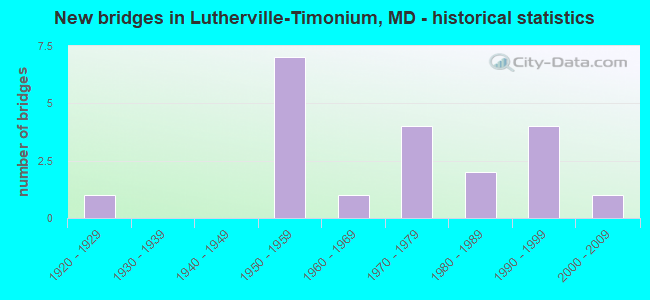
- New bridges - historical statistics
- 11920-1929
- 71950-1959
- 11960-1969
- 41970-1979
- 21980-1989
- 41990-1999
- 12000-2009

- Reconstructed bridges - Historical Statistics
- 11950-1959
- 01960-1969
- 01970-1979
- 11980-1989
- 01990-1999
- 12000-2009


- Bridge Condition - Deck
- 50.0%Good
- 50.0%Satisfactory

- Bridge Condition - Superstructure
- 50.0%Good
- 33.3%Satisfactory
- 16.7%Fair

- Bridge Condition - Substructure
- 16.7%Very good
- 16.7%Good
- 66.7%Satisfactory

- Bridge Condition - Channel
- 20.0%Good
- 60.0%Satisfactory
- 20.0%Fair

- Bridge Condition - Culverts
- 44.4%Good
- 33.3%Satisfactory
- 22.2%Fair
Find on map >> Show street view
Structure Number: 10000003007601, Location: 1.20 MI W OF MD 45 (Lat: 0.000108, Lng: -0.000019), Route carried "on" structure: State highway 131, Year Built: 1973, Status: Open, Structure Length: 8.41m (27.59ft), Average Daily Traffic: 11,441 (year 2009), Truck Traffic: 8%, Average Future Daily Traffic: 13,895 (year 2026), Design Load: HS 20, Features Intersected: IS 83
Minimum Vertical Clearance: 30+ m (98+ ft), Kilometerpoint: 2.993, Lanes on structure: 4, Lanes under structure: 6, Owner: State Highway Agency, Approaching Roadway Width: 15.9m (52.2ft), Skew: 1 degrees, Material/Design: Steel continuous, Design/Construction: Stringer/Multi-beam, Number Of Spans In Main Unit: 2, Number Of Approach Spans: 2, Length of Maximum Span: 30.2m (99.1ft), Curb or Sidewalk Widths: Left: 1.6m (5.2ft), Right: 1.6m (5.2ft), Curb-To-Curb Width: 15.9m (52.2ft), Out-to-Out Width: 19.6m (64.3ft)
Condition: Deck: Satisfactory, Superstructure: Satisfactory, Substructure: Satisfactory, Inventory Rating: 57.6 metric tons, Method Used To Determine Inventory Rating: Load Factor (LF), Structural Evaluation: Equal to present minimum criteria, Deck Geometry: Meets minimum limits, Underclear: Somewhat better than minimum adequacy, Approach Roadway Alignment: Equal to present desirable criteria, Designated Inspection Frequency: Every 24 months, Inspection Date: Febuary 2021, Deck Structure Type: Concrete Cast-file-Place, Wearing Surface/Protective System: Wearing Surface: Monolithic Concrete
Find on map >> Show street view
Structure Number: 10000003015101, Location: 0.79 MI S OF JOPPA ROAD (Lat: 0.000108, Lng: -0.000019), Route carried "on" structure: State highway 25, Year Built: 1996, Status: Open, Structure Length: 12.71m (41.70ft), Average Daily Traffic: 9,121 (year 2009), Truck Traffic: 8%, Average Future Daily Traffic: 11,393 (year 2026), Design Load: HS 25 or greater, Features Intersected: IS 695
Minimum Vertical Clearance: 30+ m (98+ ft), Kilometerpoint: 4.537, Lanes on structure: 2, Lanes under structure: 9, Owner: State Highway Agency, Approaching Roadway Width: 13.4m (44.0ft), Skew: 5 degrees, Material/Design: Steel continuous, Design/Construction: Stringer/Multi-beam, Number Of Spans In Main Unit: 2, Length of Maximum Span: 62.5m (205.1ft), Curb-To-Curb Width: 9.1m (29.9ft), Out-to-Out Width: 10.4m (34.1ft)
Condition: Deck: Good, Superstructure: Good, Substructure: Very good, Operating Rating: 81.6 metric tons, Method Used To Determine Operating Rating: Load Factor (LF), Inventory Rating: 49.0 metric tons, Method Used To Determine Inventory Rating: Load Factor (LF), Structural Evaluation: Better than present minimum criteria, Deck Geometry: Meets minimum limits, Underclear: Equal to present minimum criteria, Approach Roadway Alignment: Equal to present desirable criteria, Designated Inspection Frequency: Every 24 months, Inspection Date: January 2022, Deck Structure Type: Concrete Cast-file-Place, Wearing Surface/Protective System: Wearing Surface: Monolithic Concrete, Deck Protection: Epoxy Coated Reinforcing
Find on map >> Show street view
Structure Number: 10000003016301, Location: 1.26 MI N OF MD 146 (Lat: 0.000108, Lng: -0.000019), Route carried "on" structure: County highway 3334, Year Built: 2001, Status: Open, Structure Length: 8.08m (26.51ft), Average Daily Traffic: 10,140 (year 2014), Truck Traffic: 5%, Average Future Daily Traffic: 11,690 (year 2034), Design Load: HS 25 or greater, Features Intersected: IS 695, Facility Carried by Structure: PROVIDENCE ROAD
Minimum Vertical Clearance: 30+ m (98+ ft), Kilometerpoint: 1.464, Lanes on structure: 2, Lanes under structure: 8, Owner: State Highway Agency, Approaching Roadway Width: 78.6m (257.9ft), Skew: 1 degrees, Material/Design: Steel continuous, Design/Construction: Stringer/Multi-beam, Number Of Spans In Main Unit: 2, Length of Maximum Span: 39.6m (129.9ft), Curb or Sidewalk Widths: Left: 1.6m (5.2ft), Right: 0.0m, Curb-To-Curb Width: 14.2m (46.6ft), Out-to-Out Width: 16.8m (55.1ft)
Condition: Deck: Good, Superstructure: Good, Substructure: Good, Inventory Rating: 56.7 metric tons, Method Used To Determine Inventory Rating: Load Factor (LF), Structural Evaluation: Better than present minimum criteria, Deck Geometry: Superior to present desirable criteria, Underclear: Equal to present minimum criteria, Approach Roadway Alignment: Equal to present desirable criteria, Designated Inspection Frequency: Every 24 months, Inspection Date: June 2020, Deck Structure Type: Concrete Cast-file-Place, Wearing Surface/Protective System: Wearing Surface: Integral Concrete, Deck Protection: Epoxy Coated Reinforcing
Find on map >> Show street view
Structure Number: 10000003020301, Location: 0.22 MILE SOUTH OF MD 131 (Lat: 39.421681, Lng: -76.638972), Route carried "on" structure: Ramp Interstate 83, Year Built: 1973, Year Reconstructed: 1987, Status: Open, Structure Length: 43.37m (142.29ft), Average Daily Traffic: 37,400 (year 2008), Truck Traffic: 13%, Average Future Daily Traffic: 45,650 (year 2028), Design Load: HS 20, Features Intersected: IS 695, MTA LIGHT RAIL
Minimum Vertical Clearance: 30+ m (98+ ft), Kilometerpoint: 0.386, Lanes on structure: 2, Lanes under structure: 7, Base Highway Network: Yes, Owner: State Highway Agency, Approaching Roadway Width: 11.6m (38.1ft), Skew: 9 degrees, Material/Design: Steel, Design/Construction: Box Beam or Girders - Multiple, Number Of Spans In Main Unit: 12, Length of Maximum Span: 45.4m (149.0ft), Curb-To-Curb Width: 12.0m (39.4ft), Out-to-Out Width: 13.0m (42.7ft)
Condition: Deck: Satisfactory, Superstructure: Satisfactory, Substructure: Satisfactory, Operating Rating: 60.8 metric tons, Method Used To Determine Operating Rating: Load Factor (LF), Inventory Rating: 36.3 metric tons, Method Used To Determine Inventory Rating: Load Factor (LF), Structural Evaluation: Equal to present minimum criteria, Deck Geometry: Superior to present desirable criteria, Underclear: Somewhat better than minimum adequacy, Approach Roadway Alignment: Equal to present desirable criteria, Length Of Structure Improvement: 43.37m (142.29ft), Designated Inspection Frequency: Every 12 months, Critical Feature Inspection Frequency: Every 12 months, Inspection Date: April 2021, Critical Feature Inspection Date: April 2021, Bridge Improvement Cost: $3,646,000, Roadway Improvement Cost: $365,000, Total Project Cost: $4,011,000, Deck Structure Type: Concrete Cast-file-Place, Wearing Surface/Protective System: Wearing Surface: Monolithic Concrete
Find on map >> Show street view
Structure Number: 10000003036203, Location: 0.71 MI N OF CHURCH LANE (Lat: 0.000108, Lng: -0.000019), Route carried "on" structure: State highway 45, Year Built: 1989, Status: Open, Structure Length: 0.74m (2.43ft), Average Daily Traffic: 27,510 (year 2009), Truck Traffic: 8%, Average Future Daily Traffic: 31,077 (year 2026), Design Load: HS 20, Features Intersected: BRANCH OF BEAVERDAM RUN
Minimum Vertical Clearance: 30+ m (98+ ft), Kilometerpoint: 12.068, Lanes on structure: 4, Base Highway Network: Yes, Owner: State Highway Agency, Approaching Roadway Width: 17.7m (58.1ft), Material/Design: Steel, Design/Construction: Culvert, Length of Maximum Span: 3.4m (11.2ft), Curb or Sidewalk Widths: Left: 3.0m (9.8ft), Right: 3.5m (11.5ft)
Condition: Channel: Satisfactory, Culverts: Good, Inventory Rating: 55.3 metric tons, Method Used To Determine Inventory Rating: Load Factor (LF), Structural Evaluation: Better than present minimum criteria, Waterway Adequacy: Better than present minimum criteria, Approach Roadway Alignment: Equal to present desirable criteria, Designated Inspection Frequency: Every 24 months, Inspection Date: July 2021, Wearing Surface/Protective System: Wearing Surface: Bituminous
Find on map >> Show street view
Structure Number: 200000B-008601, Location: 0.6 MI N OF JOPPA RD (Lat: 39.417228, Lng: -76.647553), Route carried "on" structure: County highway 1117, Year Built: 1923, Year Reconstructed: 1963, Status: Posted for load, Structure Length: 1.10m (3.61ft), Average Daily Traffic: 8,085 (year 2021), Truck Traffic: 5%, Average Future Daily Traffic: 9,886 (year 2041), Features Intersected: ROLAND RUN, Facility Carried by Structure: THORNTON ROAD
Minimum Vertical Clearance: 30+ m (98+ ft), Kilometerpoint: 0.869, Lanes on structure: 2, Owner: County Highway Agency, Approaching Roadway Width: 12.8m (42.0ft), Skew: 4 degrees, Material/Design: Concrete, Design/Construction: Tee Beam, Number Of Spans In Main Unit: 1, Length of Maximum Span: 9.4m (30.8ft), Curb or Sidewalk Widths: Left: 1.2m (3.9ft), Right: 1.3m (4.3ft), Curb-To-Curb Width: 12.7m (41.7ft), Out-to-Out Width: 16.2m (53.1ft)
Condition: Deck: Satisfactory, Superstructure: Fair, Substructure: Satisfactory, Channel: Satisfactory, Operating Rating: 52.2 metric tons, Method Used To Determine Operating Rating: Load Factor (LF), Inventory Rating: 31.3 metric tons, Method Used To Determine Inventory Rating: Load Factor (LF), Structural Evaluation: Somewhat better than minimum adequacy, Deck Geometry: Somewhat better than minimum adequacy, Waterway Adequacy: Better than present minimum criteria, Approach Roadway Alignment: Equal to present desirable criteria, Designated Inspection Frequency: Every 24 months, Inspection Date: August 2021, Deck Structure Type: Concrete Cast-file-Place, Wearing Surface/Protective System: Wearing Surface: Bituminous
Find on map >> Show street view
Structure Number: 200000B-008801, Location: 0.4 MI W OF YORK RD (Lat: 39.455419, Lng: -76.639094), Route carried "on" structure: County highway 773, Year Built: 1961, Year Reconstructed: 2006, Status: Open, Structure Length: 4.93m (16.17ft), Average Daily Traffic: 38,963 (year 2020), Truck Traffic: 5%, Average Future Daily Traffic: 47,355 (year 2040), Design Load: HS 25 or greater, Features Intersected: MTA LIGHT RAIL, Facility Carried by Structure: PADONIA ROAD
Minimum Vertical Clearance: 30+ m (98+ ft), Kilometerpoint: 5.020, Lanes on structure: 6, Owner: County Highway Agency, Approaching Roadway Width: 21.3m (69.9ft), Skew: 23 degrees, Material/Design: Steel, Design/Construction: Stringer/Multi-beam, Number Of Spans In Main Unit: 3, Length of Maximum Span: 17.4m (57.1ft), Curb or Sidewalk Widths: Left: 3.1m (10.2ft), Right: 3.1m (10.2ft), Curb-To-Curb Width: 21.9m (71.9ft), Out-to-Out Width: 27.1m (88.9ft)
Condition: Deck: Good, Superstructure: Good, Substructure: Satisfactory, Operating Rating: 88.0 metric tons, Method Used To Determine Operating Rating: Load Factor (LF), Inventory Rating: 52.6 metric tons, Method Used To Determine Inventory Rating: Load Factor (LF), Structural Evaluation: Equal to present minimum criteria, Deck Geometry: High priority of corrective action, Underclear: Better than present minimum criteria, Approach Roadway Alignment: Equal to present desirable criteria, Designated Inspection Frequency: Every 24 months, Inspection Date: March 2020, Deck Structure Type: Concrete Cast-file-Place, Wearing Surface/Protective System: Wearing Surface: Monolithic Concrete, Membrane: Epoxy, Deck Protection: Epoxy Coated Reinforcing
Find on map >> Show street view
Structure Number: 200000B-030402, Location: 0.88 MI E OF MD 45 (Lat: 39.440856, Lng: -76.609983), Route carried "on" structure: County highway 917, Year Built: 1959, Status: Open, Structure Length: 0.88m (2.89ft), Average Daily Traffic: 1,068 (year 2017), Truck Traffic: 10%, Average Future Daily Traffic: 1,350 (year 2041), Design Load: HS 20, Features Intersected: SPRING BRANCH, Facility Carried by Structure: CINDER ROAD
Minimum Vertical Clearance: 30+ m (98+ ft), Kilometerpoint: 1.416, Lanes on structure: 3, Owner: County Highway Agency, Approaching Roadway Width: 12.8m (42.0ft), Skew: 5 degrees, Material/Design: Concrete, Design/Construction: Culvert, Number Of Spans In Main Unit: 1, Length of Maximum Span: 8.8m (28.9ft)
Condition: Channel: Fair, Culverts: Satisfactory, Operating Rating: 55.3 metric tons, Method Used To Determine Operating Rating: Load Factor (LF), Inventory Rating: 32.7 metric tons, Method Used To Determine Inventory Rating: Load Factor (LF), Structural Evaluation: Equal to present minimum criteria, Waterway Adequacy: Better than present minimum criteria, Approach Roadway Alignment: Equal to present desirable criteria, Designated Inspection Frequency: Every 24 months, Inspection Date: July 2021
Find on map >> Show street view
Structure Number: 200000B-030602, Location: 0.30 MI E OF MD 45 (Lat: 39.417250, Lng: -76.608569), Route carried "on" structure: County highway 1012, Year Built: 1955, Status: Posted for load, Structure Length: 0.61m (2.00ft), Average Daily Traffic: 715 (year 2021), Truck Traffic: 5%, Average Future Daily Traffic: 1,530 (year 2040), Design Load: HS 20, Features Intersected: LONG QUARTER BRANCH, Facility Carried by Structure: RIDGEFIELD ROAD
Minimum Vertical Clearance: 30+ m (98+ ft), Kilometerpoint: 0.483, Lanes on structure: 2, Owner: County Highway Agency, Approaching Roadway Width: 9.1m (29.9ft), Material/Design: Concrete, Design/Construction: Culvert, Number Of Spans In Main Unit: 1, Length of Maximum Span: 6.1m (20.0ft), Curb or Sidewalk Widths: Left: 1.2m (3.9ft), Right: 1.8m (5.9ft), Curb-To-Curb Width: 9.1m (29.9ft), Out-to-Out Width: 15.9m (52.2ft)
Condition: Channel: Satisfactory, Culverts: Satisfactory, Operating Rating: 41.7 metric tons, Method Used To Determine Operating Rating: Field evaluation and documented engineering judgment, Inventory Rating: 24.9 metric tons, Method Used To Determine Inventory Rating: Field evaluation and documented engineering judgment, Structural Evaluation: Equal to present minimum criteria, Deck Geometry: Equal to present minimum criteria, Waterway Adequacy: Better than present minimum criteria, Approach Roadway Alignment: Equal to present minimum criteria, Designated Inspection Frequency: Every 24 months, Inspection Date: July 2021, Deck Structure Type: Concrete Cast-file-Place, Wearing Surface/Protective System: Wearing Surface: Bituminous
Find on map >> Show street view
Structure Number: 200000B-031502, Location: 0.08 MI W OF MD 146 (Lat: 39.424944, Lng: -76.598417), Route carried "on" structure: County highway 995, Year Built: 1953, Status: Open, Structure Length: 0.85m (2.79ft), Average Daily Traffic: 11,432 (year 2021), Truck Traffic: 5%, Average Future Daily Traffic: 18,732 (year 2041), Features Intersected: LONG QUARTER BRANCH, Facility Carried by Structure: SEMINARY AVENUE
Minimum Vertical Clearance: 30+ m (98+ ft), Kilometerpoint: 1.706, Lanes on structure: 2, Owner: County Highway Agency, Approaching Roadway Width: 11.6m (38.1ft), Skew: 3 degrees, Material/Design: Concrete, Design/Construction: Culvert, Number Of Spans In Main Unit: 2, Length of Maximum Span: 3.4m (11.2ft)
Condition: Channel: Satisfactory, Culverts: Fair, Inventory Rating: 79.4 metric tons, Method Used To Determine Inventory Rating: Load Factor (LF), Structural Evaluation: Somewhat better than minimum adequacy, Waterway Adequacy: Equal to present minimum criteria, Approach Roadway Alignment: Equal to present desirable criteria, Designated Inspection Frequency: Every 24 months, Inspection Date: April 2021
Find on map >> Show street view
Structure Number: 200000B-034502, Location: 0.5 MI S OF TIMONIUM RD (Lat: 39.439444, Lng: -76.605669), Route carried "on" structure: County highway 811, Year Built: 1973, Status: Open, Structure Length: 0.82m (2.69ft), Average Daily Traffic: 13,145 (year 2021), Truck Traffic: 5%, Average Future Daily Traffic: 19,150 (year 2040), Design Load: HS 20, Features Intersected: SPRING BRANCH, Facility Carried by Structure: POT SPRING ROAD
Minimum Vertical Clearance: 30+ m (98+ ft), Kilometerpoint: 1.866, Lanes on structure: 2, Owner: County Highway Agency, Approaching Roadway Width: 12.8m (42.0ft), Material/Design: Concrete, Design/Construction: Culvert, Length of Maximum Span: 4.0m (13.1ft), Curb or Sidewalk Widths: Left: 2.5m (8.2ft), Right: 2.4m (7.9ft)
Condition: Channel: Good, Culverts: Satisfactory, Operating Rating: 46.3 metric tons, Method Used To Determine Operating Rating: Load Factor (LF), Inventory Rating: 27.7 metric tons, Method Used To Determine Inventory Rating: Load Factor (LF), Structural Evaluation: Equal to present minimum criteria, Waterway Adequacy: Better than present minimum criteria, Approach Roadway Alignment: Equal to present desirable criteria, Designated Inspection Frequency: Every 24 months, Inspection Date: August 2021
Find on map >> Show street view
Structure Number: 200000B-035002, Location: 0.62 MI N OF MD 146 (Lat: 39.421100, Lng: -76.607181), Route carried "on" structure: County highway 958, Year Built: 1959, Status: Open, Structure Length: 0.70m (2.30ft), Average Daily Traffic: 10,087 (year 2021), Truck Traffic: 5%, Average Future Daily Traffic: 16,528 (year 2041), Design Load: H 20, Features Intersected: LONG QUARTER BRANCH, Facility Carried by Structure: CHARMUTH ROAD
Minimum Vertical Clearance: 30+ m (98+ ft), Kilometerpoint: 0.998, Lanes on structure: 2, Owner: County Highway Agency, Approaching Roadway Width: 11.0m (36.1ft), Skew: 2 degrees, Material/Design: Concrete, Design/Construction: Culvert, Length of Maximum Span: 3.4m (11.2ft), Curb or Sidewalk Widths: Left: 1.2m (3.9ft), Right: 1.2m (3.9ft)
Condition: Channel: Satisfactory, Culverts: Fair, Inventory Rating: 56.2 metric tons, Method Used To Determine Inventory Rating: Load Factor (LF), Structural Evaluation: Somewhat better than minimum adequacy, Waterway Adequacy: Better than present minimum criteria, Approach Roadway Alignment: Equal to present desirable criteria, Designated Inspection Frequency: Every 24 months, Inspection Date: April 2021
Find on map >> Show street view
Structure Number: 200000B-040702, Location: 0.2 MI N. OF GIRDWOOD RD (Lat: 39.455186, Lng: -76.604067), Route carried "on" structure: County highway 811, Year Built: 1980, Status: Open, Structure Length: 0.76m (2.49ft), Average Daily Traffic: 9,940 (year 2011), Truck Traffic: 5%, Average Future Daily Traffic: 14,000 (year 2031), Design Load: HS 20, Features Intersected: KELLY BRANCH, Facility Carried by Structure: POT SPRING ROAD
Minimum Vertical Clearance: 30+ m (98+ ft), Kilometerpoint: 3.781, Lanes on structure: 2, Owner: County Highway Agency, Approaching Roadway Width: 7.3m (24.0ft), Skew: 1 degrees, Material/Design: Concrete, Design/Construction: Culvert, Number Of Spans In Main Unit: 2, Length of Maximum Span: 3.0m (9.8ft)
Condition: Channel: Fair, Culverts: Good, Operating Rating: 75.7 metric tons, Method Used To Determine Operating Rating: Load Factor (LF), Inventory Rating: 45.4 metric tons, Method Used To Determine Inventory Rating: Load Factor (LF), Structural Evaluation: Better than present minimum criteria, Waterway Adequacy: Equal to present minimum criteria, Approach Roadway Alignment: Equal to present desirable criteria, Designated Inspection Frequency: Every 24 months, Inspection Date: July 2021
Find on map >> Show street view
Structure Number: 200000B-045502, Location: 0.4 MI S OF TIMONIUM RD (Lat: 39.433278, Lng: -76.627844), Route carried "on" structure: County highway , Year Built: 1992, Status: Open, Structure Length: 0.82m (2.69ft), Average Daily Traffic: 5,000 (year 2016), Truck Traffic: 5%, Average Future Daily Traffic: 7,000 (year 2040), Design Load: HS 25 or greater, Features Intersected: TRIBUTARY TO ROLAND RUN, Facility Carried by Structure: BUSINESS PARK DR
Minimum Vertical Clearance: 30+ m (98+ ft), Kilometerpoint: 0.000, Lanes on structure: 2, Owner: County Highway Agency, Approaching Roadway Width: 9.1m (29.9ft), Material/Design: Concrete, Design/Construction: Culvert, Number Of Spans In Main Unit: 2, Length of Maximum Span: 3.0m (9.8ft), Curb or Sidewalk Widths: Left: 2.7m (8.9ft), Right: 1.5m (4.9ft), Curb-To-Curb Width: 9.1m (29.9ft), Out-to-Out Width: 13.4m (44.0ft)
Condition: Channel: Satisfactory, Culverts: Good, Inventory Rating: 62.1 metric tons, Method Used To Determine Inventory Rating: Load Factor (LF), Structural Evaluation: Better than present minimum criteria, Deck Geometry: Meets minimum limits, Waterway Adequacy: Somewhat better than minimum adequacy, Approach Roadway Alignment: Equal to present desirable criteria, Designated Inspection Frequency: Every 24 months, Inspection Date: August 2021, Deck Structure Type: Concrete Cast-file-Place, Wearing Surface/Protective System: Wearing Surface: Monolithic Concrete, Deck Protection: Epoxy Coated Reinforcing
Find on map >> Show street view
Structure Number: 200000B-045602, Location: 0.4 MI S OF TIMONIUM RD (Lat: 39.433114, Lng: -76.628383), Route carried "on" structure: County highway , Year Built: 1992, Status: Open, Structure Length: 1.46m (4.79ft), Average Daily Traffic: 5,000 (year 2016), Truck Traffic: 5%, Average Future Daily Traffic: 7,000 (year 2036), Design Load: HS 25 or greater, Features Intersected: TRIBUTARY TO ROLAND RUN, Facility Carried by Structure: BUSINESS PARK DRIV
Minimum Vertical Clearance: 30+ m (98+ ft), Kilometerpoint: 0.000, Lanes on structure: 2, Owner: County Highway Agency, Approaching Roadway Width: 9.1m (29.9ft), Material/Design: Concrete, Design/Construction: Culvert, Number Of Spans In Main Unit: 4, Length of Maximum Span: 3.0m (9.8ft), Curb or Sidewalk Widths: Left: 2.7m (8.9ft), Right: 1.5m (4.9ft), Curb-To-Curb Width: 9.1m (29.9ft), Out-to-Out Width: 13.4m (44.0ft)
Condition: Channel: Good, Culverts: Good, Inventory Rating: 66.2 metric tons, Method Used To Determine Inventory Rating: Load Factor (LF), Structural Evaluation: Better than present minimum criteria, Deck Geometry: Meets minimum limits, Waterway Adequacy: Better than present minimum criteria, Approach Roadway Alignment: Equal to present desirable criteria, Designated Inspection Frequency: Every 24 months, Inspection Date: August 2021, Deck Structure Type: Concrete Cast-file-Place, Wearing Surface/Protective System: Wearing Surface: Monolithic Concrete, Deck Protection: Epoxy Coated Reinforcing
Find on map >> Show street view
Structure Number: 100000030062011, Location: AT IS 83 (Lat: 39.454756, Lng: -76.646294), Route carried "under" structure: County highway 773, Year Built: 1950, Structure Length: 0. m, Average Daily Traffic: 38,152 (year 2009), Features Intersected: PADONIA ROAD, Facility Carried by Structure: IS 83 NBR
Minimum Vertical Clearance: 5.49m (18.01ft), Kilometerpoint: 4.360, Lanes on structure: 6, Lanes under structure: 2, Material/Design: Steel, Design/Construction: Stringer/Multi-beam, Length of Maximum Span: 16.5m (54.1ft)
Find on map >> Show street view
Structure Number: 100000030064011, Location: AT IS 83 (Lat: 39.437986, Lng: -76.633667), Route carried "under" structure: County highway 810, Year Built: 1954, Structure Length: 0. m, Average Daily Traffic: 25,480 (year 2005), Features Intersected: TIMONIUM ROAD, Facility Carried by Structure: IS 83 NBR
Minimum Vertical Clearance: 4.27m (14.01ft), Kilometerpoint: 3.829, Lanes on structure: 3, Lanes under structure: 2, Material/Design: Steel continuous, Design/Construction: Stringer/Multi-beam, Length of Maximum Span: 14.9m (48.9ft)
Find on map >> Show street view
Structure Number: 100000030064012, Location: AT IS 83 (Lat: 39.438228, Lng: -76.634086), Route carried "under" structure: County highway 810, Year Built: 1954, Structure Length: 0. m, Average Daily Traffic: 25,480 (year 2005), Features Intersected: TIMONIUM ROAD, Facility Carried by Structure: IS 83 SBR
Minimum Vertical Clearance: 4.27m (14.01ft), Kilometerpoint: 3.862, Lanes on structure: 3, Lanes under structure: 2, Material/Design: Steel continuous, Design/Construction: Stringer/Multi-beam, Length of Maximum Span: 14.9m (48.9ft)
Find on map >> Show street view
Structure Number: 10000003015101, Location: 0.36 M S OF BR NO 0315400 (Lat: 39.407158, Lng: -76.667942), Route carried "under" structure: Interstate 695, Year Built: 1996, Structure Length: 0. m, Average Daily Traffic: 176,700 (year 2009), Truck Traffic: 8%, Features Intersected: IS 695, Facility Carried by Structure: MD 25
Minimum Vertical Clearance: 5.49m (18.01ft), Kilometerpoint: 27.321, Lanes on structure: 2, Lanes under structure: 9, Material/Design: Steel continuous, Design/Construction: Stringer/Multi-beam, Length of Maximum Span: 62.5m (205.1ft)
Find on map >> Show street view
Structure Number: 10000003020301, Location: 0.5 MILE SOUTH OF MD 139 (Lat: 39.421681, Lng: -76.638972), Route carried "under" structure: Interstate 695, Year Built: 1973, Structure Length: 0. m, Average Daily Traffic: 179,082 (year 2009), Features Intersected: IS 695, MTA LIGHT RAIL, Facility Carried by Structure: IS 83 RAMP 'C'
Minimum Vertical Clearance: 5.49m (18.01ft), Kilometerpoint: 30.539, Lanes on structure: 2, Lanes under structure: 7, Material/Design: Steel, Design/Construction: Stringer/Multi-beam, Length of Maximum Span: 45.4m (149.0ft)