Bridge Statistics for Lynch, Kentucky (KY)
Condition, Traffic, Stress, Structural Evaluation, Project Costs
- National Bridge Inventory (NBI) Statistics
- 16Number of bridges
- 381ft / 116mTotal length
- $721,000Total costs
- 20,992Total average daily traffic
- 2,081Total average daily truck traffic
- National Bridge Inventory (NBI) Registered Bridges for Lynch
- No street view available for this location
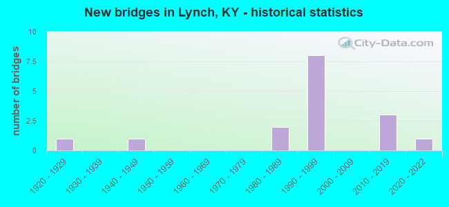
- New bridges - historical statistics
- 11920-1929
- 11940-1949
- 21980-1989
- 81990-1999
- 32010-2019
- 12020-2022


- Bridge Condition - Deck
- 7.1%Very good
- 42.9%Good
- 42.9%Satisfactory
- 7.1%Fair

- Bridge Condition - Superstructure
- 14.3%Very good
- 71.4%Good
- 14.3%Fair

- Bridge Condition - Substructure
- 7.1%Very good
- 64.3%Good
- 21.4%Satisfactory
- 7.1%Poor

- Bridge Condition - Channel
- 6.7%Excellent
- 20.0%Very good
- 60.0%Good
- 6.7%Satisfactory
- 6.7%Fair
Find on map >> Show street view
Structure Number: 48B00154N, Location: 6.2 MI. SE JCT US 119 (Lat: 36.956389, Lng: -82.888611), Route carried "on" structure: State highway 160, Year Built: 1988, Status: Open, Structure Length: 1.01m (3.31ft), Average Daily Traffic: 224 (year 2019), Truck Traffic: 14%, Average Future Daily Traffic: 185 (year 2039), Features Intersected: LOONEY CREEK
Minimum Vertical Clearance: 30+ m (98+ ft), Kilometerpoint: 8.703, Lanes on structure: 2, Base Highway Network: Yes, Owner: State Highway Agency, Approaching Roadway Width: 7.3m (24.0ft), Skew: 2 degrees, Material/Design: Concrete, Design/Construction: Culvert, Number Of Spans In Main Unit: 2, Length of Maximum Span: 4.6m (15.1ft)
Condition: Channel: Fair, Culverts: Good, Operating Rating: 54.4 metric tons, Method Used To Determine Operating Rating: Field evaluation and documented engineering judgment, Inventory Rating: 39.9 metric tons, Method Used To Determine Inventory Rating: Field evaluation and documented engineering judgment, Structural Evaluation: Better than present minimum criteria, Waterway Adequacy: Superior to present desirable criteria, Approach Roadway Alignment: Equal to present minimum criteria, Designated Inspection Frequency: Every 24 months, Inspection Date: July 2021
Find on map >> Show street view
Structure Number: 48B00155N, Location: 5.4 MI. S.E. JCT US 119 (Lat: 36.960833, Lng: -82.898889), Route carried "on" structure: State highway 160, Year Built: 1988, Status: Open, Structure Length: 2.07m (6.79ft), Average Daily Traffic: 224 (year 2019), Truck Traffic: 14%, Average Future Daily Traffic: 185 (year 2039), Design Load: HS 20, Features Intersected: LOONEY CREEK
Minimum Vertical Clearance: 30+ m (98+ ft), Kilometerpoint: 9.923, Lanes on structure: 2, Base Highway Network: Yes, Owner: State Highway Agency, Approaching Roadway Width: 7.3m (24.0ft), Skew: 4 degrees, Material/Design: Prestressed concrete, Design/Construction: Box Beam or Girders - Multiple, Number Of Spans In Main Unit: 1, Length of Maximum Span: 20.7m (67.9ft), Curb or Sidewalk Widths: Left: 2.0m (6.6ft), Right: 0.0m, Curb-To-Curb Width: 8.5m (27.9ft), Out-to-Out Width: 11.0m (36.1ft)
Condition: Deck: Satisfactory, Superstructure: Very good, Substructure: Satisfactory, Channel: Good, Operating Rating: 66.5 metric tons, Method Used To Determine Operating Rating: Load Factor (LF), Inventory Rating: 39.9 metric tons, Method Used To Determine Inventory Rating: Load Factor (LF), Structural Evaluation: Equal to present minimum criteria, Deck Geometry: Equal to present minimum criteria, Waterway Adequacy: Equal to present desirable criteria, Approach Roadway Alignment: Equal to present minimum criteria, Designated Inspection Frequency: Every 24 months, Inspection Date: July 2021, Deck Structure Type: Concrete Cast-file-Place, Wearing Surface/Protective System: Wearing Surface: Monolithic Concrete, Membrane: Epoxy, Deck Protection: Epoxy Coated Reinforcing
Find on map >> Show street view
Structure Number: 48B00160N, Location: .2 MI. S. LETCHER CO LNE (Lat: 36.999444, Lng: -82.915000), Route carried "on" structure: US 119, Year Built: 1992, Status: Open, Structure Length: 4.66m (15.29ft), Average Daily Traffic: 2,411 (year 2020), Truck Traffic: 13%, Average Future Daily Traffic: 2,266 (year 2040), Design Load: HS 25 or greater, Features Intersected: POOR FORK CUMBERLAND RIV
Minimum Vertical Clearance: 30+ m (98+ ft), Kilometerpoint: 62.874, Lanes on structure: 2, Base Highway Network: Yes, Owner: State Highway Agency, Approaching Roadway Width: 16.8m (55.1ft), Material/Design: Prestressed concrete continuous, Design/Construction: Stringer/Multi-beam, Number Of Spans In Main Unit: 3, Length of Maximum Span: 18.3m (60.0ft), Curb-To-Curb Width: 13.4m (44.0ft), Out-to-Out Width: 14.3m (46.9ft)
Condition: Deck: Satisfactory, Superstructure: Good, Substructure: Good, Channel: Good, Operating Rating: 79.3 metric tons, Method Used To Determine Operating Rating: Load Factor (LF), Inventory Rating: 47.6 metric tons, Method Used To Determine Inventory Rating: Load Factor (LF), Structural Evaluation: Better than present minimum criteria, Deck Geometry: Better than present minimum criteria, Waterway Adequacy: Superior to present desirable criteria, Approach Roadway Alignment: Equal to present desirable criteria, Designated Inspection Frequency: Every 24 months, Inspection Date: July 2021, Deck Structure Type: Concrete Cast-file-Place, Wearing Surface/Protective System: Wearing Surface: Monolithic Concrete, Deck Protection: Epoxy Coated Reinforcing
Find on map >> Show street view
Structure Number: 48B00161N, Location: .8 MI.S. LETCHER CO LINE (Lat: 36.996667, Lng: -82.925556), Route carried "on" structure: US 119, Year Built: 1992, Status: Open, Structure Length: 4.85m (15.91ft), Average Daily Traffic: 2,411 (year 2020), Truck Traffic: 13%, Average Future Daily Traffic: 2,266 (year 2040), Design Load: HS 25 or greater, Features Intersected: POOR FORK CUMBERLAND RIV
Minimum Vertical Clearance: 30+ m (98+ ft), Kilometerpoint: 61.865, Lanes on structure: 2, Base Highway Network: Yes, Owner: State Highway Agency, Approaching Roadway Width: 16.8m (55.1ft), Skew: 1 degrees, Material/Design: Prestressed concrete continuous, Design/Construction: Box Beam or Girders - Single/Spread, Number Of Spans In Main Unit: 3, Length of Maximum Span: 19.8m (65.0ft), Curb or Sidewalk Widths: Left: 0.5m (1.6ft), Right: 0.5m (1.6ft), Curb-To-Curb Width: 13.4m (44.0ft), Out-to-Out Width: 14.3m (46.9ft)
Condition: Deck: Good, Superstructure: Good, Substructure: Good, Channel: Good, Operating Rating: 96.9 metric tons, Method Used To Determine Operating Rating: Load Factor (LF), Inventory Rating: 58.2 metric tons, Method Used To Determine Inventory Rating: Load Factor (LF), Structural Evaluation: Better than present minimum criteria, Deck Geometry: Better than present minimum criteria, Waterway Adequacy: Superior to present desirable criteria, Approach Roadway Alignment: Equal to present desirable criteria, Designated Inspection Frequency: Every 24 months, Inspection Date: July 2021, Deck Structure Type: Concrete Cast-file-Place, Wearing Surface/Protective System: Wearing Surface: Monolithic Concrete, Deck Protection: Epoxy Coated Reinforcing
Find on map >> Show street view
Structure Number: 48B00163N, Location: 1.6 MI.S. LETCHER CO LINE (Lat: 36.991389, Lng: -82.940833), Route carried "on" structure: US 119, Year Built: 1990, Status: Open, Structure Length: 6.89m (22.60ft), Average Daily Traffic: 2,411 (year 2020), Truck Traffic: 13%, Average Future Daily Traffic: 2,266 (year 2040), Design Load: HS 25 or greater, Features Intersected: POOR FORK CUMBERLAND RIV
Minimum Vertical Clearance: 30+ m (98+ ft), Kilometerpoint: 60.386, Lanes on structure: 2, Base Highway Network: Yes, Owner: State Highway Agency, Approaching Roadway Width: 15.8m (51.8ft), Skew: 4 degrees, Material/Design: Prestressed concrete continuous, Design/Construction: Stringer/Multi-beam, Number Of Spans In Main Unit: 3, Length of Maximum Span: 22.9m (75.1ft), Curb-To-Curb Width: 13.4m (44.0ft), Out-to-Out Width: 14.3m (46.9ft)
Condition: Deck: Satisfactory, Superstructure: Good, Substructure: Good, Channel: Good, Operating Rating: 65.1 metric tons, Method Used To Determine Operating Rating: Load Factor (LF), Inventory Rating: 39.1 metric tons, Method Used To Determine Inventory Rating: Load Factor (LF), Structural Evaluation: Better than present minimum criteria, Deck Geometry: Better than present minimum criteria, Waterway Adequacy: Superior to present desirable criteria, Approach Roadway Alignment: Equal to present desirable criteria, Designated Inspection Frequency: Every 24 months, Inspection Date: July 2021, Deck Structure Type: Concrete Cast-file-Place, Wearing Surface/Protective System: Wearing Surface: Monolithic Concrete, Deck Protection: Epoxy Coated Reinforcing
Find on map >> Show street view
Structure Number: 48B00164N, Location: 1.4 MI.S. LETCHER CO LINE (Lat: 36.993333, Lng: -82.936389), Route carried "on" structure: US 119, Year Built: 1990, Status: Open, Structure Length: 4.72m (15.49ft), Average Daily Traffic: 2,411 (year 2020), Truck Traffic: 13%, Average Future Daily Traffic: 2,266 (year 2040), Design Load: HS 25 or greater, Features Intersected: POOR FORK CUMBERLAND RIV
Minimum Vertical Clearance: 30+ m (98+ ft), Kilometerpoint: 60.836, Lanes on structure: 2, Base Highway Network: Yes, Owner: State Highway Agency, Approaching Roadway Width: 14.6m (47.9ft), Skew: 1 degrees, Material/Design: Prestressed concrete continuous, Design/Construction: Stringer/Multi-beam, Number Of Spans In Main Unit: 3, Length of Maximum Span: 15.2m (49.9ft), Curb-To-Curb Width: 13.4m (44.0ft), Out-to-Out Width: 14.3m (46.9ft)
Condition: Deck: Satisfactory, Superstructure: Good, Substructure: Good, Channel: Satisfactory, Operating Rating: 74.4 metric tons, Method Used To Determine Operating Rating: Load Factor (LF), Inventory Rating: 44.6 metric tons, Method Used To Determine Inventory Rating: Load Factor (LF), Structural Evaluation: Better than present minimum criteria, Deck Geometry: Better than present minimum criteria, Waterway Adequacy: Superior to present desirable criteria, Approach Roadway Alignment: Equal to present desirable criteria, Designated Inspection Frequency: Every 24 months, Inspection Date: July 2021, Deck Structure Type: Concrete Cast-file-Place, Wearing Surface/Protective System: Wearing Surface: Monolithic Concrete, Deck Protection: Epoxy Coated Reinforcing
Find on map >> Show street view
Structure Number: 48B00165N, Location: 1.1 MI.S. LETCHER CO LINE (Lat: 36.995556, Lng: -82.931944), Route carried "on" structure: US 119, Year Built: 1990, Status: Open, Structure Length: 6.61m (21.69ft), Average Daily Traffic: 2,411 (year 2020), Truck Traffic: 13%, Average Future Daily Traffic: 2,266 (year 2040), Design Load: HS 20, Features Intersected: POOR FORK CUMBERLAND RIV
Minimum Vertical Clearance: 30+ m (98+ ft), Kilometerpoint: 61.300, Lanes on structure: 2, Base Highway Network: Yes, Owner: State Highway Agency, Approaching Roadway Width: 14.6m (47.9ft), Skew: 3 degrees, Material/Design: Prestressed concrete continuous, Design/Construction: Stringer/Multi-beam, Number Of Spans In Main Unit: 3, Length of Maximum Span: 24.4m (80.1ft), Curb-To-Curb Width: 13.4m (44.0ft), Out-to-Out Width: 14.3m (46.9ft)
Condition: Deck: Good, Superstructure: Good, Substructure: Good, Channel: Good, Operating Rating: 73.4 metric tons, Method Used To Determine Operating Rating: Load Factor (LF), Inventory Rating: 44.1 metric tons, Method Used To Determine Inventory Rating: Load Factor (LF), Structural Evaluation: Better than present minimum criteria, Deck Geometry: Better than present minimum criteria, Waterway Adequacy: Superior to present desirable criteria, Approach Roadway Alignment: Equal to present desirable criteria, Designated Inspection Frequency: Every 24 months, Inspection Date: July 2021, Deck Structure Type: Concrete Cast-file-Place, Wearing Surface/Protective System: Wearing Surface: Monolithic Concrete, Deck Protection: Epoxy Coated Reinforcing
Find on map >> Show street view
Structure Number: 48C00008N, Location: 500' SW OF JCT US 119 (Lat: 36.993333, Lng: -82.926944), Route carried "on" structure: County highway 1020, Year Built: 1940, Status: Posted for load, Structure Length: 1.68m (5.51ft), Average Daily Traffic: 20 (year 2006), Average Future Daily Traffic: 2,026 (year 2026), Features Intersected: POOR FK CUMBERLAND RVR, Facility Carried by Structure: RASNICK RD
Minimum Vertical Clearance: 30+ m (98+ ft), Kilometerpoint: 0.027, Lanes on structure: 1, Owner: County Highway Agency, Approaching Roadway Width: 3.7m (12.1ft), Material/Design: Steel, Design/Construction: Stringer/Multi-beam, Number Of Spans In Main Unit: 2, Length of Maximum Span: 10.7m (35.1ft), Curb-To-Curb Width: 3.4m (11.2ft), Out-to-Out Width: 3.7m (12.1ft)
Condition: Deck: Satisfactory, Superstructure: Fair, Substructure: Poor, Channel: Good, Operating Rating: 36.7 metric tons, Method Used To Determine Operating Rating: Load Factor (LF), Inventory Rating: 22.0 metric tons, Method Used To Determine Inventory Rating: Load Factor (LF), Structural Evaluation: Meets minimum limits, Deck Geometry: High priority of corrective action, Waterway Adequacy: Equal to present desirable criteria, Approach Roadway Alignment: Meets minimum limits, Bridge Posting: Required (Relationship of Operating Rating to Maximum Legal Load: > 39.9% below), Length Of Structure Improvement: 0.16m (0.52ft), Designated Inspection Frequency: Every 12 months, Inspection Date: September 2021, Bridge Improvement Cost: $72,000, Total Project Cost: $72,000, Deck Structure Type: Concrete Precast Panels
Find on map >> Show street view
Structure Number: 48C00195N, Location: .80 MI W OF LETCHER CO LN (Lat: 36.994722, Lng: -82.925278), Route carried "on" structure: Business County highway 1020, Year Built: 1928, Status: Posted for load, Structure Length: 4.85m (15.91ft), Average Daily Traffic: 3,342 (year 2006), Average Future Daily Traffic: 2,026 (year 2026), Design Load: H 15, Features Intersected: POOR FK CUMBERLAND RVR, Facility Carried by Structure: OLD HWY 119
Minimum Vertical Clearance: 30+ m (98+ ft), Kilometerpoint: 0.233, Lanes on structure: 2, Owner: County Highway Agency, Approaching Roadway Width: 6.1m (20.0ft), Skew: 4 degrees, Material/Design: Concrete, Design/Construction: Tee Beam, Number Of Spans In Main Unit: 3, Length of Maximum Span: 15.2m (49.9ft), Curb or Sidewalk Widths: Left: 0.2m (0.7ft), Right: 0.2m (0.7ft), Curb-To-Curb Width: 5.8m (19.0ft), Out-to-Out Width: 7.0m (23.0ft)
Condition: Deck: Fair, Superstructure: Fair, Substructure: Satisfactory, Channel: Good, Operating Rating: 32.5 metric tons, Method Used To Determine Operating Rating: Load Factor (LF), Inventory Rating: 19.5 metric tons, Method Used To Determine Inventory Rating: Load Factor (LF), Structural Evaluation: Somewhat better than minimum adequacy, Deck Geometry: High priority of replacement, Waterway Adequacy: Superior to present desirable criteria, Approach Roadway Alignment: Equal to present desirable criteria, Bridge Posting: Required (Relationship of Operating Rating to Maximum Legal Load: > 39.9% below), Length Of Structure Improvement: 0.48m (1.57ft), Designated Inspection Frequency: Every 24 months, Inspection Date: September 2021, Bridge Improvement Cost: $501,000, Total Project Cost: $500,000, Deck Structure Type: Concrete Cast-file-Place, Wearing Surface/Protective System: Wearing Surface: Bituminous
Find on map >> Show street view
Structure Number: 67B00117N, Location: 0.65 MI S JCT US 119 (Lat: 36.996667, Lng: -82.897778), Route carried "on" structure: State highway 3403, Year Built: 1991, Status: Open, Structure Length: 1.04m (3.41ft), Average Daily Traffic: 115 (year 2020), Average Future Daily Traffic: 100 (year 2040), Design Load: HS 25 or greater, Features Intersected: LEWIS CREEK
Minimum Vertical Clearance: 30+ m (98+ ft), Kilometerpoint: 0.584, Lanes on structure: 2, Owner: State Highway Agency, Approaching Roadway Width: 4.0m (13.1ft), Skew: 4 degrees, Material/Design: Prestressed concrete, Design/Construction: Box Beam or Girders - Multiple, Number Of Spans In Main Unit: 1, Length of Maximum Span: 9.1m (29.9ft), Curb-To-Curb Width: 6.0m (19.7ft), Out-to-Out Width: 6.5m (21.3ft)
Condition: Deck: Good, Superstructure: Good, Substructure: Satisfactory, Channel: Very good, Operating Rating: 60.9 metric tons, Method Used To Determine Operating Rating: Load Factor (LF), Inventory Rating: 36.6 metric tons, Method Used To Determine Inventory Rating: Load Factor (LF), Structural Evaluation: Equal to present minimum criteria, Deck Geometry: High priority of corrective action, Waterway Adequacy: Better than present minimum criteria, Approach Roadway Alignment: High priority of corrective action, Designated Inspection Frequency: Every 24 months, Inspection Date: May 2021, Deck Structure Type: Concrete Precast Panels
Find on map >> Show street view
Structure Number: 67B00125N, Location: .01 MI SOU JCT US 119 (Lat: 37.005000, Lng: -82.900278), Route carried "on" structure: State highway 3403, Year Built: 1992, Status: Open, Structure Length: 4.05m (13.29ft), Average Daily Traffic: 115 (year 2020), Average Future Daily Traffic: 100 (year 2040), Design Load: HS 25 or greater, Features Intersected: POOR FK-CUMBERLAND RIVER
Minimum Vertical Clearance: 30+ m (98+ ft), Kilometerpoint: 1.601, Lanes on structure: 2, Owner: State Highway Agency, Approaching Roadway Width: 7.3m (24.0ft), Material/Design: Prestressed concrete, Design/Construction: Stringer/Multi-beam, Number Of Spans In Main Unit: 3, Length of Maximum Span: 14.3m (46.9ft), Curb-To-Curb Width: 7.4m (24.3ft), Out-to-Out Width: 8.4m (27.6ft)
Condition: Deck: Good, Superstructure: Good, Substructure: Good, Channel: Good, Operating Rating: 78.3 metric tons, Method Used To Determine Operating Rating: Load Factor (LF), Inventory Rating: 47.0 metric tons, Method Used To Determine Inventory Rating: Load Factor (LF), Structural Evaluation: Better than present minimum criteria, Deck Geometry: Somewhat better than minimum adequacy, Waterway Adequacy: Equal to present desirable criteria, Approach Roadway Alignment: Equal to present desirable criteria, Designated Inspection Frequency: Every 24 months, Inspection Date: May 2021, Deck Structure Type: Concrete Cast-file-Place, Wearing Surface/Protective System: Wearing Surface: Monolithic Concrete, Deck Protection: Epoxy Coated Reinforcing
Find on map >> Show street view
Structure Number: 67B00136N, Location: 1.6 MI NE of Harlan Co (Lat: 37.013725, Lng: -82.890772), Route carried "on" structure: US 119, Year Built: 2015, Status: Open, Structure Length: 11.83m (38.81ft), Average Daily Traffic: 2,074 (year 2018), Truck Traffic: 13%, Average Future Daily Traffic: 1,949 (year 2038), Design Load: HS 25 or greater, Features Intersected: Poor Frk of Cumberland
Minimum Vertical Clearance: 30+ m (98+ ft), Kilometerpoint: 2.615, Lanes on structure: 2, Base Highway Network: Yes, Owner: State Highway Agency, Approaching Roadway Width: 14.6m (47.9ft), Skew: 1 degrees, Material/Design: Prestressed concrete continuous, Design/Construction: Stringer/Multi-beam, Number Of Spans In Main Unit: 5, Length of Maximum Span: 28.0m (91.9ft), Curb-To-Curb Width: 14.6m (47.9ft), Out-to-Out Width: 15.8m (51.8ft)
Condition: Deck: Good, Superstructure: Good, Substructure: Good, Channel: Very good, Operating Rating: 83.9 metric tons, Method Used To Determine Operating Rating: Load Factor (LF), Inventory Rating: 50.3 metric tons, Method Used To Determine Inventory Rating: Load Factor (LF), Structural Evaluation: Better than present minimum criteria, Deck Geometry: Superior to present desirable criteria, Waterway Adequacy: Equal to present desirable criteria, Approach Roadway Alignment: Equal to present desirable criteria, Designated Inspection Frequency: Every 24 months, Inspection Date: May 2020, Deck Structure Type: Concrete Cast-file-Place, Wearing Surface/Protective System: Wearing Surface: Monolithic Concrete, Deck Protection: Epoxy Coated Reinforcing
Find on map >> Show street view
Structure Number: 67B00137N, Location: 2.15 MI NE of Harlan Co (Lat: 37.015556, Lng: -82.881111), Route carried "on" structure: US 119, Year Built: 2017, Status: Open, Structure Length: 57.62m (189.04ft), Average Daily Traffic: 1,543 (year 2014), Truck Traffic: 12%, Average Future Daily Traffic: 1,450 (year 2034), Design Load: HS 25 or greater, Features Intersected: KY-3404/P Fk Cumberland
Minimum Vertical Clearance: 30+ m (98+ ft), Kilometerpoint: 3.462, Lanes on structure: 2, Lanes under structure: 2, Base Highway Network: Yes, Owner: State Highway Agency, Approaching Roadway Width: 14.7m (48.2ft), Material/Design: Prestressed concrete continuous, Design/Construction: Stringer/Multi-beam, Number Of Spans In Main Unit: 14, Length of Maximum Span: 42.4m (139.1ft), Curb-To-Curb Width: 14.6m (47.9ft), Out-to-Out Width: 15.8m (51.8ft)
Condition: Deck: Good, Superstructure: Good, Substructure: Good, Channel: Excellent, Operating Rating: 60.9 metric tons, Method Used To Determine Operating Rating: Load and Resistance Factor Rating (LRFR) rating reported by rating factor(RF) method using HL-93 loadings, Inventory Rating: 47.0 metric tons, Method Used To Determine Inventory Rating: Load and Resistance Factor Rating (LRFR) rating reported by rating factor(RF) method using HL-93 loadings, Structural Evaluation: Better than present minimum criteria, Deck Geometry: Superior to present desirable criteria, Underclear: Equal to present minimum criteria, Waterway Adequacy: Equal to present minimum criteria, Approach Roadway Alignment: Equal to present minimum criteria, Designated Inspection Frequency: Every 24 months, Inspection Date: May 2020, Deck Structure Type: Concrete Cast-file-Place, Wearing Surface/Protective System: Wearing Surface: Monolithic Concrete, Deck Protection: Epoxy Coated Reinforcing
Find on map >> Show street view
Structure Number: 67B00144N, Location: 0.1 MI S of JCT KY 3619 (Lat: 37.015556, Lng: -82.883056), Route carried "on" structure: State highway 3404, Year Built: 2020, Status: Open, Structure Length: 2.53m (8.30ft), Average Daily Traffic: 526 (year 2018), Average Future Daily Traffic: 457 (year 2038), Design Load: Greater than HL93, Features Intersected: Poor Frk of Cumberland
Minimum Vertical Clearance: 30+ m (98+ ft), Kilometerpoint: 1.262, Lanes on structure: 2, Owner: State Highway Agency, Approaching Roadway Width: 4.3m (14.1ft), Material/Design: Prestressed concrete, Design/Construction: Stringer/Multi-beam, Number Of Spans In Main Unit: 1, Length of Maximum Span: 24.4m (80.1ft), Curb-To-Curb Width: 6.1m (20.0ft), Out-to-Out Width: 6.9m (22.6ft)
Condition: Deck: Very good, Superstructure: Very good, Substructure: Very good, Channel: Very good, Operating Rating: 66.7 metric tons, Method Used To Determine Operating Rating: Load and Resistance Factor Rating (LRFR) rating reported by rating factor(RF) method using HL-93 loadings, Inventory Rating: 51.5 metric tons, Method Used To Determine Inventory Rating: Load and Resistance Factor Rating (LRFR) rating reported by rating factor(RF) method using HL-93 loadings, Structural Evaluation: Equal to present desirable criteria, Deck Geometry: High priority of corrective action, Waterway Adequacy: Equal to present desirable criteria, Approach Roadway Alignment: Equal to present desirable criteria, Designated Inspection Frequency: Every 24 months, Inspection Date: September 2020, Deck Structure Type: Concrete Cast-file-Place, Wearing Surface/Protective System: Wearing Surface: Monolithic Concrete, Deck Protection: Epoxy Coated Reinforcing
Find on map >> Show street view
Structure Number: 67C00070N, Location: SW US 119@ HARLAN CO LINE (Lat: 37.001389, Lng: -82.908889), Route carried "on" structure: County highway 1289, Year Built: 1993, Status: Open, Structure Length: 1.71m (5.61ft), Average Daily Traffic: 228 (year 2019), Average Future Daily Traffic: 198 (year 2039), Design Load: HS 25 or greater, Features Intersected: POOR FORK-CUMBERLAND, Facility Carried by Structure: SKY VIEW BOTTOM
Minimum Vertical Clearance: 30+ m (98+ ft), Kilometerpoint: 0.134, Lanes on structure: 2, Owner: County Highway Agency, Approaching Roadway Width: 5.8m (19.0ft), Material/Design: Prestressed concrete, Design/Construction: Box Beam or Girders - Multiple, Number Of Spans In Main Unit: 1, Length of Maximum Span: 16.2m (53.1ft), Curb-To-Curb Width: 6.0m (19.7ft), Out-to-Out Width: 6.5m (21.3ft)
Condition: Deck: Satisfactory, Superstructure: Good, Substructure: Good, Channel: Good, Operating Rating: 61.2 metric tons, Method Used To Determine Operating Rating: Load Factor (LF), Inventory Rating: 36.7 metric tons, Method Used To Determine Inventory Rating: Load Factor (LF), Structural Evaluation: Better than present minimum criteria, Deck Geometry: High priority of corrective action, Waterway Adequacy: Equal to present desirable criteria, Approach Roadway Alignment: Equal to present desirable criteria, Length Of Structure Improvement: 0.17m (0.56ft), Designated Inspection Frequency: Every 24 months, Inspection Date: May 2021, Bridge Improvement Cost: $149,000, Total Project Cost: $149,000, Deck Structure Type: Concrete Precast Panels
Find on map >> Show street view
Structure Number: 67B00137N, Location: 2.15 MI NE of Harlan Co (Lat: 37.015556, Lng: -82.881111), Route carried "under" structure: State highway 3404, Year Built: 2017, Structure Length: 0. m, Average Daily Traffic: 526 (year 2018), Features Intersected: KY-3404/P Fk Cumberland, Facility Carried by Structure: US-119
Minimum Vertical Clearance: 12.19m (39.99ft), Kilometerpoint: 1.197, Lanes on structure: 2, Lanes under structure: 2, Material/Design: Prestressed concrete continuous, Design/Construction: Stringer/Multi-beam, Length of Maximum Span: 42.4m (139.1ft)