Bridge Statistics for Lynd, Minnesota (MN)
Condition, Traffic, Stress, Structural Evaluation, Project Costs
- National Bridge Inventory (NBI) Statistics
- 14Number of bridges
- 112ft / 34.0mTotal length
- $555,002,000Total costs
- 2,899Total average daily traffic
- 187Total average daily truck traffic
- 3,086Total future (year 2029) average daily traffic
- National Bridge Inventory (NBI) Registered Bridges for Lynd
- No street view available for this location
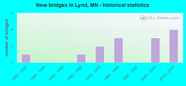
- New bridges - historical statistics
- 11930-1939
- 11960-1969
- 21970-1979
- 31980-1989
- 32000-2009
- 42010-2019

- Bridge Condition - Deck
- 30.0%Excellent
- 30.0%Very good
- 20.0%Good
- 10.0%Satisfactory
- 10.0%Fair

- Bridge Condition - Superstructure
- 30.0%Excellent
- 40.0%Very good
- 20.0%Good
- 10.0%Satisfactory

- Bridge Condition - Substructure
- 30.0%Excellent
- 30.0%Very good
- 10.0%Good
- 20.0%Satisfactory
- 10.0%Fair

- Bridge Condition - Channel
- 15.4%Very good
- 69.2%Good
- 15.4%Satisfactory

- Bridge Condition - Culverts
- 25.0%Excellent
- 25.0%Very good
- 50.0%Satisfactory
Find on map >> Show street view
Structure Number: 3711, Location: 7.0 MI W OF MARSHALL (Lat: 44.443364, Lng: -95.931647), Route carried "on" structure: State highway 19, Year Built: 1937, Status: Open, Structure Length: 1.00m (3.28ft), Average Daily Traffic: 1,440 (year 2019), Truck Traffic: 13%, Average Future Daily Traffic: 1,600 (year 2039), Design Load: H 15, Features Intersected: THREE MILE CREEK
Minimum Vertical Clearance: 30+ m (98+ ft), Kilometerpoint: 0.000, Lanes on structure: 2, Base Highway Network: Yes, Owner: State Highway Agency, Approaching Roadway Width: 9.1m (29.9ft), Material/Design: Concrete, Design/Construction: Culvert, Number Of Spans In Main Unit: 3, Length of Maximum Span: 3.0m (9.8ft)
Condition: Channel: Good, Culverts: Satisfactory, Operating Rating: 39.2 metric tons, Method Used To Determine Operating Rating: Assigned ratings based on Allowable Stress Design (ASD) reported in metric tons, Inventory Rating: 29.4 metric tons, Method Used To Determine Inventory Rating: Assigned ratings based on Allowable Stress Design (ASD) reported in metric tons, Structural Evaluation: Equal to present minimum criteria, Waterway Adequacy: Equal to present desirable criteria, Approach Roadway Alignment: Equal to present desirable criteria, Length Of Structure Improvement: 0.49m (1.61ft), Designated Inspection Frequency: Every 24 months, Inspection Date: October 2020, Bridge Improvement Cost: $188,000,000, Roadway Improvement Cost: $5,000,000, Total Project Cost: $78,000,000
Find on map >> Show street view
Structure Number: 42515, Location: 0.2 MI W OF JCT TH 23 (Lat: 44.414044, Lng: -95.860131), Route carried "on" structure: County highway 74, Year Built: 1969, Status: Posted for load, Structure Length: 3.17m (10.40ft), Average Daily Traffic: 190 (year 2010), Average Future Daily Traffic: 190 (year 2039), Design Load: H 20, Features Intersected: REDWOOD RIVER
Minimum Vertical Clearance: 30+ m (98+ ft), Kilometerpoint: 0.000, Lanes on structure: 2, Owner: County Highway Agency, Approaching Roadway Width: 9.1m (29.9ft), Material/Design: Wood or Timber, Design/Construction: Slab, Number Of Spans In Main Unit: 4, Length of Maximum Span: 8.0m (26.2ft), Curb-To-Curb Width: 8.0m (26.2ft), Out-to-Out Width: 8.4m (27.6ft)
Condition: Deck: Good, Superstructure: Good, Substructure: Satisfactory, Channel: Good, Operating Rating: 42.4 metric tons, Method Used To Determine Operating Rating: Allowable Stress (AS), Inventory Rating: 29.0 metric tons, Method Used To Determine Inventory Rating: Allowable Stress (AS), Structural Evaluation: Equal to present minimum criteria, Deck Geometry: Somewhat better than minimum adequacy, Waterway Adequacy: Equal to present desirable criteria, Approach Roadway Alignment: Equal to present desirable criteria, Bridge Posting: Required (Relationship of Operating Rating to Maximum Legal Load: 20.0 - 29.9% below), Designated Inspection Frequency: Every 24 months, Inspection Date: October 2021, Deck Structure Type: Wood or Timber, Wearing Surface/Protective System: Wearing Surface: Gravel
Find on map >> Show street view
Structure Number: 42526, Location: 1.7 MI SW OF JCT CSAH 5 (Lat: 44.375911, Lng: -95.918336), Route carried "on" structure: County highway 25, Year Built: 1975, Status: Posted for load, Structure Length: 2.56m (8.40ft), Average Daily Traffic: 180 (year 2014), Average Future Daily Traffic: 180 (year 2039), Design Load: HS 20, Features Intersected: REDWOOD RIVER
Minimum Vertical Clearance: 30+ m (98+ ft), Kilometerpoint: 0.000, Lanes on structure: 2, Owner: County Highway Agency, Approaching Roadway Width: 9.8m (32.2ft), Material/Design: Wood or Timber, Design/Construction: Slab, Number Of Spans In Main Unit: 3, Length of Maximum Span: 9.8m (32.2ft), Curb-To-Curb Width: 9.8m (32.2ft), Out-to-Out Width: 10.4m (34.1ft)
Condition: Deck: Fair, Superstructure: Satisfactory, Substructure: Fair, Channel: Good, Operating Rating: 24.5 metric tons, Method Used To Determine Operating Rating: Allowable Stress (AS), Inventory Rating: 16.3 metric tons, Method Used To Determine Inventory Rating: Allowable Stress (AS), Structural Evaluation: Somewhat better than minimum adequacy, Deck Geometry: Better than present minimum criteria, Waterway Adequacy: Superior to present desirable criteria, Approach Roadway Alignment: Equal to present desirable criteria, Bridge Posting: Required (Relationship of Operating Rating to Maximum Legal Load: > 39.9% below), Designated Inspection Frequency: Every 24 months, Inspection Date: October 2021, Deck Structure Type: Wood or Timber, Wearing Surface/Protective System: Wearing Surface: Bituminous
Find on map >> Show street view
Structure Number: 42536, Location: 0.5 MI NW OF JCT CSAH 25 (Lat: 44.390244, Lng: -95.894867), Route carried "on" structure: County highway 5, Year Built: 1986, Status: Open, Structure Length: 3.49m (11.45ft), Average Daily Traffic: 690 (year 2014), Average Future Daily Traffic: 690 (year 2039), Design Load: HS 20, Features Intersected: REDWOOD RIVER
Minimum Vertical Clearance: 30+ m (98+ ft), Kilometerpoint: 0.000, Lanes on structure: 2, Owner: County Highway Agency, Approaching Roadway Width: 12.2m (40.0ft), Material/Design: Concrete continuous, Design/Construction: Slab, Number Of Spans In Main Unit: 3, Length of Maximum Span: 13.4m (44.0ft), Curb-To-Curb Width: 12.2m (40.0ft), Out-to-Out Width: 13.2m (43.3ft)
Condition: Deck: Very good, Superstructure: Very good, Substructure: Very good, Channel: Good, Operating Rating: 69.6 metric tons, Method Used To Determine Operating Rating: Load Factor (LF), Inventory Rating: 41.6 metric tons, Method Used To Determine Inventory Rating: Load Factor (LF), Structural Evaluation: Equal to present desirable criteria, Deck Geometry: Equal to present desirable criteria, Waterway Adequacy: Equal to present desirable criteria, Approach Roadway Alignment: Equal to present desirable criteria, Designated Inspection Frequency: Every 24 months, Inspection Date: October 2021, Deck Structure Type: Concrete Cast-file-Place, Wearing Surface/Protective System: Wearing Surface: Monolithic Concrete, Deck Protection: Epoxy Coated Reinforcing
Find on map >> Show street view
Structure Number: 42556, Location: 0.2 mi N of jct CSAH 5 (Lat: 44.391589, Lng: -95.892058), Route carried "on" structure: City street 12, Year Built: 2002, Status: Open, Structure Length: 3.25m (10.66ft), Average Daily Traffic: 20 (year 2002), Average Future Daily Traffic: 20 (year 2029), Design Load: HS 25 or greater, Features Intersected: Redwood River
Minimum Vertical Clearance: 30+ m (98+ ft), Kilometerpoint: 0.000, Lanes on structure: 2, Owner: City or Municipal Highway Agency, Approaching Roadway Width: 7.3m (24.0ft), Material/Design: Concrete continuous, Design/Construction: Slab, Number Of Spans In Main Unit: 3, Length of Maximum Span: 12.2m (40.0ft), Curb-To-Curb Width: 8.5m (27.9ft), Out-to-Out Width: 9.5m (31.2ft)
Condition: Deck: Very good, Superstructure: Very good, Substructure: Very good, Channel: Satisfactory, Operating Rating: 85.1 metric tons, Method Used To Determine Operating Rating: Load Factor (LF), Inventory Rating: 51.0 metric tons, Method Used To Determine Inventory Rating: Load Factor (LF), Structural Evaluation: Equal to present desirable criteria, Deck Geometry: Better than present minimum criteria, Waterway Adequacy: Superior to present desirable criteria, Approach Roadway Alignment: Better than present minimum criteria, Designated Inspection Frequency: Every 24 months, Inspection Date: October 2021, Deck Structure Type: Concrete Cast-file-Place, Wearing Surface/Protective System: Wearing Surface: Monolithic Concrete, Deck Protection: Epoxy Coated Reinforcing
Find on map >> Show street view
Structure Number: 42559, Location: 0.1 MI N OF JCT CSAH 25 (Lat: 44.378481, Lng: -95.917458), Route carried "on" structure: County highway 462, Year Built: 2004, Status: Open, Structure Length: 2.55m (8.37ft), Average Daily Traffic: 16 (year 2003), Average Future Daily Traffic: 16 (year 2029), Design Load: HS 25 or greater, Features Intersected: REDWOOD RIVER
Minimum Vertical Clearance: 30+ m (98+ ft), Kilometerpoint: 0.000, Lanes on structure: 2, Owner: Town or Township Highway Agency, Approaching Roadway Width: 7.3m (24.0ft), Material/Design: Concrete continuous, Design/Construction: Slab, Number Of Spans In Main Unit: 3, Length of Maximum Span: 9.4m (30.8ft), Curb-To-Curb Width: 8.5m (27.9ft), Out-to-Out Width: 9.5m (31.2ft)
Condition: Deck: Very good, Superstructure: Very good, Substructure: Very good, Channel: Good, Operating Rating: 76.7 metric tons, Method Used To Determine Operating Rating: Load Factor (LF), Inventory Rating: 45.9 metric tons, Method Used To Determine Inventory Rating: Load Factor (LF), Structural Evaluation: Equal to present desirable criteria, Deck Geometry: Better than present minimum criteria, Waterway Adequacy: Superior to present desirable criteria, Approach Roadway Alignment: Equal to present desirable criteria, Length Of Structure Improvement: 0.94m (3.08ft), Designated Inspection Frequency: Every 24 months, Inspection Date: October 2021, Bridge Improvement Cost: $259,000,000, Roadway Improvement Cost: $1,000, Total Project Cost: $1,000, Deck Structure Type: Concrete Cast-file-Place, Wearing Surface/Protective System: Wearing Surface: Monolithic Concrete, Deck Protection: Epoxy Coated Reinforcing
Find on map >> Show street view
Structure Number: 42561, Location: IN CAMDEN STATE PARK (Lat: 44.360786, Lng: -95.926939), Route carried "on" structure: State lands road 7, Year Built: 2005, Status: Open, Structure Length: 3.47m (11.38ft), Average Daily Traffic: 20 (year 2000), Average Future Daily Traffic: 20 (year 2029), Design Load: H 15, Features Intersected: LOW WATER CROSSING
Minimum Vertical Clearance: 30+ m (98+ ft), Kilometerpoint: 0.000, Lanes on structure: 1, Owner: State Park, Forest, or Reservation Agency, Approaching Roadway Width: 3.7m (12.1ft), Material/Design: Wood or Timber, Design/Construction: Slab, Number Of Spans In Main Unit: 3, Length of Maximum Span: 11.6m (38.1ft), Curb-To-Curb Width: 3.7m (12.1ft), Out-to-Out Width: 4.1m (13.5ft)
Condition: Deck: Good, Superstructure: Very good, Substructure: Satisfactory, Channel: Satisfactory, Operating Rating: 29.5 metric tons, Method Used To Determine Operating Rating: Load and Resistance Factor Rating (LRFR) rating reported by rating factor(RF) method using HL-93 loadings, Inventory Rating: 22.7 metric tons, Method Used To Determine Inventory Rating: Load and Resistance Factor Rating (LRFR) rating reported by rating factor(RF) method using HL-93 loadings, Structural Evaluation: Equal to present minimum criteria, Deck Geometry: Meets minimum limits, Waterway Adequacy: Superior to present desirable criteria, Approach Roadway Alignment: Equal to present desirable criteria, Length Of Structure Improvement: 1.28m (4.20ft), Designated Inspection Frequency: Every 24 months, Inspection Date: September 2021, Bridge Improvement Cost: $441,000,000, Roadway Improvement Cost: $1,000, Total Project Cost: $1,000, Deck Structure Type: Wood or Timber, Wearing Surface/Protective System: Wearing Surface: Bituminous
Find on map >> Show street view
Structure Number: 42576, Location: 2.6 MI SW OF JCT CSAH 5 (Lat: 44.363144, Lng: -95.925147), Route carried "on" structure: County highway 83, Year Built: 2017, Status: Open, Structure Length: 2.37m (7.78ft), Average Daily Traffic: 44 (year 2014), Average Future Daily Traffic: 53 (year 2034), Design Load: HL 93, Features Intersected: REDWOOD RIVER
Minimum Vertical Clearance: 30+ m (98+ ft), Kilometerpoint: 0.000, Lanes on structure: 2, Owner: County Highway Agency, Approaching Roadway Width: 7.9m (25.9ft), Material/Design: Concrete continuous, Design/Construction: Slab, Number Of Spans In Main Unit: 3, Length of Maximum Span: 9.1m (29.9ft), Curb-To-Curb Width: 7.9m (25.9ft), Out-to-Out Width: 8.7m (28.5ft)
Condition: Deck: Excellent, Superstructure: Excellent, Substructure: Excellent, Channel: Good, Operating Rating: 50.2 metric tons, Method Used To Determine Operating Rating: Load and Resistance Factor Rating (LRFR) rating reported by rating factor(RF) method using HL-93 loadings, Inventory Rating: 38.6 metric tons, Method Used To Determine Inventory Rating: Load and Resistance Factor Rating (LRFR) rating reported by rating factor(RF) method using HL-93 loadings, Structural Evaluation: Superior to present desirable criteria, Deck Geometry: Equal to present minimum criteria, Waterway Adequacy: Superior to present desirable criteria, Approach Roadway Alignment: Equal to present desirable criteria, Designated Inspection Frequency: Every 24 months, Inspection Date: October 2020, Deck Structure Type: Concrete Cast-file-Place, Wearing Surface/Protective System: Wearing Surface: Monolithic Concrete, Deck Protection: Epoxy Coated Reinforcing
Find on map >> Show street view
Structure Number: 42577, Location: 2.1 MI SW OF JCT CSAH 5 (Lat: 44.368314, Lng: -95.923614), Route carried "on" structure: County highway 83, Year Built: 2017, Status: Open, Structure Length: 3.04m (9.97ft), Average Daily Traffic: 44 (year 2014), Average Future Daily Traffic: 53 (year 2034), Design Load: HL 93, Features Intersected: REDWOOD RIVER
Minimum Vertical Clearance: 30+ m (98+ ft), Kilometerpoint: 0.000, Lanes on structure: 2, Owner: County Highway Agency, Approaching Roadway Width: 7.9m (25.9ft), Material/Design: Concrete continuous, Design/Construction: Slab, Number Of Spans In Main Unit: 3, Length of Maximum Span: 11.6m (38.1ft), Curb-To-Curb Width: 7.9m (25.9ft), Out-to-Out Width: 8.7m (28.5ft)
Condition: Deck: Excellent, Superstructure: Excellent, Substructure: Excellent, Channel: Good, Operating Rating: 59.6 metric tons, Method Used To Determine Operating Rating: Load and Resistance Factor Rating (LRFR) rating reported by rating factor(RF) method using HL-93 loadings, Inventory Rating: 46.0 metric tons, Method Used To Determine Inventory Rating: Load and Resistance Factor Rating (LRFR) rating reported by rating factor(RF) method using HL-93 loadings, Structural Evaluation: Superior to present desirable criteria, Deck Geometry: Equal to present minimum criteria, Waterway Adequacy: Superior to present desirable criteria, Approach Roadway Alignment: Equal to present desirable criteria, Designated Inspection Frequency: Every 24 months, Inspection Date: October 2020, Deck Structure Type: Concrete Cast-file-Place, Wearing Surface/Protective System: Wearing Surface: Monolithic Concrete, Deck Protection: Epoxy Coated Reinforcing
Find on map >> Show street view
Structure Number: 42578, Location: 1.9 MI SW OF JCT CSAH 5 (Lat: 44.372167, Lng: -95.923150), Route carried "on" structure: County highway 83, Year Built: 2017, Status: Open, Structure Length: 2.73m (8.96ft), Average Daily Traffic: 44 (year 2014), Average Future Daily Traffic: 53 (year 2034), Design Load: HL 93, Features Intersected: REDWOOD RIVER
Minimum Vertical Clearance: 30+ m (98+ ft), Kilometerpoint: 0.000, Lanes on structure: 2, Owner: County Highway Agency, Approaching Roadway Width: 7.9m (25.9ft), Material/Design: Concrete continuous, Design/Construction: Slab, Number Of Spans In Main Unit: 3, Length of Maximum Span: 10.4m (34.1ft), Curb-To-Curb Width: 7.9m (25.9ft), Out-to-Out Width: 8.7m (28.5ft)
Condition: Deck: Excellent, Superstructure: Excellent, Substructure: Excellent, Channel: Very good, Operating Rating: 49.6 metric tons, Method Used To Determine Operating Rating: Load and Resistance Factor Rating (LRFR) rating reported by rating factor(RF) method using HL-93 loadings, Inventory Rating: 38.2 metric tons, Method Used To Determine Inventory Rating: Load and Resistance Factor Rating (LRFR) rating reported by rating factor(RF) method using HL-93 loadings, Structural Evaluation: Superior to present desirable criteria, Deck Geometry: Equal to present minimum criteria, Waterway Adequacy: Superior to present desirable criteria, Approach Roadway Alignment: Equal to present desirable criteria, Designated Inspection Frequency: Every 24 months, Inspection Date: October 2020, Deck Structure Type: Concrete Cast-file-Place, Wearing Surface/Protective System: Wearing Surface: Monolithic Concrete, Deck Protection: Epoxy Coated Reinforcing
Find on map >> Show street view
Structure Number: 42J33, Location: 0.7 MI S OF JCT TH 19 (Lat: 44.433147, Lng: -95.877092), Route carried "on" structure: County highway 86, Year Built: 2010, Status: Open, Structure Length: 0.66m (2.17ft), Average Daily Traffic: 25 (year 2009), Average Future Daily Traffic: 25 (year 2029), Design Load: HS 25 or greater, Features Intersected: STREAM
Minimum Vertical Clearance: 30+ m (98+ ft), Kilometerpoint: 0.000, Lanes on structure: 2, Owner: Town or Township Highway Agency, Approaching Roadway Width: 7.3m (24.0ft), Material/Design: Concrete, Design/Construction: Culvert, Number Of Spans In Main Unit: 2, Length of Maximum Span: 3.0m (9.8ft)
Condition: Channel: Good, Culverts: Excellent, Operating Rating: 68.6 metric tons, Method Used To Determine Operating Rating: Assigned rating based on Load Factor Design (LFD) reported in metric tons, Inventory Rating: 40.8 metric tons, Method Used To Determine Inventory Rating: Assigned rating based on Load Factor Design (LFD) reported in metric tons, Structural Evaluation: Superior to present desirable criteria, Waterway Adequacy: Equal to present desirable criteria, Approach Roadway Alignment: Equal to present desirable criteria, Designated Inspection Frequency: Every 48 months, Inspection Date: November 2019
Find on map >> Show street view
Structure Number: 95484, Location: 1.3 MI SW OF JCT TH 19 (Lat: 44.432447, Lng: -95.856742), Route carried "on" structure: County highway 75, Year Built: 1981, Status: Open, Structure Length: 0.82m (2.69ft), Average Daily Traffic: 20 (year 1980), Average Future Daily Traffic: 20 (year 2029), Design Load: HS 20, Features Intersected: STREAM
Minimum Vertical Clearance: 30+ m (98+ ft), Kilometerpoint: 0.000, Lanes on structure: 2, Owner: Town or Township Highway Agency, Approaching Roadway Width: 7.3m (24.0ft), Skew: 1 degrees, Material/Design: Concrete, Design/Construction: Culvert, Number Of Spans In Main Unit: 2, Length of Maximum Span: 3.6m (11.8ft)
Condition: Channel: Good, Culverts: Very good, Operating Rating: 53.9 metric tons, Method Used To Determine Operating Rating: Assigned ratings based on Allowable Stress Design (ASD) reported in metric tons, Inventory Rating: 35.9 metric tons, Method Used To Determine Inventory Rating: Assigned ratings based on Allowable Stress Design (ASD) reported in metric tons, Structural Evaluation: Equal to present desirable criteria, Waterway Adequacy: Equal to present desirable criteria, Approach Roadway Alignment: Equal to present desirable criteria, Designated Inspection Frequency: Every 48 months, Inspection Date: October 2021
Find on map >> Show street view
Structure Number: 96079, Location: 0.4 MI S OF JCT TH 19 (Lat: 44.437892, Lng: -95.937939), Route carried "on" structure: County highway 172, Year Built: 1987, Status: Open, Structure Length: 0.90m (2.95ft), Average Daily Traffic: 16 (year 1992), Average Future Daily Traffic: 16 (year 2029), Design Load: HS 20, Features Intersected: THREE MILE CREEK
Minimum Vertical Clearance: 30+ m (98+ ft), Kilometerpoint: 0.000, Lanes on structure: 2, Owner: Town or Township Highway Agency, Approaching Roadway Width: 7.3m (24.0ft), Material/Design: Concrete, Design/Construction: Culvert, Number Of Spans In Main Unit: 2, Length of Maximum Span: 3.7m (12.1ft)
Condition: Channel: Very good, Culverts: Satisfactory, Operating Rating: 58.8 metric tons, Method Used To Determine Operating Rating: Assigned rating based on Load Factor Design (LFD) reported in metric tons, Inventory Rating: 39.2 metric tons, Method Used To Determine Inventory Rating: Assigned rating based on Load Factor Design (LFD) reported in metric tons, Structural Evaluation: Equal to present minimum criteria, Waterway Adequacy: Equal to present desirable criteria, Approach Roadway Alignment: Equal to present desirable criteria, Designated Inspection Frequency: Every 48 months, Inspection Date: October 2021
Find on map >> Show street view
Structure Number: L5994, Location: 0.6 MI NW OF JCT TH 23 (Lat: 44.360169, Lng: -95.924989), Route carried "on" structure: State lands road 4, Year Built: 1972, Status: Posted for load, Structure Length: 4.04m (13.25ft), Average Daily Traffic: 150 (year 1993), Average Future Daily Traffic: 150 (year 2029), Features Intersected: BNSF RR
Minimum Vertical Clearance: 30+ m (98+ ft), Kilometerpoint: 0.000, Lanes on structure: 2, Owner: State Park, Forest, or Reservation Agency, Maintenance Responsibility: County Highway Agency, Approaching Roadway Width: 7.9m (25.9ft), Material/Design: Wood or Timber, Design/Construction: Stringer/Multi-beam, Number Of Spans In Main Unit: 5, Length of Maximum Span: 10.7m (35.1ft), Curb-To-Curb Width: 6.8m (22.3ft), Out-to-Out Width: 7.3m (24.0ft)
Condition: Deck: Satisfactory, Superstructure: Good, Substructure: Good, Operating Rating: 33.8 metric tons, Method Used To Determine Operating Rating: Allowable Stress (AS), Inventory Rating: 23.5 metric tons, Method Used To Determine Inventory Rating: Allowable Stress (AS), Structural Evaluation: Equal to present minimum criteria, Deck Geometry: Meets minimum limits, Underclear: Equal to present minimum criteria, Approach Roadway Alignment: High priority of corrective action, Bridge Posting: Required (Relationship of Operating Rating to Maximum Legal Load: 20.0 - 29.9% below), Length Of Structure Improvement: 1.46m (4.79ft), Designated Inspection Frequency: Every 24 months, Inspection Date: September 2021, Bridge Improvement Cost: $744,000,000, Roadway Improvement Cost: $31,000,000, Total Project Cost: $477,000,000, Deck Structure Type: Wood or Timber, Wearing Surface/Protective System: Wearing Surface: Bituminous