Bridge Statistics for Madison Heights, Virginia (VA)
Condition, Traffic, Stress, Structural Evaluation, Project Costs
- National Bridge Inventory (NBI) Statistics
- 41Number of bridges
- 328ft / 100mTotal length
- $15,033,000Total costs
- 261,543Total average daily traffic
- 20,044Total average daily truck traffic
- National Bridge Inventory (NBI) Registered Bridges for Madison Heights
- No street view available for this location
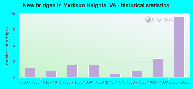
- New bridges - historical statistics
- 31930-1939
- 21940-1949
- 41950-1959
- 41960-1969
- 11970-1979
- 21980-1989
- 61990-1999
- 192000-2009
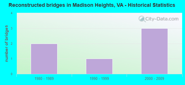
- Reconstructed bridges - Historical Statistics
- 21980-1989
- 11990-1999
- 32000-2009
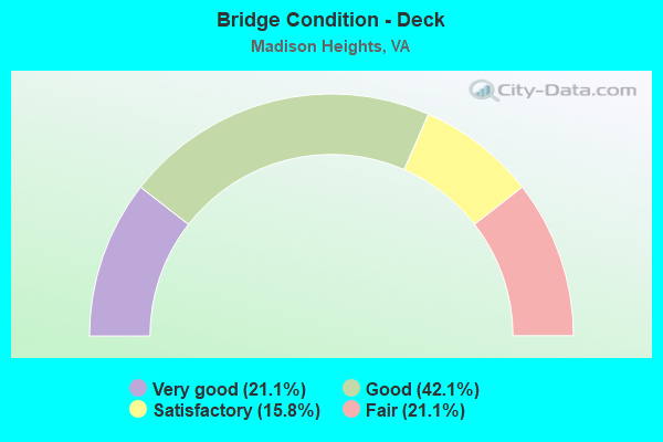
- Bridge Condition - Deck
- 21.1%Very good
- 42.1%Good
- 15.8%Satisfactory
- 21.1%Fair
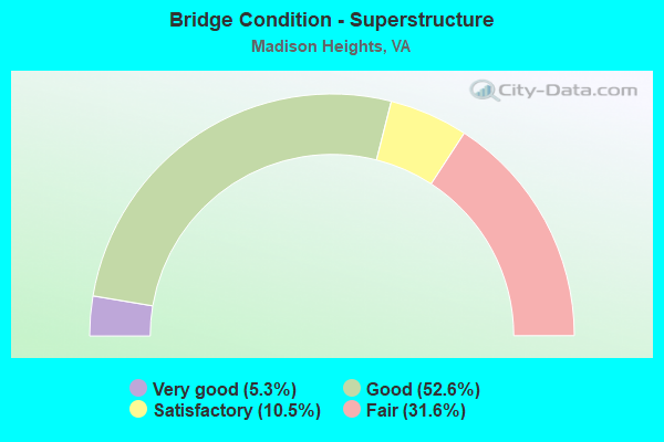
- Bridge Condition - Superstructure
- 5.3%Very good
- 52.6%Good
- 10.5%Satisfactory
- 31.6%Fair
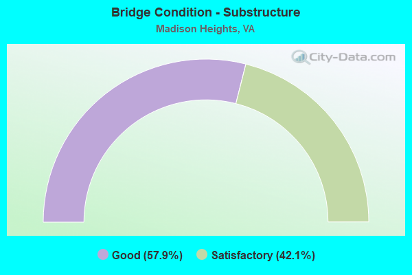
- Bridge Condition - Substructure
- 57.9%Good
- 42.1%Satisfactory
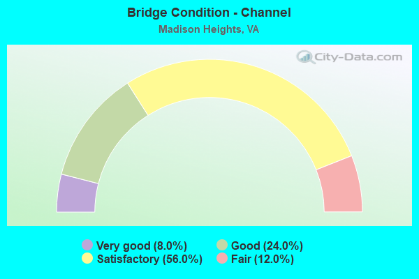
- Bridge Condition - Channel
- 8.0%Very good
- 24.0%Good
- 56.0%Satisfactory
- 12.0%Fair
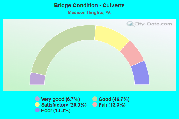
- Bridge Condition - Culverts
- 6.7%Very good
- 46.7%Good
- 20.0%Satisfactory
- 13.3%Fair
- 13.3%Poor
Find on map >> Show street view
Structure Number: 1375, Location: 0.45-Rt.795 / 0.80-Rt 704 (Lat: 37.484886, Lng: -79.165319), Route carried "on" structure: State highway 130, Year Built: 1941, Status: Open, Structure Length: 3.55m (11.65ft), Average Daily Traffic: 5,930 (year 2020), Truck Traffic: 10%, Average Future Daily Traffic: 6,523 (year 2040), Design Load: H 15, Features Intersected: Harris Creek, Facility Carried by Structure: Elon Road
Minimum Vertical Clearance: 30+ m (98+ ft), Kilometerpoint: 46.754, Lanes on structure: 2, Owner: State Highway Agency, Approaching Roadway Width: 7.6m (24.9ft), Material/Design: Steel, Design/Construction: Stringer/Multi-beam, Number Of Spans In Main Unit: 2, Length of Maximum Span: 16.7m (54.8ft), Curb or Sidewalk Widths: Left: 0.5m (1.6ft), Right: 0.5m (1.6ft), Curb-To-Curb Width: 8.1m (26.6ft), Out-to-Out Width: 9.0m (29.5ft)
Condition: Deck: Fair, Superstructure: Fair, Substructure: Good, Channel: Satisfactory, Operating Rating: 61.7 metric tons, Method Used To Determine Operating Rating: Load and Resistance Factor (LRFR), Inventory Rating: 47.2 metric tons, Method Used To Determine Inventory Rating: Load and Resistance Factor (LRFR), Structural Evaluation: Somewhat better than minimum adequacy, Deck Geometry: High priority of replacement, Waterway Adequacy: Better than present minimum criteria, Approach Roadway Alignment: Better than present minimum criteria, Length Of Structure Improvement: 4.27m (14.01ft), Designated Inspection Frequency: Every 24 months, Inspection Date: August 2021, Bridge Improvement Cost: $708,000, Roadway Improvement Cost: $71,000, Total Project Cost: $1,062,000 ( Estimate for 2014), Deck Structure Type: Concrete Cast-file-Place, Wearing Surface/Protective System: Wearing Surface: Latex Concrete
Find on map >> Show street view
Structure Number: 1376, Location: 0.65 Rt 704/0.60 Rt 795 (Lat: 37.486275, Lng: -79.166117), Route carried "on" structure: State highway 130, Year Built: 1941, Status: Open, Structure Length: 2.97m (9.74ft), Average Daily Traffic: 5,930 (year 2020), Truck Traffic: 10%, Average Future Daily Traffic: 6,523 (year 2040), Features Intersected: Graham Creek, Facility Carried by Structure: Elon Road
Minimum Vertical Clearance: 30+ m (98+ ft), Kilometerpoint: 46.600, Lanes on structure: 2, Owner: State Highway Agency, Approaching Roadway Width: 7.9m (25.9ft), Material/Design: Concrete, Design/Construction: Tee Beam, Number Of Spans In Main Unit: 3, Length of Maximum Span: 9.9m (32.5ft), Curb or Sidewalk Widths: Left: 0.5m (1.6ft), Right: 0.5m (1.6ft), Curb-To-Curb Width: 7.9m (25.9ft), Out-to-Out Width: 8.4m (27.6ft)
Condition: Deck: Fair, Superstructure: Fair, Substructure: Satisfactory, Channel: Good, Operating Rating: 59.0 metric tons, Method Used To Determine Operating Rating: Load Factor (LF), Inventory Rating: 35.4 metric tons, Method Used To Determine Inventory Rating: Load Factor (LF), Structural Evaluation: Somewhat better than minimum adequacy, Deck Geometry: High priority of replacement, Waterway Adequacy: Equal to present minimum criteria, Approach Roadway Alignment: Equal to present minimum criteria, Length Of Structure Improvement: 3.72m (12.20ft), Designated Inspection Frequency: Every 24 months, Inspection Date: July 2021, Bridge Improvement Cost: $1,066,000, Roadway Improvement Cost: $107,000, Total Project Cost: $1,599,000 ( Estimate for 2015), Deck Structure Type: Concrete Cast-file-Place, Wearing Surface/Protective System: Wearing Surface: Latex Concrete
Find on map >> Show street view
Structure Number: 1382, Location: 0.20-Rt 1375/0.20-Rt 679 (Lat: 37.473411, Lng: -79.150544), Route carried "on" structure: State highway 130, Year Built: 1952, Year Reconstructed: 1992, Status: Open, Structure Length: 3.88m (12.73ft), Average Daily Traffic: 6,037 (year 2020), Truck Traffic: 10%, Average Future Daily Traffic: 6,205 (year 2040), Features Intersected: NS Railway, Facility Carried by Structure: Elon Road
Minimum Vertical Clearance: 30+ m (98+ ft), Kilometerpoint: 48.682, Lanes on structure: 2, Owner: State Highway Agency, Approaching Roadway Width: 8.5m (27.9ft), Skew: 2 degrees, Material/Design: Steel, Design/Construction: Stringer/Multi-beam, Number Of Spans In Main Unit: 3, Length of Maximum Span: 13.9m (45.6ft), Curb or Sidewalk Widths: Left: 0.5m (1.6ft), Right: 0.5m (1.6ft), Curb-To-Curb Width: 8.5m (27.9ft), Out-to-Out Width: 9.0m (29.5ft)
Condition: Deck: Fair, Superstructure: Fair, Substructure: Satisfactory, Operating Rating: 45.4 metric tons, Method Used To Determine Operating Rating: Load and Resistance Factor (LRFR), Inventory Rating: 34.5 metric tons, Method Used To Determine Inventory Rating: Load and Resistance Factor (LRFR), Structural Evaluation: Somewhat better than minimum adequacy, Deck Geometry: High priority of replacement, Underclear: Somewhat better than minimum adequacy, Approach Roadway Alignment: Somewhat better than minimum adequacy, Length Of Structure Improvement: 5.03m (16.50ft), Designated Inspection Frequency: Every 24 months, Inspection Date: July 2021, Bridge Improvement Cost: $508,000, Roadway Improvement Cost: $51,000, Total Project Cost: $762,000 ( Estimate for 2015), Deck Structure Type: Concrete Cast-file-Place, Wearing Surface/Protective System: Wearing Surface: Latex Concrete
Find on map >> Show street view
Structure Number: 1446, Location: 1.20-Rt.814/6.90-Rt.604 (Lat: 37.481003, Lng: -78.993142), Route carried "on" structure: County highway 624, Year Built: 1930, Status: Posted for load, Structure Length: 1.21m (3.97ft), Average Daily Traffic: 199 (year 2020), Average Future Daily Traffic: 219 (year 2040), Features Intersected: Partridge Creek, Facility Carried by Structure: Earley Farm Road
Minimum Vertical Clearance: 30+ m (98+ ft), Kilometerpoint: 15.125, Lanes on structure: 1, Owner: State Highway Agency, Approaching Roadway Width: 4.3m (14.1ft), Material/Design: Steel, Design/Construction: Stringer/Multi-beam, Number Of Spans In Main Unit: 2, Length of Maximum Span: 5.7m (18.7ft), Curb or Sidewalk Widths: Left: 0.2m (0.7ft), Right: 0.2m (0.7ft), Curb-To-Curb Width: 4.1m (13.5ft), Out-to-Out Width: 4.4m (14.4ft)
Condition: Deck: Fair, Superstructure: Satisfactory, Substructure: Satisfactory, Channel: Satisfactory, Operating Rating: 28.1 metric tons, Method Used To Determine Operating Rating: Load Factor (LF), Inventory Rating: 17.2 metric tons, Method Used To Determine Inventory Rating: Load Factor (LF), Structural Evaluation: Somewhat better than minimum adequacy, Deck Geometry: High priority of replacement, Waterway Adequacy: Somewhat better than minimum adequacy, Approach Roadway Alignment: High priority of corrective action, Bridge Posting: Required (Relationship of Operating Rating to Maximum Legal Load: 30.0 - 39.9% below), Length Of Structure Improvement: 1.89m (6.20ft), Designated Inspection Frequency: Every 12 months, Inspection Date: November 2021, Bridge Improvement Cost: $330,000, Roadway Improvement Cost: $33,000, Total Project Cost: $495,000 ( Estimate for 2015), Deck Structure Type: Wood or Timber, Wearing Surface/Protective System: Wearing Surface: Bituminous
Find on map >> Show street view
Structure Number: 1476, Location: .65-Rt.656/.32-Rt.657 (Lat: 37.524378, Lng: -79.138586), Route carried "on" structure: County highway 636, Year Built: 1959, Status: Open, Structure Length: 3.98m (13.06ft), Average Daily Traffic: 1,322 (year 2020), Truck Traffic: 2%, Average Future Daily Traffic: 1,454 (year 2040), Design Load: HS 15, Features Intersected: Harris Creek, Facility Carried by Structure: High Peak Road
Minimum Vertical Clearance: 30+ m (98+ ft), Kilometerpoint: 2.011, Lanes on structure: 2, Owner: State Highway Agency, Approaching Roadway Width: 6.7m (22.0ft), Skew: 4 degrees, Material/Design: Concrete, Design/Construction: Tee Beam, Number Of Spans In Main Unit: 3, Length of Maximum Span: 13.0m (42.7ft), Curb or Sidewalk Widths: Left: 0.5m (1.6ft), Right: 0.5m (1.6ft), Curb-To-Curb Width: 7.3m (24.0ft), Out-to-Out Width: 8.8m (28.9ft)
Condition: Deck: Satisfactory, Superstructure: Fair, Substructure: Satisfactory, Channel: Good, Operating Rating: 56.2 metric tons, Method Used To Determine Operating Rating: Load and Resistance Factor (LRFR), Inventory Rating: 43.5 metric tons, Method Used To Determine Inventory Rating: Load and Resistance Factor (LRFR), Structural Evaluation: Somewhat better than minimum adequacy, Deck Geometry: Meets minimum limits, Waterway Adequacy: Somewhat better than minimum adequacy, Approach Roadway Alignment: Equal to present desirable criteria, Length Of Structure Improvement: 4.75m (15.58ft), Designated Inspection Frequency: Every 24 months, Inspection Date: November 2021, Bridge Improvement Cost: $480,000, Roadway Improvement Cost: $48,000, Total Project Cost: $720,000 ( Estimate for 2015), Deck Structure Type: Concrete Cast-file-Place, Wearing Surface/Protective System: Wearing Surface: Epoxy Overlay
Find on map >> Show street view
Structure Number: 1496, Location: .70-Rt.657/.40-Rt.675 (Lat: 37.521519, Lng: -79.159814), Route carried "on" structure: County highway 652, Year Built: 1980, Status: Open, Structure Length: 0.85m (2.79ft), Average Daily Traffic: 874 (year 2016), Truck Traffic: 4%, Average Future Daily Traffic: 1,294 (year 2040), Features Intersected: Muddy Creek, Facility Carried by Structure: Cedar Gate Road
Minimum Vertical Clearance: 30+ m (98+ ft), Kilometerpoint: 1.126, Lanes on structure: 2, Owner: State Highway Agency, Approaching Roadway Width: 6.1m (20.0ft), Skew: 3 degrees, Material/Design: Steel, Design/Construction: Culvert, Number Of Spans In Main Unit: 2, Length of Maximum Span: 3.7m (12.1ft)
Condition: Channel: Satisfactory, Culverts: Poor, Operating Rating: 89.8 metric tons, Method Used To Determine Operating Rating: Load Factor (LF), Inventory Rating: 89.8 metric tons, Method Used To Determine Inventory Rating: Load Factor (LF), Structural Evaluation: Meets minimum limits, Waterway Adequacy: Equal to present desirable criteria, Approach Roadway Alignment: Equal to present desirable criteria, Designated Inspection Frequency: Every 12 months, Inspection Date: March 2022
Find on map >> Show street view
Structure Number: 1504, Location: 0.31-Rt.707/0.01-Rt. 807 (Lat: 37.501133, Lng: -79.135650), Route carried "on" structure: County highway 657, Year Built: 1966, Status: Open, Structure Length: 2.94m (9.65ft), Average Daily Traffic: 448 (year 2020), Truck Traffic: 3%, Average Future Daily Traffic: 493 (year 2040), Features Intersected: Harris Creek, Facility Carried by Structure: Cedar Gate Road
Minimum Vertical Clearance: 30+ m (98+ ft), Kilometerpoint: 4.364, Lanes on structure: 2, Owner: State Highway Agency, Approaching Roadway Width: 7.3m (24.0ft), Material/Design: Concrete, Design/Construction: Tee Beam, Number Of Spans In Main Unit: 2, Length of Maximum Span: 14.7m (48.2ft), Curb or Sidewalk Widths: Left: 0.5m (1.6ft), Right: 0.5m (1.6ft), Curb-To-Curb Width: 8.1m (26.6ft), Out-to-Out Width: 9.1m (29.9ft)
Condition: Deck: Satisfactory, Superstructure: Good, Substructure: Good, Channel: Satisfactory, Operating Rating: 57.2 metric tons, Method Used To Determine Operating Rating: Load and Resistance Factor (LRFR), Inventory Rating: 43.5 metric tons, Method Used To Determine Inventory Rating: Load and Resistance Factor (LRFR), Structural Evaluation: Better than present minimum criteria, Deck Geometry: Somewhat better than minimum adequacy, Waterway Adequacy: Better than present minimum criteria, Approach Roadway Alignment: Equal to present desirable criteria, Designated Inspection Frequency: Every 24 months, Inspection Date: September 2021, Deck Structure Type: Concrete Cast-file-Place
Find on map >> Show street view
Structure Number: 1511, Location: 0.00-Rt 648/1.20-Rt 622 (Lat: 37.458186, Lng: -79.047356), Route carried "on" structure: County highway 663, Year Built: 1932, Year Reconstructed: 2013, Status: Open, Structure Length: 0.95m (3.12ft), Average Daily Traffic: 203 (year 2019), Average Future Daily Traffic: 224 (year 2040), Features Intersected: Beck Creek, Facility Carried by Structure: Brightwells Mill R
Minimum Vertical Clearance: 30+ m (98+ ft), Kilometerpoint: 19.936, Lanes on structure: 2, Owner: State Highway Agency, Approaching Roadway Width: 5.5m (18.0ft), Material/Design: Concrete, Design/Construction: Slab, Number Of Spans In Main Unit: 1, Length of Maximum Span: 8.5m (27.9ft), Curb-To-Curb Width: 7.2m (23.6ft), Out-to-Out Width: 7.3m (24.0ft)
Condition: Deck: Very good, Superstructure: Very good, Substructure: Good, Channel: Satisfactory, Operating Rating: 90.7 metric tons, Method Used To Determine Operating Rating: Load and Resistance Factor (LRFR), Inventory Rating: 69.9 metric tons, Method Used To Determine Inventory Rating: Load and Resistance Factor (LRFR), Structural Evaluation: Better than present minimum criteria, Deck Geometry: Meets minimum limits, Waterway Adequacy: Equal to present minimum criteria, Approach Roadway Alignment: High priority of corrective action, Designated Inspection Frequency: Every 24 months, Inspection Date: May 2021, Deck Structure Type: Concrete Precast Panels, Wearing Surface/Protective System: Wearing Surface: Bituminous
Find on map >> Show street view
Structure Number: 1514, Location: .53-Rt 663 / 1.17-Rt 670 (Lat: 37.462297, Lng: -79.057425), Route carried "on" structure: County highway 669, Year Built: 1960, Year Reconstructed: 1994, Status: Posted for load, Structure Length: 1.28m (4.20ft), Average Daily Traffic: 124 (year 2016), Average Future Daily Traffic: 141 (year 2040), Features Intersected: Stovall Creek, Facility Carried by Structure: Glade Road
Minimum Vertical Clearance: 30+ m (98+ ft), Kilometerpoint: 7.128, Lanes on structure: 1, Owner: State Highway Agency, Approaching Roadway Width: 4.4m (14.4ft), Skew: 2 degrees, Material/Design: Steel, Design/Construction: Stringer/Multi-beam, Number Of Spans In Main Unit: 1, Length of Maximum Span: 11.2m (36.7ft), Curb or Sidewalk Widths: Left: 0.2m (0.7ft), Right: 0.2m (0.7ft), Curb-To-Curb Width: 4.0m (13.1ft), Out-to-Out Width: 4.6m (15.1ft)
Condition: Deck: Good, Superstructure: Fair, Substructure: Satisfactory, Channel: Very good, Operating Rating: 31.8 metric tons, Method Used To Determine Operating Rating: Load Factor (LF), Inventory Rating: 19.1 metric tons, Method Used To Determine Inventory Rating: Load Factor (LF), Structural Evaluation: Somewhat better than minimum adequacy, Deck Geometry: High priority of replacement, Waterway Adequacy: Better than present minimum criteria, Approach Roadway Alignment: Equal to present minimum criteria, Length Of Structure Improvement: 1.86m (6.10ft), Designated Inspection Frequency: Every 12 months, Inspection Date: September 2021, Bridge Improvement Cost: $325,000, Roadway Improvement Cost: $33,000, Total Project Cost: $487,000 ( Estimate for 2015), Deck Structure Type: Wood or Timber, Wearing Surface/Protective System: Wearing Surface: Bituminous
Find on map >> Show street view
Structure Number: 1521, Location: .35-Rt.1430/2.37-Rt.652 (Lat: 37.493531, Lng: -79.152933), Route carried "on" structure: County highway 675, Year Built: 1956, Status: Open, Structure Length: 3.96m (12.99ft), Average Daily Traffic: 365 (year 2020), Truck Traffic: 2%, Average Future Daily Traffic: 450 (year 2040), Features Intersected: Harris Creek, Facility Carried by Structure: Winesap Road
Minimum Vertical Clearance: 30+ m (98+ ft), Kilometerpoint: 5.271, Lanes on structure: 2, Owner: State Highway Agency, Approaching Roadway Width: 5.2m (17.1ft), Skew: 3 degrees, Material/Design: Concrete, Design/Construction: Tee Beam, Number Of Spans In Main Unit: 3, Length of Maximum Span: 12.0m (39.4ft), Curb or Sidewalk Widths: Left: 0.3m (1.0ft), Right: 0.3m (1.0ft), Curb-To-Curb Width: 6.1m (20.0ft), Out-to-Out Width: 6.8m (22.3ft)
Condition: Deck: Good, Superstructure: Fair, Substructure: Satisfactory, Channel: Fair, Operating Rating: 43.5 metric tons, Method Used To Determine Operating Rating: Load Factor (LF), Inventory Rating: 26.3 metric tons, Method Used To Determine Inventory Rating: Load Factor (LF), Structural Evaluation: Somewhat better than minimum adequacy, Deck Geometry: Meets minimum limits, Waterway Adequacy: Better than present minimum criteria, Approach Roadway Alignment: Equal to present desirable criteria, Length Of Structure Improvement: 4.75m (15.58ft), Designated Inspection Frequency: Every 24 months, Inspection Date: March 2020, Bridge Improvement Cost: $830,000, Roadway Improvement Cost: $83,000, Total Project Cost: $1,245,000 ( Estimate for 2014), Deck Structure Type: Concrete Cast-file-Place, Wearing Surface/Protective System: Wearing Surface: Bituminous
Find on map >> Show street view
Structure Number: 1522, Location: 0.03-Rt 795/0.51-Rt 805 (Lat: 37.485358, Lng: -79.147497), Route carried "on" structure: County highway 675, Year Built: 1962, Year Reconstructed: 1997, Status: Open, Structure Length: 7.69m (25.23ft), Average Daily Traffic: 991 (year 2020), Average Future Daily Traffic: 1,090 (year 2040), Features Intersected: NS Railway, Facility Carried by Structure: Winesap Road
Minimum Vertical Clearance: 30+ m (98+ ft), Kilometerpoint: 6.312, Lanes on structure: 2, Owner: State Highway Agency, Approaching Roadway Width: 10.4m (34.1ft), Skew: 1 degrees, Material/Design: Steel, Design/Construction: Stringer/Multi-beam, Number Of Spans In Main Unit: 3, Length of Maximum Span: 26.7m (87.6ft), Curb-To-Curb Width: 8.5m (27.9ft), Out-to-Out Width: 9.5m (31.2ft)
Condition: Deck: Good, Superstructure: Satisfactory, Substructure: Satisfactory, Operating Rating: 77.1 metric tons, Method Used To Determine Operating Rating: Load and Resistance Factor (LRFR), Inventory Rating: 59.9 metric tons, Method Used To Determine Inventory Rating: Load and Resistance Factor (LRFR), Structural Evaluation: Equal to present minimum criteria, Deck Geometry: Somewhat better than minimum adequacy, Underclear: Somewhat better than minimum adequacy, Approach Roadway Alignment: Equal to present minimum criteria, Designated Inspection Frequency: Every 24 months, Inspection Date: October 2021, Deck Structure Type: Concrete Cast-file-Place, Wearing Surface/Protective System: Deck Protection: Epoxy Coated Reinforcing
Find on map >> Show street view
Structure Number: 1524, Location: 0.09-Rt.1054/0.01-Rt.1048 (Lat: 37.433036, Lng: -79.111756), Route carried "on" structure: County highway 681, Year Built: 1954, Status: Open, Structure Length: 1.36m (4.46ft), Average Daily Traffic: 3,045 (year 2020), Truck Traffic: 1%, Average Future Daily Traffic: 3,350 (year 2040), Features Intersected: Williams Run, Facility Carried by Structure: Seminole Drive
Minimum Vertical Clearance: 30+ m (98+ ft), Kilometerpoint: 1.834, Lanes on structure: 2, Owner: State Highway Agency, Approaching Roadway Width: 7.0m (23.0ft), Material/Design: Steel, Design/Construction: Stringer/Multi-beam, Number Of Spans In Main Unit: 1, Length of Maximum Span: 12.2m (40.0ft), Curb or Sidewalk Widths: Left: 0.3m (1.0ft), Right: 0.3m (1.0ft), Curb-To-Curb Width: 10.3m (33.8ft), Out-to-Out Width: 10.9m (35.8ft)
Condition: Deck: Very good, Superstructure: Good, Substructure: Satisfactory, Channel: Satisfactory, Operating Rating: 40.8 metric tons, Method Used To Determine Operating Rating: Load and Resistance Factor (LRFR), Inventory Rating: 31.8 metric tons, Method Used To Determine Inventory Rating: Load and Resistance Factor (LRFR), Structural Evaluation: Equal to present minimum criteria, Deck Geometry: Meets minimum limits, Waterway Adequacy: Better than present minimum criteria, Approach Roadway Alignment: Equal to present minimum criteria, Length Of Structure Improvement: 2.01m (6.59ft), Designated Inspection Frequency: Every 24 months, Inspection Date: January 2022, Bridge Improvement Cost: $351,000, Roadway Improvement Cost: $35,000, Total Project Cost: $527,000 ( Estimate for 2014), Deck Structure Type: Concrete Cast-file-Place
Find on map >> Show street view
Structure Number: 1535, Location: .15-Rt 705 / .88-Rt 1309 (Lat: 37.472350, Lng: -79.140444), Route carried "on" structure: County highway 730, Year Built: 1980, Year Reconstructed: 2006, Status: Open, Structure Length: 0.77m (2.53ft), Average Daily Traffic: 163 (year 2016), Average Future Daily Traffic: 183 (year 2040), Features Intersected: Fawn Creek, Facility Carried by Structure: Oak Grove Road
Minimum Vertical Clearance: 30+ m (98+ ft), Kilometerpoint: 0.235, Lanes on structure: 2, Owner: State Highway Agency, Approaching Roadway Width: 5.5m (18.0ft), Skew: 6 degrees, Material/Design: Steel, Design/Construction: Culvert, Number Of Spans In Main Unit: 2, Length of Maximum Span: 3.0m (9.8ft)
Condition: Channel: Fair, Culverts: Very good, Operating Rating: 51.7 metric tons, Method Used To Determine Operating Rating: Field evaluation and documented engineering judgment, Inventory Rating: 30.8 metric tons, Method Used To Determine Inventory Rating: Field evaluation and documented engineering judgment, Structural Evaluation: Better than present minimum criteria, Waterway Adequacy: Equal to present desirable criteria, Approach Roadway Alignment: Equal to present minimum criteria, Designated Inspection Frequency: Every 24 months, Inspection Date: November 2020
Find on map >> Show street view
Structure Number: 1564, Location: 0.07-Rt 1203/0.05-Rt 671 (Lat: 37.506642, Lng: -79.121758), Route carried "on" structure: County highway 1214, Year Built: 1932, Status: Open, Structure Length: 0.64m (2.10ft), Average Daily Traffic: 173 (year 2020), Truck Traffic: 6%, Average Future Daily Traffic: 190 (year 2040), Features Intersected: Harris Creek, Facility Carried by Structure: Francis Avenue
Minimum Vertical Clearance: 30+ m (98+ ft), Kilometerpoint: 0.563, Lanes on structure: 2, Owner: State Highway Agency, Approaching Roadway Width: 8.8m (28.9ft), Material/Design: Concrete, Design/Construction: Culvert, Number Of Spans In Main Unit: 2, Length of Maximum Span: 3.0m (9.8ft)
Condition: Channel: Good, Culverts: Fair, Operating Rating: 89.8 metric tons, Method Used To Determine Operating Rating: Load Factor (LF), Inventory Rating: 89.8 metric tons, Method Used To Determine Inventory Rating: Load Factor (LF), Structural Evaluation: Somewhat better than minimum adequacy, Waterway Adequacy: Better than present minimum criteria, Approach Roadway Alignment: Equal to present desirable criteria, Designated Inspection Frequency: Every 24 months, Inspection Date: July 2020
Find on map >> Show street view
Structure Number: 1566, Location: 0.15-Rt 1349/0.15-Rt 1325 (Lat: 37.477428, Lng: -79.090375), Route carried "on" structure: County highway 1348, Year Built: 1978, Year Reconstructed: 2011, Status: Open, Structure Length: 0.76m (2.49ft), Average Daily Traffic: 254 (year 2019), Average Future Daily Traffic: 295 (year 2040), Features Intersected: Br Middle F Stovall Crk, Facility Carried by Structure: Wood Haven Ct.
Minimum Vertical Clearance: 30+ m (98+ ft), Kilometerpoint: 0.209, Lanes on structure: 2, Owner: State Highway Agency, Approaching Roadway Width: 5.8m (19.0ft), Material/Design: Steel, Design/Construction: Culvert, Number Of Spans In Main Unit: 3, Length of Maximum Span: 2.4m (7.9ft)
Condition: Channel: Satisfactory, Culverts: Good, Operating Rating: 51.7 metric tons, Method Used To Determine Operating Rating: Field evaluation and documented engineering judgment, Inventory Rating: 30.8 metric tons, Method Used To Determine Inventory Rating: Field evaluation and documented engineering judgment, Structural Evaluation: Better than present minimum criteria, Waterway Adequacy: Equal to present desirable criteria, Approach Roadway Alignment: Equal to present desirable criteria, Designated Inspection Frequency: Every 24 months, Inspection Date: June 2021
Find on map >> Show street view
Structure Number: 23286, Location: 0.01-Rt 1212/0.03-Rt 707 (Lat: 37.497953, Lng: -79.131522), Route carried "on" structure: County highway 657, Year Built: 1991, Status: Open, Structure Length: 6.16m (20.21ft), Average Daily Traffic: 575 (year 2020), Truck Traffic: 5%, Average Future Daily Traffic: 632 (year 2040), Design Load: HS 20+Mod, Features Intersected: NS Railway, Facility Carried by Structure: Cedar Gate Road
Minimum Vertical Clearance: 30+ m (98+ ft), Kilometerpoint: 4.479, Lanes on structure: 2, Owner: State Highway Agency, Approaching Roadway Width: 12.2m (40.0ft), Skew: 1 degrees, Material/Design: Steel, Design/Construction: Stringer/Multi-beam, Number Of Spans In Main Unit: 3, Length of Maximum Span: 24.4m (80.1ft), Curb-To-Curb Width: 8.5m (27.9ft), Out-to-Out Width: 9.5m (31.2ft)
Condition: Deck: Good, Superstructure: Good, Substructure: Good, Operating Rating: 83.5 metric tons, Method Used To Determine Operating Rating: Load and Resistance Factor (LRFR), Inventory Rating: 64.4 metric tons, Method Used To Determine Inventory Rating: Load and Resistance Factor (LRFR), Structural Evaluation: Better than present minimum criteria, Approach Roadway Alignment: Equal to present desirable criteria, Designated Inspection Frequency: Every 24 months, Inspection Date: October 2021, Deck Structure Type: Concrete Cast-file-Place, Wearing Surface/Protective System: Wearing Surface: Epoxy Overlay, Deck Protection: Epoxy Coated Reinforcing
Find on map >> Show street view
Structure Number: 24498, Location: .40-Rt 683/.10-Rt 684 (Lat: 37.435547, Lng: -79.146478), Route carried "on" structure: County highway 685, Year Built: 1995, Status: Open, Structure Length: 0.61m (2.00ft), Average Daily Traffic: 765 (year 2020), Truck Traffic: 1%, Average Future Daily Traffic: 842 (year 2040), Features Intersected: Buck Branch, Facility Carried by Structure: River Road
Minimum Vertical Clearance: 30+ m (98+ ft), Kilometerpoint: 8.230, Lanes on structure: 2, Owner: State Highway Agency, Approaching Roadway Width: 6.4m (21.0ft), Material/Design: Steel, Design/Construction: Arch - Deck, Number Of Spans In Main Unit: 1, Length of Maximum Span: 6.1m (20.0ft), Curb-To-Curb Width: 9.8m (32.2ft), Out-to-Out Width: 9.8m (32.2ft)
Condition: Deck: Very good, Superstructure: Good, Substructure: Good, Channel: Very good, Operating Rating: 89.8 metric tons, Method Used To Determine Operating Rating: Load Factor (LF), Inventory Rating: 89.8 metric tons, Method Used To Determine Inventory Rating: Load Factor (LF), Structural Evaluation: Better than present minimum criteria, Deck Geometry: Equal to present minimum criteria, Waterway Adequacy: Equal to present desirable criteria, Approach Roadway Alignment: Equal to present desirable criteria, Designated Inspection Frequency: Every 24 months, Inspection Date: March 2020
Find on map >> Show street view
Structure Number: 25252, Location: 0.80-Rt 663/0.40-Rt 613 (Lat: 37.457864, Lng: -79.036008), Route carried "on" structure: County highway 648, Year Built: 1997, Status: Open, Structure Length: 0.73m (2.40ft), Average Daily Traffic: 90 (year 2016), Average Future Daily Traffic: 140 (year 2040), Features Intersected: Branch Beck Creek, Facility Carried by Structure: Beck Creek Road
Minimum Vertical Clearance: 30+ m (98+ ft), Kilometerpoint: 3.390, Lanes on structure: 2, Owner: State Highway Agency, Approaching Roadway Width: 6.1m (20.0ft), Skew: 3 degrees, Material/Design: Steel, Design/Construction: Culvert, Number Of Spans In Main Unit: 2, Length of Maximum Span: 3.2m (10.5ft)
Condition: Channel: Satisfactory, Culverts: Poor, Operating Rating: 52.6 metric tons, Method Used To Determine Operating Rating: Field evaluation and documented engineering judgment, Inventory Rating: 31.8 metric tons, Method Used To Determine Inventory Rating: Field evaluation and documented engineering judgment, Structural Evaluation: Meets minimum limits, Waterway Adequacy: Equal to present minimum criteria, Approach Roadway Alignment: Equal to present desirable criteria, Designated Inspection Frequency: Every 12 months, Inspection Date: March 2022
Find on map >> Show street view
Structure Number: 25613, Location: 0.04-Rt 1216/0.35-Rt 699 (Lat: 37.510631, Lng: -79.120439), Route carried "on" structure: County highway 671, Year Built: 1999, Status: Open, Structure Length: 6.10m (20.01ft), Average Daily Traffic: 1,649 (year 2020), Truck Traffic: 2%, Average Future Daily Traffic: 1,814 (year 2040), Design Load: HS 20+Mod, Features Intersected: NS Railway, Facility Carried by Structure: Five Forks Road
Minimum Vertical Clearance: 30+ m (98+ ft), Kilometerpoint: 6.243, Lanes on structure: 2, Owner: State Highway Agency, Approaching Roadway Width: 9.8m (32.2ft), Skew: 4 degrees, Material/Design: Steel, Design/Construction: Stringer/Multi-beam, Number Of Spans In Main Unit: 3, Length of Maximum Span: 28.7m (94.2ft), Curb-To-Curb Width: 12.2m (40.0ft), Out-to-Out Width: 13.2m (43.3ft)
Condition: Deck: Satisfactory, Superstructure: Good, Substructure: Good, Operating Rating: 72.6 metric tons, Method Used To Determine Operating Rating: Load and Resistance Factor (LRFR), Inventory Rating: 56.2 metric tons, Method Used To Determine Inventory Rating: Load and Resistance Factor (LRFR), Structural Evaluation: Better than present minimum criteria, Deck Geometry: Better than present minimum criteria, Underclear: Superior to present desirable criteria, Approach Roadway Alignment: Equal to present desirable criteria, Designated Inspection Frequency: Every 24 months, Inspection Date: October 2021, Deck Structure Type: Concrete Cast-file-Place, Wearing Surface/Protective System: Deck Protection: Epoxy Coated Reinforcing
Find on map >> Show street view
Structure Number: 25927, Location: 2.10-Rt 622/.45-EndStMain (Lat: 37.407875, Lng: -79.084633), Route carried "on" structure: State highway 210, Year Built: 2003, Status: Open, Structure Length: 7.41m (24.31ft), Average Daily Traffic: 6,761 (year 2020), Truck Traffic: 4%, Average Future Daily Traffic: 9,465 (year 2040), Design Load: HS 20+Mod, Features Intersected: Route 29 NBL&SBL, Facility Carried by Structure: Colony Road
Minimum Vertical Clearance: 6.32m (20.73ft), Kilometerpoint: 123.056, Lanes on structure: 2, Lanes under structure: 4, Owner: State Highway Agency, Approaching Roadway Width: 13.4m (44.0ft), Material/Design: Concrete, Design/Construction: Slab, Number Of Spans In Main Unit: 2, Length of Maximum Span: 39.0m (128.0ft), Curb or Sidewalk Widths: Left: 0.4m (1.3ft), Right: 0.4m (1.3ft), Curb-To-Curb Width: 13.6m (44.6ft), Out-to-Out Width: 14.3m (46.9ft)
Condition: Deck: Good, Superstructure: Good, Substructure: Good, Operating Rating: 55.0 metric tons, Method Used To Determine Operating Rating: Load and Resistance Factor (LRFR), Inventory Rating: 42.0 metric tons, Method Used To Determine Inventory Rating: Load and Resistance Factor (LRFR), Structural Evaluation: Better than present minimum criteria, Deck Geometry: Superior to present desirable criteria, Underclear: Equal to present minimum criteria, Approach Roadway Alignment: Equal to present desirable criteria, Designated Inspection Frequency: Every 24 months, Inspection Date: May 2020, Deck Structure Type: Concrete Cast-file-Place, Wearing Surface/Protective System: Wearing Surface: Epoxy Overlay, Deck Protection: Epoxy Coated Reinforcing
Find on map >> Show street view
Structure Number: 25929, Location: .83-Rt 677 / 1.17-Rt 663 (Lat: 37.443350, Lng: -79.076833), Route carried "on" structure: County highway 622, Year Built: 2003, Status: Open, Structure Length: 9.51m (31.20ft), Average Daily Traffic: 1,226 (year 2020), Truck Traffic: 1%, Average Future Daily Traffic: 1,349 (year 2040), Design Load: HS 20+Mod, Features Intersected: Route 29 Bypass, Facility Carried by Structure: Galts Mill Road
Minimum Vertical Clearance: 30+ m (98+ ft), Kilometerpoint: 5.052, Lanes on structure: 2, Lanes under structure: 5, Owner: State Highway Agency, Approaching Roadway Width: 12.0m (39.4ft), Material/Design: Steel continuous, Design/Construction: Stringer/Multi-beam, Number Of Spans In Main Unit: 2, Length of Maximum Span: 47.5m (155.8ft), Curb-To-Curb Width: 12.3m (40.4ft), Out-to-Out Width: 13.3m (43.6ft)
Condition: Deck: Good, Superstructure: Good, Substructure: Good, Operating Rating: 71.7 metric tons, Method Used To Determine Operating Rating: Load and Resistance Factor (LRFR), Inventory Rating: 55.3 metric tons, Method Used To Determine Inventory Rating: Load and Resistance Factor (LRFR), Structural Evaluation: Better than present minimum criteria, Deck Geometry: Better than present minimum criteria, Underclear: Equal to present minimum criteria, Approach Roadway Alignment: Equal to present minimum criteria, Designated Inspection Frequency: Every 24 months, Inspection Date: September 2021, Deck Structure Type: Concrete Cast-file-Place, Wearing Surface/Protective System: Deck Protection: Epoxy Coated Reinforcing
Find on map >> Show street view
Structure Number: 2593, Location: 0.21-Rt 130/6.88-Rt 29 (Lat: 37.465772, Lng: -79.083272), Route carried "on" structure: Bypass US 29, Year Built: 2005, Status: Open, Structure Length: 1.19m (3.90ft), Average Daily Traffic: 14,503 (year 2020), Truck Traffic: 10%, Average Future Daily Traffic: 20,303 (year 2040), Features Intersected: South Fork Stovall Creek
Minimum Vertical Clearance: 30+ m (98+ ft), Kilometerpoint: 129.476, Lanes on structure: 4, Base Highway Network: Yes, Owner: State Highway Agency, Approaching Roadway Width: 16.2m (53.1ft), Skew: 4 degrees, Material/Design: Concrete, Design/Construction: Culvert, Number Of Spans In Main Unit: 3, Length of Maximum Span: 4.0m (13.1ft)
Condition: Channel: Satisfactory, Culverts: Satisfactory, Operating Rating: 89.8 metric tons, Method Used To Determine Operating Rating: Load Factor (LF), Inventory Rating: 89.8 metric tons, Method Used To Determine Inventory Rating: Load Factor (LF), Structural Evaluation: Equal to present minimum criteria, Waterway Adequacy: Equal to present desirable criteria, Approach Roadway Alignment: Equal to present desirable criteria, Designated Inspection Frequency: Every 24 months, Inspection Date: July 2021
Find on map >> Show street view
Structure Number: 25931, Location: .10 RT 130 / .35 RT 671 (Lat: 37.464894, Lng: -79.088067), Route carried "on" structure: County highway 677, Year Built: 2003, Status: Open, Structure Length: 0.94m (3.08ft), Average Daily Traffic: 2,855 (year 2020), Truck Traffic: 2%, Average Future Daily Traffic: 3,997 (year 2040), Design Load: HS 20, Features Intersected: S Fk Stovalls Creek, Facility Carried by Structure: Dixie Airport Road
Minimum Vertical Clearance: 30+ m (98+ ft), Kilometerpoint: 0.000, Lanes on structure: 2, Owner: State Highway Agency, Approaching Roadway Width: 8.2m (26.9ft), Skew: 1 degrees, Material/Design: Concrete, Design/Construction: Culvert, Number Of Spans In Main Unit: 3, Length of Maximum Span: 3.1m (10.2ft)
Condition: Channel: Satisfactory, Culverts: Good, Operating Rating: 63.5 metric tons, Method Used To Determine Operating Rating: Load Factor (LF), Inventory Rating: 38.1 metric tons, Method Used To Determine Inventory Rating: Load Factor (LF), Structural Evaluation: Better than present minimum criteria, Waterway Adequacy: Better than present minimum criteria, Approach Roadway Alignment: Equal to present minimum criteria, Designated Inspection Frequency: Every 24 months, Inspection Date: July 2021
Find on map >> Show street view
Structure Number: 25955, Location: 1.04-Rt 130/6.05-Rt 29 B (Lat: 37.476981, Lng: -79.077497), Route carried "on" structure: Bypass US 29, Year Built: 2005, Status: Open, Structure Length: 1.62m (5.31ft), Average Daily Traffic: 14,503 (year 2020), Truck Traffic: 10%, Average Future Daily Traffic: 20,303 (year 2040), Features Intersected: Middle Fork Stovall Crk
Minimum Vertical Clearance: 30+ m (98+ ft), Kilometerpoint: 131.162, Lanes on structure: 4, Base Highway Network: Yes, Owner: State Highway Agency, Approaching Roadway Width: 11.6m (38.1ft), Skew: 10 degrees, Material/Design: Concrete, Design/Construction: Culvert, Number Of Spans In Main Unit: 3, Length of Maximum Span: 4.0m (13.1ft)
Condition: Channel: Good, Culverts: Satisfactory, Operating Rating: 89.8 metric tons, Method Used To Determine Operating Rating: Load Factor (LF), Inventory Rating: 89.8 metric tons, Method Used To Determine Inventory Rating: Load Factor (LF), Structural Evaluation: Equal to present minimum criteria, Waterway Adequacy: Equal to present desirable criteria, Approach Roadway Alignment: Equal to present desirable criteria, Designated Inspection Frequency: Every 24 months, Inspection Date: July 2021
Find on map >> Show street view
Structure Number: 25957, Location: 0.20-Rt.671/0.10-Rt.670 (Lat: 37.472222, Lng: -79.081111), Route carried "on" structure: County highway 701, Year Built: 2005, Status: Open, Structure Length: 8.75m (28.71ft), Average Daily Traffic: 286 (year 2016), Average Future Daily Traffic: 351 (year 2040), Design Load: HS 20+Mod, Features Intersected: Route 29 Bypass, Facility Carried by Structure: Dogwood Drive
Minimum Vertical Clearance: 30+ m (98+ ft), Kilometerpoint: 0.000, Lanes on structure: 2, Lanes under structure: 4, Owner: State Highway Agency, Approaching Roadway Width: 8.2m (26.9ft), Skew: 2 degrees, Material/Design: Steel continuous, Design/Construction: Stringer/Multi-beam, Number Of Spans In Main Unit: 2, Length of Maximum Span: 47.2m (154.9ft), Curb-To-Curb Width: 9.0m (29.5ft), Out-to-Out Width: 10.0m (32.8ft)
Condition: Deck: Good, Superstructure: Good, Substructure: Good, Operating Rating: 70.8 metric tons, Method Used To Determine Operating Rating: Load and Resistance Factor (LRFR), Inventory Rating: 54.4 metric tons, Method Used To Determine Inventory Rating: Load and Resistance Factor (LRFR), Structural Evaluation: Better than present minimum criteria, Deck Geometry: Equal to present minimum criteria, Underclear: Equal to present minimum criteria, Approach Roadway Alignment: Equal to present desirable criteria, Designated Inspection Frequency: Every 24 months, Inspection Date: May 2021, Deck Structure Type: Concrete Cast-file-Place, Wearing Surface/Protective System: Deck Protection: Epoxy Coated Reinforcing
Find on map >> Show street view
Structure Number: 25958, Location: 1.20-Rt 604 / 0.90-Rt 670 (Lat: 37.503978, Lng: -79.066517), Route carried "on" structure: County highway 663, Year Built: 2004, Status: Open, Structure Length: 8.38m (27.49ft), Average Daily Traffic: 669 (year 2020), Truck Traffic: 5%, Average Future Daily Traffic: 736 (year 2040), Design Load: HS 20+Mod, Features Intersected: Route 29 NBL & SBL, Facility Carried by Structure: Izaak Walton Road
Minimum Vertical Clearance: 30+ m (98+ ft), Kilometerpoint: 13.339, Lanes on structure: 2, Lanes under structure: 4, Owner: State Highway Agency, Approaching Roadway Width: 8.2m (26.9ft), Skew: 1 degrees, Material/Design: Steel continuous, Design/Construction: Stringer/Multi-beam, Number Of Spans In Main Unit: 2, Length of Maximum Span: 44.5m (146.0ft), Curb-To-Curb Width: 11.3m (37.1ft), Out-to-Out Width: 12.3m (40.4ft)
Condition: Deck: Very good, Superstructure: Good, Substructure: Good, Operating Rating: 93.4 metric tons, Method Used To Determine Operating Rating: Load and Resistance Factor (LRFR), Inventory Rating: 72.6 metric tons, Method Used To Determine Inventory Rating: Load and Resistance Factor (LRFR), Structural Evaluation: Better than present minimum criteria, Deck Geometry: Better than present minimum criteria, Underclear: Better than present minimum criteria, Approach Roadway Alignment: Equal to present desirable criteria, Designated Inspection Frequency: Every 24 months, Inspection Date: December 2020, Deck Structure Type: Concrete Cast-file-Place, Wearing Surface/Protective System: Wearing Surface: Epoxy Overlay, Membrane: Epoxy, Deck Protection: Epoxy Coated Reinforcing
Find on map >> Show street view
Structure Number: 26275, Location: 1.57-Rt 663/.01-Rt 701 (Lat: 37.467839, Lng: -79.068919), Route carried "on" structure: County highway 670, Year Built: 1999, Status: Open, Structure Length: 1.38m (4.53ft), Average Daily Traffic: 3,233 (year 2020), Truck Traffic: 1%, Average Future Daily Traffic: 3,668 (year 2040), Design Load: HS 20, Features Intersected: N. Fk. Stovall Creek, Facility Carried by Structure: Izaak Walton Road
Minimum Vertical Clearance: 30+ m (98+ ft), Kilometerpoint: 4.795, Lanes on structure: 2, Owner: State Highway Agency, Approaching Roadway Width: 7.3m (24.0ft), Skew: 4 degrees, Material/Design: Concrete, Design/Construction: Culvert, Number Of Spans In Main Unit: 3, Length of Maximum Span: 4.3m (14.1ft)
Condition: Channel: Satisfactory, Culverts: Good, Operating Rating: 54.4 metric tons, Method Used To Determine Operating Rating: Load Factor (LF), Inventory Rating: 32.7 metric tons, Method Used To Determine Inventory Rating: Load Factor (LF), Structural Evaluation: Better than present minimum criteria, Waterway Adequacy: Better than present minimum criteria, Approach Roadway Alignment: Equal to present desirable criteria, Designated Inspection Frequency: Every 24 months, Inspection Date: Febuary 2022
Find on map >> Show street view
Structure Number: 26276, Location: .02-Rt701/.58-Rt669 (Lat: 37.467039, Lng: -79.069775), Route carried "on" structure: County highway 670, Year Built: 1999, Status: Open, Structure Length: 0.76m (2.49ft), Average Daily Traffic: 3,345 (year 2020), Truck Traffic: 1%, Average Future Daily Traffic: 3,730 (year 2040), Design Load: HS 20, Features Intersected: S. Fk. Stovall Creek, Facility Carried by Structure: Izaac Walton Road
Minimum Vertical Clearance: 30+ m (98+ ft), Kilometerpoint: 1.014, Lanes on structure: 2, Owner: State Highway Agency, Approaching Roadway Width: 6.7m (22.0ft), Skew: 3 degrees, Material/Design: Concrete, Design/Construction: Culvert, Number Of Spans In Main Unit: 1, Length of Maximum Span: 3.5m (11.5ft)
Condition: Channel: Satisfactory, Culverts: Good, Operating Rating: 73.5 metric tons, Method Used To Determine Operating Rating: Load Factor (LF), Inventory Rating: 43.5 metric tons, Method Used To Determine Inventory Rating: Load Factor (LF), Structural Evaluation: Better than present minimum criteria, Waterway Adequacy: Better than present minimum criteria, Approach Roadway Alignment: Equal to present desirable criteria, Designated Inspection Frequency: Every 24 months, Inspection Date: January 2022
Find on map >> Show street view
Structure Number: 26709, Location: 0.54-Rt.334/0.50-Rt.163 (Lat: 37.422019, Lng: -79.122547), Route carried "on" structure: State highway 210, Year Built: 2000, Status: Open, Structure Length: 3.80m (12.47ft), Average Daily Traffic: 4,238 (year 2020), Truck Traffic: 4%, Average Future Daily Traffic: 4,662 (year 2040), Features Intersected: Route 29 Business, Facility Carried by Structure: Old Town Connector
Minimum Vertical Clearance: 30+ m (98+ ft), Kilometerpoint: 0.869, Lanes on structure: 4, Lanes under structure: 4, Owner: State Highway Agency, Approaching Roadway Width: 24.2m (79.4ft), Skew: 1 degrees, Material/Design: Steel, Design/Construction: Stringer/Multi-beam, Number Of Spans In Main Unit: 1, Length of Maximum Span: 36.2m (118.8ft), Curb or Sidewalk Widths: Left: 1.8m (5.9ft), Right: 1.8m (5.9ft), Curb-To-Curb Width: 24.2m (79.4ft), Out-to-Out Width: 27.7m (90.9ft)
Condition: Deck: Good, Superstructure: Good, Substructure: Good, Operating Rating: 89.8 metric tons, Method Used To Determine Operating Rating: Load and Resistance Factor (LRFR), Inventory Rating: 88.9 metric tons, Method Used To Determine Inventory Rating: Load and Resistance Factor (LRFR), Structural Evaluation: Better than present minimum criteria, Deck Geometry: Superior to present desirable criteria, Underclear: High priority of corrective action, Approach Roadway Alignment: Better than present minimum criteria, Designated Inspection Frequency: Every 24 months, Inspection Date: May 2021, Deck Structure Type: Concrete Cast-file-Place, Wearing Surface/Protective System: Wearing Surface: Epoxy Overlay, Deck Protection: Epoxy Coated Reinforcing
Find on map >> Show street view
Structure Number: 26779, Location: 1.50-Rt. 29 /0.30-Rt. 677 (Lat: 37.466622, Lng: -79.092167), Route carried "on" structure: State highway 130, Year Built: 2003, Status: Open, Structure Length: 1.35m (4.43ft), Average Daily Traffic: 7,259 (year 2020), Truck Traffic: 5%, Average Future Daily Traffic: 8,652 (year 2040), Features Intersected: South Fork Stovall Creek, Facility Carried by Structure: Amelon Expressway
Minimum Vertical Clearance: 30+ m (98+ ft), Kilometerpoint: 54.239, Lanes on structure: 4, Owner: State Highway Agency, Approaching Roadway Width: 10.4m (34.1ft), Skew: 24 degrees, Material/Design: Concrete, Design/Construction: Culvert, Number Of Spans In Main Unit: 3, Length of Maximum Span: 4.3m (14.1ft)
Condition: Channel: Satisfactory, Culverts: Good, Operating Rating: 89.8 metric tons, Method Used To Determine Operating Rating: Load Factor (LF), Inventory Rating: 49.9 metric tons, Method Used To Determine Inventory Rating: Load Factor (LF), Structural Evaluation: Better than present minimum criteria, Waterway Adequacy: Equal to present desirable criteria, Approach Roadway Alignment: Equal to present desirable criteria, Designated Inspection Frequency: Every 24 months, Inspection Date: June 2020
Find on map >> Show street view
Structure Number: 26961, Location: 0.50-Rt.622/1.70-Rt.29BYP (Lat: 37.416236, Lng: -79.111939), Route carried "on" structure: State highway 210, Year Built: 2004, Status: Open, Structure Length: 2.16m (7.09ft), Average Daily Traffic: 6,761 (year 2020), Truck Traffic: 4%, Average Future Daily Traffic: 9,465 (year 2040), Features Intersected: Williams Run
Minimum Vertical Clearance: 30+ m (98+ ft), Kilometerpoint: 0.000, Lanes on structure: 4, Owner: State Highway Agency, Approaching Roadway Width: 9.8m (32.2ft), Skew: 24 degrees, Material/Design: Concrete, Design/Construction: Culvert, Number Of Spans In Main Unit: 4, Length of Maximum Span: 5.2m (17.1ft)
Condition: Channel: Fair, Culverts: Satisfactory, Operating Rating: 89.8 metric tons, Method Used To Determine Operating Rating: Load Factor (LF), Inventory Rating: 89.8 metric tons, Method Used To Determine Inventory Rating: Load Factor (LF), Structural Evaluation: Equal to present minimum criteria, Waterway Adequacy: Equal to present desirable criteria, Approach Roadway Alignment: Equal to present desirable criteria, Length Of Structure Improvement: 1.55m (5.09ft), Designated Inspection Frequency: Every 24 months, Inspection Date: June 2020, Bridge Improvement Cost: $2,416,000, Roadway Improvement Cost: $242,000, Total Project Cost: $3,624,000
Find on map >> Show street view
Structure Number: 26962, Location: 1.00-Rt.622/1.20-Rt.29 (Lat: 37.414000, Lng: -79.103900), Route carried "on" structure: State highway 210, Year Built: 2004, Status: Open, Structure Length: 0.64m (2.10ft), Average Daily Traffic: 6,761 (year 2020), Truck Traffic: 4%, Average Future Daily Traffic: 9,465 (year 2040), Features Intersected: Williams Run Trib.
Minimum Vertical Clearance: 30+ m (98+ ft), Kilometerpoint: 0.000, Lanes on structure: 4, Owner: State Highway Agency, Approaching Roadway Width: 10.1m (33.1ft), Skew: 20 degrees, Material/Design: Concrete, Design/Construction: Culvert, Number Of Spans In Main Unit: 2, Length of Maximum Span: 3.0m (9.8ft)
Condition: Channel: Good, Culverts: Fair, Operating Rating: 89.8 metric tons, Method Used To Determine Operating Rating: Load Factor (LF), Inventory Rating: 89.8 metric tons, Method Used To Determine Inventory Rating: Load Factor (LF), Structural Evaluation: Somewhat better than minimum adequacy, Waterway Adequacy: Equal to present desirable criteria, Approach Roadway Alignment: Equal to present desirable criteria, Designated Inspection Frequency: Every 24 months, Inspection Date: June 2020
Find on map >> Show street view
Structure Number: 27664, Location: 3.58-Rt29/3.51-Rt130 (Lat: 37.511319, Lng: -79.065789), Route carried "on" structure: Bypass US 29, Year Built: 2005, Status: Open, Structure Length: 1.22m (4.00ft), Average Daily Traffic: 14,503 (year 2020), Truck Traffic: 10%, Average Future Daily Traffic: 20,303 (year 2040), Features Intersected: Branch Patridge Creek
Minimum Vertical Clearance: 30+ m (98+ ft), Kilometerpoint: 0.000, Lanes on structure: 4, Base Highway Network: Yes, Owner: State Highway Agency, Approaching Roadway Width: 7.9m (25.9ft), Skew: 1 degrees, Material/Design: Concrete, Design/Construction: Culvert, Number Of Spans In Main Unit: 4, Length of Maximum Span: 2.7m (8.9ft)
Condition: Channel: Satisfactory, Culverts: Good, Operating Rating: 89.8 metric tons, Method Used To Determine Operating Rating: Load Factor (LF), Inventory Rating: 89.8 metric tons, Method Used To Determine Inventory Rating: Load Factor (LF), Structural Evaluation: Better than present minimum criteria, Waterway Adequacy: Equal to present desirable criteria, Approach Roadway Alignment: Equal to present desirable criteria, Length Of Structure Improvement: 11.46m (37.60ft), Designated Inspection Frequency: Every 24 months, Inspection Date: August 2021, Bridge Improvement Cost: $3,008,000, Roadway Improvement Cost: $301,000, Total Project Cost: $4,512,000 ( Estimate for 2015)
Find on map >> Show street view
Structure Number: 27665, Location: 2.68-Rt 130/4.41-Rt 29 (Lat: 37.499436, Lng: -79.067575), Route carried "on" structure: US 29, Year Built: 2005, Status: Open, Structure Length: 0.96m (3.15ft), Average Daily Traffic: 14,503 (year 2020), Truck Traffic: 10%, Average Future Daily Traffic: 20,303 (year 2040), Design Load: HS 20, Features Intersected: North Fork Stovall Creek
Minimum Vertical Clearance: 30+ m (98+ ft), Kilometerpoint: 133.576, Lanes on structure: 4, Base Highway Network: Yes, Owner: State Highway Agency, Approaching Roadway Width: 10.7m (35.1ft), Material/Design: Concrete, Design/Construction: Culvert, Number Of Spans In Main Unit: 3, Length of Maximum Span: 3.0m (9.8ft)
Condition: Channel: Good, Culverts: Good, Operating Rating: 89.8 metric tons, Method Used To Determine Operating Rating: Load Factor (LF), Inventory Rating: 89.8 metric tons, Method Used To Determine Inventory Rating: Load Factor (LF), Structural Evaluation: Better than present minimum criteria, Waterway Adequacy: Equal to present desirable criteria, Approach Roadway Alignment: Equal to present desirable criteria, Designated Inspection Frequency: Every 24 months, Inspection Date: July 2021
Find on map >> Show street view
Structure Number: 1322, Location: 0.48-Rt 29N/0.52-Rt 210 (Lat: 37.430511, Lng: -79.124036), Route carried "under" structure: Bypass US 29, Year Built: 1966, Structure Length: 0. m, Average Daily Traffic: 18,000 (year 2020), Truck Traffic: 11%, Features Intersected: Rt. 29 Bus. NBL & SBL, Facility Carried by Structure: Amherst Hwy.
Minimum Vertical Clearance: 5.11m (16.77ft), Kilometerpoint: 122.027, Lanes on structure: 4, Lanes under structure: 4, Material/Design: Steel, Design/Construction: Stringer/Multi-beam, Length of Maximum Span: 15.0m (49.2ft)
Find on map >> Show street view
Structure Number: 25927, Location: 2.10-Rt 622/.45-EndStMain (Lat: 37.407875, Lng: -79.084633), Route carried "under" structure: US 210, Year Built: 2003, Structure Length: 0. m, Average Daily Traffic: 17,000 (year 2012), Truck Traffic: 11%, Features Intersected: Route 29 NBL&SBL, Facility Carried by Structure: Colony Road
Minimum Vertical Clearance: 6.32m (20.73ft), Kilometerpoint: 123.056, Lanes on structure: 2, Lanes under structure: 4, Material/Design: Concrete, Design/Construction: Slab, Length of Maximum Span: 39.0m (128.0ft)
Find on map >> Show street view
Structure Number: 25929, Location: .83-Rt 677 / 1.17-Rt 663 (Lat: 37.443350, Lng: -79.076833), Route carried "under" structure: Bypass US 29, Year Built: 2003, Structure Length: 0. m, Average Daily Traffic: 18,000 (year 2020), Truck Traffic: 11%, Features Intersected: Route 29 Bypass, Facility Carried by Structure: Galts Mill Road
Minimum Vertical Clearance: 10.82m (35.50ft), Kilometerpoint: 126.757, Lanes on structure: 2, Lanes under structure: 5, Material/Design: Steel continuous, Design/Construction: Stringer/Multi-beam, Length of Maximum Span: 47.5m (155.8ft)
Find on map >> Show street view
Structure Number: 25932, Location: .20-Rt 677/.20-Rt 670 (Lat: 37.463006, Lng: -79.083883), Route carried "under" structure: Bypass US 29, Year Built: 2004, Structure Length: 0. m, Average Daily Traffic: 15,000 (year 2012), Truck Traffic: 9%, Features Intersected: Route 29 Bypass NBL&SBL, Facility Carried by Structure: Amelon Expressway
Minimum Vertical Clearance: 7.11m (23.33ft), Kilometerpoint: 0.000, Lanes on structure: 4, Lanes under structure: 4, Material/Design: Steel continuous, Design/Construction: Stringer/Multi-beam, Length of Maximum Span: 41.8m (137.1ft)
Find on map >> Show street view
Structure Number: 25957, Location: 0.20-Rt.671/0.10-Rt.670 (Lat: 37.472222, Lng: -79.081111), Route carried "under" structure: Bypass State highway 29, Year Built: 2005, Structure Length: 0. m, Average Daily Traffic: 16,000 (year 2017), Truck Traffic: 8%, Features Intersected: Route 29 Bypass, Facility Carried by Structure: Dogwood Drive
Minimum Vertical Clearance: 7.87m (25.82ft), Kilometerpoint: 130.152, Lanes on structure: 2, Lanes under structure: 4, Material/Design: Steel continuous, Design/Construction: Stringer/Multi-beam, Length of Maximum Span: 47.2m (154.9ft)
Find on map >> Show street view
Structure Number: 25958, Location: 1.20-Rt 604 / 0.90-Rt 670 (Lat: 37.503978, Lng: -79.066517), Route carried "under" structure: County highway 29, Year Built: 2004, Structure Length: 0. m, Average Daily Traffic: 17,000 (year 2019), Truck Traffic: 10%, Features Intersected: Route 29 NBL & SBL, Facility Carried by Structure: Izaak Walton Road
Minimum Vertical Clearance: 7.47m (24.51ft), Kilometerpoint: 134.464, Lanes on structure: 2, Lanes under structure: 4, Material/Design: Steel continuous, Design/Construction: Stringer/Multi-beam, Length of Maximum Span: 44.5m (146.0ft)
Find on map >> Show street view
Structure Number: 26709, Location: 0.54-Rt.334/0.50-Rt.163 (Lat: 37.422019, Lng: -79.122547), Route carried "under" structure: US 29, Year Built: 2000, Structure Length: 0. m, Average Daily Traffic: 30,000 (year 2017), Truck Traffic: 2%, Features Intersected: Route 29 Business, Facility Carried by Structure: Old Town Connector
Minimum Vertical Clearance: 5.67m (18.60ft), Kilometerpoint: 120.965, Lanes on structure: 4, Lanes under structure: 4, Material/Design: Steel, Design/Construction: Stringer/Multi-beam, Length of Maximum Span: 36.2m (118.8ft)