Bridge Statistics for Mannsville, New York (NY)
Condition, Traffic, Stress, Structural Evaluation, Project Costs
- National Bridge Inventory (NBI) Statistics
- 10Number of bridges
- 131ft / 39.6mTotal length
- $16,001,000Total costs
- 44,760Total average daily traffic
- 5,361Total average daily truck traffic
- National Bridge Inventory (NBI) Registered Bridges for Mannsville
- No street view available for this location
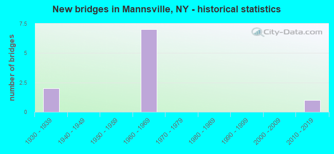
- New bridges - historical statistics
- 21930-1939
- 71960-1969
- 12010-2019

- Reconstructed bridges - Historical Statistics
- 21980-1989
- 11990-1999


- Bridge Condition - Deck
- 16.7%Excellent
- 16.7%Good
- 33.3%Satisfactory
- 16.7%Fair
- 16.7%Poor

- Bridge Condition - Superstructure
- 16.7%Excellent
- 16.7%Satisfactory
- 66.7%Fair

- Bridge Condition - Substructure
- 16.7%Excellent
- 33.3%Satisfactory
- 33.3%Fair
- 16.7%Poor

- Bridge Condition - Channel
- 20.0%Very good
- 60.0%Good
- 20.0%Fair
Find on map >> Show street view
Structure Number: 1008601, Location: 3.7 MI S JCT RTS 193 +I81 (Lat: 43.680953, Lng: -76.072483), Route carried "on" structure: Interstate 81, Year Built: 1961, Year Reconstructed: 1992, Status: Open, Structure Length: 13.62m (44.69ft), Average Daily Traffic: 9,913 (year 2015), Truck Traffic: 25%, Design Load: HS 20, Features Intersected: RTE 11, LINDSEY CREEK
Minimum Vertical Clearance: 30+ m (98+ ft), Kilometerpoint: 1.094, Lanes on structure: 2, Lanes under structure: 2, Base Highway Network: Yes, Owner: State Highway Agency, Approaching Roadway Width: 11.0m (36.1ft), Skew: 3 degrees, Material/Design: Steel, Design/Construction: Stringer/Multi-beam, Number Of Spans In Main Unit: 6, Length of Maximum Span: 34.1m (111.9ft), Curb-To-Curb Width: 9.8m (32.2ft), Out-to-Out Width: 10.7m (35.1ft)
Condition: Deck: Satisfactory, Superstructure: Fair, Substructure: Fair, Channel: Very good, Operating Rating: 65.3 metric tons, Method Used To Determine Operating Rating: Load Factor (LF), Inventory Rating: 39.0 metric tons, Method Used To Determine Inventory Rating: Load Factor (LF), Structural Evaluation: Somewhat better than minimum adequacy, Deck Geometry: Meets minimum limits, Underclear: Meets minimum limits, Waterway Adequacy: High priority of corrective action, Approach Roadway Alignment: Equal to present desirable criteria, Length Of Structure Improvement: 13.62m (44.69ft), Designated Inspection Frequency: Every 24 months, Inspection Date: June 2020, Bridge Improvement Cost: $2,577,000, Roadway Improvement Cost: $1,509,000, Total Project Cost: $4,086,000 ( Estimate for 2021), Deck Structure Type: Concrete Cast-file-Place, Wearing Surface/Protective System: Wearing Surface: Integral Concrete, Deck Protection: Epoxy Coated Reinforcing
Find on map >> Show street view
Structure Number: 1008602, Location: 3.7 MI S JCT RTS 193 +I81 (Lat: 43.681508, Lng: -76.072203), Route carried "on" structure: Interstate 81, Year Built: 1961, Year Reconstructed: 1992, Status: Open, Structure Length: 10.12m (33.20ft), Average Daily Traffic: 4,002 (year 2019), Truck Traffic: 22%, Average Future Daily Traffic: 4,766 (year 2040), Design Load: HS 20, Features Intersected: RTE 11, LINDSEY CREEK
Minimum Vertical Clearance: 30+ m (98+ ft), Kilometerpoint: 1.094, Lanes on structure: 2, Lanes under structure: 2, Base Highway Network: Yes, Owner: State Highway Agency, Approaching Roadway Width: 11.0m (36.1ft), Skew: 3 degrees, Material/Design: Steel, Design/Construction: Stringer/Multi-beam, Number Of Spans In Main Unit: 4, Length of Maximum Span: 34.1m (111.9ft), Curb-To-Curb Width: 9.8m (32.2ft), Out-to-Out Width: 10.7m (35.1ft)
Condition: Deck: Satisfactory, Superstructure: Fair, Substructure: Fair, Channel: Good, Operating Rating: 65.3 metric tons, Method Used To Determine Operating Rating: Load Factor (LF), Inventory Rating: 39.0 metric tons, Method Used To Determine Inventory Rating: Load Factor (LF), Structural Evaluation: Somewhat better than minimum adequacy, Deck Geometry: Meets minimum limits, Underclear: High priority of corrective action, Waterway Adequacy: High priority of corrective action, Approach Roadway Alignment: Equal to present desirable criteria, Length Of Structure Improvement: 10.11m (33.17ft), Designated Inspection Frequency: Every 24 months, Inspection Date: June 2020, Bridge Improvement Cost: $1,950,000, Roadway Improvement Cost: $1,142,000, Total Project Cost: $3,091,000 ( Estimate for 2021), Deck Structure Type: Concrete Cast-file-Place, Wearing Surface/Protective System: Wearing Surface: Integral Concrete, Deck Protection: Epoxy Coated Reinforcing
Find on map >> Show street view
Structure Number: 100861, Location: 1.2 MI N JCT US11 & CO.LN (Lat: 43.686294, Lng: -76.066433), Route carried "on" structure: US 11, Year Built: 1938, Status: Posted for load-capacity, Structure Length: 1.95m (6.40ft), Average Daily Traffic: 1,189 (year 2018), Truck Traffic: 7%, Average Future Daily Traffic: 1,240 (year 2040), Design Load: H 20, Features Intersected: CSX TRANSPRTATION
Minimum Vertical Clearance: 30+ m (98+ ft), Kilometerpoint: 1.802, Lanes on structure: 2, Base Highway Network: Yes, Owner: State Highway Agency, Approaching Roadway Width: 12.2m (40.0ft), Skew: 3 degrees, Material/Design: Steel, Design/Construction: Stringer/Multi-beam, Number Of Spans In Main Unit: 1, Length of Maximum Span: 18.6m (61.0ft), Curb or Sidewalk Widths: Left: 0.6m (2.0ft), Right: 0.6m (2.0ft), Curb-To-Curb Width: 12.2m (40.0ft), Out-to-Out Width: 14.0m (45.9ft)
Condition: Deck: Poor, Superstructure: Fair, Substructure: Satisfactory, Operating Rating: 36.3 metric tons, Method Used To Determine Operating Rating: Allowable Stress (AS), Inventory Rating: 17.2 metric tons, Method Used To Determine Inventory Rating: Allowable Stress (AS), Structural Evaluation: Meets minimum limits, Deck Geometry: Better than present minimum criteria, Underclear: Somewhat better than minimum adequacy, Approach Roadway Alignment: Equal to present desirable criteria, Length Of Structure Improvement: 1.95m (6.40ft), Designated Inspection Frequency: Every 24 months, Inspection Date: June 2021, Bridge Improvement Cost: $1,500,000, Roadway Improvement Cost: $879,000, Total Project Cost: $2,379,000 ( Estimate for 2021), Deck Structure Type: Concrete Cast-file-Place, Wearing Surface/Protective System: Wearing Surface: Bituminous
Find on map >> Show street view
Structure Number: 100862, Location: 2.1 MI N JCT RTE 11 + CL (Lat: 43.710042, Lng: -76.062103), Route carried "on" structure: US 11, Year Built: 1938, Year Reconstructed: 1999, Status: Open, Structure Length: 1.83m (6.00ft), Average Daily Traffic: 1,698 (year 2020), Truck Traffic: 15%, Average Future Daily Traffic: 1,771 (year 2040), Design Load: H 20, Features Intersected: SKINNER CREEK
Minimum Vertical Clearance: 30+ m (98+ ft), Kilometerpoint: 4.537, Lanes on structure: 2, Base Highway Network: Yes, Owner: State Highway Agency, Approaching Roadway Width: 12.3m (40.4ft), Material/Design: Steel, Design/Construction: Stringer/Multi-beam, Number Of Spans In Main Unit: 1, Length of Maximum Span: 17.6m (57.7ft), Curb or Sidewalk Widths: Left: 1.4m (4.6ft), Right: 1.4m (4.6ft), Curb-To-Curb Width: 12.3m (40.4ft), Out-to-Out Width: 16.4m (53.8ft)
Condition: Deck: Good, Superstructure: Satisfactory, Substructure: Satisfactory, Channel: Good, Operating Rating: 68.0 metric tons, Method Used To Determine Operating Rating: Load Factor (LF), Inventory Rating: 38.1 metric tons, Method Used To Determine Inventory Rating: Load Factor (LF), Structural Evaluation: Equal to present minimum criteria, Deck Geometry: Better than present minimum criteria, Waterway Adequacy: Equal to present minimum criteria, Approach Roadway Alignment: Equal to present desirable criteria, Length Of Structure Improvement: 1.82m (5.97ft), Designated Inspection Frequency: Every 24 months, Inspection Date: September 2021, Bridge Improvement Cost: $1,057,000, Roadway Improvement Cost: $619,000, Total Project Cost: $1,676,000 ( Estimate for 2021), Deck Structure Type: Concrete Cast-file-Place, Wearing Surface/Protective System: Wearing Surface: Integral Concrete, Deck Protection: Epoxy Coated Reinforcing
Find on map >> Show street view
Structure Number: 103198, Location: 2.3 MI S JCT 193 + I-81 (Lat: 43.703761, Lng: -76.075442), Route carried "on" structure: Interstate 81, Year Built: 1961, Status: Open, Structure Length: 0.76m (2.49ft), Average Daily Traffic: 8,004 (year 2019), Truck Traffic: 20%, Average Future Daily Traffic: 9,532 (year 2040), Design Load: HS 20, Features Intersected: SKINNER CREEK
Minimum Vertical Clearance: 30+ m (98+ ft), Kilometerpoint: 3.620, Lanes on structure: 4, Base Highway Network: Yes, Owner: State Highway Agency, Approaching Roadway Width: 22.6m (74.1ft), Skew: 20 degrees, Material/Design: Concrete continuous, Design/Construction: Culvert, Number Of Spans In Main Unit: 3, Length of Maximum Span: 2.4m (7.9ft)
Condition: Channel: Fair, Culverts: Good, Structural Evaluation: Better than present minimum criteria, Waterway Adequacy: Superior to present desirable criteria, Approach Roadway Alignment: Equal to present desirable criteria, Length Of Structure Improvement: 0.76m (2.49ft), Designated Inspection Frequency: Every 24 months, Inspection Date: April 2020, Bridge Improvement Cost: $784,000, Roadway Improvement Cost: $459,000, Total Project Cost: $1,243,000 ( Estimate for 2021), Deck Structure Type: Concrete Cast-file-Place, Wearing Surface/Protective System: Wearing Surface: Bituminous
Find on map >> Show street view
Structure Number: 103199, Location: 1.8 MI S JCT 193 + I-81 (Lat: 43.710775, Lng: -76.076083), Route carried "on" structure: County highway , Year Built: 1961, Status: Open, Structure Length: 9.08m (29.79ft), Average Daily Traffic: 403 (year 2015), Truck Traffic: 11%, Average Future Daily Traffic: 564 (year 2035), Design Load: HS 20, Features Intersected: RTE I81, RTE I81, Facility Carried by Structure: COUNTY ROAD 90
Minimum Vertical Clearance: 30+ m (98+ ft), Kilometerpoint: 3.910, Lanes on structure: 2, Lanes under structure: 4, Owner: State Highway Agency, Approaching Roadway Width: 7.3m (24.0ft), Material/Design: Steel, Design/Construction: Stringer/Multi-beam, Number Of Spans In Main Unit: 5, Length of Maximum Span: 22.3m (73.2ft), Curb or Sidewalk Widths: Left: 0.5m (1.6ft), Right: 0.5m (1.6ft), Curb-To-Curb Width: 9.1m (29.9ft), Out-to-Out Width: 10.7m (35.1ft)
Condition: Deck: Fair, Superstructure: Fair, Substructure: Poor, Operating Rating: 45.7 metric tons, Method Used To Determine Operating Rating: Load and Resistance Factor Rating (LRFR) rating reported by rating factor(RF) method using HL-93 loadings, Inventory Rating: 35.3 metric tons, Method Used To Determine Inventory Rating: Load and Resistance Factor Rating (LRFR) rating reported by rating factor(RF) method using HL-93 loadings, Structural Evaluation: Meets minimum limits, Deck Geometry: Equal to present minimum criteria, Underclear: High priority of corrective action, Approach Roadway Alignment: Equal to present desirable criteria, Length Of Structure Improvement: 9.08m (29.79ft), Designated Inspection Frequency: Every 24 months, Inspection Date: May 2020, Bridge Improvement Cost: $1,767,000, Roadway Improvement Cost: $1,035,000, Total Project Cost: $2,802,000 ( Estimate for 2021), Deck Structure Type: Concrete Cast-file-Place, Wearing Surface/Protective System: Wearing Surface: Bituminous, Membrane: Other
Find on map >> Show street view
Structure Number: 333844, Location: 3 MI SE OF ELLISBURG (Lat: 43.696806, Lng: -76.101606), Route carried "on" structure: County highway , Year Built: 2017, Status: Open, Structure Length: 2.23m (7.32ft), Average Daily Traffic: 319 (year 2018), Truck Traffic: 7%, Average Future Daily Traffic: 447 (year 2038), Features Intersected: SKINNER CREEK, Facility Carried by Structure: SANDY CREEK ROAD
Minimum Vertical Clearance: 30+ m (98+ ft), Kilometerpoint: 2.623, Lanes on structure: 2, Owner: County Highway Agency, Approaching Roadway Width: 8.5m (27.9ft), Material/Design: Steel continuous, Design/Construction: Stringer/Multi-beam, Number Of Spans In Main Unit: 1, Length of Maximum Span: 21.0m (68.9ft), Curb-To-Curb Width: 7.9m (25.9ft), Out-to-Out Width: 8.8m (28.9ft)
Condition: Deck: Excellent, Superstructure: Excellent, Substructure: Excellent, Channel: Good, Operating Rating: 98.9 metric tons, Method Used To Determine Operating Rating: Load Factor (LF), Inventory Rating: 59.0 metric tons, Method Used To Determine Inventory Rating: Load Factor (LF), Structural Evaluation: Superior to present desirable criteria, Deck Geometry: Somewhat better than minimum adequacy, Waterway Adequacy: Meets minimum limits, Approach Roadway Alignment: Equal to present desirable criteria, Length Of Structure Improvement: 2.22m (7.28ft), Designated Inspection Frequency: Every 24 months, Inspection Date: November 2021, Bridge Improvement Cost: $457,000, Roadway Improvement Cost: $267,000, Total Project Cost: $724,000 ( Estimate for 2021), Deck Structure Type: Concrete Cast-file-Place, Wearing Surface/Protective System: Wearing Surface: Integral Concrete, Deck Protection: Epoxy Coated Reinforcing
Find on map >> Show street view
Structure Number: 1008601, Location: 3.7 MI S JCT RTS 193 +I81 (Lat: 43.680953, Lng: -76.072483), Route carried "under" structure: US 11, Year Built: 1961, Structure Length: 0. m, Average Daily Traffic: 1,528 (year 1999), Features Intersected: RTE 11, LINDSEY CREEK, Facility Carried by Structure: RTE I81
Minimum Vertical Clearance: 6.19m (20.31ft), Kilometerpoint: 1.014, Lanes on structure: 2, Lanes under structure: 2, Material/Design: Steel, Design/Construction: Stringer/Multi-beam, Length of Maximum Span: 34.1m (111.9ft)
Find on map >> Show street view
Structure Number: 1008602, Location: 3.7 MI S JCT RTS 193 +I81 (Lat: 43.681508, Lng: -76.072203), Route carried "under" structure: US 11, Year Built: 1961, Structure Length: 0. m, Average Daily Traffic: 1,528 (year 1999), Features Intersected: RTE 11, LINDSEY CREEK, Facility Carried by Structure: RTE I81
Minimum Vertical Clearance: 5.84m (19.16ft), Kilometerpoint: 1.094, Lanes on structure: 2, Lanes under structure: 2, Material/Design: Steel, Design/Construction: Stringer/Multi-beam, Length of Maximum Span: 34.1m (111.9ft)
Find on map >> Show street view
Structure Number: 103199, Location: 1.8 MI S JCT 193 + I-81 (Lat: 43.710775, Lng: -76.076083), Route carried "under" structure: Interstate 81, Year Built: 1961, Structure Length: 0. m, Average Daily Traffic: 16,176 (year 1999), Features Intersected: RTE I81, RTE I81, Facility Carried by Structure: COUNTY ROAD 90
Minimum Vertical Clearance: 5.00m (16.40ft), Kilometerpoint: 4.425, Lanes on structure: 2, Lanes under structure: 2, Material/Design: Steel, Design/Construction: Stringer/Multi-beam, Length of Maximum Span: 22.3m (73.2ft)