Bridge Statistics for Manorville, New York (NY)
Condition, Traffic, Stress, Structural Evaluation, Project Costs
- National Bridge Inventory (NBI) Statistics
- 23Number of bridges
- 272ft / 83.0mTotal length
- $77,542,000Total costs
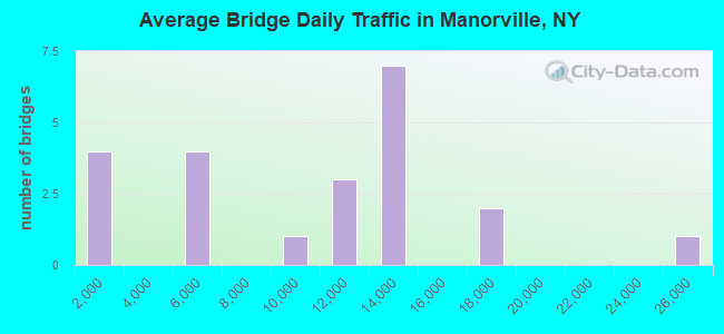
- 212,654Total average daily traffic
- 7,289Total average daily truck traffic
- National Bridge Inventory (NBI) Registered Bridges for Manorville
- No street view available for this location
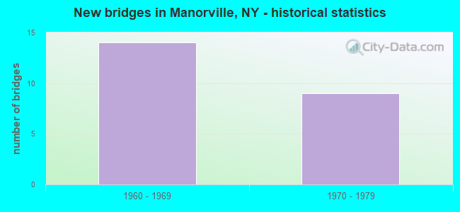
- New bridges - historical statistics
- 141960-1969
- 91970-1979
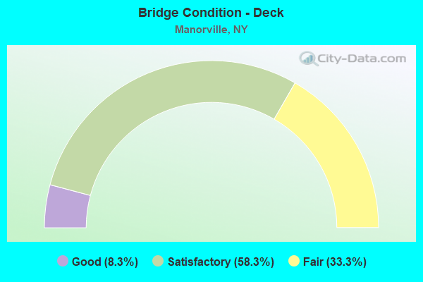
- Bridge Condition - Deck
- 8.3%Good
- 58.3%Satisfactory
- 33.3%Fair
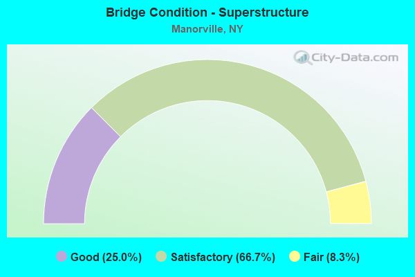
- Bridge Condition - Superstructure
- 25.0%Good
- 66.7%Satisfactory
- 8.3%Fair
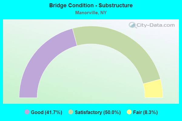
- Bridge Condition - Substructure
- 41.7%Good
- 50.0%Satisfactory
- 8.3%Fair
Find on map >> Show street view
Structure Number: 101936, Location: .4 MI W EXIT 59 OF S.H.27 (Lat: 40.822267, Lng: -72.820217), Route carried "on" structure: Other road , Year Built: 1963, Status: Open, Structure Length: 7.07m (23.20ft), Average Daily Traffic: 5,909 (year 2018), Truck Traffic: 5%, Average Future Daily Traffic: 7,178 (year 2040), Design Load: HS 20, Features Intersected: 27 27 07051338, W/B, RTE, Facility Carried by Structure: MORICHES M.I.ROAD
Minimum Vertical Clearance: 30+ m (98+ ft), Kilometerpoint: 8.656, Lanes on structure: 2, Lanes under structure: 4, Owner: State Highway Agency, Approaching Roadway Width: 8.5m (27.9ft), Skew: 2 degrees, Material/Design: Steel, Design/Construction: Stringer/Multi-beam, Number Of Spans In Main Unit: 4, Length of Maximum Span: 22.9m (75.1ft), Curb or Sidewalk Widths: Left: 1.2m (3.9ft), Right: 1.2m (3.9ft), Curb-To-Curb Width: 8.5m (27.9ft), Out-to-Out Width: 11.6m (38.1ft)
Condition: Deck: Satisfactory, Superstructure: Satisfactory, Substructure: Good, Operating Rating: 59.9 metric tons, Method Used To Determine Operating Rating: Load Factor (LF), Inventory Rating: 35.4 metric tons, Method Used To Determine Inventory Rating: Load Factor (LF), Structural Evaluation: Equal to present minimum criteria, Deck Geometry: Meets minimum limits, Underclear: High priority of corrective action, Approach Roadway Alignment: Better than present minimum criteria, Length Of Structure Improvement: 7.07m (23.20ft), Designated Inspection Frequency: Every 24 months, Inspection Date: September 2021, Bridge Improvement Cost: $3,089,000, Roadway Improvement Cost: $1,809,000, Total Project Cost: $4,898,000 ( Estimate for 2021), Deck Structure Type: Concrete Cast-file-Place, Wearing Surface/Protective System: Wearing Surface: Integral Concrete
Find on map >> Show street view
Structure Number: 101937, Location: IN BROOKHAVEN (Lat: 40.822939, Lng: -72.808956), Route carried "on" structure: County highway , Year Built: 1963, Status: Open, Structure Length: 7.32m (24.02ft), Average Daily Traffic: 8,819 (year 2020), Truck Traffic: 7%, Average Future Daily Traffic: 10,713 (year 2040), Design Load: HS 20, Features Intersected: 27 27 07051345, RTE 27, Facility Carried by Structure: WADING RIVER RD
Minimum Vertical Clearance: 30+ m (98+ ft), Kilometerpoint: 2.092, Lanes on structure: 4, Lanes under structure: 4, Owner: State Highway Agency, Approaching Roadway Width: 17.1m (56.1ft), Skew: 21 degrees, Material/Design: Steel, Design/Construction: Stringer/Multi-beam, Number Of Spans In Main Unit: 4, Length of Maximum Span: 21.6m (70.9ft), Curb or Sidewalk Widths: Left: 1.2m (3.9ft), Right: 1.2m (3.9ft), Curb-To-Curb Width: 17.1m (56.1ft), Out-to-Out Width: 20.1m (65.9ft)
Condition: Deck: Satisfactory, Superstructure: Satisfactory, Substructure: Good, Operating Rating: 52.2 metric tons, Method Used To Determine Operating Rating: Load and Resistance Factor Rating (LRFR) rating reported by rating factor(RF) method using HL-93 loadings, Inventory Rating: 40.2 metric tons, Method Used To Determine Inventory Rating: Load and Resistance Factor Rating (LRFR) rating reported by rating factor(RF) method using HL-93 loadings, Structural Evaluation: Equal to present minimum criteria, Deck Geometry: Somewhat better than minimum adequacy, Underclear: High priority of corrective action, Approach Roadway Alignment: Equal to present minimum criteria, Length Of Structure Improvement: 7.31m (23.98ft), Designated Inspection Frequency: Every 24 months, Inspection Date: September 2020, Bridge Improvement Cost: $5,587,000, Roadway Improvement Cost: $3,272,000, Total Project Cost: $8,859,000 ( Estimate for 2021), Deck Structure Type: Concrete Cast-file-Place, Wearing Surface/Protective System: Wearing Surface: Integral Concrete
Find on map >> Show street view
Structure Number: 101938, Location: SH 27-EXIT 60-BROOKHAVEN (Lat: 40.823558, Lng: -72.792403), Route carried "on" structure: Other road , Year Built: 1963, Status: Open, Structure Length: 6.61m (21.69ft), Average Daily Traffic: 5,787 (year 2020), Truck Traffic: 5%, Average Future Daily Traffic: 7,030 (year 2040), Design Load: HS 20, Features Intersected: 27 27 07051353, RTE 27, Facility Carried by Structure: RAILROAD AVE
Minimum Vertical Clearance: 30+ m (98+ ft), Kilometerpoint: 2.590, Lanes on structure: 2, Lanes under structure: 4, Owner: State Highway Agency, Approaching Roadway Width: 8.5m (27.9ft), Material/Design: Steel, Design/Construction: Stringer/Multi-beam, Number Of Spans In Main Unit: 4, Length of Maximum Span: 20.7m (67.9ft), Curb or Sidewalk Widths: Left: 1.0m (3.3ft), Right: 1.0m (3.3ft), Curb-To-Curb Width: 8.5m (27.9ft), Out-to-Out Width: 11.6m (38.1ft)
Condition: Deck: Satisfactory, Superstructure: Good, Substructure: Satisfactory, Operating Rating: 61.7 metric tons, Method Used To Determine Operating Rating: Load Factor (LF), Inventory Rating: 36.3 metric tons, Method Used To Determine Inventory Rating: Load Factor (LF), Structural Evaluation: Equal to present minimum criteria, Deck Geometry: Meets minimum limits, Underclear: Somewhat better than minimum adequacy, Approach Roadway Alignment: Equal to present desirable criteria, Length Of Structure Improvement: 6.61m (21.69ft), Designated Inspection Frequency: Every 24 months, Inspection Date: September 2020, Bridge Improvement Cost: $2,921,000, Roadway Improvement Cost: $1,710,000, Total Project Cost: $4,631,000 ( Estimate for 2021), Deck Structure Type: Concrete Cast-file-Place, Wearing Surface/Protective System: Wearing Surface: Integral Concrete
Find on map >> Show street view
Structure Number: 101939, Location: 1 MI E EXIT 60 OF SH 27 (Lat: 40.826253, Lng: -72.773119), Route carried "on" structure: Other road , Year Built: 1963, Status: Open, Structure Length: 6.80m (22.31ft), Average Daily Traffic: 1,578 (year 2020), Truck Traffic: 7%, Average Future Daily Traffic: 2,209 (year 2040), Design Load: HS 20+Mod, Features Intersected: 27 27 07051364 - EB Roa, Facility Carried by Structure: CHAPMAN BLVD
Minimum Vertical Clearance: 30+ m (98+ ft), Kilometerpoint: 1.335, Lanes on structure: 2, Lanes under structure: 4, Owner: State Highway Agency, Approaching Roadway Width: 12.2m (40.0ft), Skew: 1 degrees, Material/Design: Steel, Design/Construction: Stringer/Multi-beam, Number Of Spans In Main Unit: 4, Length of Maximum Span: 21.4m (70.2ft), Curb or Sidewalk Widths: Left: 1.2m (3.9ft), Right: 1.2m (3.9ft), Curb-To-Curb Width: 8.5m (27.9ft), Out-to-Out Width: 11.6m (38.1ft)
Condition: Deck: Satisfactory, Superstructure: Good, Substructure: Good, Operating Rating: 56.2 metric tons, Method Used To Determine Operating Rating: Load Factor (LF), Inventory Rating: 33.6 metric tons, Method Used To Determine Inventory Rating: Load Factor (LF), Structural Evaluation: Better than present minimum criteria, Deck Geometry: Somewhat better than minimum adequacy, Underclear: Meets minimum limits, Approach Roadway Alignment: Better than present minimum criteria, Length Of Structure Improvement: 6.79m (22.28ft), Designated Inspection Frequency: Every 24 months, Inspection Date: October 2020, Bridge Improvement Cost: $3,013,000, Roadway Improvement Cost: $1,764,000, Total Project Cost: $4,777,000 ( Estimate for 2021), Deck Structure Type: Concrete Cast-file-Place, Wearing Surface/Protective System: Wearing Surface: Integral Concrete
Find on map >> Show street view
Structure Number: 105326, Location: 1 MI E OF EXIT 70 - I495 (Lat: 40.877514, Lng: -72.781017), Route carried "on" structure: Other road , Year Built: 1969, Status: Open, Structure Length: 6.95m (22.80ft), Average Daily Traffic: 589 (year 2020), Truck Traffic: 9%, Average Future Daily Traffic: 728 (year 2040), Design Load: HS 20, Features Intersected: 495I495I07031359, RTE I4, Facility Carried by Structure: HALSEY MANOR ROAD
Minimum Vertical Clearance: 30+ m (98+ ft), Kilometerpoint: 1.947, Lanes on structure: 2, Lanes under structure: 6, Owner: State Highway Agency, Approaching Roadway Width: 8.5m (27.9ft), Skew: 1 degrees, Material/Design: Steel, Design/Construction: Stringer/Multi-beam, Number Of Spans In Main Unit: 4, Length of Maximum Span: 24.0m (78.7ft), Curb or Sidewalk Widths: Left: 1.5m (4.9ft), Right: 1.5m (4.9ft), Curb-To-Curb Width: 8.5m (27.9ft), Out-to-Out Width: 12.3m (40.4ft)
Condition: Deck: Fair, Superstructure: Satisfactory, Substructure: Satisfactory, Operating Rating: 63.5 metric tons, Method Used To Determine Operating Rating: Load Factor (LF), Inventory Rating: 38.1 metric tons, Method Used To Determine Inventory Rating: Load Factor (LF), Structural Evaluation: Equal to present minimum criteria, Deck Geometry: Somewhat better than minimum adequacy, Underclear: High priority of corrective action, Approach Roadway Alignment: Equal to present desirable criteria, Length Of Structure Improvement: 6.94m (22.77ft), Designated Inspection Frequency: Every 24 months, Inspection Date: September 2020, Bridge Improvement Cost: $3,253,000, Roadway Improvement Cost: $1,905,000, Total Project Cost: $5,159,000 ( Estimate for 2021), Deck Structure Type: Concrete Cast-file-Place, Wearing Surface/Protective System: Wearing Surface: Integral Concrete
Find on map >> Show street view
Structure Number: 1053271, Location: RTE 495+RTE 24 (Lat: 40.903769, Lng: -72.740967), Route carried "on" structure: Interstate 495, Year Built: 1969, Status: Open, Structure Length: 4.72m (15.49ft), Average Daily Traffic: 10,314 (year 2018), Truck Traffic: 5%, Average Future Daily Traffic: 10,829 (year 2040), Design Load: HS 20, Features Intersected: EDWARDS AVE N/B, EDWARDS
Minimum Vertical Clearance: 30+ m (98+ ft), Kilometerpoint: 62.719, Lanes on structure: 3, Lanes under structure: 5, Base Highway Network: Yes, Owner: State Highway Agency, Approaching Roadway Width: 12.2m (40.0ft), Material/Design: Steel, Design/Construction: Stringer/Multi-beam, Number Of Spans In Main Unit: 3, Length of Maximum Span: 25.6m (84.0ft), Curb or Sidewalk Widths: Left: 0.8m (2.6ft), Right: 0.5m (1.6ft), Curb-To-Curb Width: 12.2m (40.0ft), Out-to-Out Width: 14.0m (45.9ft)
Condition: Deck: Fair, Superstructure: Satisfactory, Substructure: Satisfactory, Operating Rating: 63.5 metric tons, Method Used To Determine Operating Rating: Load Factor (LF), Inventory Rating: 38.1 metric tons, Method Used To Determine Inventory Rating: Load Factor (LF), Structural Evaluation: Equal to present minimum criteria, Deck Geometry: High priority of replacement, Underclear: High priority of corrective action, Approach Roadway Alignment: Equal to present desirable criteria, Length Of Structure Improvement: 4.72m (15.49ft), Designated Inspection Frequency: Every 24 months, Inspection Date: October 2021, Bridge Improvement Cost: $2,597,000, Roadway Improvement Cost: $1,521,000, Total Project Cost: $4,117,000 ( Estimate for 2021), Deck Structure Type: Concrete Cast-file-Place, Wearing Surface/Protective System: Wearing Surface: Monolithic Concrete
Find on map >> Show street view
Structure Number: 1053272, Location: RTE 495+RTE 24 (Lat: 40.903558, Lng: -72.740725), Route carried "on" structure: Interstate 495, Year Built: 1969, Status: Open, Structure Length: 4.72m (15.49ft), Average Daily Traffic: 10,314 (year 2018), Truck Traffic: 5%, Average Future Daily Traffic: 10,829 (year 2040), Design Load: HS 20, Features Intersected: EDWARDS AVE NB, EDWARDS
Minimum Vertical Clearance: 30+ m (98+ ft), Kilometerpoint: 62.719, Lanes on structure: 3, Lanes under structure: 5, Base Highway Network: Yes, Owner: State Highway Agency, Approaching Roadway Width: 13.1m (43.0ft), Material/Design: Steel, Design/Construction: Stringer/Multi-beam, Number Of Spans In Main Unit: 3, Length of Maximum Span: 25.6m (84.0ft), Curb-To-Curb Width: 13.0m (42.7ft), Out-to-Out Width: 14.0m (45.9ft)
Condition: Deck: Fair, Superstructure: Satisfactory, Substructure: Satisfactory, Operating Rating: 64.4 metric tons, Method Used To Determine Operating Rating: Load Factor (LF), Inventory Rating: 39.0 metric tons, Method Used To Determine Inventory Rating: Load Factor (LF), Structural Evaluation: Equal to present minimum criteria, Deck Geometry: High priority of replacement, Underclear: High priority of corrective action, Approach Roadway Alignment: Equal to present desirable criteria, Length Of Structure Improvement: 4.72m (15.49ft), Designated Inspection Frequency: Every 24 months, Inspection Date: October 2021, Bridge Improvement Cost: $2,538,000, Roadway Improvement Cost: $1,486,000, Total Project Cost: $4,024,000 ( Estimate for 2021), Deck Structure Type: Concrete Cast-file-Place, Wearing Surface/Protective System: Wearing Surface: Monolithic Concrete
Find on map >> Show street view
Structure Number: 1064201, Location: EAST OF EXIT 68 - I495 (Lat: 40.851158, Lng: -72.860231), Route carried "on" structure: Interstate 495, Year Built: 1970, Status: Open, Structure Length: 8.14m (26.71ft), Average Daily Traffic: 25,630 (year 2009), Truck Traffic: 13%, Design Load: HS 20, Features Intersected: LONG ISLAND- MAIN
Minimum Vertical Clearance: 30+ m (98+ ft), Kilometerpoint: 50.571, Lanes on structure: 3, Base Highway Network: Yes, Owner: State Highway Agency, Approaching Roadway Width: 12.2m (40.0ft), Skew: 6 degrees, Material/Design: Steel, Design/Construction: Stringer/Multi-beam, Number Of Spans In Main Unit: 3, Length of Maximum Span: 25.9m (85.0ft), Curb or Sidewalk Widths: Left: 0.4m (1.3ft), Right: 0.4m (1.3ft), Curb-To-Curb Width: 12.2m (40.0ft), Out-to-Out Width: 13.7m (44.9ft)
Condition: Deck: Satisfactory, Superstructure: Satisfactory, Substructure: Satisfactory, Operating Rating: 50.8 metric tons, Method Used To Determine Operating Rating: Load Factor (LF), Inventory Rating: 30.8 metric tons, Method Used To Determine Inventory Rating: Load Factor (LF), Structural Evaluation: Equal to present minimum criteria, Deck Geometry: High priority of corrective action, Underclear: Somewhat better than minimum adequacy, Approach Roadway Alignment: Equal to present desirable criteria, Length Of Structure Improvement: 8.13m (26.67ft), Designated Inspection Frequency: Every 24 months, Inspection Date: September 2021, Bridge Improvement Cost: $4,810,000, Roadway Improvement Cost: $2,817,000, Total Project Cost: $7,626,000 ( Estimate for 2021), Deck Structure Type: Concrete Cast-file-Place, Wearing Surface/Protective System: Wearing Surface: Monolithic Concrete
Find on map >> Show street view
Structure Number: 106421, Location: 7.3 MI E RTS 112+495 (Lat: 40.854658, Lng: -72.843322), Route carried "on" structure: Other road , Year Built: 1970, Status: Open, Structure Length: 7.10m (23.29ft), Average Daily Traffic: 682 (year 2018), Truck Traffic: 6%, Average Future Daily Traffic: 843 (year 2040), Design Load: HS 20, Features Intersected: 495I 495I 07031322 WB, R, Facility Carried by Structure: WEEKS AVENUE
Minimum Vertical Clearance: 30+ m (98+ ft), Kilometerpoint: 3.572, Lanes on structure: 2, Lanes under structure: 9, Owner: State Highway Agency, Approaching Roadway Width: 13.4m (44.0ft), Material/Design: Steel, Design/Construction: Stringer/Multi-beam, Number Of Spans In Main Unit: 4, Length of Maximum Span: 23.7m (77.8ft), Curb or Sidewalk Widths: Left: 1.5m (4.9ft), Right: 1.5m (4.9ft), Curb-To-Curb Width: 8.5m (27.9ft), Out-to-Out Width: 12.2m (40.0ft)
Condition: Deck: Satisfactory, Superstructure: Good, Substructure: Satisfactory, Operating Rating: 57.2 metric tons, Method Used To Determine Operating Rating: Load Factor (LF), Inventory Rating: 34.5 metric tons, Method Used To Determine Inventory Rating: Load Factor (LF), Structural Evaluation: Equal to present minimum criteria, Deck Geometry: Somewhat better than minimum adequacy, Underclear: High priority of corrective action, Approach Roadway Alignment: Equal to present desirable criteria, Length Of Structure Improvement: 7.10m (23.29ft), Designated Inspection Frequency: Every 24 months, Inspection Date: November 2020, Bridge Improvement Cost: $3,278,000, Roadway Improvement Cost: $1,920,000, Total Project Cost: $5,198,000 ( Estimate for 2021), Deck Structure Type: Concrete Cast-file-Place, Wearing Surface/Protective System: Wearing Surface: Integral Concrete
Find on map >> Show street view
Structure Number: 1064229, Location: 8.8 MI E JCT SH112 & I495 (Lat: 40.863269, Lng: -72.822283), Route carried "on" structure: Other road , Year Built: 1970, Status: Open, Structure Length: 7.01m (23.00ft), Average Daily Traffic: 10,458 (year 2018), Truck Traffic: 6%, Average Future Daily Traffic: 12,704 (year 2040), Design Load: HS 20, Features Intersected: 495I495I07041336 E/B, RT, Facility Carried by Structure: WADING RIVER ROAD
Minimum Vertical Clearance: 30+ m (98+ ft), Kilometerpoint: 6.790, Lanes on structure: 2, Lanes under structure: 6, Owner: State Highway Agency, Approaching Roadway Width: 15.2m (49.9ft), Skew: 20 degrees, Material/Design: Steel, Design/Construction: Stringer/Multi-beam, Number Of Spans In Main Unit: 4, Length of Maximum Span: 23.7m (77.8ft), Curb or Sidewalk Widths: Left: 1.5m (4.9ft), Right: 1.5m (4.9ft), Curb-To-Curb Width: 15.2m (49.9ft), Out-to-Out Width: 23.2m (76.1ft)
Condition: Deck: Satisfactory, Superstructure: Satisfactory, Substructure: Good, Operating Rating: 37.9 metric tons, Method Used To Determine Operating Rating: Load and Resistance Factor Rating (LRFR) rating reported by rating factor(RF) method using HL-93 loadings, Inventory Rating: 29.2 metric tons, Method Used To Determine Inventory Rating: Load and Resistance Factor Rating (LRFR) rating reported by rating factor(RF) method using HL-93 loadings, Structural Evaluation: Equal to present minimum criteria, Deck Geometry: Superior to present desirable criteria, Underclear: High priority of corrective action, Approach Roadway Alignment: Equal to present desirable criteria, Length Of Structure Improvement: 7.01m (23.00ft), Designated Inspection Frequency: Every 24 months, Inspection Date: October 2021, Bridge Improvement Cost: $6,156,000, Roadway Improvement Cost: $3,605,000, Total Project Cost: $9,761,000 ( Estimate for 2021), Deck Structure Type: Concrete Cast-file-Place, Wearing Surface/Protective System: Wearing Surface: Integral Concrete
Find on map >> Show street view
Structure Number: 106423, Location: 9.5 MI E RTS 112+495 (Lat: 40.868275, Lng: -72.809494), Route carried "on" structure: Other road , Year Built: 1970, Status: Open, Structure Length: 7.74m (25.39ft), Average Daily Traffic: 937 (year 2018), Truck Traffic: 5%, Average Future Daily Traffic: 1,312 (year 2038), Design Load: HS 20, Features Intersected: 495I 495I 0704 1342 WB,, Facility Carried by Structure: RYERSON AVE
Minimum Vertical Clearance: 30+ m (98+ ft), Kilometerpoint: 1.770, Lanes on structure: 2, Lanes under structure: 6, Owner: State Highway Agency, Approaching Roadway Width: 13.4m (44.0ft), Skew: 2 degrees, Material/Design: Steel, Design/Construction: Stringer/Multi-beam, Number Of Spans In Main Unit: 4, Length of Maximum Span: 26.2m (86.0ft), Curb or Sidewalk Widths: Left: 1.5m (4.9ft), Right: 1.5m (4.9ft), Curb-To-Curb Width: 8.5m (27.9ft), Out-to-Out Width: 12.2m (40.0ft)
Condition: Deck: Good, Superstructure: Satisfactory, Substructure: Good, Operating Rating: 58.1 metric tons, Method Used To Determine Operating Rating: Load Factor (LF), Inventory Rating: 34.5 metric tons, Method Used To Determine Inventory Rating: Load Factor (LF), Structural Evaluation: Equal to present minimum criteria, Deck Geometry: Somewhat better than minimum adequacy, Underclear: High priority of corrective action, Approach Roadway Alignment: Equal to present desirable criteria, Length Of Structure Improvement: 7.74m (25.39ft), Designated Inspection Frequency: Every 24 months, Inspection Date: November 2021, Bridge Improvement Cost: $3,578,000, Roadway Improvement Cost: $2,095,000, Total Project Cost: $5,673,000 ( Estimate for 2021), Deck Structure Type: Concrete Cast-file-Place, Wearing Surface/Protective System: Wearing Surface: Monolithic Concrete
Find on map >> Show street view
Structure Number: 1064249, Location: EXIT 70 OF I495 (Lat: 40.871753, Lng: -72.802211), Route carried "on" structure: County highway , Year Built: 1970, Status: Open, Structure Length: 8.87m (29.10ft), Average Daily Traffic: 17,037 (year 2020), Truck Traffic: 5%, Average Future Daily Traffic: 20,265 (year 2040), Design Load: HS 20, Features Intersected: 495I 495I 07041347 WB, R, Facility Carried by Structure: COUNTY ROUTE 111
Minimum Vertical Clearance: 30+ m (98+ ft), Kilometerpoint: 7.514, Lanes on structure: 5, Lanes under structure: 6, Owner: State Highway Agency, Approaching Roadway Width: 15.2m (49.9ft), Skew: 3 degrees, Material/Design: Steel, Design/Construction: Stringer/Multi-beam, Number Of Spans In Main Unit: 4, Length of Maximum Span: 29.5m (96.8ft), Curb or Sidewalk Widths: Left: 1.5m (4.9ft), Right: 1.5m (4.9ft), Curb-To-Curb Width: 15.2m (49.9ft), Out-to-Out Width: 23.2m (76.1ft)
Condition: Deck: Fair, Superstructure: Fair, Substructure: Fair, Operating Rating: 58.1 metric tons, Method Used To Determine Operating Rating: Load Factor (LF), Inventory Rating: 34.5 metric tons, Method Used To Determine Inventory Rating: Load Factor (LF), Structural Evaluation: Somewhat better than minimum adequacy, Deck Geometry: High priority of replacement, Underclear: High priority of corrective action, Approach Roadway Alignment: Equal to present desirable criteria, Length Of Structure Improvement: 8.86m (29.07ft), Designated Inspection Frequency: Every 24 months, Inspection Date: November 2021, Bridge Improvement Cost: $8,084,000, Roadway Improvement Cost: $4,734,000, Total Project Cost: $12,819,000 ( Estimate for 2021), Deck Structure Type: Concrete Cast-file-Place, Wearing Surface/Protective System: Wearing Surface: Bituminous, Membrane: Preformed Fabric
Find on map >> Show street view
Structure Number: 101936, Location: .4 MI W EXIT 59 OF S.H.27 (Lat: 40.822267, Lng: -72.820217), Route carried "under" structure: State highway 27, Year Built: 1963, Structure Length: 0. m, Features Intersected: 27 27 07051338, W/B, RTE, Facility Carried by Structure: MORICHES M.I.ROAD
Minimum Vertical Clearance: 4.75m (15.58ft), Kilometerpoint: 54.384, Lanes on structure: 2, Lanes under structure: 2, Material/Design: Steel, Design/Construction: Stringer/Multi-beam, Length of Maximum Span: 22.9m (75.1ft)
Find on map >> Show street view
Structure Number: 101937, Location: IN BROOKHAVEN (Lat: 40.822939, Lng: -72.808956), Route carried "under" structure: State highway 27, Year Built: 1963, Structure Length: 0. m, Average Daily Traffic: 16,200 (year 1973), Features Intersected: 27 27 07051345, RTE 27, Facility Carried by Structure: WADING RIVER RD
Minimum Vertical Clearance: 4.39m (14.40ft), Kilometerpoint: 55.462, Lanes on structure: 4, Lanes under structure: 2, Material/Design: Steel, Design/Construction: Stringer/Multi-beam, Length of Maximum Span: 21.6m (70.9ft)
Find on map >> Show street view
Structure Number: 101938, Location: SH 27-EXIT 60-BROOKHAVEN (Lat: 40.823558, Lng: -72.792403), Route carried "under" structure: State highway 27, Year Built: 1963, Structure Length: 0. m, Average Daily Traffic: 13,800 (year 1973), Features Intersected: 27 27 07051353, RTE 27, Facility Carried by Structure: RAILROAD AVE
Minimum Vertical Clearance: 4.93m (16.17ft), Kilometerpoint: 56.749, Lanes on structure: 2, Lanes under structure: 2, Material/Design: Steel, Design/Construction: Stringer/Multi-beam, Length of Maximum Span: 20.7m (67.9ft)
Find on map >> Show street view
Structure Number: 101939, Location: 1 MI E EXIT 60 OF SH 27 (Lat: 40.826253, Lng: -72.773119), Route carried "under" structure: State highway 27, Year Built: 1963, Structure Length: 0. m, Average Daily Traffic: 12,000 (year 1973), Features Intersected: 27 27 07051364 - EB Roa, Facility Carried by Structure: CHAPMAN BLVD
Minimum Vertical Clearance: 4.78m (15.68ft), Kilometerpoint: 58.423, Lanes on structure: 2, Lanes under structure: 2, Material/Design: Steel, Design/Construction: Stringer/Multi-beam, Length of Maximum Span: 21.4m (70.2ft)
Find on map >> Show street view
Structure Number: 105326, Location: 1 MI E OF EXIT 70 - I495 (Lat: 40.877514, Lng: -72.781017), Route carried "under" structure: Interstate 495, Year Built: 1969, Structure Length: 0. m, Average Daily Traffic: 12,000 (year 1973), Features Intersected: 495I495I07031359, RTE I4, Facility Carried by Structure: HALSEY MANOR ROAD
Minimum Vertical Clearance: 4.57m (14.99ft), Kilometerpoint: 57.731, Lanes on structure: 2, Lanes under structure: 3, Material/Design: Steel, Design/Construction: Stringer/Multi-beam, Length of Maximum Span: 24.0m (78.7ft)
Find on map >> Show street view
Structure Number: 1053271, Location: RTE 495+RTE 24 (Lat: 40.903769, Lng: -72.740967), Route carried "under" structure: County highway , Year Built: 1969, Structure Length: 0. m, Average Daily Traffic: 4,500 (year 2021), Features Intersected: EDWARDS AVE N/B, EDWARDS, Facility Carried by Structure: RTE I495
Minimum Vertical Clearance: 4.80m (15.75ft), Kilometerpoint: 0.000, Lanes on structure: 3, Lanes under structure: 2, Material/Design: Steel, Design/Construction: Stringer/Multi-beam, Length of Maximum Span: 25.6m (84.0ft)
Find on map >> Show street view
Structure Number: 1053272, Location: RTE 495+RTE 24 (Lat: 40.903558, Lng: -72.740725), Route carried "under" structure: County highway , Year Built: 1969, Structure Length: 0. m, Average Daily Traffic: 4,500 (year 2021), Features Intersected: EDWARDS AVE NB, EDWARDS, Facility Carried by Structure: RTE I495
Minimum Vertical Clearance: 4.45m (14.60ft), Kilometerpoint: 0.000, Lanes on structure: 3, Lanes under structure: 2, Material/Design: Steel, Design/Construction: Stringer/Multi-beam, Length of Maximum Span: 25.6m (84.0ft)
Find on map >> Show street view
Structure Number: 106421, Location: 7.3 MI E RTS 112+495 (Lat: 40.854658, Lng: -72.843322), Route carried "under" structure: Interstate 495, Year Built: 1970, Structure Length: 0. m, Average Daily Traffic: 13,800 (year 1973), Features Intersected: 495I 495I 07031322 WB, R, Facility Carried by Structure: WEEKS AVENUE
Minimum Vertical Clearance: 4.60m (15.09ft), Kilometerpoint: 52.196, Lanes on structure: 2, Lanes under structure: 6, Material/Design: Steel, Design/Construction: Stringer/Multi-beam, Length of Maximum Span: 23.7m (77.8ft)
Find on map >> Show street view
Structure Number: 1064229, Location: 8.8 MI E JCT SH112 & I495 (Lat: 40.863269, Lng: -72.822283), Route carried "under" structure: Interstate 495, Year Built: 1970, Structure Length: 0. m, Average Daily Traffic: 13,800 (year 1973), Features Intersected: 495I495I07041336 E/B, RT, Facility Carried by Structure: WADING RIVER ROAD
Minimum Vertical Clearance: 4.57m (14.99ft), Kilometerpoint: 54.368, Lanes on structure: 2, Lanes under structure: 3, Material/Design: Steel, Design/Construction: Stringer/Multi-beam, Length of Maximum Span: 23.7m (77.8ft)
Find on map >> Show street view
Structure Number: 106423, Location: 9.5 MI E RTS 112+495 (Lat: 40.868275, Lng: -72.809494), Route carried "under" structure: Interstate 495, Year Built: 1970, Structure Length: 0. m, Average Daily Traffic: 12,000 (year 1973), Features Intersected: 495I 495I 0704 1342 WB,, Facility Carried by Structure: RYERSON AVE
Minimum Vertical Clearance: 4.50m (14.76ft), Kilometerpoint: 55.430, Lanes on structure: 2, Lanes under structure: 3, Material/Design: Steel, Design/Construction: Stringer/Multi-beam, Length of Maximum Span: 26.2m (86.0ft)
Find on map >> Show street view
Structure Number: 1064249, Location: EXIT 70 OF I495 (Lat: 40.871753, Lng: -72.802211), Route carried "under" structure: Interstate 495, Year Built: 1970, Structure Length: 0. m, Average Daily Traffic: 12,000 (year 1973), Features Intersected: 495I 495I 07041347 WB, R, Facility Carried by Structure: COUNTY ROUTE 111
Minimum Vertical Clearance: 4.70m (15.42ft), Kilometerpoint: 56.154, Lanes on structure: 5, Lanes under structure: 3, Material/Design: Steel, Design/Construction: Stringer/Multi-beam, Length of Maximum Span: 29.5m (96.8ft)