Bridge Statistics for Marathon, New York (NY)
Condition, Traffic, Stress, Structural Evaluation, Project Costs
- National Bridge Inventory (NBI) Statistics
- 25Number of bridges
- 171ft / 51.9mTotal length
- $35,454,000Total costs
- 64,202Total average daily traffic
- 14,779Total average daily truck traffic
- National Bridge Inventory (NBI) Registered Bridges for Marathon
- No street view available for this location
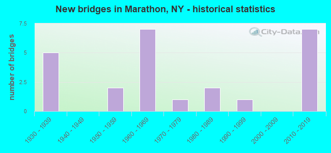
- New bridges - historical statistics
- 51930-1939
- 21950-1959
- 71960-1969
- 11970-1979
- 21980-1989
- 11990-1999
- 72010-2019

- Reconstructed bridges - Historical Statistics
- 21980-1989
- 11990-1999


- Bridge Condition - Deck
- 7.7%Excellent
- 23.1%Very good
- 30.8%Good
- 15.4%Satisfactory
- 15.4%Fair
- 7.7%Poor

- Bridge Condition - Superstructure
- 6.3%Excellent
- 25.0%Very good
- 18.8%Good
- 18.8%Satisfactory
- 6.3%Fair
- 25.0%Poor

- Bridge Condition - Substructure
- 6.3%Excellent
- 18.8%Very good
- 31.3%Good
- 18.8%Satisfactory
- 25.0%Fair

- Bridge Condition - Channel
- 5.9%Very good
- 23.5%Good
- 35.3%Satisfactory
- 17.6%Fair
- 11.8%Poor
- 5.9%Serious

- Bridge Condition - Culverts
- 20.0%Very good
- 60.0%Satisfactory
- 20.0%Poor
Find on map >> Show street view
Structure Number: 100834, Location: 0.1 MI N JCT RTS 11 & 221 (Lat: 42.442242, Lng: -76.032833), Route carried "on" structure: US 11, Year Built: 1999, Status: Open, Structure Length: 2.13m (6.99ft), Average Daily Traffic: 1,877 (year 2020), Truck Traffic: 6%, Average Future Daily Traffic: 2,624 (year 2040), Design Load: HS 25 or greater, Features Intersected: HUNTS CREEK
Minimum Vertical Clearance: 30+ m (98+ ft), Kilometerpoint: 3.942, Lanes on structure: 2, Base Highway Network: Yes, Owner: State Highway Agency, Approaching Roadway Width: 12.2m (40.0ft), Skew: 1 degrees, Material/Design: Prestressed concrete, Design/Construction: Box Beam or Girders - Multiple, Number Of Spans In Main Unit: 1, Length of Maximum Span: 20.4m (66.9ft), Curb or Sidewalk Widths: Left: 2.5m (8.2ft), Right: 2.5m (8.2ft), Curb-To-Curb Width: 12.2m (40.0ft), Out-to-Out Width: 18.2m (59.7ft)
Condition: Deck: Good, Superstructure: Very good, Substructure: Good, Channel: Good, Operating Rating: 74.4 metric tons, Method Used To Determine Operating Rating: Load Factor (LF), Inventory Rating: 48.1 metric tons, Method Used To Determine Inventory Rating: Load Factor (LF), Structural Evaluation: Better than present minimum criteria, Deck Geometry: Better than present minimum criteria, Waterway Adequacy: Superior to present desirable criteria, Approach Roadway Alignment: Equal to present desirable criteria, Length Of Structure Improvement: 2.13m (6.99ft), Designated Inspection Frequency: Every 24 months, Inspection Date: October 2021, Bridge Improvement Cost: $1,276,000, Roadway Improvement Cost: $747,000, Total Project Cost: $2,023,000 ( Estimate for 2021), Deck Structure Type: Concrete Cast-file-Place, Wearing Surface/Protective System: Wearing Surface: Integral Concrete, Deck Protection: Epoxy Coated Reinforcing
Find on map >> Show street view
Structure Number: 1031281, Location: 2.1MI N JCT RTS I-81 + 26 (Lat: 42.400833, Lng: -76.009958), Route carried "on" structure: Interstate 81, Year Built: 2011, Status: Open, Structure Length: 2.41m (7.91ft), Average Daily Traffic: 10,338 (year 2011), Truck Traffic: 25%, Design Load: HL 93, Features Intersected: EAST HILL ROAD
Minimum Vertical Clearance: 30+ m (98+ ft), Kilometerpoint: 56.589, Lanes on structure: 2, Lanes under structure: 2, Base Highway Network: Yes, Owner: State Highway Agency, Approaching Roadway Width: 11.9m (39.0ft), Skew: 2 degrees, Material/Design: Steel, Design/Construction: Stringer/Multi-beam, Number Of Spans In Main Unit: 1, Length of Maximum Span: 22.6m (74.1ft), Curb-To-Curb Width: 12.0m (39.4ft), Out-to-Out Width: 12.9m (42.3ft)
Condition: Deck: Very good, Superstructure: Very good, Substructure: Very good, Operating Rating: 74.4 metric tons, Method Used To Determine Operating Rating: Load Factor (LF), Inventory Rating: 44.5 metric tons, Method Used To Determine Inventory Rating: Load Factor (LF), Structural Evaluation: Equal to present desirable criteria, Deck Geometry: Equal to present minimum criteria, Underclear: Meets minimum limits, Approach Roadway Alignment: Equal to present desirable criteria, Length Of Structure Improvement: 2.40m (7.87ft), Designated Inspection Frequency: Every 24 months, Inspection Date: August 2021, Bridge Improvement Cost: $1,354,000, Roadway Improvement Cost: $793,000, Total Project Cost: $2,146,000 ( Estimate for 2021), Deck Structure Type: Concrete Cast-file-Place, Wearing Surface/Protective System: Wearing Surface: Integral Concrete, Deck Protection: Epoxy Coated Reinforcing
Find on map >> Show street view
Structure Number: 1031282, Location: 2.1MI N JCT RTS I-81 + 26 (Lat: 42.400889, Lng: -76.009233), Route carried "on" structure: Interstate 81, Year Built: 2010, Status: Open, Structure Length: 2.29m (7.51ft), Average Daily Traffic: 7,914 (year 2019), Truck Traffic: 27%, Average Future Daily Traffic: 9,425 (year 2040), Design Load: HL 93, Features Intersected: EAST HILL ROAD
Minimum Vertical Clearance: 30+ m (98+ ft), Kilometerpoint: 56.589, Lanes on structure: 2, Lanes under structure: 2, Base Highway Network: Yes, Owner: State Highway Agency, Approaching Roadway Width: 11.9m (39.0ft), Skew: 2 degrees, Material/Design: Steel, Design/Construction: Stringer/Multi-beam, Number Of Spans In Main Unit: 1, Length of Maximum Span: 22.6m (74.1ft), Curb-To-Curb Width: 12.0m (39.4ft), Out-to-Out Width: 12.9m (42.3ft)
Condition: Deck: Very good, Superstructure: Very good, Substructure: Very good, Operating Rating: 74.4 metric tons, Method Used To Determine Operating Rating: Load Factor (LF), Inventory Rating: 44.5 metric tons, Method Used To Determine Inventory Rating: Load Factor (LF), Structural Evaluation: Equal to present desirable criteria, Deck Geometry: Equal to present minimum criteria, Underclear: High priority of corrective action, Approach Roadway Alignment: Equal to present desirable criteria, Length Of Structure Improvement: 2.28m (7.48ft), Designated Inspection Frequency: Every 24 months, Inspection Date: August 2021, Bridge Improvement Cost: $1,287,000, Roadway Improvement Cost: $754,000, Total Project Cost: $2,041,000 ( Estimate for 2021), Deck Structure Type: Concrete Cast-file-Place, Wearing Surface/Protective System: Wearing Surface: Integral Concrete, Deck Protection: Epoxy Coated Reinforcing
Find on map >> Show street view
Structure Number: 1031301, Location: JCT OF RTS 221 + I-81 SB (Lat: 42.442192, Lng: -76.031606), Route carried "on" structure: Interstate 81, Year Built: 1966, Status: Open, Structure Length: 4.08m (13.39ft), Average Daily Traffic: 10,386 (year 2011), Truck Traffic: 30%, Design Load: HS 20, Features Intersected: RTE 221
Minimum Vertical Clearance: 30+ m (98+ ft), Kilometerpoint: 3.974, Lanes on structure: 2, Lanes under structure: 2, Base Highway Network: Yes, Owner: State Highway Agency, Approaching Roadway Width: 11.6m (38.1ft), Material/Design: Steel, Design/Construction: Stringer/Multi-beam, Number Of Spans In Main Unit: 3, Length of Maximum Span: 17.6m (57.7ft), Curb-To-Curb Width: 9.1m (29.9ft), Out-to-Out Width: 10.1m (33.1ft)
Condition: Deck: Fair, Superstructure: Satisfactory, Substructure: Satisfactory, Operating Rating: 63.5 metric tons, Method Used To Determine Operating Rating: Load Factor (LF), Inventory Rating: 38.1 metric tons, Method Used To Determine Inventory Rating: Load Factor (LF), Structural Evaluation: Equal to present minimum criteria, Deck Geometry: High priority of replacement, Underclear: Somewhat better than minimum adequacy, Approach Roadway Alignment: Equal to present desirable criteria, Length Of Structure Improvement: 4.08m (13.39ft), Designated Inspection Frequency: Every 24 months, Inspection Date: June 2020, Bridge Improvement Cost: $886,000, Roadway Improvement Cost: $519,000, Total Project Cost: $1,405,000 ( Estimate for 2021), Deck Structure Type: Concrete Cast-file-Place, Wearing Surface/Protective System: Wearing Surface: Integral Concrete
Find on map >> Show street view
Structure Number: 1031302, Location: JCT OF RTS 221 + I-81 NB (Lat: 42.442303, Lng: -76.031447), Route carried "on" structure: Interstate 81, Year Built: 1966, Status: Open, Structure Length: 3.93m (12.89ft), Average Daily Traffic: 7,486 (year 2019), Truck Traffic: 27%, Average Future Daily Traffic: 8,391 (year 2040), Design Load: HS 20, Features Intersected: RTE 221
Minimum Vertical Clearance: 30+ m (98+ ft), Kilometerpoint: 3.974, Lanes on structure: 2, Lanes under structure: 2, Base Highway Network: Yes, Owner: State Highway Agency, Approaching Roadway Width: 11.6m (38.1ft), Skew: 1 degrees, Material/Design: Steel, Design/Construction: Stringer/Multi-beam, Number Of Spans In Main Unit: 3, Length of Maximum Span: 17.6m (57.7ft), Curb-To-Curb Width: 9.1m (29.9ft), Out-to-Out Width: 10.1m (33.1ft)
Condition: Deck: Satisfactory, Superstructure: Satisfactory, Substructure: Good, Operating Rating: 52.8 metric tons, Method Used To Determine Operating Rating: Load and Resistance Factor Rating (LRFR) rating reported by rating factor(RF) method using HL-93 loadings, Inventory Rating: 40.5 metric tons, Method Used To Determine Inventory Rating: Load and Resistance Factor Rating (LRFR) rating reported by rating factor(RF) method using HL-93 loadings, Structural Evaluation: Equal to present minimum criteria, Deck Geometry: High priority of replacement, Underclear: Somewhat better than minimum adequacy, Approach Roadway Alignment: Equal to present desirable criteria, Length Of Structure Improvement: 3.93m (12.89ft), Designated Inspection Frequency: Every 24 months, Inspection Date: June 2020, Bridge Improvement Cost: $859,000, Roadway Improvement Cost: $503,000, Total Project Cost: $1,361,000 ( Estimate for 2021), Deck Structure Type: Concrete Cast-file-Place, Wearing Surface/Protective System: Wearing Surface: Monolithic Concrete
Find on map >> Show street view
Structure Number: 103131, Location: I81 NB & SB @ MARATHON (Lat: 42.442694, Lng: -76.031808), Route carried "on" structure: Interstate 81, Year Built: 1966, Status: Open, Structure Length: 1.40m (4.59ft), Average Daily Traffic: 14,971 (year 2019), Truck Traffic: 27%, Average Future Daily Traffic: 16,782 (year 2040), Design Load: HS 20, Features Intersected: HUNTS CREEK
Minimum Vertical Clearance: 30+ m (98+ ft), Kilometerpoint: 4.039, Lanes on structure: 4, Base Highway Network: Yes, Owner: State Highway Agency, Approaching Roadway Width: 11.6m (38.1ft), Skew: 30 degrees, Material/Design: Concrete continuous, Design/Construction: Culvert, Number Of Spans In Main Unit: 2, Length of Maximum Span: 6.0m (19.7ft)
Condition: Channel: Satisfactory, Culverts: Satisfactory, Operating Rating: 76.9 metric tons, Method Used To Determine Operating Rating: Field evaluation and documented engineering judgment, Inventory Rating: 32.7 metric tons, Method Used To Determine Inventory Rating: Field evaluation and documented engineering judgment, Structural Evaluation: Equal to present minimum criteria, Waterway Adequacy: Meets minimum limits, Approach Roadway Alignment: Equal to present desirable criteria, Length Of Structure Improvement: 1.40m (4.59ft), Designated Inspection Frequency: Every 24 months, Inspection Date: March 2020, Bridge Improvement Cost: $934,000, Roadway Improvement Cost: $547,000, Total Project Cost: $1,482,000 ( Estimate for 2021), Wearing Surface/Protective System: Wearing Surface: Bituminous
Find on map >> Show street view
Structure Number: 10418, Location: .2 MI W JCT SH 221 & US11 (Lat: 42.440311, Lng: -76.035461), Route carried "on" structure: State highway 221, Year Built: 1932, Year Reconstructed: 1993, Status: Open, Structure Length: 5.46m (17.91ft), Average Daily Traffic: 1,753 (year 2020), Truck Traffic: 11%, Average Future Daily Traffic: 2,450 (year 2040), Design Load: HS 20, Features Intersected: TIOUGHNIOGA RIVER
Minimum Vertical Clearance: 4.45m (14.60ft), Kilometerpoint: 18.423, Lanes on structure: 2, Base Highway Network: Yes, Owner: State Highway Agency, Approaching Roadway Width: 8.5m (27.9ft), Material/Design: Steel, Design/Construction: Truss - Thru, Number Of Spans In Main Unit: 1, Length of Maximum Span: 53.3m (174.9ft), Curb or Sidewalk Widths: Left: 1.7m (5.6ft), Right: 1.7m (5.6ft), Curb-To-Curb Width: 7.3m (24.0ft), Out-to-Out Width: 7.8m (25.6ft)
Condition: Deck: Satisfactory, Superstructure: Poor, Substructure: Fair, Channel: Good, Operating Rating: 45.4 metric tons, Method Used To Determine Operating Rating: Load Factor (LF), Inventory Rating: 27.2 metric tons, Method Used To Determine Inventory Rating: Load Factor (LF), Structural Evaluation: Meets minimum limits, Deck Geometry: Meets minimum limits, Waterway Adequacy: Equal to present minimum criteria, Approach Roadway Alignment: Equal to present desirable criteria, Length Of Structure Improvement: 5.45m (17.88ft), Designated Inspection Frequency: Every 12 months, Critical Feature Inspection Frequency: Every 12 months, Inspection Date: November 2021, Critical Feature Inspection Date: November 2021, Bridge Improvement Cost: $3,677,000, Roadway Improvement Cost: $2,153,000, Total Project Cost: $5,829,000 ( Estimate for 2021), Deck Structure Type: Concrete Precast Panels, Wearing Surface/Protective System: Wearing Surface: Bituminous, Membrane: Preformed Fabric
Find on map >> Show street view
Structure Number: 104181, Location: 2.5 MI NE JCT RTS 221 +11 (Lat: 42.455964, Lng: -75.987997), Route carried "on" structure: State highway 221, Year Built: 1934, Status: Open, Structure Length: 1.34m (4.40ft), Average Daily Traffic: 816 (year 2020), Truck Traffic: 13%, Average Future Daily Traffic: 1,140 (year 2040), Features Intersected: MERRILL CREEK
Minimum Vertical Clearance: 30+ m (98+ ft), Kilometerpoint: 22.816, Lanes on structure: 2, Base Highway Network: Yes, Owner: State Highway Agency, Approaching Roadway Width: 9.8m (32.2ft), Material/Design: Concrete, Design/Construction: Culvert, Number Of Spans In Main Unit: 1, Length of Maximum Span: 10.7m (35.1ft)
Condition: Channel: Poor, Culverts: Poor, Operating Rating: 61.0 metric tons, Method Used To Determine Operating Rating: Field evaluation and documented engineering judgment, Inventory Rating: 16.1 metric tons, Method Used To Determine Inventory Rating: Field evaluation and documented engineering judgment, Structural Evaluation: Meets minimum limits, Waterway Adequacy: Meets minimum limits, Approach Roadway Alignment: Equal to present desirable criteria, Length Of Structure Improvement: 1.34m (4.40ft), Designated Inspection Frequency: Every 12 months, Inspection Date: October 2021, Bridge Improvement Cost: $358,000, Roadway Improvement Cost: $210,000, Total Project Cost: $568,000 ( Estimate for 2021)
Find on map >> Show street view
Structure Number: 107909, Location: RAMP TO I81 NB @ MARATHON (Lat: 42.442869, Lng: -76.031353), Route carried "on" structure: Ramp County highway , Year Built: 1966, Status: Open, Structure Length: 1.40m (4.59ft), Average Daily Traffic: 607 (year 2018), Truck Traffic: 27%, Average Future Daily Traffic: 680 (year 2040), Design Load: HS 20, Features Intersected: Hunt's Creek, Facility Carried by Structure: I 81 NB ON RAMP
Minimum Vertical Clearance: 30+ m (98+ ft), Kilometerpoint: 0.032, Lanes on structure: 2, Owner: State Highway Agency, Approaching Roadway Width: 10.4m (34.1ft), Material/Design: Concrete continuous, Design/Construction: Culvert, Number Of Spans In Main Unit: 2, Length of Maximum Span: 6.1m (20.0ft), Curb or Sidewalk Widths: Left: 0.0m, Right: 1.5m (4.9ft)
Condition: Channel: Good, Culverts: Satisfactory, Operating Rating: 75.1 metric tons, Method Used To Determine Operating Rating: Field evaluation and documented engineering judgment, Inventory Rating: 19.6 metric tons, Method Used To Determine Inventory Rating: Field evaluation and documented engineering judgment, Structural Evaluation: Meets minimum limits, Waterway Adequacy: Meets minimum limits, Approach Roadway Alignment: Equal to present desirable criteria, Length Of Structure Improvement: 1.40m (4.59ft), Designated Inspection Frequency: Every 24 months, Inspection Date: March 2020, Bridge Improvement Cost: $336,000, Roadway Improvement Cost: $197,000, Total Project Cost: $533,000 ( Estimate for 2021), Wearing Surface/Protective System: Wearing Surface: Bituminous
Find on map >> Show street view
Structure Number: 320742, Location: 3.8 MI S OF TEXAS VALLEY (Lat: 42.433664, Lng: -75.984197), Route carried "on" structure: Other road , Year Built: 1974, Status: Open, Structure Length: 1.65m (5.41ft), Average Daily Traffic: 34 (year 2018), Truck Traffic: 3%, Average Future Daily Traffic: 48 (year 2038), Features Intersected: MERRILL CREEK, Facility Carried by Structure: COLD SPRING ROAD
Minimum Vertical Clearance: 30+ m (98+ ft), Kilometerpoint: 0.161, Lanes on structure: 2, Owner: County Highway Agency, Approaching Roadway Width: 5.2m (17.1ft), Skew: 2 degrees, Material/Design: Steel, Design/Construction: Stringer/Multi-beam, Number Of Spans In Main Unit: 1, Length of Maximum Span: 15.5m (50.9ft), Curb-To-Curb Width: 7.8m (25.6ft), Out-to-Out Width: 7.9m (25.9ft)
Condition: Deck: Fair, Superstructure: Satisfactory, Substructure: Fair, Channel: Serious, Operating Rating: 59.9 metric tons, Method Used To Determine Operating Rating: Load Factor (LF), Inventory Rating: 35.4 metric tons, Method Used To Determine Inventory Rating: Load Factor (LF), Structural Evaluation: Somewhat better than minimum adequacy, Deck Geometry: Equal to present minimum criteria, Waterway Adequacy: Meets minimum limits, Approach Roadway Alignment: Equal to present desirable criteria, Length Of Structure Improvement: 1.64m (5.38ft), Designated Inspection Frequency: Every 24 months, Inspection Date: July 2021, Bridge Improvement Cost: $366,000, Roadway Improvement Cost: $214,000, Total Project Cost: $581,000 ( Estimate for 2021), Deck Structure Type: Open Grating, Wearing Surface/Protective System: Wearing Surface: Other
Find on map >> Show street view
Structure Number: 331203, Location: 3.2 MI N OF MARATHON (Lat: 42.474481, Lng: -76.032864), Route carried "on" structure: County highway , Year Built: 1935, Status: Open, Structure Length: 1.77m (5.81ft), Average Daily Traffic: 465 (year 2017), Truck Traffic: 6%, Average Future Daily Traffic: 651 (year 2037), Features Intersected: HUNTS CREEK, Facility Carried by Structure: McGRAW MARATHON RD
Minimum Vertical Clearance: 30+ m (98+ ft), Kilometerpoint: 2.510, Lanes on structure: 2, Owner: County Highway Agency, Approaching Roadway Width: 6.7m (22.0ft), Skew: 2 degrees, Material/Design: Concrete, Design/Construction: Arch - Deck, Number Of Spans In Main Unit: 1, Length of Maximum Span: 17.0m (55.8ft), Curb-To-Curb Width: 6.9m (22.6ft), Out-to-Out Width: 7.7m (25.3ft)
Condition: Superstructure: Poor, Substructure: Satisfactory, Channel: Fair, Operating Rating: 52.8 metric tons, Method Used To Determine Operating Rating: Field evaluation and documented engineering judgment, Inventory Rating: 13.4 metric tons, Method Used To Determine Inventory Rating: Field evaluation and documented engineering judgment, Structural Evaluation: Meets minimum limits, Deck Geometry: Meets minimum limits, Waterway Adequacy: Equal to present desirable criteria, Approach Roadway Alignment: Better than present minimum criteria, Length Of Structure Improvement: 1.76m (5.77ft), Designated Inspection Frequency: Every 24 months, Inspection Date: March 2021, Bridge Improvement Cost: $275,000, Roadway Improvement Cost: $161,000, Total Project Cost: $436,000 ( Estimate for 2021), Wearing Surface/Protective System: Wearing Surface: Bituminous
Find on map >> Show street view
Structure Number: 331204, Location: 2.4 MI N OF MARATHON (Lat: 42.464381, Lng: -76.032886), Route carried "on" structure: County highway , Year Built: 1935, Status: Open, Structure Length: 1.80m (5.91ft), Average Daily Traffic: 485 (year 2017), Truck Traffic: 8%, Average Future Daily Traffic: 679 (year 2037), Features Intersected: HUNTS CREEK, Facility Carried by Structure: McGRAW MARATHON RD
Minimum Vertical Clearance: 30+ m (98+ ft), Kilometerpoint: 1.352, Lanes on structure: 2, Owner: County Highway Agency, Approaching Roadway Width: 6.7m (22.0ft), Skew: 1 degrees, Material/Design: Concrete, Design/Construction: Arch - Deck, Number Of Spans In Main Unit: 1, Length of Maximum Span: 16.8m (55.1ft), Curb-To-Curb Width: 5.8m (19.0ft), Out-to-Out Width: 7.8m (25.6ft)
Condition: Superstructure: Fair, Substructure: Fair, Channel: Fair, Operating Rating: 52.9 metric tons, Method Used To Determine Operating Rating: Field evaluation and documented engineering judgment, Inventory Rating: 13.5 metric tons, Method Used To Determine Inventory Rating: Field evaluation and documented engineering judgment, Structural Evaluation: Meets minimum limits, Deck Geometry: High priority of replacement, Waterway Adequacy: Meets minimum limits, Approach Roadway Alignment: Equal to present desirable criteria, Length Of Structure Improvement: 1.79m (5.87ft), Designated Inspection Frequency: Every 24 months, Inspection Date: June 2021, Bridge Improvement Cost: $301,000, Roadway Improvement Cost: $176,000, Total Project Cost: $477,000 ( Estimate for 2021), Wearing Surface/Protective System: Wearing Surface: Bituminous
Find on map >> Show street view
Structure Number: 331205, Location: 1.7 MI N OF MARATHON (Lat: 42.455889, Lng: -76.031047), Route carried "on" structure: County highway , Year Built: 1930, Status: Open, Structure Length: 2.07m (6.79ft), Average Daily Traffic: 888 (year 2017), Truck Traffic: 8%, Average Future Daily Traffic: 1,243 (year 2037), Features Intersected: HUNTS CREEK, Facility Carried by Structure: McGRAW MARATHON RD
Minimum Vertical Clearance: 30+ m (98+ ft), Kilometerpoint: 0.306, Lanes on structure: 2, Owner: County Highway Agency, Approaching Roadway Width: 7.3m (24.0ft), Skew: 3 degrees, Material/Design: Concrete, Design/Construction: Arch - Deck, Number Of Spans In Main Unit: 2, Length of Maximum Span: 10.0m (32.8ft), Curb-To-Curb Width: 7.0m (23.0ft), Out-to-Out Width: 7.7m (25.3ft)
Condition: Superstructure: Poor, Substructure: Fair, Channel: Poor, Operating Rating: 62.4 metric tons, Method Used To Determine Operating Rating: Field evaluation and documented engineering judgment, Inventory Rating: 16.5 metric tons, Method Used To Determine Inventory Rating: Field evaluation and documented engineering judgment, Structural Evaluation: Meets minimum limits, Deck Geometry: Meets minimum limits, Waterway Adequacy: Equal to present desirable criteria, Approach Roadway Alignment: Equal to present desirable criteria, Length Of Structure Improvement: 2.04m (6.69ft), Designated Inspection Frequency: Every 24 months, Inspection Date: April 2021, Bridge Improvement Cost: $1,171,000, Roadway Improvement Cost: $686,000, Total Project Cost: $1,857,000 ( Estimate for 2021), Wearing Surface/Protective System: Wearing Surface: Bituminous
Find on map >> Show street view
Structure Number: 331206, Location: 3.2 MI NE OF MARATHON (Lat: 42.467653, Lng: -75.988406), Route carried "on" structure: County highway , Year Built: 1982, Status: Open, Structure Length: 0.85m (2.79ft), Average Daily Traffic: 368 (year 2020), Truck Traffic: 8%, Average Future Daily Traffic: 515 (year 2040), Features Intersected: W BR MERRILL CRK, Facility Carried by Structure: TEXAS VALLEY ROAD
Minimum Vertical Clearance: 30+ m (98+ ft), Kilometerpoint: 1.319, Lanes on structure: 2, Owner: County Highway Agency, Approaching Roadway Width: 8.2m (26.9ft), Material/Design: Concrete, Design/Construction: Culvert, Number Of Spans In Main Unit: 3, Length of Maximum Span: 2.7m (8.9ft), Curb-To-Curb Width: 8.5m (27.9ft), Out-to-Out Width: 9.1m (29.9ft)
Condition: Channel: Satisfactory, Culverts: Satisfactory, Operating Rating: 74.3 metric tons, Method Used To Determine Operating Rating: Field evaluation and documented engineering judgment, Inventory Rating: 29.4 metric tons, Method Used To Determine Inventory Rating: Field evaluation and documented engineering judgment, Structural Evaluation: Equal to present minimum criteria, Deck Geometry: Equal to present minimum criteria, Waterway Adequacy: Somewhat better than minimum adequacy, Approach Roadway Alignment: Equal to present desirable criteria, Length Of Structure Improvement: 0.85m (2.79ft), Designated Inspection Frequency: Every 24 months, Inspection Date: August 2021, Bridge Improvement Cost: $258,000, Roadway Improvement Cost: $151,000, Total Project Cost: $409,000 ( Estimate for 2021)
Find on map >> Show street view
Structure Number: 331207, Location: 3.5 MI NE OF MARATHON (Lat: 42.476772, Lng: -75.981325), Route carried "on" structure: County highway , Year Built: 1989, Status: Open, Structure Length: 1.22m (4.00ft), Average Daily Traffic: 211 (year 2020), Truck Traffic: 8%, Average Future Daily Traffic: 295 (year 2040), Design Load: HS 20, Features Intersected: MERRILL CREEK, Facility Carried by Structure: TEXAS VALLEY ROAD
Minimum Vertical Clearance: 30+ m (98+ ft), Kilometerpoint: 2.478, Lanes on structure: 2, Owner: County Highway Agency, Approaching Roadway Width: 9.1m (29.9ft), Skew: 4 degrees, Material/Design: Prestressed concrete, Design/Construction: Box Beam or Girders - Multiple, Number Of Spans In Main Unit: 1, Length of Maximum Span: 11.5m (37.7ft), Curb-To-Curb Width: 9.3m (30.5ft), Out-to-Out Width: 9.8m (32.2ft)
Condition: Deck: Poor, Superstructure: Poor, Substructure: Good, Channel: Fair, Operating Rating: 66.2 metric tons, Method Used To Determine Operating Rating: Load Factor (LF), Inventory Rating: 39.0 metric tons, Method Used To Determine Inventory Rating: Load Factor (LF), Structural Evaluation: Meets minimum limits, Deck Geometry: Equal to present minimum criteria, Waterway Adequacy: Meets minimum limits, Approach Roadway Alignment: Equal to present desirable criteria, Length Of Structure Improvement: 1.21m (3.97ft), Designated Inspection Frequency: Every 24 months, Inspection Date: September 2021, Bridge Improvement Cost: $529,000, Roadway Improvement Cost: $310,000, Total Project Cost: $839,000 ( Estimate for 2021), Wearing Surface/Protective System: Wearing Surface: Bituminous, Membrane: Other
Find on map >> Show street view
Structure Number: 33494, Location: 2.8 MILES NORTH OF LISLE (Lat: 42.401364, Lng: -76.015233), Route carried "on" structure: County highway , Year Built: 1951, Year Reconstructed: 2002, Status: Open, Structure Length: 7.80m (25.59ft), Average Daily Traffic: 811 (year 2018), Truck Traffic: 7%, Average Future Daily Traffic: 1,135 (year 2038), Features Intersected: TIOUGHNIOGA RIVER, Facility Carried by Structure: JENNINGS CREEK RD
Minimum Vertical Clearance: 4.54m (14.90ft), Kilometerpoint: 4.763, Lanes on structure: 2, Owner: County Highway Agency, Approaching Roadway Width: 7.3m (24.0ft), Material/Design: Steel, Design/Construction: Truss - Thru, Number Of Spans In Main Unit: 1, Number Of Approach Spans: 1, Length of Maximum Span: 54.8m (179.8ft), Curb or Sidewalk Widths: Left: 1.7m (5.6ft), Right: 0.0m, Curb-To-Curb Width: 7.2m (23.6ft), Out-to-Out Width: 10.5m (34.4ft)
Condition: Deck: Good, Superstructure: Good, Substructure: Good, Channel: Satisfactory, Operating Rating: 53.5 metric tons, Method Used To Determine Operating Rating: Load Factor (LF), Inventory Rating: 31.8 metric tons, Method Used To Determine Inventory Rating: Load Factor (LF), Structural Evaluation: Better than present minimum criteria, Deck Geometry: Meets minimum limits, Waterway Adequacy: Somewhat better than minimum adequacy, Approach Roadway Alignment: Meets minimum limits, Length Of Structure Improvement: 7.80m (25.59ft), Designated Inspection Frequency: Every 24 months, Critical Feature Inspection Frequency: Every 24 months, Inspection Date: August 2020, Critical Feature Inspection Date: August 2020, Bridge Improvement Cost: $5,578,000, Roadway Improvement Cost: $3,267,000, Total Project Cost: $8,845,000 ( Estimate for 2021), Deck Structure Type: Concrete Cast-file-Place, Wearing Surface/Protective System: Wearing Surface: Integral Concrete
Find on map >> Show street view
Structure Number: 334941, Location: HAMLET OF KILLAWOG (Lat: 42.400594, Lng: -76.022244), Route carried "on" structure: County highway , Year Built: 1954, Year Reconstructed: 1992, Status: Open, Structure Length: 1.98m (6.50ft), Average Daily Traffic: 339 (year 2019), Truck Traffic: 5%, Average Future Daily Traffic: 475 (year 2039), Design Load: HS 20, Features Intersected: BIG BROOK, Facility Carried by Structure: CR156 JENNINGS CR
Minimum Vertical Clearance: 30+ m (98+ ft), Kilometerpoint: 4.248, Lanes on structure: 2, Owner: County Highway Agency, Approaching Roadway Width: 7.6m (24.9ft), Skew: 4 degrees, Material/Design: Prestressed concrete, Design/Construction: Box Beam or Girders - Multiple, Number Of Spans In Main Unit: 1, Length of Maximum Span: 18.8m (61.7ft), Curb-To-Curb Width: 7.6m (24.9ft), Out-to-Out Width: 8.3m (27.2ft)
Condition: Deck: Good, Superstructure: Good, Substructure: Good, Channel: Good, Inventory Rating: 80.7 metric tons, Method Used To Determine Inventory Rating: Load Factor (LF), Structural Evaluation: Better than present minimum criteria, Deck Geometry: Somewhat better than minimum adequacy, Waterway Adequacy: Meets minimum limits, Approach Roadway Alignment: Equal to present desirable criteria, Length Of Structure Improvement: 1.98m (6.50ft), Designated Inspection Frequency: Every 24 months, Inspection Date: April 2020, Bridge Improvement Cost: $579,000, Roadway Improvement Cost: $339,000, Total Project Cost: $919,000 ( Estimate for 2021), Wearing Surface/Protective System: Wearing Surface: Bituminous
Find on map >> Show street view
Structure Number: 334942, Location: 1.2 MI. WEST OF KILLAWOG (Lat: 42.404389, Lng: -76.045914), Route carried "on" structure: County highway , Year Built: 1967, Status: Open, Structure Length: 2.32m (7.61ft), Average Daily Traffic: 168 (year 2019), Truck Traffic: 7%, Average Future Daily Traffic: 235 (year 2039), Design Load: HS 20, Features Intersected: BIG BROOK, Facility Carried by Structure: JENNINGS CREEK RD
Minimum Vertical Clearance: 30+ m (98+ ft), Kilometerpoint: 2.172, Lanes on structure: 2, Owner: County Highway Agency, Approaching Roadway Width: 9.8m (32.2ft), Skew: 4 degrees, Material/Design: Steel, Design/Construction: Stringer/Multi-beam, Number Of Spans In Main Unit: 1, Length of Maximum Span: 21.9m (71.9ft), Curb-To-Curb Width: 8.1m (26.6ft), Out-to-Out Width: 8.8m (28.9ft)
Condition: Deck: Good, Superstructure: Good, Substructure: Satisfactory, Channel: Satisfactory, Operating Rating: 49.0 metric tons, Method Used To Determine Operating Rating: Load Factor (LF), Inventory Rating: 29.0 metric tons, Method Used To Determine Inventory Rating: Load Factor (LF), Structural Evaluation: Equal to present minimum criteria, Deck Geometry: Somewhat better than minimum adequacy, Waterway Adequacy: Meets minimum limits, Approach Roadway Alignment: Somewhat better than minimum adequacy, Length Of Structure Improvement: 2.31m (7.58ft), Designated Inspection Frequency: Every 24 months, Inspection Date: July 2020, Bridge Improvement Cost: $764,000, Roadway Improvement Cost: $447,000, Total Project Cost: $1,211,000 ( Estimate for 2021), Deck Structure Type: Concrete Cast-file-Place, Wearing Surface/Protective System: Wearing Surface: Bituminous
Find on map >> Show street view
Structure Number: 334944, Location: AT KILLAWOG (Lat: 42.401592, Lng: -76.021092), Route carried "on" structure: County highway , Year Built: 2013, Status: Open, Structure Length: 2.80m (9.19ft), Average Daily Traffic: 247 (year 2017), Truck Traffic: 2%, Average Future Daily Traffic: 346 (year 2037), Design Load: HL 93, Features Intersected: BIG BROOK, Facility Carried by Structure: CR37 KILLAWOG RIV
Minimum Vertical Clearance: 30+ m (98+ ft), Kilometerpoint: 4.457, Lanes on structure: 2, Owner: County Highway Agency, Approaching Roadway Width: 6.7m (22.0ft), Skew: 3 degrees, Material/Design: Prestressed concrete, Design/Construction: Box Beam or Girders - Multiple, Number Of Spans In Main Unit: 1, Length of Maximum Span: 26.8m (87.9ft), Curb-To-Curb Width: 7.3m (24.0ft), Out-to-Out Width: 8.3m (27.2ft)
Condition: Deck: Very good, Superstructure: Very good, Substructure: Very good, Channel: Satisfactory, Operating Rating: 98.0 metric tons, Method Used To Determine Operating Rating: Load Factor (LF), Inventory Rating: 47.2 metric tons, Method Used To Determine Inventory Rating: Load Factor (LF), Structural Evaluation: Equal to present desirable criteria, Deck Geometry: Somewhat better than minimum adequacy, Waterway Adequacy: Equal to present minimum criteria, Approach Roadway Alignment: Equal to present desirable criteria, Length Of Structure Improvement: 2.80m (9.19ft), Designated Inspection Frequency: Every 24 months, Inspection Date: September 2021, Bridge Improvement Cost: $519,000, Roadway Improvement Cost: $304,000, Total Project Cost: $823,000 ( Estimate for 2021), Deck Structure Type: Concrete Cast-file-Place, Wearing Surface/Protective System: Wearing Surface: Integral Concrete, Deck Protection: Epoxy Coated Reinforcing
Find on map >> Show street view
Structure Number: 334952, Location: 1.0 MI WEST OF KILLAWOG (Lat: 42.401036, Lng: -76.029381), Route carried "on" structure: Other road , Year Built: 2017, Status: Open, Structure Length: 2.56m (8.40ft), Average Daily Traffic: 35 (year 2018), Truck Traffic: 3%, Average Future Daily Traffic: 49 (year 2038), Features Intersected: BIG BROOK, Facility Carried by Structure: OREGON HILL ROAD
Minimum Vertical Clearance: 30+ m (98+ ft), Kilometerpoint: 5.632, Lanes on structure: 2, Owner: County Highway Agency, Approaching Roadway Width: 5.2m (17.1ft), Material/Design: Prestressed concrete, Design/Construction: Box Beam or Girders - Multiple, Number Of Spans In Main Unit: 1, Length of Maximum Span: 24.4m (80.1ft), Curb-To-Curb Width: 7.3m (24.0ft), Out-to-Out Width: 8.4m (27.6ft)
Condition: Deck: Excellent, Superstructure: Excellent, Substructure: Excellent, Channel: Very good, Inventory Rating: 91.6 metric tons, Method Used To Determine Inventory Rating: Load Factor (LF), Structural Evaluation: Superior to present desirable criteria, Deck Geometry: Equal to present minimum criteria, Waterway Adequacy: Somewhat better than minimum adequacy, Approach Roadway Alignment: Meets minimum limits, Length Of Structure Improvement: 2.56m (8.40ft), Designated Inspection Frequency: Every 24 months, Inspection Date: April 2020, Bridge Improvement Cost: $895,000, Roadway Improvement Cost: $524,000, Total Project Cost: $1,418,000 ( Estimate for 2021), Deck Structure Type: Concrete Cast-file-Place, Wearing Surface/Protective System: Wearing Surface: Integral Concrete, Deck Protection: Epoxy Coated Reinforcing
Find on map >> Show street view
Structure Number: 337106, Location: 1.2 mi SE Jct I81 & Rt 22 (Lat: 42.459244, Lng: -76.030394), Route carried "on" structure: County highway , Year Built: 2013, Status: Open, Structure Length: 0.64m (2.10ft), Average Daily Traffic: 485 (year 2017), Truck Traffic: 8%, Average Future Daily Traffic: 679 (year 2037), Design Load: HS 25 or greater, Features Intersected: HUNTS CREEK TRIBU, Facility Carried by Structure: MCGRAW-MARATHON R
Minimum Vertical Clearance: 30+ m (98+ ft), Kilometerpoint: 0.740, Lanes on structure: 2, Owner: County Highway Agency, Approaching Roadway Width: 10.7m (35.1ft), Material/Design: Aluminum, Iron, Design/Construction: Culvert, Number Of Spans In Main Unit: 1, Length of Maximum Span: 6.1m (20.0ft)
Condition: Channel: Satisfactory, Culverts: Very good, Operating Rating: 76.9 metric tons, Method Used To Determine Operating Rating: Field evaluation and documented engineering judgment, Inventory Rating: 40.8 metric tons, Method Used To Determine Inventory Rating: Field evaluation and documented engineering judgment, Structural Evaluation: Equal to present desirable criteria, Waterway Adequacy: Somewhat better than minimum adequacy, Approach Roadway Alignment: Equal to present minimum criteria, Length Of Structure Improvement: 0.64m (2.10ft), Designated Inspection Frequency: Every 24 months, Inspection Date: September 2021, Bridge Improvement Cost: $158,000, Roadway Improvement Cost: $93,000, Total Project Cost: $251,000 ( Estimate for 2021)
Find on map >> Show street view
Structure Number: 1031281, Location: 2.1MI N JCT RTS I-81 + 26 (Lat: 42.400833, Lng: -76.009958), Route carried "under" structure: Spur Other road , Year Built: 2011, Structure Length: 0. m, Features Intersected: EAST HILL ROAD, Facility Carried by Structure: RTE I81
Minimum Vertical Clearance: 4.52m (14.83ft), Kilometerpoint: 0.000, Lanes on structure: 2, Lanes under structure: 2, Material/Design: Steel, Design/Construction: Stringer/Multi-beam, Length of Maximum Span: 22.6m (74.1ft)
Find on map >> Show street view
Structure Number: 1031282, Location: 2.1MI N JCT RTS I-81 + 26 (Lat: 42.400889, Lng: -76.009233), Route carried "under" structure: Spur Other road , Year Built: 2010, Structure Length: 0. m, Features Intersected: EAST HILL ROAD, Facility Carried by Structure: RTE I81
Minimum Vertical Clearance: 4.52m (14.83ft), Kilometerpoint: 0.386, Lanes on structure: 2, Lanes under structure: 2, Material/Design: Steel, Design/Construction: Stringer/Multi-beam, Length of Maximum Span: 22.6m (74.1ft)
Find on map >> Show street view
Structure Number: 1031301, Location: JCT OF RTS 221 + I-81 SB (Lat: 42.442192, Lng: -76.031606), Route carried "under" structure: State highway 221, Year Built: 1966, Structure Length: 0. m, Average Daily Traffic: 1,759 (year 2002), Features Intersected: RTE 221, Facility Carried by Structure: RTE I81
Minimum Vertical Clearance: 5.89m (19.32ft), Kilometerpoint: 18.986, Lanes on structure: 2, Lanes under structure: 2, Material/Design: Steel, Design/Construction: Stringer/Multi-beam, Length of Maximum Span: 17.6m (57.7ft)
Find on map >> Show street view
Structure Number: 1031302, Location: JCT OF RTS 221 + I-81 NB (Lat: 42.442303, Lng: -76.031447), Route carried "under" structure: State highway 221, Year Built: 1966, Structure Length: 0. m, Average Daily Traffic: 1,759 (year 2002), Features Intersected: RTE 221, Facility Carried by Structure: RTE I81
Minimum Vertical Clearance: 5.41m (17.75ft), Kilometerpoint: 18.986, Lanes on structure: 2, Lanes under structure: 2, Material/Design: Steel, Design/Construction: Stringer/Multi-beam, Length of Maximum Span: 17.6m (57.7ft)