Bridge Statistics for Marietta, Wisconsin (WI)
Condition, Traffic, Stress, Structural Evaluation, Project Costs
- National Bridge Inventory (NBI) Statistics
- 26Number of bridges
- 272ft / 83.3mTotal length
- $1,530,000Total costs
- 24,804Total average daily traffic
- 1,690Total average daily truck traffic
- 26,524Total future (year 2039) average daily traffic
- National Bridge Inventory (NBI) Registered Bridges for Marietta
- No street view available for this location
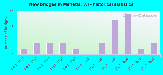
- New bridges - historical statistics
- 11920-1929
- 21930-1939
- 21940-1949
- 21950-1959
- 11960-1969
- 21980-1989
- 61990-1999
- 72000-2009
- 12010-2019
- 22020-2022

- Reconstructed bridges - Historical Statistics
- 11960-1969
- 21970-1979
- 01980-1989
- 11990-1999


- Bridge Condition - Deck
- 4.3%Excellent
- 17.4%Very good
- 47.8%Good
- 21.7%Satisfactory
- 4.3%Fair
- 4.3%Poor

- Bridge Condition - Superstructure
- 4.3%Excellent
- 21.7%Very good
- 43.5%Good
- 13.0%Satisfactory
- 17.4%Fair

- Bridge Condition - Substructure
- 4.3%Excellent
- 8.7%Very good
- 47.8%Good
- 13.0%Satisfactory
- 17.4%Fair
- 8.7%Poor

- Bridge Condition - Channel
- 4.0%Excellent
- 16.0%Very good
- 20.0%Good
- 40.0%Satisfactory
- 20.0%Fair
Find on map >> Show street view
Structure Number: B12001, Location: 2.2M N JCT STH 131 TO S (Lat: 43.418942, Lng: -90.778383), Route carried "on" structure: US 61, Year Built: 1955, Status: Open, Structure Length: 7.37m (24.18ft), Average Daily Traffic: 2,600 (year 2019), Truck Traffic: 10%, Average Future Daily Traffic: 3,600 (year 2040), Design Load: H 20, Features Intersected: KICKAPOO RIVER
Minimum Vertical Clearance: 30+ m (98+ ft), Kilometerpoint: 0.000, Lanes on structure: 2, Base Highway Network: Yes, Owner: State Highway Agency, Approaching Roadway Width: 11.6m (38.1ft), Skew: 4 degrees, Material/Design: Steel continuous, Design/Construction: Stringer/Multi-beam, Number Of Spans In Main Unit: 3, Length of Maximum Span: 27.4m (89.9ft), Curb-To-Curb Width: 8.5m (27.9ft), Out-to-Out Width: 9.4m (30.8ft)
Condition: Deck: Satisfactory, Superstructure: Satisfactory, Substructure: Satisfactory, Channel: Satisfactory, Operating Rating: 44.1 metric tons, Method Used To Determine Operating Rating: Load Factor (LF), Inventory Rating: 25.9 metric tons, Method Used To Determine Inventory Rating: Load Factor (LF), Structural Evaluation: Equal to present minimum criteria, Deck Geometry: Meets minimum limits, Waterway Adequacy: Equal to present desirable criteria, Approach Roadway Alignment: Equal to present desirable criteria, Designated Inspection Frequency: Every 24 months, Underwater Inspection Frequency: Every 60 months, Inspection Date: April 2021, Underwater Inspection Date: October 2018, Deck Structure Type: Concrete Cast-file-Place, Wearing Surface/Protective System: Wearing Surface: Bituminous
Find on map >> Show street view
Structure Number: B120019, Location: 0.3M N JCT STH 60 TO E (Lat: 43.171064, Lng: -90.709111), Route carried "on" structure: US 61, Year Built: 1958, Status: Open, Structure Length: 4.07m (13.35ft), Average Daily Traffic: 2,700 (year 2019), Truck Traffic: 11%, Average Future Daily Traffic: 3,200 (year 2040), Design Load: H 20, Features Intersected: RICHLAND CREEK
Minimum Vertical Clearance: 30+ m (98+ ft), Kilometerpoint: 0.000, Lanes on structure: 2, Base Highway Network: Yes, Owner: State Highway Agency, Approaching Roadway Width: 11.0m (36.1ft), Material/Design: Steel continuous, Design/Construction: Stringer/Multi-beam, Number Of Spans In Main Unit: 3, Length of Maximum Span: 15.2m (49.9ft), Curb-To-Curb Width: 9.1m (29.9ft), Out-to-Out Width: 11.0m (36.1ft)
Condition: Deck: Poor, Superstructure: Good, Substructure: Fair, Channel: Good, Operating Rating: 34.3 metric tons, Method Used To Determine Operating Rating: Load Factor (LF), Inventory Rating: 19.4 metric tons, Method Used To Determine Inventory Rating: Load Factor (LF), Structural Evaluation: Somewhat better than minimum adequacy, Deck Geometry: Meets minimum limits, Waterway Adequacy: Equal to present desirable criteria, Approach Roadway Alignment: Equal to present desirable criteria, Length Of Structure Improvement: 4.51m (14.80ft), Designated Inspection Frequency: Every 24 months, Inspection Date: April 2021, Bridge Improvement Cost: $561,000, Roadway Improvement Cost: $56,000, Total Project Cost: $841,000 ( Estimate for 2021), Deck Structure Type: Concrete Cast-file-Place, Wearing Surface/Protective System: Wearing Surface: Bituminous
Find on map >> Show street view
Structure Number: B120023, Location: 0.3M E JCT USH 61 TO N (Lat: 43.169714, Lng: -90.700208), Route carried "on" structure: State highway 60, Year Built: 1961, Year Reconstructed: 1998, Status: Open, Structure Length: 4.08m (13.39ft), Average Daily Traffic: 1,400 (year 2018), Truck Traffic: 10%, Average Future Daily Traffic: 2,060 (year 2040), Design Load: H 20, Features Intersected: RICHLAND CREEK
Minimum Vertical Clearance: 30+ m (98+ ft), Kilometerpoint: 0.000, Lanes on structure: 2, Owner: State Highway Agency, Approaching Roadway Width: 10.7m (35.1ft), Material/Design: Steel continuous, Design/Construction: Stringer/Multi-beam, Number Of Spans In Main Unit: 3, Length of Maximum Span: 15.2m (49.9ft), Curb-To-Curb Width: 10.4m (34.1ft), Out-to-Out Width: 11.2m (36.7ft)
Condition: Deck: Good, Superstructure: Good, Substructure: Satisfactory, Channel: Very good, Operating Rating: 52.3 metric tons, Method Used To Determine Operating Rating: Load Factor (LF), Inventory Rating: 30.8 metric tons, Method Used To Determine Inventory Rating: Load Factor (LF), Structural Evaluation: Equal to present minimum criteria, Deck Geometry: Equal to present minimum criteria, Waterway Adequacy: Equal to present desirable criteria, Approach Roadway Alignment: Equal to present desirable criteria, Designated Inspection Frequency: Every 24 months, Inspection Date: April 2021, Deck Structure Type: Concrete Cast-file-Place, Wearing Surface/Protective System: Wearing Surface: Monolithic Concrete, Deck Protection: Epoxy Coated Reinforcing
Find on map >> Show street view
Structure Number: B120037, Location: 4.9M E JCT STH 131 (Lat: 43.125217, Lng: -90.770986), Route carried "on" structure: State highway 60, Year Built: 1983, Status: Open, Structure Length: 2.31m (7.58ft), Average Daily Traffic: 2,100 (year 2019), Truck Traffic: 20%, Average Future Daily Traffic: 2,500 (year 2040), Design Load: HS 20, Features Intersected: CLEAR CREEK
Minimum Vertical Clearance: 30+ m (98+ ft), Kilometerpoint: 0.000, Lanes on structure: 2, Owner: State Highway Agency, Approaching Roadway Width: 12.2m (40.0ft), Skew: 2 degrees, Material/Design: Concrete continuous, Design/Construction: Slab, Number Of Spans In Main Unit: 2, Length of Maximum Span: 11.4m (37.4ft), Curb-To-Curb Width: 12.2m (40.0ft), Out-to-Out Width: 13.1m (43.0ft)
Condition: Deck: Good, Superstructure: Good, Substructure: Good, Channel: Good, Operating Rating: 68.6 metric tons, Method Used To Determine Operating Rating: Load Factor (LF), Inventory Rating: 40.5 metric tons, Method Used To Determine Inventory Rating: Load Factor (LF), Structural Evaluation: Better than present minimum criteria, Deck Geometry: Equal to present minimum criteria, Waterway Adequacy: Equal to present desirable criteria, Approach Roadway Alignment: Equal to present desirable criteria, Designated Inspection Frequency: Every 48 months, Inspection Date: April 2021, Deck Structure Type: Concrete Cast-file-Place, Wearing Surface/Protective System: Wearing Surface: Low Slump Concrete, Deck Protection: Epoxy Coated Reinforcing
Find on map >> Show street view
Structure Number: B12004, Location: 0.3M W JCT STH 131 (Lat: 43.241750, Lng: -90.858083), Route carried "on" structure: City street , Year Built: 1983, Status: Open, Structure Length: 3.75m (12.30ft), Average Daily Traffic: 46 (year 2019), Average Future Daily Traffic: 50 (year 2039), Design Load: H 20, Features Intersected: KICKAPOO RIVER, Facility Carried by Structure: LRD HANEY VALLEY R
Minimum Vertical Clearance: 30+ m (98+ ft), Kilometerpoint: 0.000, Lanes on structure: 2, Owner: Town or Township Highway Agency, Approaching Roadway Width: 7.3m (24.0ft), Skew: 1 degrees, Material/Design: Concrete continuous, Design/Construction: Slab, Number Of Spans In Main Unit: 3, Length of Maximum Span: 14.9m (48.9ft), Curb-To-Curb Width: 7.3m (24.0ft), Out-to-Out Width: 7.9m (25.9ft)
Condition: Deck: Satisfactory, Superstructure: Satisfactory, Substructure: Good, Channel: Good, Operating Rating: 52.3 metric tons, Method Used To Determine Operating Rating: Load Factor (LF), Inventory Rating: 30.8 metric tons, Method Used To Determine Inventory Rating: Load Factor (LF), Structural Evaluation: Equal to present minimum criteria, Deck Geometry: Equal to present minimum criteria, Waterway Adequacy: Equal to present desirable criteria, Approach Roadway Alignment: Equal to present desirable criteria, Designated Inspection Frequency: Every 24 months, Inspection Date: April 2020, Deck Structure Type: Concrete Cast-file-Place, Wearing Surface/Protective System: Wearing Surface: Monolithic Concrete
Find on map >> Show street view
Structure Number: B120048, Location: 1.8M N JCT STH 60 (Lat: 43.130889, Lng: -90.804806), Route carried "on" structure: City street , Year Built: 1991, Status: Open, Structure Length: 1.10m (3.61ft), Average Daily Traffic: 45 (year 2019), Truck Traffic: 10%, Average Future Daily Traffic: 49 (year 2039), Design Load: HS 20, Features Intersected: BOYDTOWN CREEK, Facility Carried by Structure: LRD BOYDTOWN HOLLO
Minimum Vertical Clearance: 30+ m (98+ ft), Kilometerpoint: 0.000, Lanes on structure: 2, Owner: Town or Township Highway Agency, Approaching Roadway Width: 7.3m (24.0ft), Skew: 3 degrees, Material/Design: Concrete, Design/Construction: Slab, Number Of Spans In Main Unit: 1, Length of Maximum Span: 10.4m (34.1ft), Curb-To-Curb Width: 7.3m (24.0ft), Out-to-Out Width: 7.9m (25.9ft)
Condition: Deck: Good, Superstructure: Good, Substructure: Good, Channel: Fair, Operating Rating: 62.1 metric tons, Method Used To Determine Operating Rating: Load Factor (LF), Inventory Rating: 35.6 metric tons, Method Used To Determine Inventory Rating: Load Factor (LF), Structural Evaluation: Better than present minimum criteria, Deck Geometry: Equal to present minimum criteria, Waterway Adequacy: Equal to present minimum criteria, Approach Roadway Alignment: Equal to present desirable criteria, Designated Inspection Frequency: Every 24 months, Inspection Date: April 2020, Deck Structure Type: Concrete Cast-file-Place, Wearing Surface/Protective System: Wearing Surface: Monolithic Concrete, Deck Protection: Epoxy Coated Reinforcing
Find on map >> Show street view
Structure Number: B12011, Location: 0.2M W JCT STH 60 (Lat: 43.024639, Lng: -91.032611), Route carried "on" structure: City street , Year Built: 1994, Status: Open, Structure Length: 1.07m (3.51ft), Average Daily Traffic: 44 (year 2019), Average Future Daily Traffic: 48 (year 2039), Design Load: HS 20, Features Intersected: TUCKER HOLLOW CREEK, Facility Carried by Structure: LRD OLD STH 60
Minimum Vertical Clearance: 30+ m (98+ ft), Kilometerpoint: 0.000, Lanes on structure: 2, Owner: Town or Township Highway Agency, Approaching Roadway Width: 7.3m (24.0ft), Skew: 1 degrees, Material/Design: Concrete, Design/Construction: Slab, Number Of Spans In Main Unit: 1, Length of Maximum Span: 10.1m (33.1ft), Curb-To-Curb Width: 7.3m (24.0ft), Out-to-Out Width: 7.9m (25.9ft)
Condition: Deck: Good, Superstructure: Good, Substructure: Good, Channel: Satisfactory, Operating Rating: 65.0 metric tons, Method Used To Determine Operating Rating: Load Factor (LF), Inventory Rating: 38.9 metric tons, Method Used To Determine Inventory Rating: Load Factor (LF), Structural Evaluation: Better than present minimum criteria, Deck Geometry: Equal to present minimum criteria, Waterway Adequacy: Equal to present desirable criteria, Approach Roadway Alignment: Equal to present minimum criteria, Designated Inspection Frequency: Every 24 months, Inspection Date: April 2020, Deck Structure Type: Concrete Cast-file-Place, Wearing Surface/Protective System: Wearing Surface: Monolithic Concrete, Deck Protection: Epoxy Coated Reinforcing
Find on map >> Show street view
Structure Number: B120113, Location: 2.3M W JCT USH 61 (Lat: 43.198306, Lng: -90.766708), Route carried "on" structure: City street , Year Built: 1994, Status: Open, Structure Length: 0.91m (2.99ft), Average Daily Traffic: 20 (year 2019), Truck Traffic: 12%, Average Future Daily Traffic: 21 (year 2039), Design Load: HS 20, Features Intersected: BR RICHLAND CREEK, Facility Carried by Structure: LRD LONELY VALLEY
Minimum Vertical Clearance: 30+ m (98+ ft), Kilometerpoint: 0.000, Lanes on structure: 2, Owner: Town or Township Highway Agency, Approaching Roadway Width: 6.7m (22.0ft), Material/Design: Concrete, Design/Construction: Slab, Number Of Spans In Main Unit: 1, Length of Maximum Span: 8.5m (27.9ft), Curb-To-Curb Width: 7.3m (24.0ft), Out-to-Out Width: 7.9m (25.9ft)
Condition: Deck: Good, Superstructure: Good, Substructure: Satisfactory, Channel: Fair, Operating Rating: 67.0 metric tons, Method Used To Determine Operating Rating: Load Factor (LF), Inventory Rating: 38.9 metric tons, Method Used To Determine Inventory Rating: Load Factor (LF), Structural Evaluation: Equal to present minimum criteria, Deck Geometry: Equal to present minimum criteria, Waterway Adequacy: Equal to present minimum criteria, Approach Roadway Alignment: Equal to present desirable criteria, Designated Inspection Frequency: Every 24 months, Inspection Date: April 2020, Deck Structure Type: Concrete Cast-file-Place, Wearing Surface/Protective System: Wearing Surface: Monolithic Concrete, Deck Protection: Epoxy Coated Reinforcing
Find on map >> Show street view
Structure Number: B120114, Location: 1.3M N JCT STH 60 (Lat: 43.124611, Lng: -90.804778), Route carried "on" structure: City street , Year Built: 1994, Status: Open, Structure Length: 1.28m (4.20ft), Average Daily Traffic: 44 (year 2019), Truck Traffic: 12%, Average Future Daily Traffic: 48 (year 2039), Design Load: HS 20, Features Intersected: BR WISCONSIN RIVER, Facility Carried by Structure: LRD BOYDTOWN HOLLO
Minimum Vertical Clearance: 30+ m (98+ ft), Kilometerpoint: 0.000, Lanes on structure: 2, Owner: Town or Township Highway Agency, Approaching Roadway Width: 6.7m (22.0ft), Skew: 3 degrees, Material/Design: Concrete, Design/Construction: Slab, Number Of Spans In Main Unit: 1, Length of Maximum Span: 12.2m (40.0ft), Curb-To-Curb Width: 7.3m (24.0ft), Out-to-Out Width: 7.9m (25.9ft)
Condition: Deck: Very good, Superstructure: Very good, Substructure: Good, Channel: Satisfactory, Operating Rating: 67.0 metric tons, Method Used To Determine Operating Rating: Load Factor (LF), Inventory Rating: 38.9 metric tons, Method Used To Determine Inventory Rating: Load Factor (LF), Structural Evaluation: Better than present minimum criteria, Deck Geometry: Equal to present minimum criteria, Waterway Adequacy: Equal to present desirable criteria, Approach Roadway Alignment: Equal to present desirable criteria, Designated Inspection Frequency: Every 24 months, Inspection Date: April 2020, Deck Structure Type: Concrete Cast-file-Place, Wearing Surface/Protective System: Wearing Surface: Monolithic Concrete, Deck Protection: Epoxy Coated Reinforcing
Find on map >> Show street view
Structure Number: B120118, Location: 0.7M N JCT STH 133 TO N (Lat: 43.149897, Lng: -90.714456), Route carried "on" structure: US 61, Year Built: 2000, Status: Open, Structure Length: 34.75m (114.01ft), Average Daily Traffic: 5,400 (year 2019), Truck Traffic: 9%, Average Future Daily Traffic: 7,970 (year 2040), Design Load: HS 20, Features Intersected: WISCONSIN RIVER 02
Minimum Vertical Clearance: 30+ m (98+ ft), Kilometerpoint: 0.000, Lanes on structure: 2, Base Highway Network: Yes, Owner: State Highway Agency, Approaching Roadway Width: 13.1m (43.0ft), Material/Design: Prestressed concrete continuous, Design/Construction: Stringer/Multi-beam, Number Of Spans In Main Unit: 8, Length of Maximum Span: 43.4m (142.4ft), Curb-To-Curb Width: 13.2m (43.3ft), Out-to-Out Width: 14.1m (46.3ft)
Condition: Deck: Good, Superstructure: Good, Substructure: Good, Channel: Very good, Operating Rating: 67.0 metric tons, Method Used To Determine Operating Rating: Load Factor (LF), Inventory Rating: 42.1 metric tons, Method Used To Determine Inventory Rating: Load Factor (LF), Structural Evaluation: Better than present minimum criteria, Deck Geometry: Somewhat better than minimum adequacy, Waterway Adequacy: Equal to present desirable criteria, Approach Roadway Alignment: Equal to present desirable criteria, Designated Inspection Frequency: Every 48 months, Underwater Inspection Frequency: Every 60 months, Inspection Date: April 2021, Underwater Inspection Date: September 2020, Deck Structure Type: Concrete Cast-file-Place, Wearing Surface/Protective System: Wearing Surface: Epoxy Overlay, Deck Protection: Epoxy Coated Reinforcing
Find on map >> Show street view
Structure Number: B12012, Location: 1.8M N JCT CTH B (Lat: 43.420444, Lng: -90.860278), Route carried "on" structure: City street , Year Built: 1997, Status: Open, Structure Length: 1.22m (4.00ft), Average Daily Traffic: 27 (year 2019), Average Future Daily Traffic: 29 (year 2039), Design Load: HS 20, Features Intersected: BR JONES VALLEY CREEK, Facility Carried by Structure: LRD NORWEGIAN HOLL
Minimum Vertical Clearance: 30+ m (98+ ft), Kilometerpoint: 0.000, Lanes on structure: 2, Owner: Town or Township Highway Agency, Approaching Roadway Width: 6.7m (22.0ft), Skew: 1 degrees, Material/Design: Concrete, Design/Construction: Slab, Number Of Spans In Main Unit: 1, Length of Maximum Span: 11.6m (38.1ft), Curb-To-Curb Width: 7.3m (24.0ft), Out-to-Out Width: 7.9m (25.9ft)
Condition: Deck: Good, Superstructure: Good, Substructure: Good, Channel: Satisfactory, Operating Rating: 75.1 metric tons, Method Used To Determine Operating Rating: Load Factor (LF), Inventory Rating: 43.7 metric tons, Method Used To Determine Inventory Rating: Load Factor (LF), Structural Evaluation: Better than present minimum criteria, Deck Geometry: Equal to present minimum criteria, Waterway Adequacy: Equal to present minimum criteria, Approach Roadway Alignment: Equal to present desirable criteria, Designated Inspection Frequency: Every 24 months, Inspection Date: April 2020, Deck Structure Type: Concrete Cast-file-Place, Wearing Surface/Protective System: Wearing Surface: Monolithic Concrete, Deck Protection: Epoxy Coated Reinforcing
Find on map >> Show street view
Structure Number: B120127, Location: 6.5M E JCT STH 131 (Lat: 43.136756, Lng: -90.743139), Route carried "on" structure: State highway 60, Year Built: 2001, Status: Open, Structure Length: 0.85m (2.79ft), Average Daily Traffic: 2,700 (year 2019), Average Future Daily Traffic: 2,000 (year 2040), Design Load: HS 20, Features Intersected: DRY RUN
Minimum Vertical Clearance: 30+ m (98+ ft), Kilometerpoint: 0.000, Lanes on structure: 2, Owner: State Highway Agency, Approaching Roadway Width: 10.7m (35.1ft), Skew: 2 degrees, Material/Design: Concrete continuous, Design/Construction: Culvert, Number Of Spans In Main Unit: 2, Length of Maximum Span: 3.7m (12.1ft)
Condition: Channel: Fair, Culverts: Satisfactory, Operating Rating: 53.9 metric tons, Method Used To Determine Operating Rating: Field evaluation and documented engineering judgment, Inventory Rating: 32.4 metric tons, Method Used To Determine Inventory Rating: Field evaluation and documented engineering judgment, Structural Evaluation: Equal to present minimum criteria, Waterway Adequacy: Equal to present desirable criteria, Approach Roadway Alignment: Equal to present desirable criteria, Designated Inspection Frequency: Every 24 months, Inspection Date: April 2021, Deck Structure Type: Concrete Cast-file-Place, Wearing Surface/Protective System: Wearing Surface: Bituminous
Find on map >> Show street view
Structure Number: B120128, Location: 7.4M E JCT STH 131 (Lat: 43.145594, Lng: -90.730814), Route carried "on" structure: State highway 60, Year Built: 2001, Status: Open, Structure Length: 0.59m (1.94ft), Average Daily Traffic: 2,700 (year 2019), Average Future Daily Traffic: 2,100 (year 2040), Design Load: HS 20, Features Intersected: DRY RUN
Minimum Vertical Clearance: 30+ m (98+ ft), Kilometerpoint: 0.000, Lanes on structure: 2, Owner: State Highway Agency, Approaching Roadway Width: 10.7m (35.1ft), Skew: 1 degrees, Material/Design: Concrete continuous, Design/Construction: Culvert, Number Of Spans In Main Unit: 2, Length of Maximum Span: 2.7m (8.9ft)
Condition: Channel: Fair, Culverts: Satisfactory, Operating Rating: 53.9 metric tons, Method Used To Determine Operating Rating: Field evaluation and documented engineering judgment, Inventory Rating: 32.4 metric tons, Method Used To Determine Inventory Rating: Field evaluation and documented engineering judgment, Structural Evaluation: Equal to present minimum criteria, Waterway Adequacy: Equal to present desirable criteria, Approach Roadway Alignment: Equal to present desirable criteria, Designated Inspection Frequency: Every 24 months, Inspection Date: April 2021, Deck Structure Type: Concrete Cast-file-Place, Wearing Surface/Protective System: Wearing Surface: Bituminous
Find on map >> Show street view
Structure Number: B120129, Location: 7.7M E JCT STH 131 TO N (Lat: 43.151056, Lng: -90.720889), Route carried "on" structure: State highway 60, Year Built: 1999, Status: Open, Structure Length: 0.63m (2.07ft), Average Daily Traffic: 2,700 (year 2019), Average Future Daily Traffic: 10 (year 2040), Design Load: HS 20, Features Intersected: DRY RUN
Minimum Vertical Clearance: 30+ m (98+ ft), Kilometerpoint: 0.000, Lanes on structure: 4, Owner: State Highway Agency, Approaching Roadway Width: 10.7m (35.1ft), Material/Design: Concrete continuous, Design/Construction: Culvert, Number Of Spans In Main Unit: 2, Length of Maximum Span: 3.0m (9.8ft)
Condition: Channel: Satisfactory, Culverts: Satisfactory, Operating Rating: 53.9 metric tons, Method Used To Determine Operating Rating: Field evaluation and documented engineering judgment, Inventory Rating: 32.4 metric tons, Method Used To Determine Inventory Rating: Field evaluation and documented engineering judgment, Structural Evaluation: Equal to present minimum criteria, Waterway Adequacy: Equal to present desirable criteria, Approach Roadway Alignment: Equal to present desirable criteria, Designated Inspection Frequency: Every 24 months, Inspection Date: April 2021, Deck Structure Type: Concrete Cast-file-Place, Wearing Surface/Protective System: Wearing Surface: Bituminous
Find on map >> Show street view
Structure Number: B12015, Location: 2.2M E JCT CTH W (Lat: 43.240861, Lng: -90.804528), Route carried "on" structure: City street , Year Built: 2002, Status: Open, Structure Length: 1.37m (4.49ft), Average Daily Traffic: 21 (year 2019), Truck Traffic: 10%, Average Future Daily Traffic: 23 (year 2039), Design Load: HS 20, Features Intersected: SHAW HOLLOW CREEK, Facility Carried by Structure: LRD SHAW HOLLOW RD
Minimum Vertical Clearance: 30+ m (98+ ft), Kilometerpoint: 0.000, Lanes on structure: 2, Owner: Town or Township Highway Agency, Approaching Roadway Width: 7.3m (24.0ft), Skew: 2 degrees, Material/Design: Concrete, Design/Construction: Slab, Number Of Spans In Main Unit: 1, Length of Maximum Span: 12.8m (42.0ft), Curb-To-Curb Width: 7.3m (24.0ft), Out-to-Out Width: 7.9m (25.9ft)
Condition: Deck: Good, Superstructure: Good, Substructure: Good, Channel: Satisfactory, Operating Rating: 67.0 metric tons, Method Used To Determine Operating Rating: Load Factor (LF), Inventory Rating: 38.9 metric tons, Method Used To Determine Inventory Rating: Load Factor (LF), Structural Evaluation: Better than present minimum criteria, Deck Geometry: Equal to present minimum criteria, Waterway Adequacy: Equal to present desirable criteria, Approach Roadway Alignment: Equal to present desirable criteria, Designated Inspection Frequency: Every 24 months, Inspection Date: September 2020, Deck Structure Type: Concrete Cast-file-Place, Wearing Surface/Protective System: Wearing Surface: Monolithic Concrete, Deck Protection: Epoxy Coated Reinforcing
Find on map >> Show street view
Structure Number: B120159, Location: 0.5M S JCT USH 61 (Lat: 43.186500, Lng: -90.739611), Route carried "on" structure: City street , Year Built: 2003, Status: Open, Structure Length: 2.52m (8.27ft), Average Daily Traffic: 185 (year 2019), Truck Traffic: 10%, Average Future Daily Traffic: 203 (year 2039), Design Load: HS 20, Features Intersected: RICHLAND CREEK, Facility Carried by Structure: LRD MARIETTA VALLE
Minimum Vertical Clearance: 30+ m (98+ ft), Kilometerpoint: 0.000, Lanes on structure: 2, Owner: Town or Township Highway Agency, Approaching Roadway Width: 7.9m (25.9ft), Skew: 2 degrees, Material/Design: Concrete continuous, Design/Construction: Slab, Number Of Spans In Main Unit: 2, Length of Maximum Span: 12.2m (40.0ft), Curb-To-Curb Width: 7.3m (24.0ft), Out-to-Out Width: 7.9m (25.9ft)
Condition: Deck: Good, Superstructure: Good, Substructure: Very good, Channel: Satisfactory, Operating Rating: 82.0 metric tons, Method Used To Determine Operating Rating: Load Factor (LF), Inventory Rating: 48.6 metric tons, Method Used To Determine Inventory Rating: Load Factor (LF), Structural Evaluation: Better than present minimum criteria, Deck Geometry: Somewhat better than minimum adequacy, Waterway Adequacy: Equal to present minimum criteria, Approach Roadway Alignment: Equal to present desirable criteria, Designated Inspection Frequency: Every 24 months, Inspection Date: April 2020, Deck Structure Type: Concrete Cast-file-Place, Wearing Surface/Protective System: Wearing Surface: Monolithic Concrete, Deck Protection: Epoxy Coated Reinforcing
Find on map >> Show street view
Structure Number: B120161, Location: 0.4M E JCT CTH K (Lat: 43.076472, Lng: -91.142806), Route carried "on" structure: City street , Year Built: 2003, Status: Open, Structure Length: 6.40m (21.00ft), Average Daily Traffic: 954 (year 2019), Average Future Daily Traffic: 1,049 (year 2039), Design Load: HS 20, Features Intersected: BN-SANTA FE RAILROAD, Facility Carried by Structure: LRD CLIFFWOOD DRIV
Minimum Vertical Clearance: 30+ m (98+ ft), Kilometerpoint: 0.000, Lanes on structure: 2, Owner: City or Municipal Highway Agency, Approaching Roadway Width: 9.1m (29.9ft), Material/Design: Prestressed concrete, Design/Construction: Stringer/Multi-beam, Number Of Spans In Main Unit: 4, Length of Maximum Span: 16.8m (55.1ft), Curb-To-Curb Width: 11.0m (36.1ft), Out-to-Out Width: 11.6m (38.1ft)
Condition: Deck: Good, Superstructure: Very good, Substructure: Good, Operating Rating: 63.7 metric tons, Method Used To Determine Operating Rating: Load Factor (LF), Inventory Rating: 35.6 metric tons, Method Used To Determine Inventory Rating: Load Factor (LF), Structural Evaluation: Better than present minimum criteria, Deck Geometry: Better than present minimum criteria, Underclear: Better than present minimum criteria, Approach Roadway Alignment: Equal to present desirable criteria, Designated Inspection Frequency: Every 48 months, Inspection Date: April 2020, Deck Structure Type: Concrete Cast-file-Place, Wearing Surface/Protective System: Wearing Surface: Epoxy Overlay, Deck Protection: Epoxy Coated Reinforcing
Find on map >> Show street view
Structure Number: B120166, Location: 2.7M W JCT USH 61 (Lat: 43.199444, Lng: -90.773056), Route carried "on" structure: City street , Year Built: 2004, Status: Open, Structure Length: 1.19m (3.90ft), Average Daily Traffic: 106 (year 2019), Truck Traffic: 12%, Average Future Daily Traffic: 116 (year 2039), Design Load: HS 20, Features Intersected: BR RICHLAND CREEK, Facility Carried by Structure: LRD SPRING VALLEY
Minimum Vertical Clearance: 30+ m (98+ ft), Kilometerpoint: 0.000, Lanes on structure: 2, Owner: Town or Township Highway Agency, Approaching Roadway Width: 7.3m (24.0ft), Skew: 3 degrees, Material/Design: Concrete, Design/Construction: Slab, Number Of Spans In Main Unit: 1, Length of Maximum Span: 11.0m (36.1ft), Curb-To-Curb Width: 7.3m (24.0ft), Out-to-Out Width: 8.0m (26.2ft)
Condition: Deck: Very good, Superstructure: Very good, Substructure: Good, Channel: Good, Operating Rating: 78.4 metric tons, Method Used To Determine Operating Rating: Load Factor (LF), Inventory Rating: 47.0 metric tons, Method Used To Determine Inventory Rating: Load Factor (LF), Structural Evaluation: Better than present minimum criteria, Deck Geometry: Somewhat better than minimum adequacy, Waterway Adequacy: Equal to present desirable criteria, Approach Roadway Alignment: Equal to present desirable criteria, Designated Inspection Frequency: Every 48 months, Inspection Date: April 2020, Deck Structure Type: Concrete Cast-file-Place, Wearing Surface/Protective System: Wearing Surface: Monolithic Concrete, Deck Protection: Epoxy Coated Reinforcing
Find on map >> Show street view
Structure Number: B120183, Location: 1.4M N. OF STH 60 (Lat: 43.146222, Lng: -90.778833), Route carried "on" structure: City street , Year Built: 2010, Status: Open, Structure Length: 1.06m (3.48ft), Average Daily Traffic: 102 (year 2019), Truck Traffic: 5%, Average Future Daily Traffic: 112 (year 2039), Design Load: HS 25 or greater, Features Intersected: CLEAR CREEK, Facility Carried by Structure: LRD CLEAR CR ROAD
Minimum Vertical Clearance: 30+ m (98+ ft), Kilometerpoint: 0.000, Lanes on structure: 2, Owner: Town or Township Highway Agency, Approaching Roadway Width: 6.1m (20.0ft), Skew: 3 degrees, Material/Design: Concrete continuous, Design/Construction: Slab, Number Of Spans In Main Unit: 1, Length of Maximum Span: 9.8m (32.2ft), Curb-To-Curb Width: 7.3m (24.0ft), Out-to-Out Width: 7.9m (25.9ft)
Condition: Deck: Very good, Superstructure: Very good, Substructure: Good, Channel: Satisfactory, Operating Rating: 62.1 metric tons, Method Used To Determine Operating Rating: Load Factor (LF), Inventory Rating: 35.6 metric tons, Method Used To Determine Inventory Rating: Load Factor (LF), Structural Evaluation: Better than present minimum criteria, Deck Geometry: Somewhat better than minimum adequacy, Waterway Adequacy: Equal to present minimum criteria, Approach Roadway Alignment: Equal to present desirable criteria, Designated Inspection Frequency: Every 24 months, Inspection Date: April 2020, Deck Structure Type: Concrete Cast-file-Place, Wearing Surface/Protective System: Wearing Surface: Monolithic Concrete, Deck Protection: Epoxy Coated Reinforcing
Find on map >> Show street view
Structure Number: B120248, Location: 0.7M N JCT USH 61 (Lat: 43.232356, Lng: -90.753775), Route carried "on" structure: City street , Year Built: 2021, Status: Open, Structure Length: 1.14m (3.74ft), Average Daily Traffic: 115 (year 2021), Truck Traffic: 5%, Average Future Daily Traffic: 135 (year 2041), Design Load: HL 93, Features Intersected: RICHLAND CREEK, Facility Carried by Structure: LRD BYERS ROAD
Minimum Vertical Clearance: 30+ m (98+ ft), Kilometerpoint: 0.000, Lanes on structure: 2, Owner: Town or Township Highway Agency, Approaching Roadway Width: 7.9m (25.9ft), Material/Design: Concrete, Design/Construction: Slab, Number Of Spans In Main Unit: 1, Length of Maximum Span: 10.7m (35.1ft), Curb-To-Curb Width: 7.3m (24.0ft), Out-to-Out Width: 8.1m (26.6ft)
Condition: Deck: Excellent, Superstructure: Excellent, Substructure: Excellent, Channel: Very good, Operating Rating: 53.5 metric tons, Method Used To Determine Operating Rating: Load and Resistance Factor Rating (LRFR) rating reported by rating factor(RF) method using HL-93 loadings, Inventory Rating: 41.1 metric tons, Method Used To Determine Inventory Rating: Load and Resistance Factor Rating (LRFR) rating reported by rating factor(RF) method using HL-93 loadings, Structural Evaluation: Superior to present desirable criteria, Deck Geometry: Somewhat better than minimum adequacy, Waterway Adequacy: Equal to present minimum criteria, Approach Roadway Alignment: Equal to present desirable criteria, Designated Inspection Frequency: Every 24 months, Inspection Date: June 2021, Deck Structure Type: Concrete Cast-file-Place, Wearing Surface/Protective System: Wearing Surface: Monolithic Concrete, Deck Protection: Epoxy Coated Reinforcing
Find on map >> Show street view
Structure Number: B120249, Location: 0.5M N JCT USH 61 (Lat: 43.172917, Lng: -90.720194), Route carried "on" structure: City street , Year Built: 2021, Status: Open, Structure Length: 1.30m (4.27ft), Average Daily Traffic: 100 (year 2021), Truck Traffic: 4%, Average Future Daily Traffic: 100 (year 2041), Design Load: HL 93, Features Intersected: WOODWARD HOLLOW CREEK, Facility Carried by Structure: LRD MARIETTA VALLE
Minimum Vertical Clearance: 30+ m (98+ ft), Kilometerpoint: 0.000, Lanes on structure: 2, Owner: Town or Township Highway Agency, Approaching Roadway Width: 6.7m (22.0ft), Skew: 2 degrees, Material/Design: Concrete, Design/Construction: Slab, Number Of Spans In Main Unit: 1, Length of Maximum Span: 12.2m (40.0ft), Curb-To-Curb Width: 7.3m (24.0ft), Out-to-Out Width: 8.1m (26.6ft)
Condition: Deck: Very good, Superstructure: Very good, Substructure: Very good, Channel: Excellent, Operating Rating: 49.9 metric tons, Method Used To Determine Operating Rating: Load and Resistance Factor Rating (LRFR) rating reported by rating factor(RF) method using HL-93 loadings, Inventory Rating: 38.6 metric tons, Method Used To Determine Inventory Rating: Load and Resistance Factor Rating (LRFR) rating reported by rating factor(RF) method using HL-93 loadings, Structural Evaluation: Equal to present desirable criteria, Deck Geometry: Equal to present minimum criteria, Waterway Adequacy: Superior to present desirable criteria, Approach Roadway Alignment: Equal to present desirable criteria, Designated Inspection Frequency: Every 24 months, Inspection Date: July 2021, Wearing Surface/Protective System: Wearing Surface: Monolithic Concrete, Deck Protection: Epoxy Coated Reinforcing
Find on map >> Show street view
Structure Number: B120817, Location: 0.2M N JCT CTH E (Lat: 43.187061, Lng: -90.841025), Route carried "on" structure: State highway 131, Year Built: 1941, Year Reconstructed: 1979, Status: Open, Structure Length: 0.88m (2.89ft), Average Daily Traffic: 210 (year 2019), Truck Traffic: 6%, Average Future Daily Traffic: 500 (year 2040), Design Load: H 20, Features Intersected: BR KICKAPOO RIVER
Minimum Vertical Clearance: 30+ m (98+ ft), Kilometerpoint: 0.000, Lanes on structure: 2, Owner: State Highway Agency, Approaching Roadway Width: 7.9m (25.9ft), Material/Design: Steel, Design/Construction: Stringer/Multi-beam, Number Of Spans In Main Unit: 1, Length of Maximum Span: 8.8m (28.9ft), Curb-To-Curb Width: 9.1m (29.9ft), Out-to-Out Width: 9.7m (31.8ft)
Condition: Deck: Good, Superstructure: Fair, Substructure: Poor, Channel: Very good, Operating Rating: 70.2 metric tons, Method Used To Determine Operating Rating: Load Factor (LF), Inventory Rating: 40.5 metric tons, Method Used To Determine Inventory Rating: Load Factor (LF), Structural Evaluation: Meets minimum limits, Deck Geometry: Equal to present minimum criteria, Waterway Adequacy: Equal to present desirable criteria, Approach Roadway Alignment: Equal to present desirable criteria, Length Of Structure Improvement: 1.31m (4.30ft), Designated Inspection Frequency: Every 12 months, Inspection Date: April 2021, Bridge Improvement Cost: $126,000, Roadway Improvement Cost: $12,000, Total Project Cost: $189,000 ( Estimate for 2021), Deck Structure Type: Concrete Cast-file-Place, Wearing Surface/Protective System: Wearing Surface: Monolithic Concrete
Find on map >> Show street view
Structure Number: B120818, Location: 0.8M N JCT CTH E (Lat: 43.194358, Lng: -90.839292), Route carried "on" structure: State highway 131, Year Built: 1941, Year Reconstructed: 1979, Status: Open, Structure Length: 0.73m (2.40ft), Average Daily Traffic: 210 (year 2019), Truck Traffic: 9%, Average Future Daily Traffic: 300 (year 2040), Design Load: H 20, Features Intersected: BR KICKAPOO RIVER
Minimum Vertical Clearance: 30+ m (98+ ft), Kilometerpoint: 0.000, Lanes on structure: 2, Owner: State Highway Agency, Approaching Roadway Width: 7.9m (25.9ft), Material/Design: Steel, Design/Construction: Stringer/Multi-beam, Number Of Spans In Main Unit: 1, Length of Maximum Span: 7.3m (24.0ft), Curb-To-Curb Width: 9.1m (29.9ft), Out-to-Out Width: 9.7m (31.8ft)
Condition: Deck: Satisfactory, Superstructure: Satisfactory, Substructure: Poor, Channel: Good, Operating Rating: 76.7 metric tons, Method Used To Determine Operating Rating: Load Factor (LF), Inventory Rating: 45.4 metric tons, Method Used To Determine Inventory Rating: Load Factor (LF), Structural Evaluation: Meets minimum limits, Deck Geometry: Equal to present minimum criteria, Waterway Adequacy: Equal to present desirable criteria, Approach Roadway Alignment: Equal to present desirable criteria, Length Of Structure Improvement: 1.19m (3.90ft), Designated Inspection Frequency: Every 12 months, Inspection Date: April 2021, Bridge Improvement Cost: $112,000, Roadway Improvement Cost: $11,000, Total Project Cost: $168,000 ( Estimate for 2021), Deck Structure Type: Concrete Cast-file-Place, Wearing Surface/Protective System: Wearing Surface: Monolithic Concrete
Find on map >> Show street view
Structure Number: P120914, Location: 1.0M N JCT STH 60 (Lat: 43.120556, Lng: -90.809500), Route carried "on" structure: City street , Year Built: 1930, Status: Posted for load, Structure Length: 1.25m (4.10ft), Average Daily Traffic: 47 (year 2019), Average Future Daily Traffic: 51 (year 2040), Features Intersected: BR WISCONSIN RIVER, Facility Carried by Structure: LRD HILLDALE RD
Minimum Vertical Clearance: 30+ m (98+ ft), Kilometerpoint: 0.000, Lanes on structure: 2, Owner: Town or Township Highway Agency, Approaching Roadway Width: 5.5m (18.0ft), Material/Design: Steel, Design/Construction: Stringer/Multi-beam, Number Of Spans In Main Unit: 1, Length of Maximum Span: 12.0m (39.4ft), Curb-To-Curb Width: 5.4m (17.7ft), Out-to-Out Width: 5.6m (18.4ft)
Condition: Deck: Fair, Superstructure: Fair, Substructure: Fair, Channel: Satisfactory, Operating Rating: 37.6 metric tons, Method Used To Determine Operating Rating: Load Factor (LF), Inventory Rating: 22.7 metric tons, Method Used To Determine Inventory Rating: Load Factor (LF), Structural Evaluation: Somewhat better than minimum adequacy, Deck Geometry: High priority of corrective action, Waterway Adequacy: Equal to present desirable criteria, Approach Roadway Alignment: Equal to present minimum criteria, Bridge Posting: Required (Relationship of Operating Rating to Maximum Legal Load: 10.0 - 19.9% below), Length Of Structure Improvement: 1.68m (5.51ft), Designated Inspection Frequency: Every 12 months, Inspection Date: April 2021, Bridge Improvement Cost: $130,000, Roadway Improvement Cost: $13,000, Total Project Cost: $196,000 ( Estimate for 2021), Deck Structure Type: Concrete Cast-file-Place, Wearing Surface/Protective System: Wearing Surface: Other
Find on map >> Show street view
Structure Number: P12094, Location: 2.3M N JCT CTH C (Lat: 43.421389, Lng: -90.816028), Route carried "on" structure: City street , Year Built: 1930, Year Reconstructed: 1960, Status: Posted for load, Structure Length: 0.73m (2.40ft), Average Daily Traffic: 205 (year 2019), Average Future Daily Traffic: 225 (year 2040), Features Intersected: BR JOHNSON VALLEY CREEK, Facility Carried by Structure: LRD NORWEGIAN HOLL
Minimum Vertical Clearance: 30+ m (98+ ft), Kilometerpoint: 0.000, Lanes on structure: 2, Owner: Town or Township Highway Agency, Approaching Roadway Width: 5.5m (18.0ft), Skew: 1 degrees, Material/Design: Steel, Design/Construction: Stringer/Multi-beam, Number Of Spans In Main Unit: 1, Length of Maximum Span: 6.9m (22.6ft), Curb-To-Curb Width: 8.5m (27.9ft), Out-to-Out Width: 8.5m (27.9ft)
Condition: Deck: Satisfactory, Superstructure: Fair, Substructure: Fair, Channel: Satisfactory, Operating Rating: 11.4 metric tons, Method Used To Determine Operating Rating: Load Factor (LF), Inventory Rating: 6.5 metric tons, Method Used To Determine Inventory Rating: Load Factor (LF), Structural Evaluation: High priority of replacement, Deck Geometry: Equal to present minimum criteria, Waterway Adequacy: Equal to present desirable criteria, Approach Roadway Alignment: Equal to present minimum criteria, Bridge Posting: Required (Relationship of Operating Rating to Maximum Legal Load: 20.0 - 29.9% below), Length Of Structure Improvement: 1.19m (3.90ft), Designated Inspection Frequency: Every 12 months, Inspection Date: September 2021, Bridge Improvement Cost: $91,000, Roadway Improvement Cost: $9,000, Total Project Cost: $136,000 ( Estimate for 2021), Deck Structure Type: Concrete Cast-file-Place, Wearing Surface/Protective System: Wearing Surface: Bituminous
Find on map >> Show street view
Structure Number: P120941, Location: 0.6M S JCT USH 61 (Lat: 43.183278, Lng: -90.736611), Route carried "on" structure: City street , Year Built: 1927, Status: Open, Structure Length: 0.75m (2.46ft), Average Daily Traffic: 23 (year 2019), Average Future Daily Traffic: 25 (year 2039), Design Load: H 15, Features Intersected: BR RICHLAND CREEK, Facility Carried by Structure: LRD MARIETTA VALLE
Minimum Vertical Clearance: 30+ m (98+ ft), Kilometerpoint: 0.000, Lanes on structure: 2, Owner: Town or Township Highway Agency, Approaching Roadway Width: 7.9m (25.9ft), Skew: 4 degrees, Material/Design: Concrete, Design/Construction: Stringer/Multi-beam, Number Of Spans In Main Unit: 1, Length of Maximum Span: 6.9m (22.6ft), Curb-To-Curb Width: 7.1m (23.3ft), Out-to-Out Width: 8.0m (26.2ft)
Condition: Deck: Satisfactory, Superstructure: Fair, Substructure: Fair, Channel: Fair, Operating Rating: 35.9 metric tons, Method Used To Determine Operating Rating: Load Factor (LF), Inventory Rating: 16.2 metric tons, Method Used To Determine Inventory Rating: Load Factor (LF), Structural Evaluation: Somewhat better than minimum adequacy, Deck Geometry: Somewhat better than minimum adequacy, Waterway Adequacy: Equal to present minimum criteria, Approach Roadway Alignment: Equal to present desirable criteria, Designated Inspection Frequency: Every 24 months, Inspection Date: April 2020, Deck Structure Type: Concrete Cast-file-Place, Wearing Surface/Protective System: Wearing Surface: Bituminous