Bridge Statistics for Marine, Illinois (IL)
Condition, Traffic, Stress, Structural Evaluation, Project Costs
- National Bridge Inventory (NBI) Statistics
- 21Number of bridges
- 217ft / 66.1mTotal length
- $833,000Total costs
- 178,475Total average daily traffic
- 54,867Total average daily truck traffic
- National Bridge Inventory (NBI) Registered Bridges for Marine
- No street view available for this location
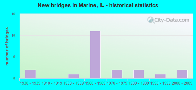
- New bridges - historical statistics
- 21930-1939
- 11950-1959
- 111960-1969
- 21970-1979
- 21980-1989
- 11990-1999
- 22000-2009

- Reconstructed bridges - Historical Statistics
- 11980-1989
- 11990-1999
- 32000-2009


- Bridge Condition - Deck
- 20.0%Very good
- 66.7%Good
- 6.7%Satisfactory
- 6.7%Fair

- Bridge Condition - Superstructure
- 13.3%Very good
- 73.3%Good
- 13.3%Satisfactory

- Bridge Condition - Substructure
- 46.7%Very good
- 46.7%Good
- 6.7%Fair

- Bridge Condition - Channel
- 40.0%Very good
- 20.0%Good
- 33.3%Satisfactory
- 6.7%Fair

- Bridge Condition - Culverts
- 33.3%Good
- 33.3%Fair
- 33.3%Poor
Find on map >> Show street view
Structure Number: 600029, Location: 1.25 M W ILL 4 (Lat: 38.762061, Lng: -89.823792), Route carried "on" structure: Interstate 70, Year Built: 1964, Status: Open, Structure Length: 2.87m (9.42ft), Average Daily Traffic: 16,250 (year 2021), Truck Traffic: 33%, Average Future Daily Traffic: 14,681 (year 2032), Design Load: HS 20+Mod, Features Intersected: BRANCH OF SILVER CRK
Minimum Vertical Clearance: 30+ m (98+ ft), Kilometerpoint: 37.770, Lanes on structure: 2, Base Highway Network: Yes, Owner: State Highway Agency, Approaching Roadway Width: 13.4m (44.0ft), Skew: 1 degrees, Material/Design: Concrete continuous, Design/Construction: Slab, Number Of Spans In Main Unit: 3, Length of Maximum Span: 10.7m (35.1ft), Curb-To-Curb Width: 11.9m (39.0ft), Out-to-Out Width: 13.3m (43.6ft)
Condition: Deck: Very good, Superstructure: Good, Substructure: Very good, Channel: Very good, Operating Rating: 57.0 metric tons, Method Used To Determine Operating Rating: Load Factor (LF) rating reported by rating factor (RF) method using MS18 loading, Inventory Rating: 34.0 metric tons, Method Used To Determine Inventory Rating: Load Factor (LF) rating reported by rating factor (RF) method using MS18 loading, Structural Evaluation: Better than present minimum criteria, Deck Geometry: Equal to present minimum criteria, Waterway Adequacy: Equal to present desirable criteria, Approach Roadway Alignment: Equal to present desirable criteria, Designated Inspection Frequency: Every 24 months, Inspection Date: December 2020, Deck Structure Type: Concrete Cast-file-Place, Wearing Surface/Protective System: Wearing Surface: Low Slump Concrete
Find on map >> Show street view
Structure Number: 60003, Location: 1.25 M W ILL 4 (Lat: 38.762081, Lng: -89.823617), Route carried "on" structure: Interstate 70, Year Built: 1962, Status: Open, Structure Length: 2.87m (9.42ft), Average Daily Traffic: 16,250 (year 2021), Truck Traffic: 33%, Average Future Daily Traffic: 14,681 (year 2032), Design Load: HS 20+Mod, Features Intersected: BRANCH OF SILVER CRK
Minimum Vertical Clearance: 30+ m (98+ ft), Kilometerpoint: 37.786, Lanes on structure: 2, Base Highway Network: Yes, Owner: State Highway Agency, Approaching Roadway Width: 13.4m (44.0ft), Skew: 1 degrees, Material/Design: Concrete continuous, Design/Construction: Slab, Number Of Spans In Main Unit: 3, Length of Maximum Span: 10.7m (35.1ft), Curb-To-Curb Width: 11.9m (39.0ft), Out-to-Out Width: 13.3m (43.6ft)
Condition: Deck: Very good, Superstructure: Good, Substructure: Very good, Channel: Very good, Operating Rating: 44.1 metric tons, Method Used To Determine Operating Rating: Load Factor (LF) rating reported by rating factor (RF) method using MS18 loading, Inventory Rating: 26.6 metric tons, Method Used To Determine Inventory Rating: Load Factor (LF) rating reported by rating factor (RF) method using MS18 loading, Structural Evaluation: Equal to present minimum criteria, Deck Geometry: Equal to present minimum criteria, Waterway Adequacy: Equal to present desirable criteria, Approach Roadway Alignment: Equal to present desirable criteria, Designated Inspection Frequency: Every 24 months, Inspection Date: December 2020, Deck Structure Type: Concrete Cast-file-Place, Wearing Surface/Protective System: Wearing Surface: Low Slump Concrete
Find on map >> Show street view
Structure Number: 600031, Location: 3.5 M E ILL 4 (Lat: 38.767586, Lng: -89.755247), Route carried "on" structure: Interstate 70, Year Built: 1964, Status: Open, Structure Length: 4.40m (14.44ft), Average Daily Traffic: 15,800 (year 2021), Truck Traffic: 33%, Average Future Daily Traffic: 13,144 (year 2032), Design Load: HS 20+Mod, Features Intersected: SUGAR FORK
Minimum Vertical Clearance: 30+ m (98+ ft), Kilometerpoint: 43.821, Lanes on structure: 2, Base Highway Network: Yes, Owner: State Highway Agency, Approaching Roadway Width: 13.4m (44.0ft), Material/Design: Steel continuous, Design/Construction: Stringer/Multi-beam, Number Of Spans In Main Unit: 3, Length of Maximum Span: 16.2m (53.1ft), Curb-To-Curb Width: 12.0m (39.4ft), Out-to-Out Width: 13.4m (44.0ft)
Condition: Deck: Good, Superstructure: Good, Substructure: Good, Channel: Very good, Operating Rating: 66.7 metric tons, Method Used To Determine Operating Rating: Load Factor (LF) rating reported by rating factor (RF) method using MS18 loading, Inventory Rating: 36.0 metric tons, Method Used To Determine Inventory Rating: Load Factor (LF) rating reported by rating factor (RF) method using MS18 loading, Structural Evaluation: Better than present minimum criteria, Deck Geometry: Equal to present minimum criteria, Waterway Adequacy: Equal to present desirable criteria, Approach Roadway Alignment: Equal to present desirable criteria, Designated Inspection Frequency: Every 24 months, Other Special Inspection Frequency: Every 24 months, Inspection Date: December 2020, Other Special Inspection Date: October 2021, Deck Structure Type: Concrete Cast-file-Place, Wearing Surface/Protective System: Wearing Surface: Low Slump Concrete
Find on map >> Show street view
Structure Number: 600032, Location: 3.6 M E ILL 4 (Lat: 38.768622, Lng: -89.752756), Route carried "on" structure: Interstate 70, Year Built: 1964, Status: Open, Structure Length: 4.40m (14.44ft), Average Daily Traffic: 15,800 (year 2021), Truck Traffic: 33%, Average Future Daily Traffic: 13,144 (year 2032), Design Load: HS 20+Mod, Features Intersected: SUGAR FORK
Minimum Vertical Clearance: 30+ m (98+ ft), Kilometerpoint: 44.063, Lanes on structure: 2, Base Highway Network: Yes, Owner: State Highway Agency, Approaching Roadway Width: 13.4m (44.0ft), Material/Design: Steel continuous, Design/Construction: Stringer/Multi-beam, Number Of Spans In Main Unit: 3, Length of Maximum Span: 16.2m (53.1ft), Curb-To-Curb Width: 11.9m (39.0ft), Out-to-Out Width: 13.4m (44.0ft)
Condition: Deck: Fair, Superstructure: Satisfactory, Substructure: Good, Channel: Very good, Operating Rating: 64.8 metric tons, Method Used To Determine Operating Rating: Load Factor (LF) rating reported by rating factor (RF) method using MS18 loading, Inventory Rating: 35.0 metric tons, Method Used To Determine Inventory Rating: Load Factor (LF) rating reported by rating factor (RF) method using MS18 loading, Structural Evaluation: Equal to present minimum criteria, Deck Geometry: Equal to present minimum criteria, Waterway Adequacy: Equal to present minimum criteria, Approach Roadway Alignment: Equal to present desirable criteria, Designated Inspection Frequency: Every 24 months, Inspection Date: December 2020, Deck Structure Type: Concrete Cast-file-Place, Wearing Surface/Protective System: Wearing Surface: Low Slump Concrete
Find on map >> Show street view
Structure Number: 600108, Location: 1.75 M S OF 143 & 4 (Lat: 38.761775, Lng: -89.800675), Route carried "on" structure: State highway 4, Year Built: 1964, Year Reconstructed: 2000, Status: Open, Structure Length: 6.81m (22.34ft), Average Daily Traffic: 7,250 (year 2021), Truck Traffic: 20%, Average Future Daily Traffic: 7,791 (year 2032), Design Load: HS 20, Features Intersected: FAI 70
Minimum Vertical Clearance: 30+ m (98+ ft), Kilometerpoint: 137.466, Lanes on structure: 2, Lanes under structure: 4, Base Highway Network: Yes, Owner: State Highway Agency, Approaching Roadway Width: 13.4m (44.0ft), Material/Design: Steel continuous, Design/Construction: Stringer/Multi-beam, Number Of Spans In Main Unit: 4, Length of Maximum Span: 20.4m (66.9ft), Curb-To-Curb Width: 10.5m (34.4ft), Out-to-Out Width: 11.5m (37.7ft)
Condition: Deck: Good, Superstructure: Very good, Substructure: Good, Operating Rating: 81.0 metric tons, Method Used To Determine Operating Rating: Load Factor (LF) rating reported by rating factor (RF) method using MS18 loading, Inventory Rating: 48.6 metric tons, Method Used To Determine Inventory Rating: Load Factor (LF) rating reported by rating factor (RF) method using MS18 loading, Structural Evaluation: Better than present minimum criteria, Deck Geometry: Meets minimum limits, Underclear: Meets minimum limits, Approach Roadway Alignment: Equal to present desirable criteria, Designated Inspection Frequency: Every 24 months, Inspection Date: October 2021, Deck Structure Type: Concrete Cast-file-Place, Wearing Surface/Protective System: Deck Protection: Epoxy Coated Reinforcing
Find on map >> Show street view
Structure Number: 60015, Location: 1.7 M E MARINE (Lat: 38.778781, Lng: -89.747367), Route carried "on" structure: State highway 143, Year Built: 1939, Year Reconstructed: 2007, Status: Open, Structure Length: 3.84m (12.60ft), Average Daily Traffic: 4,650 (year 2021), Truck Traffic: 7%, Average Future Daily Traffic: 4,028 (year 2032), Design Load: HS 20, Features Intersected: SUGAR FORK CREEK
Minimum Vertical Clearance: 30+ m (98+ ft), Kilometerpoint: 41.118, Lanes on structure: 2, Base Highway Network: Yes, Owner: State Highway Agency, Approaching Roadway Width: 9.1m (29.9ft), Skew: 2 degrees, Material/Design: Prestressed concrete, Design/Construction: Box Beam or Girders - Multiple, Number Of Spans In Main Unit: 3, Length of Maximum Span: 12.2m (40.0ft), Curb-To-Curb Width: 10.1m (33.1ft), Out-to-Out Width: 10.1m (33.1ft)
Condition: Deck: Good, Superstructure: Good, Substructure: Good, Channel: Good, Operating Rating: 71.0 metric tons, Method Used To Determine Operating Rating: Load Factor (LF) rating reported by rating factor (RF) method using MS18 loading, Inventory Rating: 44.1 metric tons, Method Used To Determine Inventory Rating: Load Factor (LF) rating reported by rating factor (RF) method using MS18 loading, Structural Evaluation: Better than present minimum criteria, Deck Geometry: Meets minimum limits, Waterway Adequacy: Superior to present desirable criteria, Approach Roadway Alignment: Equal to present desirable criteria, Length Of Structure Improvement: 3.84m (12.60ft), Designated Inspection Frequency: Every 48 months, Inspection Date: May 2020, Bridge Improvement Cost: $624,000, Roadway Improvement Cost: $29,000, Total Project Cost: $653,000, Deck Structure Type: Concrete Precast Panels, Wearing Surface/Protective System: Wearing Surface: Bituminous, Membrane: Built-up
Find on map >> Show street view
Structure Number: 600151, Location: 1.9 M E MARINE (Lat: 38.776394, Lng: -89.742714), Route carried "on" structure: State highway 143, Year Built: 1964, Year Reconstructed: 2000, Status: Open, Structure Length: 6.92m (22.70ft), Average Daily Traffic: 7,250 (year 2021), Truck Traffic: 6%, Average Future Daily Traffic: 8,109 (year 2032), Design Load: HS 20, Features Intersected: FAI 70
Minimum Vertical Clearance: 30+ m (98+ ft), Kilometerpoint: 41.600, Lanes on structure: 2, Lanes under structure: 4, Base Highway Network: Yes, Owner: State Highway Agency, Approaching Roadway Width: 13.4m (44.0ft), Material/Design: Steel continuous, Design/Construction: Stringer/Multi-beam, Number Of Spans In Main Unit: 4, Length of Maximum Span: 20.7m (67.9ft), Curb-To-Curb Width: 10.5m (34.4ft), Out-to-Out Width: 11.5m (37.7ft)
Condition: Deck: Good, Superstructure: Good, Substructure: Good, Operating Rating: 97.2 metric tons, Method Used To Determine Operating Rating: Load Factor (LF) rating reported by rating factor (RF) method using MS18 loading, Inventory Rating: 62.2 metric tons, Method Used To Determine Inventory Rating: Load Factor (LF) rating reported by rating factor (RF) method using MS18 loading, Structural Evaluation: Better than present minimum criteria, Deck Geometry: Meets minimum limits, Underclear: Meets minimum limits, Approach Roadway Alignment: Equal to present desirable criteria, Designated Inspection Frequency: Every 24 months, Inspection Date: December 2020, Deck Structure Type: Concrete Cast-file-Place, Wearing Surface/Protective System: Deck Protection: Epoxy Coated Reinforcing
Find on map >> Show street view
Structure Number: 600164, Location: 1.25 M E RTE 4 (Lat: 38.764000, Lng: -89.777861), Route carried "on" structure: County highway , Year Built: 1962, Year Reconstructed: 1993, Status: Open, Structure Length: 7.49m (24.57ft), Average Daily Traffic: 775 (year 2021), Truck Traffic: 8%, Average Future Daily Traffic: 742 (year 2032), Design Load: HS 20, Features Intersected: FAI 70, Facility Carried by Structure: FAS 775 (MARINE RD
Minimum Vertical Clearance: 30+ m (98+ ft), Kilometerpoint: 11.619, Lanes on structure: 2, Lanes under structure: 4, Owner: State Highway Agency, Approaching Roadway Width: 9.1m (29.9ft), Skew: 2 degrees, Material/Design: Steel continuous, Design/Construction: Stringer/Multi-beam, Number Of Spans In Main Unit: 4, Length of Maximum Span: 22.7m (74.5ft), Curb-To-Curb Width: 8.5m (27.9ft), Out-to-Out Width: 9.5m (31.2ft)
Condition: Deck: Good, Superstructure: Good, Substructure: Very good, Operating Rating: 71.9 metric tons, Method Used To Determine Operating Rating: Load Factor (LF) rating reported by rating factor (RF) method using MS18 loading, Inventory Rating: 43.1 metric tons, Method Used To Determine Inventory Rating: Load Factor (LF) rating reported by rating factor (RF) method using MS18 loading, Structural Evaluation: Better than present minimum criteria, Deck Geometry: Somewhat better than minimum adequacy, Underclear: Meets minimum limits, Approach Roadway Alignment: Equal to present minimum criteria, Designated Inspection Frequency: Every 24 months, Inspection Date: December 2020, Deck Structure Type: Concrete Cast-file-Place, Wearing Surface/Protective System: Deck Protection: Epoxy Coated Reinforcing
Find on map >> Show street view
Structure Number: 602014, Location: 0.83 MI S OF ILL 143 (Lat: 38.774483, Lng: -89.800908), Route carried "on" structure: State highway 4, Year Built: 1934, Status: Open, Structure Length: 0.68m (2.23ft), Average Daily Traffic: 5,000 (year 2021), Truck Traffic: 17%, Average Future Daily Traffic: 6,095 (year 2032), Features Intersected: TRIB TO SILVER CREEK
Minimum Vertical Clearance: 30+ m (98+ ft), Kilometerpoint: 138.850, Lanes on structure: 2, Base Highway Network: Yes, Owner: State Highway Agency, Approaching Roadway Width: 7.9m (25.9ft), Material/Design: Concrete continuous, Design/Construction: Culvert, Number Of Spans In Main Unit: 2, Length of Maximum Span: 3.0m (9.8ft)
Condition: Channel: Satisfactory, Culverts: Good, Operating Rating: 54.1 metric tons, Method Used To Determine Operating Rating: Field evaluation and documented engineering judgment, Inventory Rating: 32.4 metric tons, Method Used To Determine Inventory Rating: Field evaluation and documented engineering judgment, Structural Evaluation: Better than present minimum criteria, Waterway Adequacy: Equal to present desirable criteria, Approach Roadway Alignment: Equal to present desirable criteria, Designated Inspection Frequency: Every 24 months, Inspection Date: October 2021
Find on map >> Show street view
Structure Number: 603016, Location: 1.4MI E MARINE (Lat: 38.806697, Lng: -89.754728), Route carried "on" structure: County highway , Year Built: 1959, Year Reconstructed: 2003, Status: Open, Structure Length: 3.90m (12.80ft), Average Daily Traffic: 800 (year 2021), Truck Traffic: 10%, Average Future Daily Traffic: 954 (year 2032), Design Load: HS 20, Features Intersected: SUGAR FK CK, Facility Carried by Structure: FAS 775/POCAHONTAS
Minimum Vertical Clearance: 30+ m (98+ ft), Kilometerpoint: 5.874, Lanes on structure: 2, Owner: County Highway Agency, Approaching Roadway Width: 12.2m (40.0ft), Material/Design: Prestressed concrete, Design/Construction: Box Beam or Girders - Multiple, Number Of Spans In Main Unit: 3, Length of Maximum Span: 13.2m (43.3ft), Curb-To-Curb Width: 12.3m (40.4ft), Out-to-Out Width: 12.3m (40.4ft)
Condition: Deck: Good, Superstructure: Good, Substructure: Good, Channel: Satisfactory, Operating Rating: 74.8 metric tons, Method Used To Determine Operating Rating: Load Factor (LF) rating reported by rating factor (RF) method using MS18 loading, Inventory Rating: 36.3 metric tons, Method Used To Determine Inventory Rating: Load Factor (LF) rating reported by rating factor (RF) method using MS18 loading, Structural Evaluation: Better than present minimum criteria, Deck Geometry: Superior to present desirable criteria, Waterway Adequacy: Equal to present desirable criteria, Approach Roadway Alignment: Equal to present desirable criteria, Length Of Structure Improvement: 3.47m (11.38ft), Designated Inspection Frequency: Every 48 months, Inspection Date: April 2020, Bridge Improvement Cost: $164,000, Roadway Improvement Cost: $16,000, Total Project Cost: $180,000, Deck Structure Type: Concrete Precast Panels, Wearing Surface/Protective System: Wearing Surface: Bituminous, Membrane: Built-up
Find on map >> Show street view
Structure Number: 603153, Location: 1 MI SE MARINE (Lat: 38.767272, Lng: -89.753614), Route carried "on" structure: County highway , Year Built: 1963, Status: Open, Structure Length: 1.22m (4.00ft), Average Daily Traffic: 300 (year 2021), Truck Traffic: 7%, Average Future Daily Traffic: 80 (year 2032), Design Load: HS 15, Features Intersected: SUGAR FORK CREEK, Facility Carried by Structure: LOWR MARINE RD/TR2
Minimum Vertical Clearance: 30+ m (98+ ft), Kilometerpoint: 2.237, Lanes on structure: 2, Owner: Town or Township Highway Agency, Approaching Roadway Width: 4.3m (14.1ft), Material/Design: Concrete, Design/Construction: Channel Beam, Number Of Spans In Main Unit: 1, Length of Maximum Span: 12.2m (40.0ft), Curb-To-Curb Width: 6.3m (20.7ft), Out-to-Out Width: 6.9m (22.6ft)
Condition: Deck: Good, Superstructure: Good, Substructure: Fair, Channel: Fair, Operating Rating: 32.4 metric tons, Method Used To Determine Operating Rating: Allowable Stress (AS) rating reported by rating factor (RF) method using MS18 loading, Inventory Rating: 30.8 metric tons, Method Used To Determine Inventory Rating: Allowable Stress (AS) rating reported by rating factor (RF) method using MS18 loading, Structural Evaluation: Somewhat better than minimum adequacy, Deck Geometry: Meets minimum limits, Waterway Adequacy: Better than present minimum criteria, Approach Roadway Alignment: Better than present minimum criteria, Designated Inspection Frequency: Every 24 months, Inspection Date: April 2020, Deck Structure Type: Concrete Precast Panels, Wearing Surface/Protective System: Wearing Surface: Gravel
Find on map >> Show street view
Structure Number: 603222, Location: 2.0 MI SW MARINE (Lat: 38.767750, Lng: -89.810119), Route carried "on" structure: County highway , Year Built: 1977, Status: Open, Structure Length: 1.13m (3.71ft), Average Daily Traffic: 200 (year 2021), Truck Traffic: 16%, Average Future Daily Traffic: 239 (year 2032), Design Load: H 20, Features Intersected: TRIB TO SILVER CK, Facility Carried by Structure: TR 252
Minimum Vertical Clearance: 30+ m (98+ ft), Kilometerpoint: 3.315, Lanes on structure: 2, Owner: Town or Township Highway Agency, Approaching Roadway Width: 4.6m (15.1ft), Material/Design: Steel, Design/Construction: Culvert, Number Of Spans In Main Unit: 2, Length of Maximum Span: 5.2m (17.1ft)
Condition: Channel: Satisfactory, Culverts: Fair, Operating Rating: 43.7 metric tons, Method Used To Determine Operating Rating: Load Factor (LF) rating reported by rating factor (RF) method using MS18 loading, Inventory Rating: 36.9 metric tons, Method Used To Determine Inventory Rating: Load Factor (LF) rating reported by rating factor (RF) method using MS18 loading, Structural Evaluation: Somewhat better than minimum adequacy, Waterway Adequacy: Better than present minimum criteria, Approach Roadway Alignment: Equal to present desirable criteria, Designated Inspection Frequency: Every 24 months, Inspection Date: April 2020
Find on map >> Show street view
Structure Number: 603241, Location: 1.5 MI E MARINE (Lat: 38.789889, Lng: -89.746614), Route carried "on" structure: County highway , Year Built: 1981, Status: Open, Structure Length: 3.69m (12.11ft), Average Daily Traffic: 150 (year 2021), Truck Traffic: 12%, Average Future Daily Traffic: 212 (year 2032), Design Load: HS 20, Features Intersected: SUGAR FORKCREEK, Facility Carried by Structure: MAYER ROAD/ TR 239
Minimum Vertical Clearance: 30+ m (98+ ft), Kilometerpoint: 1.883, Lanes on structure: 2, Owner: Town or Township Highway Agency, Approaching Roadway Width: 6.1m (20.0ft), Material/Design: Prestressed concrete, Design/Construction: Box Beam or Girders - Multiple, Number Of Spans In Main Unit: 3, Length of Maximum Span: 12.2m (40.0ft), Curb-To-Curb Width: 9.1m (29.9ft), Out-to-Out Width: 9.3m (30.5ft)
Condition: Deck: Good, Superstructure: Good, Substructure: Very good, Channel: Satisfactory, Operating Rating: 44.4 metric tons, Method Used To Determine Operating Rating: Assigned rating based on Load Factor Design (LFD) reported by rating factor (RF) using MS18 loading, Inventory Rating: 32.4 metric tons, Method Used To Determine Inventory Rating: Assigned rating based on Load Factor Design (LFD) reported by rating factor (RF) using MS18 loading, Structural Evaluation: Better than present minimum criteria, Deck Geometry: Equal to present minimum criteria, Waterway Adequacy: Equal to present desirable criteria, Approach Roadway Alignment: Equal to present desirable criteria, Designated Inspection Frequency: Every 48 months, Inspection Date: April 2020, Deck Structure Type: Concrete Precast Panels, Wearing Surface/Protective System: Wearing Surface: Gravel
Find on map >> Show street view
Structure Number: 603262, Location: 1.5 MI SE MARINE (Lat: 38.761317, Lng: -89.763350), Route carried "on" structure: County highway , Year Built: 1985, Status: Open, Structure Length: 4.60m (15.09ft), Average Daily Traffic: 100 (year 2021), Truck Traffic: 6%, Average Future Daily Traffic: 80 (year 2032), Design Load: HS 20, Features Intersected: SUGAR FORK CREEK, Facility Carried by Structure: SPRTSMNS LK RD/TR2
Minimum Vertical Clearance: 30+ m (98+ ft), Kilometerpoint: 0.402, Lanes on structure: 2, Owner: Town or Township Highway Agency, Approaching Roadway Width: 5.5m (18.0ft), Material/Design: Prestressed concrete, Design/Construction: Box Beam or Girders - Multiple, Number Of Spans In Main Unit: 3, Length of Maximum Span: 15.2m (49.9ft), Curb-To-Curb Width: 8.6m (28.2ft), Out-to-Out Width: 8.6m (28.2ft)
Condition: Deck: Good, Superstructure: Good, Substructure: Very good, Channel: Good, Operating Rating: 44.4 metric tons, Method Used To Determine Operating Rating: Assigned rating based on Load Factor Design (LFD) reported by rating factor (RF) using MS18 loading, Inventory Rating: 32.4 metric tons, Method Used To Determine Inventory Rating: Assigned rating based on Load Factor Design (LFD) reported by rating factor (RF) using MS18 loading, Structural Evaluation: Better than present minimum criteria, Deck Geometry: Better than present minimum criteria, Waterway Adequacy: Equal to present desirable criteria, Approach Roadway Alignment: Equal to present desirable criteria, Designated Inspection Frequency: Every 48 months, Inspection Date: April 2020, Deck Structure Type: Concrete Precast Panels, Wearing Surface/Protective System: Wearing Surface: Gravel
Find on map >> Show street view
Structure Number: 603294, Location: 3 MI. NE TROY (Lat: 38.755047, Lng: -89.821811), Route carried "on" structure: County highway , Year Built: 1991, Status: Open, Structure Length: 4.32m (14.17ft), Average Daily Traffic: 475 (year 2021), Truck Traffic: 5%, Average Future Daily Traffic: 292 (year 2032), Design Load: HS 20, Features Intersected: SILVER CK., Facility Carried by Structure: LOW. MARINE RD/TR2
Minimum Vertical Clearance: 30+ m (98+ ft), Kilometerpoint: 4.651, Lanes on structure: 2, Owner: Town or Township Highway Agency, Approaching Roadway Width: 6.7m (22.0ft), Skew: 2 degrees, Material/Design: Prestressed concrete, Design/Construction: Box Beam or Girders - Multiple, Number Of Spans In Main Unit: 3, Length of Maximum Span: 18.3m (60.0ft), Curb-To-Curb Width: 8.7m (28.5ft), Out-to-Out Width: 8.7m (28.5ft)
Condition: Deck: Satisfactory, Superstructure: Satisfactory, Substructure: Good, Channel: Good, Operating Rating: 65.1 metric tons, Method Used To Determine Operating Rating: Load Factor (LF) rating reported by rating factor (RF) method using MS18 loading, Inventory Rating: 38.9 metric tons, Method Used To Determine Inventory Rating: Load Factor (LF) rating reported by rating factor (RF) method using MS18 loading, Structural Evaluation: Equal to present minimum criteria, Deck Geometry: Somewhat better than minimum adequacy, Waterway Adequacy: Equal to present minimum criteria, Approach Roadway Alignment: Equal to present minimum criteria, Designated Inspection Frequency: Every 24 months, Inspection Date: August 2020, Deck Structure Type: Concrete Precast Panels, Wearing Surface/Protective System: Wearing Surface: Gravel
Find on map >> Show street view
Structure Number: 603304, Location: 2 MI NW MARINE (Lat: 38.819647, Lng: -89.801925), Route carried "on" structure: County highway , Year Built: 1976, Status: Open, Structure Length: 0.84m (2.76ft), Average Daily Traffic: 50 (year 2021), Truck Traffic: 10%, Average Future Daily Traffic: 53 (year 2032), Design Load: HS 20, Features Intersected: SILVER CR TRIB, Facility Carried by Structure: GOODALL RD/ TR 227
Minimum Vertical Clearance: 30+ m (98+ ft), Kilometerpoint: 1.304, Lanes on structure: 2, Owner: Town or Township Highway Agency, Approaching Roadway Width: 4.9m (16.1ft), Skew: 5 degrees, Material/Design: Steel, Design/Construction: Culvert, Number Of Spans In Main Unit: 1, Length of Maximum Span: 8.1m (26.6ft)
Condition: Channel: Satisfactory, Culverts: Poor, Operating Rating: 40.5 metric tons, Method Used To Determine Operating Rating: Field evaluation and documented engineering judgment, Inventory Rating: 24.3 metric tons, Method Used To Determine Inventory Rating: Field evaluation and documented engineering judgment, Structural Evaluation: Meets minimum limits, Waterway Adequacy: Better than present minimum criteria, Approach Roadway Alignment: Equal to present desirable criteria, Designated Inspection Frequency: Every 24 months, Inspection Date: April 2020
Find on map >> Show street view
Structure Number: 603337, Location: 2.5 MI E MARINE (Lat: 38.808469, Lng: -89.740589), Route carried "on" structure: County highway , Year Built: 2006, Status: Open, Structure Length: 3.29m (10.79ft), Average Daily Traffic: 100 (year 2021), Truck Traffic: 12%, Average Future Daily Traffic: 186 (year 2032), Design Load: HS 20, Features Intersected: SAND CREEK, Facility Carried by Structure: YANN RD/TR 298
Minimum Vertical Clearance: 30+ m (98+ ft), Kilometerpoint: 0.531, Lanes on structure: 2, Owner: Town or Township Highway Agency, Approaching Roadway Width: 7.3m (24.0ft), Material/Design: Prestressed concrete, Design/Construction: Box Beam or Girders - Multiple, Number Of Spans In Main Unit: 3, Length of Maximum Span: 12.2m (40.0ft), Curb-To-Curb Width: 9.2m (30.2ft), Out-to-Out Width: 9.2m (30.2ft)
Condition: Deck: Very good, Superstructure: Very good, Substructure: Very good, Channel: Very good, Operating Rating: 44.1 metric tons, Method Used To Determine Operating Rating: Assigned rating based on Load Factor Design (LFD) reported by rating factor (RF) using MS18 loading, Inventory Rating: 32.4 metric tons, Method Used To Determine Inventory Rating: Assigned rating based on Load Factor Design (LFD) reported by rating factor (RF) using MS18 loading, Structural Evaluation: Equal to present desirable criteria, Deck Geometry: Better than present minimum criteria, Waterway Adequacy: Equal to present desirable criteria, Approach Roadway Alignment: Equal to present desirable criteria, Designated Inspection Frequency: Every 48 months, Inspection Date: April 2020, Deck Structure Type: Concrete Precast Panels, Wearing Surface/Protective System: Wearing Surface: Bituminous, Membrane: Built-up
Find on map >> Show street view
Structure Number: 603343, Location: 4.7 W GRANTFORK (Lat: 38.829864, Lng: -89.756411), Route carried "on" structure: County highway , Year Built: 2007, Status: Open, Structure Length: 2.79m (9.15ft), Average Daily Traffic: 375 (year 2021), Truck Traffic: 16%, Average Future Daily Traffic: 424 (year 2032), Design Load: HS 20, Features Intersected: SUGAR FORK, Facility Carried by Structure: FAS 766/FRUIT RD
Minimum Vertical Clearance: 30+ m (98+ ft), Kilometerpoint: 13.550, Lanes on structure: 2, Owner: County Highway Agency, Approaching Roadway Width: 7.3m (24.0ft), Material/Design: Prestressed concrete, Design/Construction: Box Beam or Girders - Multiple, Number Of Spans In Main Unit: 3, Length of Maximum Span: 12.2m (40.0ft), Curb-To-Curb Width: 10.1m (33.1ft), Out-to-Out Width: 10.1m (33.1ft)
Condition: Deck: Good, Superstructure: Good, Substructure: Very good, Channel: Very good, Operating Rating: 44.1 metric tons, Method Used To Determine Operating Rating: Assigned rating based on Load Factor Design (LFD) reported by rating factor (RF) using MS18 loading, Inventory Rating: 32.4 metric tons, Method Used To Determine Inventory Rating: Assigned rating based on Load Factor Design (LFD) reported by rating factor (RF) using MS18 loading, Structural Evaluation: Better than present minimum criteria, Deck Geometry: Better than present minimum criteria, Waterway Adequacy: Superior to present desirable criteria, Approach Roadway Alignment: Equal to present desirable criteria, Designated Inspection Frequency: Every 48 months, Inspection Date: April 2020, Deck Structure Type: Concrete Precast Panels, Wearing Surface/Protective System: Wearing Surface: Bituminous, Membrane: Built-up
Find on map >> Show street view
Structure Number: 600108, Location: 1.75 M S OF 143 & 4 (Lat: 38.761775, Lng: -89.800675), Route carried "under" structure: Interstate 70, Year Built: 1964, Structure Length: 0. m, Average Daily Traffic: 31,600 (year 2021), Truck Traffic: 33%, Features Intersected: FAI 70, Facility Carried by Structure: ILL 4
Minimum Vertical Clearance: 4.95m (16.24ft), Kilometerpoint: 39.830, Lanes on structure: 2, Lanes under structure: 4, Material/Design: Steel continuous, Design/Construction: Stringer/Multi-beam, Length of Maximum Span: 20.4m (66.9ft)
Find on map >> Show street view
Structure Number: 600151, Location: 1.9 M E MARINE (Lat: 38.776394, Lng: -89.742714), Route carried "under" structure: Interstate 70, Year Built: 1964, Structure Length: 0. m, Average Daily Traffic: 23,700 (year 2021), Truck Traffic: 40%, Features Intersected: FAI 70, Facility Carried by Structure: ILL 143
Minimum Vertical Clearance: 5.26m (17.26ft), Kilometerpoint: 45.318, Lanes on structure: 2, Lanes under structure: 4, Material/Design: Steel continuous, Design/Construction: Stringer/Multi-beam, Length of Maximum Span: 20.7m (67.9ft)
Find on map >> Show street view
Structure Number: 600164, Location: 1.25 M E RTE 4 (Lat: 38.764000, Lng: -89.777861), Route carried "under" structure: Interstate 70, Year Built: 1962, Structure Length: 0. m, Average Daily Traffic: 31,600 (year 2021), Truck Traffic: 33%, Features Intersected: FAI 70, Facility Carried by Structure: FAS 775 (MARINE RD
Minimum Vertical Clearance: 4.95m (16.24ft), Kilometerpoint: 41.842, Lanes on structure: 2, Lanes under structure: 4, Material/Design: Steel continuous, Design/Construction: Stringer/Multi-beam, Length of Maximum Span: 22.7m (74.5ft)