Bridge Statistics for Marion, Michigan (MI)
Condition, Traffic, Stress, Structural Evaluation, Project Costs
- National Bridge Inventory (NBI) Statistics
- 16Number of bridges
- 82ft / 25.3mTotal length
- $850,701,000Total costs
- 21,581Total average daily traffic
- 1,735Total average daily truck traffic
- 32,154Total future (year 2018) average daily traffic
- National Bridge Inventory (NBI) Registered Bridges for Marion
- No street view available for this location
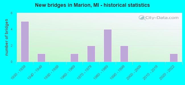
- New bridges - historical statistics
- 51930-1939
- 11940-1949
- 11960-1969
- 21970-1979
- 41980-1989
- 21990-1999
- 12020-2022


- Bridge Condition - Deck
- 10.0%Excellent
- 20.0%Very good
- 40.0%Good
- 20.0%Satisfactory
- 10.0%Fair

- Bridge Condition - Superstructure
- 8.3%Excellent
- 8.3%Very good
- 50.0%Good
- 25.0%Satisfactory
- 8.3%Poor

- Bridge Condition - Substructure
- 8.3%Excellent
- 25.0%Very good
- 33.3%Good
- 8.3%Satisfactory
- 8.3%Fair
- 16.7%Poor

- Bridge Condition - Channel
- 25.0%Very good
- 31.3%Good
- 31.3%Satisfactory
- 12.5%Fair

- Bridge Condition - Culverts
- 50.0%Good
- 25.0%Fair
- 25.0%Poor
Find on map >> Show street view
Structure Number: 1765, Location: REDDING TWP SEC 6 (Lat: 44.062922, Lng: -85.078264), Route carried "on" structure: ServiceCounty highway , Year Built: 1988, Status: Open, Structure Length: 0.73m (2.40ft), Average Daily Traffic: 160 (year 2006), Average Future Daily Traffic: 300 (year 2024), Design Load: HS 20+Mod, Features Intersected: GISS-I-WAS CREEK, Facility Carried by Structure: KIRBY AVENUE
Minimum Vertical Clearance: 30.48m (100.00ft), Kilometerpoint: 2.189, Lanes on structure: 2, Owner: County Highway Agency, Approaching Roadway Width: 9.1m (29.9ft), Material/Design: Concrete, Design/Construction: Arch - Deck, Number Of Spans In Main Unit: 1, Length of Maximum Span: 6.7m (22.0ft), Curb-To-Curb Width: 9.1m (29.9ft), Out-to-Out Width: 9.7m (31.8ft)
Condition: Superstructure: Good, Substructure: Good, Channel: Very good, Operating Rating: 53.2 metric tons, Method Used To Determine Operating Rating: Field evaluation and documented engineering judgment, Inventory Rating: 32.0 metric tons, Method Used To Determine Inventory Rating: Field evaluation and documented engineering judgment, Structural Evaluation: Better than present minimum criteria, Deck Geometry: Equal to present minimum criteria, Waterway Adequacy: Superior to present desirable criteria, Approach Roadway Alignment: Superior to present desirable criteria, Designated Inspection Frequency: Every 24 months, Inspection Date: June 2020, Deck Structure Type: Concrete Cast-file-Place, Wearing Surface/Protective System: Wearing Surface: Bituminous, Membrane: Preformed Fabric, Deck Protection: Epoxy Coated Reinforcing
Find on map >> Show street view
Structure Number: 8592, Location: 0.1 MI N OF M-115 (Lat: 44.033236, Lng: -85.147783), Route carried "on" structure: State highway 66, Year Built: 1940, Year Reconstructed: 2015, Status: Open, Structure Length: 0.71m (2.33ft), Average Daily Traffic: 1,864 (year 2014), Truck Traffic: 13%, Average Future Daily Traffic: 2,144 (year 2034), Design Load: Greater than HL93, Features Intersected: WEST BRANCH R (COYLE CR)
Minimum Vertical Clearance: 30.48m (100.00ft), Kilometerpoint: 24.400, Lanes on structure: 2, Base Highway Network: Yes (Inventory Route: 128, Subroute: 10), Owner: State Highway Agency, Approaching Roadway Width: 12.3m (40.4ft), Material/Design: Prestressed concrete, Design/Construction: Box Beam or Girders - Single/Spread, Number Of Spans In Main Unit: 1, Length of Maximum Span: 6.4m (21.0ft), Curb-To-Curb Width: 12.2m (40.0ft), Out-to-Out Width: 13.2m (43.3ft)
Condition: Deck: Very good, Superstructure: Very good, Substructure: Good, Channel: Good, Operating Rating: 79.4 metric tons, Method Used To Determine Operating Rating: Load and Resistance Factor Rating (LRFR) rating reported by rating factor(RF) method using HL-93 loadings, Inventory Rating: 61.2 metric tons, Method Used To Determine Inventory Rating: Load and Resistance Factor Rating (LRFR) rating reported by rating factor(RF) method using HL-93 loadings, Structural Evaluation: Better than present minimum criteria, Deck Geometry: Better than present minimum criteria, Waterway Adequacy: Equal to present desirable criteria, Approach Roadway Alignment: Better than present minimum criteria, Designated Inspection Frequency: Every 24 months, Inspection Date: August 2020, Deck Structure Type: Concrete Cast-file-Place, Wearing Surface/Protective System: Wearing Surface: Monolithic Concrete, Deck Protection: Epoxy Coated Reinforcing
Find on map >> Show street view
Structure Number: 8593, Location: 2.2 MI N OF M-61 (Lat: 44.076928, Lng: -85.147344), Route carried "on" structure: State highway 66, Year Built: 1995, Status: Open, Structure Length: 2.43m (7.97ft), Average Daily Traffic: 1,685 (year 2007), Truck Traffic: 9%, Average Future Daily Traffic: 2,626 (year 2018), Design Load: HS 25 or greater, Features Intersected: MIDDLE BRANCH RIVER
Minimum Vertical Clearance: 30.48m (100.00ft), Kilometerpoint: 29.252, Lanes on structure: 2, Base Highway Network: Yes (Inventory Route: 128, Subroute: 10), Owner: State Highway Agency, Approaching Roadway Width: 10.4m (34.1ft), Skew: 3 degrees, Material/Design: Prestressed concrete, Design/Construction: Box Beam or Girders - Multiple, Number Of Spans In Main Unit: 1, Length of Maximum Span: 23.1m (75.8ft), Curb-To-Curb Width: 13.4m (44.0ft), Out-to-Out Width: 14.4m (47.2ft)
Condition: Deck: Good, Superstructure: Good, Substructure: Very good, Channel: Good, Operating Rating: 80.4 metric tons, Method Used To Determine Operating Rating: Load Factor (LF) rating reported by rating factor (RF) method using MS18 loading, Inventory Rating: 40.5 metric tons, Method Used To Determine Inventory Rating: Load Factor (LF) rating reported by rating factor (RF) method using MS18 loading, Structural Evaluation: Better than present minimum criteria, Deck Geometry: Equal to present desirable criteria, Waterway Adequacy: Equal to present minimum criteria, Approach Roadway Alignment: Somewhat better than minimum adequacy, Designated Inspection Frequency: Every 24 months, Inspection Date: September 2020, Deck Structure Type: Concrete Cast-file-Place, Wearing Surface/Protective System: Wearing Surface: Monolithic Concrete, Deck Protection: Epoxy Coated Reinforcing
Find on map >> Show street view
Structure Number: 8594, Location: 3.8 MI N OF M-61 (Lat: 44.101583, Lng: -85.147458), Route carried "on" structure: State highway 66, Year Built: 1939, Status: Open, Structure Length: 1.37m (4.49ft), Average Daily Traffic: 3,158 (year 2007), Truck Traffic: 7%, Average Future Daily Traffic: 3,298 (year 2018), Design Load: H 20, Features Intersected: MIDDLE BRANCH RIVER
Minimum Vertical Clearance: 30.48m (100.00ft), Kilometerpoint: 31.993, Lanes on structure: 2, Base Highway Network: Yes (Inventory Route: 128, Subroute: 10), Owner: State Highway Agency, Approaching Roadway Width: 12.2m (40.0ft), Skew: 2 degrees, Material/Design: Steel, Design/Construction: Stringer/Multi-beam, Number Of Spans In Main Unit: 1, Length of Maximum Span: 13.7m (44.9ft), Curb or Sidewalk Widths: Left: 1.2m (3.9ft), Right: 1.2m (3.9ft), Curb-To-Curb Width: 12.2m (40.0ft), Out-to-Out Width: 15.3m (50.2ft)
Condition: Deck: Fair, Superstructure: Satisfactory, Substructure: Satisfactory, Channel: Satisfactory, Operating Rating: 52.2 metric tons, Method Used To Determine Operating Rating: Load Factor (LF) rating reported by rating factor (RF) method using MS18 loading, Inventory Rating: 31.1 metric tons, Method Used To Determine Inventory Rating: Load Factor (LF) rating reported by rating factor (RF) method using MS18 loading, Structural Evaluation: Equal to present minimum criteria, Deck Geometry: Equal to present minimum criteria, Waterway Adequacy: Equal to present desirable criteria, Approach Roadway Alignment: Equal to present desirable criteria, Length Of Structure Improvement: 1.37m (4.49ft), Designated Inspection Frequency: Every 24 months, Inspection Date: September 2020, Bridge Improvement Cost: $23,000, Roadway Improvement Cost: $2,000, Total Project Cost: $26,000, Deck Structure Type: Concrete Cast-file-Place, Wearing Surface/Protective System: Wearing Surface: Bituminous
Find on map >> Show street view
Structure Number: 8595, Location: 4.5 MI N OF M-61 (Lat: 44.111064, Lng: -85.147517), Route carried "on" structure: State highway 66, Year Built: 1939, Status: Open, Structure Length: 1.37m (4.49ft), Average Daily Traffic: 1,485 (year 2007), Truck Traffic: 8%, Average Future Daily Traffic: 3,410 (year 2018), Design Load: H 20, Features Intersected: MIDDLE BRANCH RIVER
Minimum Vertical Clearance: 30.48m (100.00ft), Kilometerpoint: 33.044, Lanes on structure: 2, Base Highway Network: Yes (Inventory Route: 128, Subroute: 10), Owner: State Highway Agency, Approaching Roadway Width: 12.2m (40.0ft), Material/Design: Steel, Design/Construction: Stringer/Multi-beam, Number Of Spans In Main Unit: 1, Length of Maximum Span: 13.7m (44.9ft), Curb or Sidewalk Widths: Left: 1.2m (3.9ft), Right: 1.2m (3.9ft), Curb-To-Curb Width: 12.2m (40.0ft), Out-to-Out Width: 15.3m (50.2ft)
Condition: Deck: Very good, Superstructure: Good, Substructure: Fair, Channel: Fair, Operating Rating: 51.5 metric tons, Method Used To Determine Operating Rating: Load Factor (LF) rating reported by rating factor (RF) method using MS18 loading, Inventory Rating: 30.8 metric tons, Method Used To Determine Inventory Rating: Load Factor (LF) rating reported by rating factor (RF) method using MS18 loading, Structural Evaluation: Somewhat better than minimum adequacy, Deck Geometry: Better than present minimum criteria, Waterway Adequacy: Equal to present desirable criteria, Approach Roadway Alignment: Equal to present desirable criteria, Length Of Structure Improvement: 1.37m (4.49ft), Designated Inspection Frequency: Every 24 months, Inspection Date: September 2020, Bridge Improvement Cost: $51,000, Roadway Improvement Cost: $2,000, Total Project Cost: $26,000, Deck Structure Type: Concrete Cast-file-Place, Wearing Surface/Protective System: Wearing Surface: Bituminous
Find on map >> Show street view
Structure Number: 8599, Location: 0.3 M NW OF M-66 (Lat: 44.035050, Lng: -85.153453), Route carried "on" structure: State highway 115, Year Built: 1937, Status: Open, Structure Length: 0.84m (2.76ft), Average Daily Traffic: 4,184 (year 2007), Truck Traffic: 14%, Average Future Daily Traffic: 5,004 (year 2018), Design Load: H 15, Features Intersected: WEST BRANCH RIVER
Minimum Vertical Clearance: 30.48m (100.00ft), Kilometerpoint: 21.568, Lanes on structure: 2, Base Highway Network: Yes (Inventory Route: 129, Subroute: 9), Owner: State Highway Agency, Approaching Roadway Width: 11.9m (39.0ft), Skew: 3 degrees, Material/Design: Concrete, Design/Construction: Tee Beam, Number Of Spans In Main Unit: 1, Length of Maximum Span: 8.4m (27.6ft), Curb-To-Curb Width: 13.4m (44.0ft), Out-to-Out Width: 14.3m (46.9ft)
Condition: Deck: Satisfactory, Superstructure: Satisfactory, Substructure: Poor, Channel: Good, Operating Rating: 78.7 metric tons, Method Used To Determine Operating Rating: Load Factor (LF) rating reported by rating factor (RF) method using MS18 loading, Inventory Rating: 47.3 metric tons, Method Used To Determine Inventory Rating: Load Factor (LF) rating reported by rating factor (RF) method using MS18 loading, Structural Evaluation: Meets minimum limits, Deck Geometry: Better than present minimum criteria, Waterway Adequacy: Equal to present minimum criteria, Approach Roadway Alignment: Somewhat better than minimum adequacy, Designated Inspection Frequency: Every 12 months, Inspection Date: June 2021, Deck Structure Type: Concrete Cast-file-Place, Wearing Surface/Protective System: Wearing Surface: Epoxy Overlay
Find on map >> Show street view
Structure Number: 8602, Location: 1.5 MI E OF M-115 (Lat: 44.102328, Lng: -85.216200), Route carried "on" structure: Alternate County highway 61, Year Built: 1938, Status: Open, Structure Length: 1.22m (4.00ft), Average Daily Traffic: 1,850 (year 2017), Truck Traffic: 3%, Average Future Daily Traffic: 3,600 (year 2037), Design Load: H 15, Features Intersected: MIDDLE BRANCH RIVER, Facility Carried by Structure: 20 MILE RD
Minimum Vertical Clearance: 30+ m (98+ ft), Kilometerpoint: 27.873, Lanes on structure: 2, Base Highway Network: Yes (Inventory Route: 128, Subroute: 10), Owner: County Highway Agency, Approaching Roadway Width: 11.0m (36.1ft), Material/Design: Concrete, Design/Construction: Culvert, Number Of Spans In Main Unit: 2, Length of Maximum Span: 6.1m (20.0ft), Curb-To-Curb Width: 13.7m (44.9ft), Out-to-Out Width: 18.6m (61.0ft)
Condition: Channel: Satisfactory, Culverts: Good, Operating Rating: 54.5 metric tons, Method Used To Determine Operating Rating: Field evaluation and documented engineering judgment, Inventory Rating: 32.7 metric tons, Method Used To Determine Inventory Rating: Field evaluation and documented engineering judgment, Structural Evaluation: Better than present minimum criteria, Deck Geometry: Superior to present desirable criteria, Waterway Adequacy: Equal to present minimum criteria, Approach Roadway Alignment: Equal to present desirable criteria, Length Of Structure Improvement: 1.22m (4.00ft), Designated Inspection Frequency: Every 24 months, Inspection Date: January 2022, Bridge Improvement Cost: $10,000, Roadway Improvement Cost: $2,000, Total Project Cost: $12,000, Wearing Surface/Protective System: Wearing Surface: Bituminous
Find on map >> Show street view
Structure Number: 8603, Location: 0.1 MI E OF M-66 (Lat: 44.102475, Lng: -85.146356), Route carried "on" structure: City street 61, Year Built: 1939, Status: Posted for load, Structure Length: 0.82m (2.69ft), Average Daily Traffic: 3,600 (year 2008), Truck Traffic: 5%, Average Future Daily Traffic: 6,000 (year 2028), Design Load: H 15, Features Intersected: MIDDLE BRANCH RIVER
Minimum Vertical Clearance: 30.48m (100.00ft), Kilometerpoint: 33.464, Lanes on structure: 4, Base Highway Network: Yes (Inventory Route: 128, Subroute: 10), Owner: City or Municipal Highway Agency, Approaching Roadway Width: 26.5m (86.9ft), Skew: 3 degrees, Material/Design: Concrete, Design/Construction: Arch - Deck, Number Of Spans In Main Unit: 1, Length of Maximum Span: 7.6m (24.9ft), Curb or Sidewalk Widths: Left: 4.6m (15.1ft), Right: 4.6m (15.1ft), Curb-To-Curb Width: 26.5m (86.9ft), Out-to-Out Width: 35.7m (117.1ft)
Condition: Superstructure: Poor, Substructure: Poor, Channel: Satisfactory, Operating Rating: 16.7 metric tons, Method Used To Determine Operating Rating: Field evaluation and documented engineering judgment, Inventory Rating: 9.8 metric tons, Method Used To Determine Inventory Rating: Field evaluation and documented engineering judgment, Structural Evaluation: High priority of replacement, Deck Geometry: Superior to present desirable criteria, Waterway Adequacy: Superior to present desirable criteria, Approach Roadway Alignment: Better than present minimum criteria, Bridge Posting: Required (Relationship of Operating Rating to Maximum Legal Load: > 39.9% below), Length Of Structure Improvement: 0.91m (2.99ft), Designated Inspection Frequency: Every 12 months, Inspection Date: July 2021, Bridge Improvement Cost: $750,000,000, Roadway Improvement Cost: $100,000,000, Total Project Cost: $850,000,000, Deck Structure Type: Concrete Cast-file-Place, Wearing Surface/Protective System: Wearing Surface: Bituminous
Find on map >> Show street view
Structure Number: 8605, Location: 5 MI SE OF MARION (Lat: 44.044747, Lng: -85.124528), Route carried "on" structure: State highway 61, Year Built: 1973, Status: Open, Structure Length: 5.64m (18.50ft), Average Daily Traffic: 1,493 (year 2007), Truck Traffic: 10%, Average Future Daily Traffic: 1,926 (year 2018), Design Load: HS 20, Features Intersected: MIDDLE BR MUSKEGON RIVER
Minimum Vertical Clearance: 30.48m (100.00ft), Kilometerpoint: 3.327, Lanes on structure: 2, Base Highway Network: Yes (Inventory Route: 128, Subroute: 10), Owner: State Highway Agency, Approaching Roadway Width: 14.3m (46.9ft), Skew: 4 degrees, Material/Design: Steel, Design/Construction: Stringer/Multi-beam, Number Of Spans In Main Unit: 3, Length of Maximum Span: 21.0m (68.9ft), Curb-To-Curb Width: 14.6m (47.9ft), Out-to-Out Width: 15.1m (49.5ft)
Condition: Deck: Good, Superstructure: Satisfactory, Substructure: Good, Channel: Satisfactory, Operating Rating: 80.4 metric tons, Method Used To Determine Operating Rating: Load Factor (LF) rating reported by rating factor (RF) method using MS18 loading, Inventory Rating: 48.0 metric tons, Method Used To Determine Inventory Rating: Load Factor (LF) rating reported by rating factor (RF) method using MS18 loading, Structural Evaluation: Equal to present minimum criteria, Deck Geometry: Superior to present desirable criteria, Waterway Adequacy: Better than present minimum criteria, Approach Roadway Alignment: Equal to present minimum criteria, Length Of Structure Improvement: 5.64m (18.50ft), Designated Inspection Frequency: Every 24 months, Inspection Date: June 2021, Bridge Improvement Cost: $88,000, Roadway Improvement Cost: $5,000, Total Project Cost: $57,000, Deck Structure Type: Concrete Cast-file-Place, Wearing Surface/Protective System: Wearing Surface: Epoxy Overlay
Find on map >> Show street view
Structure Number: 8617, Location: SECTION 12 T20N R7W (Lat: 44.141747, Lng: -85.097442), Route carried "on" structure: County highway , Year Built: 2021, Status: Open, Structure Length: 1.40m (4.59ft), Average Daily Traffic: 477 (year 2020), Truck Traffic: 1%, Average Future Daily Traffic: 859 (year 2040), Design Load: Greater than HL93, Features Intersected: W BR CLAM RIVER, Facility Carried by Structure: 5TH AVE
Minimum Vertical Clearance: 30.48m (100.00ft), Kilometerpoint: 9.172, Lanes on structure: 2, Owner: County Highway Agency, Approaching Roadway Width: 10.4m (34.1ft), Material/Design: Prestressed concrete, Design/Construction: Box Beam or Girders - Multiple, Number Of Spans In Main Unit: 1, Length of Maximum Span: 13.8m (45.3ft), Curb-To-Curb Width: 10.4m (34.1ft), Out-to-Out Width: 11.2m (36.7ft)
Condition: Deck: Excellent, Superstructure: Excellent, Substructure: Excellent, Channel: Very good, Operating Rating: 97.2 metric tons, Method Used To Determine Operating Rating: Load and Resistance Factor Rating (LRFR) rating reported by rating factor(RF) method using HL-93 loadings, Inventory Rating: 79.7 metric tons, Method Used To Determine Inventory Rating: Load and Resistance Factor Rating (LRFR) rating reported by rating factor(RF) method using HL-93 loadings, Structural Evaluation: Superior to present desirable criteria, Deck Geometry: Equal to present minimum criteria, Waterway Adequacy: Equal to present desirable criteria, Approach Roadway Alignment: Equal to present desirable criteria, Length Of Structure Improvement: 1.52m (4.99ft), Designated Inspection Frequency: Every 12 months, Inspection Date: October 2021, Bridge Improvement Cost: $120,000, Roadway Improvement Cost: $160,000, Total Project Cost: $280,000, Deck Structure Type: Concrete Cast-file-Place, Wearing Surface/Protective System: Wearing Surface: Monolithic Concrete, Deck Protection: Epoxy Coated Reinforcing
Find on map >> Show street view
Structure Number: 8634, Location: SECTION 19 T20N R7W (Lat: 44.111011, Lng: -85.206131), Route carried "on" structure: County highway , Year Built: 1997, Status: Open, Structure Length: 2.20m (7.22ft), Average Daily Traffic: 382 (year 2000), Truck Traffic: 2%, Average Future Daily Traffic: 688 (year 2020), Design Load: HS 20, Features Intersected: MIDDLE BRANCH RIVER, Facility Carried by Structure: 60 TH AVE
Minimum Vertical Clearance: 30.48m (100.00ft), Kilometerpoint: 0.950, Lanes on structure: 2, Owner: County Highway Agency, Approaching Roadway Width: 9.1m (29.9ft), Skew: 4 degrees, Material/Design: Prestressed concrete, Design/Construction: Box Beam or Girders - Multiple, Number Of Spans In Main Unit: 1, Length of Maximum Span: 20.8m (68.2ft), Curb-To-Curb Width: 9.1m (29.9ft), Out-to-Out Width: 9.5m (31.2ft)
Condition: Deck: Satisfactory, Superstructure: Good, Substructure: Very good, Channel: Very good, Operating Rating: 74.8 metric tons, Method Used To Determine Operating Rating: Load Factor (LF) rating reported by rating factor (RF) method using MS18 loading, Inventory Rating: 43.1 metric tons, Method Used To Determine Inventory Rating: Load Factor (LF) rating reported by rating factor (RF) method using MS18 loading, Structural Evaluation: Better than present minimum criteria, Deck Geometry: Equal to present minimum criteria, Waterway Adequacy: Better than present minimum criteria, Approach Roadway Alignment: Better than present minimum criteria, Designated Inspection Frequency: Every 24 months, Inspection Date: July 2020, Deck Structure Type: Concrete Cast-file-Place, Wearing Surface/Protective System: Wearing Surface: Monolithic Concrete, Deck Protection: Epoxy Coated Reinforcing
Find on map >> Show street view
Structure Number: 8635, Location: SECTION 17/20 T20N R7W (Lat: 44.116883, Lng: -85.176411), Route carried "on" structure: County highway , Year Built: 1980, Status: Open, Structure Length: 0.97m (3.18ft), Average Daily Traffic: 477 (year 2000), Average Future Daily Traffic: 859 (year 2020), Design Load: HS 20+Mod, Features Intersected: MIDDLE BRANCH RIVER, Facility Carried by Structure: 21 MILE RD
Minimum Vertical Clearance: 30.48m (100.00ft), Kilometerpoint: 0.898, Lanes on structure: 2, Owner: County Highway Agency, Approaching Roadway Width: 8.5m (27.9ft), Skew: 2 degrees, Material/Design: Steel, Design/Construction: Culvert, Number Of Spans In Main Unit: 2, Length of Maximum Span: 4.5m (14.8ft), Out-to-Out Width: 18.6m (61.0ft)
Condition: Channel: Satisfactory, Culverts: Good, Operating Rating: 43.1 metric tons, Method Used To Determine Operating Rating: Load Factor (LF) rating reported by rating factor (RF) method using MS18 loading, Inventory Rating: 36.3 metric tons, Method Used To Determine Inventory Rating: Load Factor (LF) rating reported by rating factor (RF) method using MS18 loading, Structural Evaluation: Better than present minimum criteria, Waterway Adequacy: Equal to present desirable criteria, Approach Roadway Alignment: Equal to present desirable criteria, Designated Inspection Frequency: Every 24 months, Inspection Date: July 2020
Find on map >> Show street view
Structure Number: 8636, Location: SECTION 16/21 T20N R7W (Lat: 44.116897, Lng: -85.164447), Route carried "on" structure: County highway , Year Built: 1989, Status: Open, Structure Length: 2.19m (7.19ft), Average Daily Traffic: 477 (year 2000), Average Future Daily Traffic: 859 (year 2020), Design Load: HS 20+Mod, Features Intersected: MIDDLE BRANCH RIVER, Facility Carried by Structure: 21 MILE RD
Minimum Vertical Clearance: 30.48m (100.00ft), Kilometerpoint: 1.856, Lanes on structure: 2, Owner: County Highway Agency, Approaching Roadway Width: 8.8m (28.9ft), Material/Design: Prestressed concrete, Design/Construction: Box Beam or Girders - Multiple, Number Of Spans In Main Unit: 1, Length of Maximum Span: 20.8m (68.2ft), Curb-To-Curb Width: 9.7m (31.8ft), Out-to-Out Width: 10.5m (34.4ft)
Condition: Deck: Good, Superstructure: Good, Substructure: Very good, Channel: Very good, Operating Rating: 61.6 metric tons, Method Used To Determine Operating Rating: Load Factor (LF) rating reported by rating factor (RF) method using MS18 loading, Inventory Rating: 36.9 metric tons, Method Used To Determine Inventory Rating: Load Factor (LF) rating reported by rating factor (RF) method using MS18 loading, Structural Evaluation: Better than present minimum criteria, Deck Geometry: Equal to present minimum criteria, Waterway Adequacy: Better than present minimum criteria, Approach Roadway Alignment: Equal to present desirable criteria, Designated Inspection Frequency: Every 24 months, Inspection Date: July 2020, Deck Structure Type: Concrete Cast-file-Place, Wearing Surface/Protective System: Deck Protection: Epoxy Coated Reinforcing
Find on map >> Show street view
Structure Number: 864, Location: SECTION 2/3 T19N R7W (Lat: 44.058561, Lng: -85.127519), Route carried "on" structure: County highway , Year Built: 1985, Status: Open, Structure Length: 1.58m (5.18ft), Average Daily Traffic: 63 (year 2017), Truck Traffic: 13%, Average Future Daily Traffic: 120 (year 2037), Design Load: HS 20+Mod, Features Intersected: MIDDLE BRANCH RIVER, Facility Carried by Structure: 20 TH AVE
Minimum Vertical Clearance: 30+ m (98+ ft), Kilometerpoint: 8.810, Lanes on structure: 2, Owner: County Highway Agency, Approaching Roadway Width: 12.2m (40.0ft), Skew: 1 degrees, Material/Design: Wood or Timber, Design/Construction: Slab, Number Of Spans In Main Unit: 2, Length of Maximum Span: 7.6m (24.9ft), Curb-To-Curb Width: 10.4m (34.1ft), Out-to-Out Width: 10.9m (35.8ft)
Condition: Deck: Good, Superstructure: Good, Substructure: Good, Channel: Good, Operating Rating: 47.0 metric tons, Method Used To Determine Operating Rating: Allowable Stress (AS) rating reported by rating factor (RF) method using MS18 loading, Inventory Rating: 33.4 metric tons, Method Used To Determine Inventory Rating: Allowable Stress (AS) rating reported by rating factor (RF) method using MS18 loading, Structural Evaluation: Better than present minimum criteria, Deck Geometry: Superior to present desirable criteria, Waterway Adequacy: Equal to present desirable criteria, Approach Roadway Alignment: Equal to present desirable criteria, Designated Inspection Frequency: Every 24 months, Inspection Date: July 2020, Deck Structure Type: Wood or Timber, Wearing Surface/Protective System: Wearing Surface: Bituminous, Deck Protection: Epoxy Coated Reinforcing
Find on map >> Show street view
Structure Number: 13253, Location: MIDDLE BR TWP SEC 3/10 (Lat: 44.059236, Lng: -85.128372), Route carried "on" structure: County highway , Year Built: 1965, Status: Open, Structure Length: 0.98m (3.22ft), Average Daily Traffic: 153 (year 2017), Truck Traffic: 10%, Average Future Daily Traffic: 300 (year 2037), Features Intersected: MIDDLE BRANCH RIVER, Facility Carried by Structure: 17 MILE ROAD
Minimum Vertical Clearance: 30.48m (100.00ft), Kilometerpoint: 1.556, Lanes on structure: 2, Owner: County Highway Agency, Approaching Roadway Width: 7.3m (24.0ft), Material/Design: Steel, Design/Construction: Culvert, Number Of Spans In Main Unit: 2, Length of Maximum Span: 4.4m (14.4ft), Curb-To-Curb Width: 7.3m (24.0ft), Out-to-Out Width: 7.9m (25.9ft)
Condition: Channel: Fair, Culverts: Poor, Operating Rating: 55.1 metric tons, Method Used To Determine Operating Rating: Load Factor (LF) rating reported by rating factor (RF) method using MS18 loading, Inventory Rating: 48.9 metric tons, Method Used To Determine Inventory Rating: Load Factor (LF) rating reported by rating factor (RF) method using MS18 loading, Structural Evaluation: Meets minimum limits, Deck Geometry: Somewhat better than minimum adequacy, Waterway Adequacy: Equal to present minimum criteria, Approach Roadway Alignment: Equal to present desirable criteria, Designated Inspection Frequency: Every 12 months, Inspection Date: July 2021
Find on map >> Show street view
Structure Number: 13363, Location: MARION TWP SEC 19/10 (Lat: 44.111147, Lng: -85.187600), Route carried "on" structure: County highway , Year Built: 1973, Status: Open, Structure Length: 0.84m (2.76ft), Average Daily Traffic: 73 (year 2006), Average Future Daily Traffic: 161 (year 2026), Design Load: HS 20, Features Intersected: MIDDLE BRANCH RIVER, Facility Carried by Structure: 50TH AVE
Minimum Vertical Clearance: 30.48m (100.00ft), Kilometerpoint: 34.681, Lanes on structure: 2, Owner: County Highway Agency, Approaching Roadway Width: 10.1m (33.1ft), Material/Design: Steel, Design/Construction: Culvert, Number Of Spans In Main Unit: 2, Length of Maximum Span: 3.7m (12.1ft), Curb-To-Curb Width: 10.1m (33.1ft), Out-to-Out Width: 17.7m (58.1ft)
Condition: Channel: Good, Culverts: Fair, Operating Rating: 97.2 metric tons, Method Used To Determine Operating Rating: Load Factor (LF) rating reported by rating factor (RF) method using MS18 loading, Inventory Rating: 97.2 metric tons, Method Used To Determine Inventory Rating: Load Factor (LF) rating reported by rating factor (RF) method using MS18 loading, Structural Evaluation: Somewhat better than minimum adequacy, Deck Geometry: Superior to present desirable criteria, Waterway Adequacy: Equal to present minimum criteria, Approach Roadway Alignment: Better than present minimum criteria, Length Of Structure Improvement: 1.77m (5.81ft), Designated Inspection Frequency: Every 24 months, Inspection Date: July 2020, Bridge Improvement Cost: $200,000, Roadway Improvement Cost: $100,000, Total Project Cost: $300,000, Wearing Surface/Protective System: Wearing Surface: Gravel