Bridge Statistics for Martin, Georgia (GA)
Condition, Traffic, Stress, Structural Evaluation, Project Costs
- National Bridge Inventory (NBI) Statistics
- 14Number of bridges
- 174ft / 53.2mTotal length
- $122,310,000Total costs
- 24,805Total average daily traffic
- 3,007Total average daily truck traffic
- National Bridge Inventory (NBI) Registered Bridges for Martin
- No street view available for this location
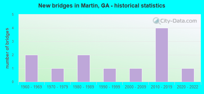
- New bridges - historical statistics
- 21960-1969
- 11970-1979
- 21980-1989
- 11990-1999
- 12000-2009
- 42010-2019
- 12020-2022


- Bridge Condition - Deck
- 33.3%Very good
- 66.7%Good

- Bridge Condition - Superstructure
- 50.0%Very good
- 50.0%Good

- Bridge Condition - Substructure
- 33.3%Very good
- 66.7%Good

- Bridge Condition - Channel
- 10.0%Excellent
- 30.0%Very good
- 30.0%Good
- 10.0%Satisfactory
- 20.0%Fair

- Bridge Condition - Culverts
- 16.7%Very good
- 83.3%Good
Find on map >> Show street view
Structure Number: 1195016, Location: 6 MI W OF LAVONIA (Lat: 34.445189, Lng: -83.212128), Route carried "on" structure: County highway 101, Year Built: 1963, Status: Posted for load, Structure Length: 4.57m (14.99ft), Average Daily Traffic: 470 (year 2011), Truck Traffic: 1%, Average Future Daily Traffic: 705 (year 2031), Design Load: H 15, Features Intersected: NORTH FORK BROAD RIVER, Facility Carried by Structure: CLARK'S CREEK RD
Minimum Vertical Clearance: 30+ m (98+ ft), Kilometerpoint: 3.219, Lanes on structure: 2, Base Highway Network: Yes, Owner: County Highway Agency, Approaching Roadway Width: 6.1m (20.0ft), Material/Design: Concrete, Design/Construction: Tee Beam, Number Of Spans In Main Unit: 5, Length of Maximum Span: 9.1m (29.9ft), Curb or Sidewalk Widths: Left: 0.6m (2.0ft), Right: 0.6m (2.0ft), Curb-To-Curb Width: 7.3m (24.0ft), Out-to-Out Width: 9.1m (29.9ft)
Condition: Deck: Good, Superstructure: Good, Substructure: Good, Channel: Good, Operating Rating: 30.8 metric tons, Method Used To Determine Operating Rating: Load Factor (LF), Inventory Rating: 18.1 metric tons, Method Used To Determine Inventory Rating: Load Factor (LF), Structural Evaluation: Somewhat better than minimum adequacy, Deck Geometry: Meets minimum limits, Waterway Adequacy: Superior to present desirable criteria, Approach Roadway Alignment: Better than present minimum criteria, Bridge Posting: Required (Relationship of Operating Rating to Maximum Legal Load: 0.1 - 9.9% below), Designated Inspection Frequency: Every 24 months, Inspection Date: August 2020, Bridge Improvement Cost: $586,000, Roadway Improvement Cost: $59,000, Total Project Cost: $879,000, Deck Structure Type: Concrete Cast-file-Place
Find on map >> Show street view
Structure Number: 1195019, Location: 5.4 MI NW OF LAVONIA (Lat: 34.459039, Lng: -83.198428), Route carried "on" structure: County highway 107, Year Built: 1989, Status: Open, Structure Length: 0.73m (2.40ft), Average Daily Traffic: 60 (year 2011), Truck Traffic: 1%, Average Future Daily Traffic: 90 (year 2031), Design Load: H 15, Features Intersected: CLARKS CREEK, Facility Carried by Structure: FREEMAN ROAD
Minimum Vertical Clearance: 30+ m (98+ ft), Kilometerpoint: 1.609, Lanes on structure: 2, Base Highway Network: Yes, Owner: County Highway Agency, Approaching Roadway Width: 4.3m (14.1ft), Material/Design: Steel, Design/Construction: Culvert, Number Of Spans In Main Unit: 3, Length of Maximum Span: 1.8m (5.9ft)
Condition: Channel: Satisfactory, Culverts: Good, Operating Rating: 41.7 metric tons, Method Used To Determine Operating Rating: Field evaluation and documented engineering judgment, Inventory Rating: 24.4 metric tons, Method Used To Determine Inventory Rating: Field evaluation and documented engineering judgment, Structural Evaluation: Equal to present minimum criteria, Waterway Adequacy: Equal to present desirable criteria, Approach Roadway Alignment: Somewhat better than minimum adequacy, Designated Inspection Frequency: Every 24 months, Inspection Date: September 2020, Bridge Improvement Cost: $94,000, Roadway Improvement Cost: $9,000, Total Project Cost: $141,000
Find on map >> Show street view
Structure Number: 119502, Location: 5.3 MI NW OF LAVONIA (Lat: 34.446089, Lng: -83.198408), Route carried "on" structure: County highway 108, Year Built: 1963, Status: Open, Structure Length: 1.04m (3.41ft), Average Daily Traffic: 470 (year 2011), Truck Traffic: 1%, Average Future Daily Traffic: 705 (year 2031), Design Load: H 15, Features Intersected: CLARKS CREEK, Facility Carried by Structure: CLARKS CREEK ROAD
Minimum Vertical Clearance: 30+ m (98+ ft), Kilometerpoint: 4.828, Lanes on structure: 2, Base Highway Network: Yes, Owner: County Highway Agency, Approaching Roadway Width: 6.4m (21.0ft), Skew: 2 degrees, Material/Design: Concrete, Design/Construction: Culvert, Number Of Spans In Main Unit: 3, Length of Maximum Span: 3.4m (11.2ft)
Condition: Channel: Fair, Culverts: Good, Operating Rating: 41.7 metric tons, Method Used To Determine Operating Rating: Field evaluation and documented engineering judgment, Inventory Rating: 24.4 metric tons, Method Used To Determine Inventory Rating: Field evaluation and documented engineering judgment, Structural Evaluation: Equal to present minimum criteria, Waterway Adequacy: Superior to present desirable criteria, Approach Roadway Alignment: Somewhat better than minimum adequacy, Designated Inspection Frequency: Every 24 months, Inspection Date: September 2020, Bridge Improvement Cost: $133,000, Roadway Improvement Cost: $13,000, Total Project Cost: $199,000
Find on map >> Show street view
Structure Number: 1195092, Location: 7 MI N.W. OF LAVONIA (Lat: 34.448058, Lng: -83.227778), Route carried "on" structure: State highway 145, Year Built: 2001, Status: Open, Structure Length: 4.85m (15.91ft), Average Daily Traffic: 1,000 (year 2011), Truck Traffic: 12%, Average Future Daily Traffic: 1,500 (year 2031), Design Load: HS 20+Mod, Features Intersected: NORTH FORK BROAD RIVER
Minimum Vertical Clearance: 30+ m (98+ ft), Kilometerpoint: 22.531, Lanes on structure: 2, Base Highway Network: Yes, Owner: State Highway Agency, Approaching Roadway Width: 7.6m (24.9ft), Skew: 2 degrees, Material/Design: Prestressed concrete, Design/Construction: Stringer/Multi-beam, Number Of Spans In Main Unit: 3, Length of Maximum Span: 30.5m (100.1ft), Curb-To-Curb Width: 11.6m (38.1ft), Out-to-Out Width: 12.6m (41.3ft)
Condition: Deck: Good, Superstructure: Very good, Substructure: Good, Channel: Good, Operating Rating: 53.5 metric tons, Method Used To Determine Operating Rating: Load Factor (LF), Inventory Rating: 31.7 metric tons, Method Used To Determine Inventory Rating: Load Factor (LF), Structural Evaluation: Better than present minimum criteria, Deck Geometry: Better than present minimum criteria, Waterway Adequacy: Equal to present desirable criteria, Approach Roadway Alignment: Equal to present minimum criteria, Designated Inspection Frequency: Every 24 months, Inspection Date: September 2020, Bridge Improvement Cost: $621,000, Roadway Improvement Cost: $62,000, Total Project Cost: $932,000, Deck Structure Type: Concrete Cast-file-Place
Find on map >> Show street view
Structure Number: 1195109, Location: 7 MI NW OF LAVONIA (Lat: 34.463158, Lng: -83.224689), Route carried "on" structure: County highway 103, Year Built: 2013, Status: Open, Structure Length: 0.98m (3.22ft), Average Daily Traffic: 100 (year 2011), Truck Traffic: 1%, Average Future Daily Traffic: 150 (year 2031), Design Load: HS 20, Features Intersected: TOMS CREEK
Minimum Vertical Clearance: 30+ m (98+ ft), Kilometerpoint: 1.609, Lanes on structure: 1, Base Highway Network: Yes, Owner: County Highway Agency, Approaching Roadway Width: 4.6m (15.1ft), Skew: 1 degrees, Material/Design: Concrete, Design/Construction: Culvert, Number Of Spans In Main Unit: 3, Length of Maximum Span: 3.0m (9.8ft)
Condition: Channel: Very good, Culverts: Very good, Operating Rating: 85.2 metric tons, Method Used To Determine Operating Rating: Load Factor (LF), Inventory Rating: 50.8 metric tons, Method Used To Determine Inventory Rating: Load Factor (LF), Structural Evaluation: Equal to present desirable criteria, Waterway Adequacy: Equal to present desirable criteria, Approach Roadway Alignment: Equal to present minimum criteria, Length Of Structure Improvement: 1.17m (3.84ft), Designated Inspection Frequency: Every 24 months, Inspection Date: September 2020, Bridge Improvement Cost: $2,841,000, Roadway Improvement Cost: $284,000, Total Project Cost: $4,262,000 ( Estimate for 2014)
Find on map >> Show street view
Structure Number: 119511, Location: 3 MI WEST OF LAVONIA (Lat: 34.475881, Lng: -83.176900), Route carried "on" structure: State highway 17, Year Built: 2015, Status: Open, Structure Length: 14.39m (47.21ft), Average Daily Traffic: 10,200 (year 2015), Truck Traffic: 14%, Average Future Daily Traffic: 15,940 (year 2035), Design Load: HS 20+Mod, Features Intersected: EAST MAIN ST (HART R/R)
Minimum Vertical Clearance: 30+ m (98+ ft), Kilometerpoint: 25.750, Lanes on structure: 2, Lanes under structure: 2, Owner: State Highway Agency, Approaching Roadway Width: 11.6m (38.1ft), Skew: 4 degrees, Material/Design: Prestressed concrete, Design/Construction: Stringer/Multi-beam, Number Of Spans In Main Unit: 4, Length of Maximum Span: 38.7m (127.0ft), Curb-To-Curb Width: 11.6m (38.1ft), Out-to-Out Width: 12.5m (41.0ft)
Condition: Deck: Good, Superstructure: Good, Substructure: Good, Operating Rating: 61.6 metric tons, Method Used To Determine Operating Rating: Load Factor (LF), Inventory Rating: 36.2 metric tons, Method Used To Determine Inventory Rating: Load Factor (LF), Structural Evaluation: Better than present minimum criteria, Deck Geometry: Better than present minimum criteria, Underclear: Superior to present desirable criteria, Approach Roadway Alignment: Better than present minimum criteria, Length Of Structure Improvement: 9.91m (32.51ft), Designated Inspection Frequency: Every 24 months, Inspection Date: October 2020, Bridge Improvement Cost: $24,050,000, Roadway Improvement Cost: $2,405,000, Total Project Cost: $36,075,000 ( Estimate for 2017), Deck Structure Type: Concrete Cast-file-Place
Find on map >> Show street view
Structure Number: 1195111, Location: 3 MI WEST OF LAVONIA (Lat: 34.475881, Lng: -83.176900), Route carried "on" structure: State highway 17, Year Built: 2015, Status: Open, Structure Length: 14.39m (47.21ft), Average Daily Traffic: 10,200 (year 2015), Truck Traffic: 14%, Average Future Daily Traffic: 16,940 (year 2035), Design Load: HS 20+Mod, Features Intersected: EAST MAIN ST (HART R/R)
Minimum Vertical Clearance: 30+ m (98+ ft), Kilometerpoint: 25.750, Lanes on structure: 2, Lanes under structure: 2, Owner: State Highway Agency, Approaching Roadway Width: 11.6m (38.1ft), Skew: 4 degrees, Material/Design: Prestressed concrete, Design/Construction: Stringer/Multi-beam, Number Of Spans In Main Unit: 4, Length of Maximum Span: 38.7m (127.0ft), Curb-To-Curb Width: 11.6m (38.1ft), Out-to-Out Width: 12.5m (41.0ft)
Condition: Deck: Good, Superstructure: Good, Substructure: Good, Operating Rating: 58.9 metric tons, Method Used To Determine Operating Rating: Load Factor (LF), Inventory Rating: 35.3 metric tons, Method Used To Determine Inventory Rating: Load Factor (LF), Structural Evaluation: Better than present minimum criteria, Deck Geometry: Better than present minimum criteria, Underclear: Superior to present desirable criteria, Approach Roadway Alignment: Better than present minimum criteria, Length Of Structure Improvement: 9.91m (32.51ft), Designated Inspection Frequency: Every 24 months, Inspection Date: October 2020, Bridge Improvement Cost: $24,050,000, Roadway Improvement Cost: $2,405,000, Total Project Cost: $36,075,000 ( Estimate for 2017), Deck Structure Type: Concrete Cast-file-Place
Find on map >> Show street view
Structure Number: 1195115, Location: 7.3 MI NW OF CARNESVILLE (Lat: 34.470939, Lng: -83.271039), Route carried "on" structure: County highway 205, Year Built: 2019, Status: Open, Structure Length: 4.57m (14.99ft), Average Daily Traffic: 320 (year 2020), Truck Traffic: 1%, Average Future Daily Traffic: 390 (year 2040), Design Load: HL 93, Features Intersected: NORTH FORK BROAD RIVER, Facility Carried by Structure: AKINS BRIDGE ROAD
Minimum Vertical Clearance: 30+ m (98+ ft), Kilometerpoint: 1.609, Lanes on structure: 2, Base Highway Network: Yes, Owner: County Highway Agency, Approaching Roadway Width: 7.3m (24.0ft), Skew: 3 degrees, Material/Design: Prestressed concrete, Design/Construction: Stringer/Multi-beam, Number Of Spans In Main Unit: 3, Length of Maximum Span: 15.2m (49.9ft), Curb-To-Curb Width: 7.3m (24.0ft), Out-to-Out Width: 8.3m (27.2ft)
Condition: Deck: Very good, Superstructure: Very good, Substructure: Very good, Channel: Excellent, Operating Rating: 76.2 metric tons, Method Used To Determine Operating Rating: Load Factor (LF), Inventory Rating: 44.4 metric tons, Method Used To Determine Inventory Rating: Load Factor (LF), Structural Evaluation: Equal to present desirable criteria, Deck Geometry: Somewhat better than minimum adequacy, Waterway Adequacy: Equal to present desirable criteria, Approach Roadway Alignment: Better than present minimum criteria, Length Of Structure Improvement: 5.49m (18.01ft), Designated Inspection Frequency: Every 24 months, Inspection Date: October 2020, Bridge Improvement Cost: $13,320,000, Roadway Improvement Cost: $1,332,000, Total Project Cost: $19,980,000 ( Estimate for 2020), Deck Structure Type: Concrete Cast-file-Place
Find on map >> Show street view
Structure Number: 1195118, Location: 5.7 MI N OF CARNESVILLE (Lat: 34.452428, Lng: -83.239508), Route carried "on" structure: County highway 145, Year Built: 2021, Status: Open, Structure Length: 5.33m (17.49ft), Average Daily Traffic: 75 (year 2021), Truck Traffic: 1%, Average Future Daily Traffic: 100 (year 2041), Design Load: HL 93, Features Intersected: NORTH FORK BROAD RIVER, Facility Carried by Structure: CRUMPS BRIDGE ROAD
Minimum Vertical Clearance: 30+ m (98+ ft), Kilometerpoint: 0.000, Lanes on structure: 2, Base Highway Network: Yes, Owner: County Highway Agency, Approaching Roadway Width: 8.2m (26.9ft), Material/Design: Prestressed concrete, Design/Construction: Box Beam or Girders - Multiple, Number Of Spans In Main Unit: 3, Length of Maximum Span: 29.0m (95.1ft), Curb-To-Curb Width: 8.2m (26.9ft), Out-to-Out Width: 9.1m (29.9ft)
Condition: Deck: Very good, Superstructure: Very good, Substructure: Very good, Channel: Very good, Operating Rating: 76.2 metric tons, Method Used To Determine Operating Rating: Load Factor (LF), Inventory Rating: 23.5 metric tons, Method Used To Determine Inventory Rating: Load Factor (LF), Structural Evaluation: Equal to present minimum criteria, Deck Geometry: Equal to present minimum criteria, Waterway Adequacy: Superior to present desirable criteria, Approach Roadway Alignment: Equal to present desirable criteria, Length Of Structure Improvement: 6.40m (21.00ft), Designated Inspection Frequency: Every 24 months, Inspection Date: July 2021, Bridge Improvement Cost: $15,540,000, Roadway Improvement Cost: $1,554,000, Total Project Cost: $23,310,000 ( Estimate for 2021), Deck Structure Type: Concrete Cast-file-Place, Wearing Surface/Protective System: Wearing Surface: Bituminous
Find on map >> Show street view
Structure Number: 2575001, Location: 2.8 MI SW OF AVALON (Lat: 34.487997, Lng: -83.239958), Route carried "on" structure: County highway 13, Year Built: 1975, Status: Open, Structure Length: 0.64m (2.10ft), Average Daily Traffic: 600 (year 2011), Truck Traffic: 1%, Average Future Daily Traffic: 900 (year 2031), Design Load: HS 20+Mod, Features Intersected: BIG TOMS CREEK, Facility Carried by Structure: McCURLEY ROAD
Minimum Vertical Clearance: 30+ m (98+ ft), Kilometerpoint: 6.437, Lanes on structure: 2, Base Highway Network: Yes, Owner: County Highway Agency, Approaching Roadway Width: 6.4m (21.0ft), Material/Design: Concrete, Design/Construction: Culvert, Number Of Spans In Main Unit: 2, Length of Maximum Span: 3.0m (9.8ft)
Condition: Channel: Fair, Culverts: Good, Operating Rating: 55.3 metric tons, Method Used To Determine Operating Rating: Field evaluation and documented engineering judgment, Inventory Rating: 32.6 metric tons, Method Used To Determine Inventory Rating: Field evaluation and documented engineering judgment, Structural Evaluation: Better than present minimum criteria, Waterway Adequacy: Superior to present desirable criteria, Approach Roadway Alignment: Better than present minimum criteria, Designated Inspection Frequency: Every 24 months, Inspection Date: January 2021, Bridge Improvement Cost: $82,000, Roadway Improvement Cost: $8,000, Total Project Cost: $123,000
Find on map >> Show street view
Structure Number: 2575002, Location: 2.4 MI SW OF AVALON (Lat: 34.483458, Lng: -83.233978), Route carried "on" structure: County highway 16, Year Built: 1988, Status: Open, Structure Length: 1.01m (3.31ft), Average Daily Traffic: 710 (year 2011), Truck Traffic: 1%, Average Future Daily Traffic: 1,065 (year 2031), Design Load: HS 20+Mod, Features Intersected: BIG TOMS CREEK, Facility Carried by Structure: AVALON ROAD
Minimum Vertical Clearance: 30+ m (98+ ft), Kilometerpoint: 1.609, Lanes on structure: 2, Base Highway Network: Yes, Owner: County Highway Agency, Approaching Roadway Width: 6.4m (21.0ft), Skew: 1 degrees, Material/Design: Concrete, Design/Construction: Culvert, Number Of Spans In Main Unit: 3, Length of Maximum Span: 3.0m (9.8ft)
Condition: Channel: Very good, Culverts: Good, Operating Rating: 55.3 metric tons, Method Used To Determine Operating Rating: Field evaluation and documented engineering judgment, Inventory Rating: 32.6 metric tons, Method Used To Determine Inventory Rating: Field evaluation and documented engineering judgment, Structural Evaluation: Better than present minimum criteria, Waterway Adequacy: Equal to present desirable criteria, Approach Roadway Alignment: Equal to present minimum criteria, Designated Inspection Frequency: Every 24 months, Inspection Date: January 2021, Bridge Improvement Cost: $129,000, Roadway Improvement Cost: $13,000, Total Project Cost: $193,000
Find on map >> Show street view
Structure Number: 2575027, Location: 4.3 MI SW OF AVALON (Lat: 34.487250, Lng: -83.267547), Route carried "on" structure: County highway 215, Year Built: 1992, Status: Open, Structure Length: 0.73m (2.40ft), Average Daily Traffic: 600 (year 2011), Truck Traffic: 1%, Average Future Daily Traffic: 900 (year 2031), Design Load: H 15, Features Intersected: MAG CREEK, Facility Carried by Structure: KAY ROAD
Minimum Vertical Clearance: 30+ m (98+ ft), Kilometerpoint: 1.609, Lanes on structure: 2, Base Highway Network: Yes, Owner: County Highway Agency, Approaching Roadway Width: 6.1m (20.0ft), Material/Design: Steel, Design/Construction: Culvert, Number Of Spans In Main Unit: 3, Length of Maximum Span: 1.8m (5.9ft)
Condition: Channel: Good, Culverts: Good, Operating Rating: 41.7 metric tons, Method Used To Determine Operating Rating: Field evaluation and documented engineering judgment, Inventory Rating: 24.4 metric tons, Method Used To Determine Inventory Rating: Field evaluation and documented engineering judgment, Structural Evaluation: Equal to present minimum criteria, Waterway Adequacy: Better than present minimum criteria, Approach Roadway Alignment: Equal to present minimum criteria, Designated Inspection Frequency: Every 24 months, Inspection Date: Febuary 2021, Bridge Improvement Cost: $94,000, Roadway Improvement Cost: $9,000, Total Project Cost: $141,000
Find on map >> Show street view
Structure Number: 119511, Location: 3 MI WEST OF LAVONIA (Lat: 34.475881, Lng: -83.176900), Route carried "under" structure: County highway 99999, Structure Length: 0. m, Truck Traffic: 1%, Features Intersected: SR17, Facility Carried by Structure: SR17 (NBL)
Minimum Vertical Clearance: 9.93m (32.58ft), Kilometerpoint: 0.000, Lanes on structure: 2, Length of Maximum Span: 0.0m
Find on map >> Show street view
Structure Number: 1195111, Location: 3 MI WEST OF LAVONIA (Lat: 34.475881, Lng: -83.176900), Route carried "under" structure: County highway 99999, Structure Length: 0. m, Truck Traffic: 1%, Features Intersected: SR 17, Facility Carried by Structure: SR 17 (SBL)
Minimum Vertical Clearance: 10.08m (33.07ft), Kilometerpoint: 0.000, Lanes on structure: 2, Length of Maximum Span: 0.0m