Bridge Statistics for Mayflower, Arkansas (AR)
Condition, Traffic, Stress, Structural Evaluation, Project Costs
- National Bridge Inventory (NBI) Statistics
- 28Number of bridges
- 200ft / 60.6mTotal length
- $3,589,000Total costs
- 345,169Total average daily traffic
- 45,020Total average daily truck traffic
- National Bridge Inventory (NBI) Registered Bridges for Mayflower
- No street view available for this location
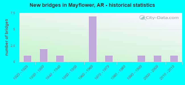
- New bridges - historical statistics
- 11920-1929
- 21930-1939
- 11940-1949
- 71960-1969
- 11970-1979
- 11990-1999
- 12000-2009
- 12010-2019

- Reconstructed bridges - Historical Statistics
- 21970-1979
- 01980-1989
- 01990-1999
- 42000-2009


- Bridge Condition - Deck
- 38.5%Good
- 53.8%Satisfactory
- 7.7%Poor

- Bridge Condition - Superstructure
- 38.5%Good
- 53.8%Satisfactory
- 7.7%Fair

- Bridge Condition - Substructure
- 46.2%Good
- 46.2%Satisfactory
- 7.7%Fair

- Bridge Condition - Channel
- 20.0%Very good
- 50.0%Good
- 30.0%Satisfactory

- Bridge Condition - Culverts
- 50.0%Good
- 50.0%Satisfactory
Find on map >> Show street view
Structure Number: 1535, Location: 5.5 Miles East Jct Sh 78 (Lat: 34.939836, Lng: -91.015572), Route carried "on" structure: US 70, Year Built: 1930, Status: Open, Structure Length: 2.10m (6.89ft), Average Daily Traffic: 1,209 (year 2018), Truck Traffic: 1%, Average Future Daily Traffic: 1,210 (year 2028), Design Load: H 15, Features Intersected: Big Creek
Minimum Vertical Clearance: 30+ m (98+ ft), Kilometerpoint: 9.849, Lanes on structure: 2, Owner: State Highway Agency, Approaching Roadway Width: 8.2m (26.9ft), Material/Design: Concrete, Design/Construction: Tee Beam, Number Of Spans In Main Unit: 2, Length of Maximum Span: 10.5m (34.4ft), Curb or Sidewalk Widths: Left: 0.5m (1.6ft), Right: 0.5m (1.6ft), Curb-To-Curb Width: 8.2m (26.9ft), Out-to-Out Width: 9.1m (29.9ft)
Condition: Deck: Good, Superstructure: Satisfactory, Substructure: Satisfactory, Channel: Good, Operating Rating: 39.9 metric tons, Method Used To Determine Operating Rating: Load Factor (LF), Inventory Rating: 24.5 metric tons, Method Used To Determine Inventory Rating: Load Factor (LF), Structural Evaluation: Equal to present minimum criteria, Deck Geometry: Meets minimum limits, Waterway Adequacy: Equal to present desirable criteria, Approach Roadway Alignment: Equal to present desirable criteria, Designated Inspection Frequency: Every 24 months, Critical Feature Inspection Frequency: Every 24 months, Inspection Date: January 2022, Deck Structure Type: Concrete Cast-file-Place, Wearing Surface/Protective System: Wearing Surface: Bituminous
Find on map >> Show street view
Structure Number: 3787, Location: 11.14 MI W PULASKI CO LI (Lat: 34.970639, Lng: -92.418700), Route carried "on" structure: State highway 89, Year Built: 1966, Status: Open, Structure Length: 6.95m (22.80ft), Average Daily Traffic: 8,300 (year 2018), Truck Traffic: 1%, Average Future Daily Traffic: 8,266 (year 2028), Design Load: HS 20, Features Intersected: I 40-SEC 32
Minimum Vertical Clearance: 30+ m (98+ ft), Kilometerpoint: 17.923, Lanes on structure: 2, Lanes under structure: 6, Owner: State Highway Agency, Approaching Roadway Width: 9.4m (30.8ft), Skew: 2 degrees, Material/Design: Steel, Design/Construction: Stringer/Multi-beam, Number Of Spans In Main Unit: 4, Length of Maximum Span: 21.3m (69.9ft), Curb-To-Curb Width: 8.5m (27.9ft), Out-to-Out Width: 10.2m (33.5ft)
Condition: Deck: Poor, Superstructure: Satisfactory, Substructure: Fair, Operating Rating: 54.4 metric tons, Method Used To Determine Operating Rating: Load Factor (LF), Inventory Rating: 32.7 metric tons, Method Used To Determine Inventory Rating: Load Factor (LF), Structural Evaluation: Somewhat better than minimum adequacy, Deck Geometry: Meets minimum limits, Underclear: High priority of corrective action, Approach Roadway Alignment: Equal to present desirable criteria, Designated Inspection Frequency: Every 24 months, Critical Feature Inspection Frequency: Every 24 months, Inspection Date: January 2022, Deck Structure Type: Concrete Cast-file-Place, Wearing Surface/Protective System: Wearing Surface: Monolithic Concrete
Find on map >> Show street view
Structure Number: 3852, Location: 1.0 MI NORTH OF SH 89 (Lat: 34.982831, Lng: -92.416261), Route carried "on" structure: County highway 19, Year Built: 1966, Status: Open, Structure Length: 6.46m (21.19ft), Average Daily Traffic: 1,300 (year 2018), Truck Traffic: 1%, Average Future Daily Traffic: 600 (year 2007), Design Load: H 15, Features Intersected: I 40-SEC 32, Facility Carried by Structure: Paradise Rd
Minimum Vertical Clearance: 30+ m (98+ ft), Kilometerpoint: 0.161, Lanes on structure: 2, Lanes under structure: 4, Owner: State Highway Agency, Approaching Roadway Width: 7.9m (25.9ft), Material/Design: Steel, Design/Construction: Stringer/Multi-beam, Number Of Spans In Main Unit: 4, Length of Maximum Span: 20.1m (65.9ft), Curb-To-Curb Width: 7.3m (24.0ft), Out-to-Out Width: 8.7m (28.5ft)
Condition: Deck: Satisfactory, Superstructure: Fair, Substructure: Satisfactory, Operating Rating: 40.8 metric tons, Method Used To Determine Operating Rating: Load Factor (LF), Inventory Rating: 24.5 metric tons, Method Used To Determine Inventory Rating: Load Factor (LF), Structural Evaluation: Somewhat better than minimum adequacy, Deck Geometry: Meets minimum limits, Underclear: High priority of corrective action, Approach Roadway Alignment: Equal to present desirable criteria, Designated Inspection Frequency: Every 24 months, Critical Feature Inspection Frequency: Every 24 months, Inspection Date: Febuary 2022, Deck Structure Type: Concrete Cast-file-Place, Wearing Surface/Protective System: Wearing Surface: Monolithic Concrete
Find on map >> Show street view
Structure Number: 4864, Location: 0.6 MI E JCT SH 365 (Lat: 34.938819, Lng: -92.419000), Route carried "on" structure: County highway 663, Year Built: 2003, Status: Open, Structure Length: 5.24m (17.19ft), Average Daily Traffic: 170 (year 2018), Average Future Daily Traffic: 22 (year 2006), Design Load: HS 20, Features Intersected: Palarm Creek, Facility Carried by Structure: Grassy Lake Rd - A
Minimum Vertical Clearance: 30+ m (98+ ft), Kilometerpoint: 0.917, Lanes on structure: 2, Owner: County Highway Agency, Approaching Roadway Width: 7.6m (24.9ft), Material/Design: Steel, Design/Construction: Orthotropic, Number Of Spans In Main Unit: 6, Length of Maximum Span: 12.2m (40.0ft), Curb-To-Curb Width: 7.3m (24.0ft), Out-to-Out Width: 8.0m (26.2ft)
Condition: Deck: Good, Superstructure: Satisfactory, Substructure: Good, Channel: Good, Operating Rating: 54.4 metric tons, Method Used To Determine Operating Rating: Load Factor (LF), Inventory Rating: 32.7 metric tons, Method Used To Determine Inventory Rating: Load Factor (LF), Structural Evaluation: Equal to present minimum criteria, Deck Geometry: Somewhat better than minimum adequacy, Waterway Adequacy: Equal to present desirable criteria, Approach Roadway Alignment: Equal to present desirable criteria, Designated Inspection Frequency: Every 24 months, Critical Feature Inspection Frequency: Every 24 months, Inspection Date: December 2021, Critical Feature Inspection Date: December 2021, Deck Structure Type: Steel plate, Wearing Surface/Protective System: Wearing Surface: Bituminous
Find on map >> Show street view
Structure Number: 5143, Location: 9.94 MI W PULASKI CO L (Lat: 34.968950, Lng: -92.402611), Route carried "on" structure: State highway 89, Year Built: 1968, Status: Open, Structure Length: 5.49m (18.01ft), Average Daily Traffic: 6,100 (year 2018), Truck Traffic: 1%, Average Future Daily Traffic: 6,091 (year 2028), Design Load: H 15, Features Intersected: Lake Conway
Minimum Vertical Clearance: 30+ m (98+ ft), Kilometerpoint: 15.994, Lanes on structure: 2, Owner: State Highway Agency, Approaching Roadway Width: 7.9m (25.9ft), Material/Design: Concrete, Design/Construction: Slab, Number Of Spans In Main Unit: 6, Length of Maximum Span: 9.1m (29.9ft), Curb-To-Curb Width: 7.3m (24.0ft), Out-to-Out Width: 8.5m (27.9ft)
Condition: Deck: Good, Superstructure: Good, Substructure: Satisfactory, Channel: Good, Operating Rating: 39.0 metric tons, Method Used To Determine Operating Rating: Load Factor (LF), Inventory Rating: 23.6 metric tons, Method Used To Determine Inventory Rating: Load Factor (LF), Structural Evaluation: Somewhat better than minimum adequacy, Deck Geometry: High priority of replacement, Waterway Adequacy: Equal to present desirable criteria, Approach Roadway Alignment: Equal to present minimum criteria, Length Of Structure Improvement: 6.43m (21.10ft), Designated Inspection Frequency: Every 24 months, Critical Feature Inspection Frequency: Every 24 months, Inspection Date: Febuary 2022, Roadway Improvement Cost: $125,000, Total Project Cost: $508,000, Deck Structure Type: Concrete Cast-file-Place, Wearing Surface/Protective System: Wearing Surface: Monolithic Concrete
Find on map >> Show street view
Structure Number: 12966, Location: .14 S SH 89 (Lat: 34.960408, Lng: -92.458656), Route carried "on" structure: County highway 2, Year Built: 1939, Status: Open, Structure Length: 0.67m (2.20ft), Average Daily Traffic: 1,506 (year 2018), Truck Traffic: 1%, Average Future Daily Traffic: 44 (year 2007), Features Intersected: Creek, Facility Carried by Structure: Easterwood Rd
Minimum Vertical Clearance: 30+ m (98+ ft), Kilometerpoint: 0.209, Lanes on structure: 2, Owner: County Highway Agency, Approaching Roadway Width: 6.4m (21.0ft), Material/Design: Concrete, Design/Construction: Slab, Number Of Spans In Main Unit: 2, Length of Maximum Span: 3.4m (11.2ft), Curb-To-Curb Width: 6.1m (20.0ft), Out-to-Out Width: 6.4m (21.0ft)
Condition: Deck: Good, Superstructure: Good, Substructure: Satisfactory, Channel: Good, Operating Rating: 34.5 metric tons, Method Used To Determine Operating Rating: Load Factor (LF), Inventory Rating: 20.9 metric tons, Method Used To Determine Inventory Rating: Load Factor (LF), Structural Evaluation: Somewhat better than minimum adequacy, Deck Geometry: High priority of replacement, Waterway Adequacy: Equal to present minimum criteria, Approach Roadway Alignment: Equal to present minimum criteria, Designated Inspection Frequency: Every 24 months, Critical Feature Inspection Frequency: Every 24 months, Inspection Date: June 2021, Deck Structure Type: Concrete Cast-file-Place, Wearing Surface/Protective System: Wearing Surface: Bituminous
Find on map >> Show street view
Structure Number: 17939, Location: 1.25MI N SH 89 (Lat: 34.976050, Lng: -92.346661), Route carried "on" structure: County highway 51, Year Built: 1975, Status: Open, Structure Length: 0.88m (2.89ft), Average Daily Traffic: 1,600 (year 2018), Truck Traffic: 1%, Average Future Daily Traffic: 734 (year 2007), Features Intersected: Chadwick Creek, Facility Carried by Structure: Clinton Rd
Minimum Vertical Clearance: 30+ m (98+ ft), Kilometerpoint: 14.046, Lanes on structure: 2, Owner: County Highway Agency, Approaching Roadway Width: 6.4m (21.0ft), Material/Design: Steel, Design/Construction: Culvert, Number Of Spans In Main Unit: 4, Length of Maximum Span: 1.5m (4.9ft)
Condition: Channel: Satisfactory, Culverts: Satisfactory, Operating Rating: 54.4 metric tons, Method Used To Determine Operating Rating: Load Factor (LF), Inventory Rating: 32.7 metric tons, Method Used To Determine Inventory Rating: Load Factor (LF), Structural Evaluation: Equal to present minimum criteria, Waterway Adequacy: Somewhat better than minimum adequacy, Approach Roadway Alignment: Equal to present desirable criteria, Designated Inspection Frequency: Every 24 months, Critical Feature Inspection Frequency: Every 24 months, Inspection Date: June 2021
Find on map >> Show street view
Structure Number: 24198, Location: 3/4 miles SW of SH 365 (Lat: 34.923436, Lng: -92.447128), Route carried "on" structure: County highway , Year Built: 1998, Status: Open, Structure Length: 5.18m (16.99ft), Average Daily Traffic: 250 (year 2021), Average Future Daily Traffic: 300 (year 2041), Features Intersected: Union Pacific Railroad, Facility Carried by Structure: Plantation Drive
Minimum Vertical Clearance: 30+ m (98+ ft), Kilometerpoint: 1.223, Lanes on structure: 2, Owner: County Highway Agency, Approaching Roadway Width: 6.7m (22.0ft), Material/Design: Steel, Design/Construction: Stringer/Multi-beam, Number Of Spans In Main Unit: 3, Length of Maximum Span: 22.3m (73.2ft), Curb or Sidewalk Widths: Left: 2.7m (8.9ft), Right: 0.0m, Curb-To-Curb Width: 6.1m (20.0ft), Out-to-Out Width: 10.1m (33.1ft)
Condition: Deck: Good, Superstructure: Good, Substructure: Good, Operating Rating: 54.4 metric tons, Method Used To Determine Operating Rating: Load Factor (LF), Inventory Rating: 32.7 metric tons, Method Used To Determine Inventory Rating: Load Factor (LF), Structural Evaluation: Better than present minimum criteria, Deck Geometry: Meets minimum limits, Underclear: Superior to present desirable criteria, Approach Roadway Alignment: Somewhat better than minimum adequacy, Designated Inspection Frequency: Every 24 months, Critical Feature Inspection Frequency: Every 24 months, Inspection Date: August 2021, Deck Structure Type: Concrete Cast-file-Place
Find on map >> Show street view
Structure Number: A3667, Location: 0.53 MI NO PULASKI CO LIN (Lat: 34.937211, Lng: -92.419781), Route carried "on" structure: Interstate 40, Year Built: 1965, Year Reconstructed: 2000, Status: Open, Structure Length: 9.68m (31.76ft), Average Daily Traffic: 35,356 (year 2013), Truck Traffic: 21%, Average Future Daily Traffic: 45,679 (year 2028), Design Load: HS 20+Mod, Features Intersected: UNK CO RD,PALARM CR
Minimum Vertical Clearance: 30+ m (98+ ft), Kilometerpoint: 221.816, Lanes on structure: 3, Lanes under structure: 2, Base Highway Network: Yes, Owner: State Highway Agency, Approaching Roadway Width: 18.3m (60.0ft), Material/Design: Steel continuous, Design/Construction: Stringer/Multi-beam, Number Of Spans In Main Unit: 7, Length of Maximum Span: 13.7m (44.9ft), Curb-To-Curb Width: 17.1m (56.1ft), Out-to-Out Width: 18.0m (59.1ft)
Condition: Deck: Satisfactory, Superstructure: Good, Substructure: Good, Channel: Very good, Operating Rating: 54.4 metric tons, Method Used To Determine Operating Rating: Load Factor (LF), Inventory Rating: 32.7 metric tons, Method Used To Determine Inventory Rating: Load Factor (LF), Structural Evaluation: Better than present minimum criteria, Deck Geometry: Equal to present minimum criteria, Underclear: Somewhat better than minimum adequacy, Waterway Adequacy: Equal to present desirable criteria, Approach Roadway Alignment: Equal to present desirable criteria, Length Of Structure Improvement: 10.79m (35.40ft), Designated Inspection Frequency: Every 24 months, Critical Feature Inspection Frequency: Every 24 months, Inspection Date: September 2020, Roadway Improvement Cost: $247,000, Total Project Cost: $1,236,000, Deck Structure Type: Concrete Cast-file-Place, Wearing Surface/Protective System: Wearing Surface: Monolithic Concrete, Deck Protection: Epoxy Coated Reinforcing
Find on map >> Show street view
Structure Number: A3696, Location: 0.53 MI NO PULASKI CO (Lat: 34.939419, Lng: -92.421139), Route carried "on" structure: Interstate 40, Year Built: 1965, Year Reconstructed: 2000, Status: Open, Structure Length: 2.74m (8.99ft), Average Daily Traffic: 35,356 (year 2013), Truck Traffic: 21%, Average Future Daily Traffic: 45,679 (year 2028), Design Load: HS 20+Mod, Features Intersected: CO RD 663-A
Minimum Vertical Clearance: 30+ m (98+ ft), Kilometerpoint: 221.542, Lanes on structure: 3, Lanes under structure: 2, Base Highway Network: Yes, Owner: State Highway Agency, Approaching Roadway Width: 18.3m (60.0ft), Material/Design: Concrete, Design/Construction: Slab, Number Of Spans In Main Unit: 3, Length of Maximum Span: 9.1m (29.9ft), Curb-To-Curb Width: 17.1m (56.1ft), Out-to-Out Width: 17.9m (58.7ft)
Condition: Deck: Satisfactory, Superstructure: Satisfactory, Substructure: Good, Operating Rating: 54.4 metric tons, Method Used To Determine Operating Rating: Load Factor (LF), Inventory Rating: 32.7 metric tons, Method Used To Determine Inventory Rating: Load Factor (LF), Structural Evaluation: Equal to present minimum criteria, Deck Geometry: Equal to present minimum criteria, Underclear: High priority of corrective action, Approach Roadway Alignment: Superior to present desirable criteria, Length Of Structure Improvement: 2.74m (8.99ft), Designated Inspection Frequency: Every 24 months, Critical Feature Inspection Frequency: Every 24 months, Inspection Date: October 2020, Total Project Cost: $179,000, Deck Structure Type: Concrete Cast-file-Place, Wearing Surface/Protective System: Wearing Surface: Monolithic Concrete, Deck Protection: Epoxy Coated Reinforcing
Find on map >> Show street view
Structure Number: B3667, Location: 1 MI S OF MAYFLOWER (Lat: 34.937111, Lng: -92.419981), Route carried "on" structure: Interstate 40, Year Built: 1965, Year Reconstructed: 2000, Status: Open, Structure Length: 9.66m (31.69ft), Average Daily Traffic: 35,356 (year 2013), Truck Traffic: 21%, Average Future Daily Traffic: 92,400 (year 2038), Design Load: HS 20+Mod, Features Intersected: UNK CO RD, PALARM CR
Minimum Vertical Clearance: 30+ m (98+ ft), Kilometerpoint: 221.816, Lanes on structure: 3, Lanes under structure: 2, Base Highway Network: Yes, Owner: State Highway Agency, Approaching Roadway Width: 18.3m (60.0ft), Material/Design: Steel continuous, Design/Construction: Stringer/Multi-beam, Number Of Spans In Main Unit: 7, Length of Maximum Span: 13.7m (44.9ft), Curb-To-Curb Width: 17.1m (56.1ft), Out-to-Out Width: 17.9m (58.7ft)
Condition: Deck: Satisfactory, Superstructure: Good, Substructure: Good, Channel: Good, Operating Rating: 54.4 metric tons, Method Used To Determine Operating Rating: Load Factor (LF), Inventory Rating: 32.7 metric tons, Method Used To Determine Inventory Rating: Load Factor (LF), Structural Evaluation: Better than present minimum criteria, Deck Geometry: Equal to present minimum criteria, Underclear: Somewhat better than minimum adequacy, Waterway Adequacy: Equal to present desirable criteria, Approach Roadway Alignment: Equal to present desirable criteria, Length Of Structure Improvement: 10.79m (35.40ft), Designated Inspection Frequency: Every 24 months, Critical Feature Inspection Frequency: Every 24 months, Inspection Date: September 2020, Roadway Improvement Cost: $247,000, Total Project Cost: $1,236,000, Deck Structure Type: Concrete Cast-file-Place, Wearing Surface/Protective System: Wearing Surface: Monolithic Concrete, Deck Protection: Epoxy Coated Reinforcing
Find on map >> Show street view
Structure Number: B3696, Location: 0.53 MI N PULASKI CO (Lat: 34.939350, Lng: -92.421339), Route carried "on" structure: Interstate 40, Year Built: 1965, Year Reconstructed: 2000, Status: Open, Structure Length: 2.74m (8.99ft), Average Daily Traffic: 35,356 (year 2013), Truck Traffic: 21%, Average Future Daily Traffic: 92,400 (year 2038), Design Load: HS 20+Mod, Features Intersected: CO RD 663-A
Minimum Vertical Clearance: 30+ m (98+ ft), Kilometerpoint: 221.542, Lanes on structure: 3, Lanes under structure: 2, Base Highway Network: Yes, Owner: State Highway Agency, Approaching Roadway Width: 18.3m (60.0ft), Material/Design: Concrete, Design/Construction: Slab, Number Of Spans In Main Unit: 3, Length of Maximum Span: 9.1m (29.9ft), Curb-To-Curb Width: 17.1m (56.1ft), Out-to-Out Width: 17.9m (58.7ft)
Condition: Deck: Satisfactory, Superstructure: Satisfactory, Substructure: Good, Operating Rating: 54.4 metric tons, Method Used To Determine Operating Rating: Load Factor (LF), Inventory Rating: 32.7 metric tons, Method Used To Determine Inventory Rating: Load Factor (LF), Structural Evaluation: Equal to present minimum criteria, Deck Geometry: Equal to present minimum criteria, Underclear: High priority of corrective action, Approach Roadway Alignment: Superior to present desirable criteria, Length Of Structure Improvement: 2.74m (8.99ft), Designated Inspection Frequency: Every 24 months, Critical Feature Inspection Frequency: Every 24 months, Inspection Date: October 2020, Total Project Cost: $179,000, Deck Structure Type: Concrete Cast-file-Place, Wearing Surface/Protective System: Wearing Surface: Monolithic Concrete, Deck Protection: Epoxy Coated Reinforcing
Find on map >> Show street view
Structure Number: M3643, Location: 1.5 MI W SH 365 (Lat: 34.961261, Lng: -92.444550), Route carried "on" structure: State highway 89, Year Built: 1940, Year Reconstructed: 1976, Status: Temporarily open, Structure Length: 1.04m (3.41ft), Average Daily Traffic: 2,600 (year 2018), Truck Traffic: 1%, Average Future Daily Traffic: 4,205 (year 2028), Design Load: H 10, Features Intersected: Beaverdam Creek
Minimum Vertical Clearance: 30+ m (98+ ft), Kilometerpoint: 2.366, Lanes on structure: 2, Owner: State Highway Agency, Approaching Roadway Width: 6.7m (22.0ft), Material/Design: Concrete, Design/Construction: Slab, Number Of Spans In Main Unit: 2, Length of Maximum Span: 5.2m (17.1ft), Curb-To-Curb Width: 8.5m (27.9ft), Out-to-Out Width: 9.0m (29.5ft)
Condition: Deck: Satisfactory, Superstructure: Satisfactory, Substructure: Satisfactory, Channel: Satisfactory, Operating Rating: 24.5 metric tons, Method Used To Determine Operating Rating: Load Factor (LF), Structural Evaluation: High priority of corrective action, Deck Geometry: Meets minimum limits, Waterway Adequacy: Equal to present minimum criteria, Approach Roadway Alignment: Equal to present desirable criteria, Bridge Posting: Required (Relationship of Operating Rating to Maximum Legal Load: 20.0 - 29.9% below), Designated Inspection Frequency: Every 24 months, Critical Feature Inspection Frequency: Every 24 months, Inspection Date: January 2022, Deck Structure Type: Concrete Cast-file-Place, Wearing Surface/Protective System: Wearing Surface: Bituminous
Find on map >> Show street view
Structure Number: M3644, Location: 1 MI W OF MAYFLOWER, ARK (Lat: 34.960389, Lng: -92.452150), Route carried "on" structure: State highway 89, Year Built: 1928, Year Reconstructed: 1976, Status: Open, Structure Length: 1.01m (3.31ft), Average Daily Traffic: 2,600 (year 2018), Truck Traffic: 1%, Average Future Daily Traffic: 4,205 (year 2028), Features Intersected: Creek
Minimum Vertical Clearance: 30+ m (98+ ft), Kilometerpoint: 3.104, Lanes on structure: 2, Owner: State Highway Agency, Approaching Roadway Width: 6.7m (22.0ft), Skew: 1 degrees, Material/Design: Steel, Design/Construction: Stringer/Multi-beam, Number Of Spans In Main Unit: 2, Length of Maximum Span: 4.9m (16.1ft), Curb-To-Curb Width: 7.3m (24.0ft), Out-to-Out Width: 7.7m (25.3ft)
Condition: Deck: Satisfactory, Superstructure: Satisfactory, Substructure: Satisfactory, Channel: Satisfactory, Operating Rating: 49.9 metric tons, Method Used To Determine Operating Rating: Load Factor (LF), Inventory Rating: 29.9 metric tons, Method Used To Determine Inventory Rating: Load Factor (LF), Structural Evaluation: Equal to present minimum criteria, Deck Geometry: High priority of replacement, Waterway Adequacy: Equal to present minimum criteria, Approach Roadway Alignment: Somewhat better than minimum adequacy, Length Of Structure Improvement: 1.71m (5.61ft), Designated Inspection Frequency: Every 24 months, Critical Feature Inspection Frequency: Every 24 months, Inspection Date: Febuary 2022, Roadway Improvement Cost: $125,000, Total Project Cost: $251,000, Deck Structure Type: Concrete Cast-file-Place, Wearing Surface/Protective System: Wearing Surface: Bituminous
Find on map >> Show street view
Structure Number: X1433, Location: I-40 EB Exit Ramp (Lat: 35.017419, Lng: -92.410789), Route carried "on" structure: Ramp Interstate 40, Year Built: 2015, Status: Open, Structure Length: 0.80m (2.62ft), Average Daily Traffic: 1,000 (year 2015), Truck Traffic: 8%, Average Future Daily Traffic: 1,250 (year 2035), Design Load: HL 93, Features Intersected: Ditch
Minimum Vertical Clearance: 30+ m (98+ ft), Kilometerpoint: 212.675, Lanes on structure: 1, Base Highway Network: Yes, Owner: State Highway Agency, Approaching Roadway Width: 7.6m (24.9ft), Skew: 3 degrees, Material/Design: Concrete, Design/Construction: Culvert, Number Of Spans In Main Unit: 3, Length of Maximum Span: 2.4m (7.9ft)
Condition: Channel: Very good, Culverts: Good, Operating Rating: 41.7 metric tons, Method Used To Determine Operating Rating: Load and Resistance Factor (LRFR), Inventory Rating: 32.7 metric tons, Method Used To Determine Inventory Rating: Load and Resistance Factor (LRFR), Structural Evaluation: Better than present minimum criteria, Waterway Adequacy: Equal to present desirable criteria, Approach Roadway Alignment: Equal to present desirable criteria, Designated Inspection Frequency: Every 24 months, Critical Feature Inspection Frequency: Every 24 months, Inspection Date: Febuary 2022
Find on map >> Show street view
Structure Number: 3787, Location: 11.14 MI W PULASKI CO LI (Lat: 34.970639, Lng: -92.418700), Route carried "under" structure: Interstate 40, Structure Length: 0. m, Average Daily Traffic: 29,000 (year 2013), Truck Traffic: 1%, Features Intersected: I 40-SEC 32, Facility Carried by Structure: SH 89
Minimum Vertical Clearance: 4.99m (16.37ft), Kilometerpoint: 218.002, Length of Maximum Span: 0.0m
Find on map >> Show street view
Structure Number: 3787, Location: 11.14 MI W PULASKI CO LI (Lat: 34.970639, Lng: -92.418700), Route carried "under" structure: Interstate 40, Structure Length: 0. m, Average Daily Traffic: 29,000 (year 2013), Truck Traffic: 1%, Features Intersected: I 40-SEC 32, Facility Carried by Structure: SH 89
Minimum Vertical Clearance: 4.90m (16.08ft), Kilometerpoint: 218.002, Length of Maximum Span: 0.0m
Find on map >> Show street view
Structure Number: 3852, Location: 1.0 MI NORTH OF SH 89 (Lat: 34.982831, Lng: -92.416261), Route carried "under" structure: Interstate 40, Structure Length: 0. m, Average Daily Traffic: 26,500 (year 2013), Truck Traffic: 1%, Features Intersected: I 40-SEC 32, Facility Carried by Structure: Paradise Rd
Minimum Vertical Clearance: 4.93m (16.17ft), Kilometerpoint: 216.634, Length of Maximum Span: 0.0m
Find on map >> Show street view
Structure Number: 7257, Location: Jct Bkr Wis Pkwy & I-40 (Lat: 35.015281, Lng: -92.410169), Route carried "under" structure: Interstate 40, Structure Length: 0. m, Average Daily Traffic: 33,000 (year 2015), Truck Traffic: 21%, Features Intersected: I-40, Sec 32 EB Lns, Facility Carried by Structure: Baker Wills Prkwy
Minimum Vertical Clearance: 5.23m (17.16ft), Kilometerpoint: 213.319, Length of Maximum Span: 0.0m
Find on map >> Show street view
Structure Number: 7257, Location: Jct Bkr Wis Pkwy & I-40 (Lat: 35.015281, Lng: -92.410169), Route carried "under" structure: Interstate 40, Structure Length: 0. m, Average Daily Traffic: 33,000 (year 2015), Truck Traffic: 21%, Features Intersected: I-40, Sec 32 WB Lns, Facility Carried by Structure: Baker Wills Prkwy
Minimum Vertical Clearance: 5.10m (16.73ft), Kilometerpoint: 213.319, Length of Maximum Span: 0.0m
Find on map >> Show street view
Structure Number: 7258, Location: Jct Bkr Wls Pkwy& SH 365 (Lat: 35.016000, Lng: -92.413300), Route carried "under" structure: State highway 365, Structure Length: 0. m, Features Intersected: SH 365 & UP R/R, Facility Carried by Structure: Baker Wills Prkwy
Minimum Vertical Clearance: 7.77m (25.49ft), Kilometerpoint: 5.906, Length of Maximum Span: 0.0m
Find on map >> Show street view
Structure Number: 7259, Location: Jct I-40 & CR 675 (Lat: 35.018711, Lng: -92.409719), Route carried "under" structure: Interstate 40, Structure Length: 0. m, Features Intersected: I-40 EB, Facility Carried by Structure: Lawrence Landing R
Minimum Vertical Clearance: 5.08m (16.67ft), Kilometerpoint: 212.514, Length of Maximum Span: 0.0m
Find on map >> Show street view
Structure Number: 7259, Location: Jct I-40 & CR 675 (Lat: 35.018711, Lng: -92.409719), Route carried "under" structure: Interstate 40, Structure Length: 0. m, Features Intersected: I-40 WB, Facility Carried by Structure: Lawrence Landing R
Minimum Vertical Clearance: 5.08m (16.67ft), Kilometerpoint: 212.514, Length of Maximum Span: 0.0m
Find on map >> Show street view
Structure Number: A3667, Location: 0.53 MI NO PULASKI CO LIN (Lat: 34.937211, Lng: -92.419781), Route carried "under" structure: County highway 59025, Structure Length: 0. m, Average Daily Traffic: 70 (year 1983), Truck Traffic: 21%, Features Intersected: UNK CO RD,PALARM CR, Facility Carried by Structure: I 40-SEC 32, WB LN
Minimum Vertical Clearance: 4.39m (14.40ft), Kilometerpoint: 0.080, Length of Maximum Span: 0.0m
Find on map >> Show street view
Structure Number: A3696, Location: 0.53 MI NO PULASKI CO (Lat: 34.939419, Lng: -92.421139), Route carried "under" structure: County highway 663, Structure Length: 0. m, Average Daily Traffic: 15 (year 1983), Truck Traffic: 21%, Features Intersected: CO RD 663-A, Facility Carried by Structure: I 40-SEC 32, WB LN
Minimum Vertical Clearance: 4.36m (14.30ft), Kilometerpoint: 0.676, Length of Maximum Span: 0.0m
Find on map >> Show street view
Structure Number: B3667, Location: 1 MI S OF MAYFLOWER (Lat: 34.937111, Lng: -92.419981), Route carried "under" structure: County highway 59025, Structure Length: 0. m, Average Daily Traffic: 10 (year 1983), Truck Traffic: 21%, Features Intersected: UNK CO RD, PALARM CR, Facility Carried by Structure: I 40-SEC 32, EB LN
Minimum Vertical Clearance: 4.39m (14.40ft), Kilometerpoint: 0.080, Length of Maximum Span: 0.0m
Find on map >> Show street view
Structure Number: B3696, Location: 0.53 MI N PULASKI CO (Lat: 34.939350, Lng: -92.421339), Route carried "under" structure: County highway 663, Structure Length: 0. m, Average Daily Traffic: 15 (year 1983), Truck Traffic: 21%, Features Intersected: CO RD 663-A, Facility Carried by Structure: I 40-SEC 32, EB LN
Minimum Vertical Clearance: 4.41m (14.47ft), Kilometerpoint: 0.660, Length of Maximum Span: 0.0m