Bridge Statistics for McLain, Mississippi (MS)
Condition, Traffic, Stress, Structural Evaluation, Project Costs
- National Bridge Inventory (NBI) Statistics
- 19Number of bridges
- 860ft / 262mTotal length
- $420,000Total costs
- 32,303Total average daily traffic
- 8,968Total average daily truck traffic
- 35,663Total future (year 2040) average daily traffic
- National Bridge Inventory (NBI) Registered Bridges for McLain
- No street view available for this location
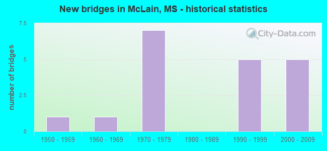
- New bridges - historical statistics
- 11950-1959
- 11960-1969
- 71970-1979
- 51990-1999
- 52000-2009


- Bridge Condition - Deck
- 9.1%Very good
- 90.9%Good

- Bridge Condition - Superstructure
- 45.5%Very good
- 45.5%Good
- 9.1%Satisfactory

- Bridge Condition - Substructure
- 36.4%Very good
- 45.5%Good
- 18.2%Fair

- Bridge Condition - Channel
- 10.5%Very good
- 26.3%Good
- 57.9%Satisfactory
- 5.3%Fair

- Bridge Condition - Culverts
- 75.0%Good
- 25.0%Satisfactory
Find on map >> Show street view
Structure Number: 21000980211894A, Location: 2.0 MI E PERRY CL (Lat: 31.107489, Lng: -88.805161), Route carried "on" structure: US 98, Year Built: 1991, Status: Open, Structure Length: 66.51m (218.21ft), Average Daily Traffic: 4,350 (year 2020), Truck Traffic: 33%, Average Future Daily Traffic: 4,600 (year 2040), Design Load: HS 20, Features Intersected: LEAF RIVER
Minimum Vertical Clearance: 30+ m (98+ ft), Kilometerpoint: 18.514, Lanes on structure: 2, Base Highway Network: Yes (Inventory Route: 9, Subroute: 1), Owner: State Highway Agency, Approaching Roadway Width: 13.4m (44.0ft), Material/Design: Steel continuous, Design/Construction: Stringer/Multi-beam, Number Of Spans In Main Unit: 6, Number Of Approach Spans: 20, Length of Maximum Span: 76.2m (250.0ft), Curb-To-Curb Width: 12.2m (40.0ft), Out-to-Out Width: 13.0m (42.7ft)
Condition: Deck: Good, Superstructure: Very good, Substructure: Good, Channel: Fair, Operating Rating: 57.2 metric tons, Method Used To Determine Operating Rating: Load Factor (LF), Inventory Rating: 34.3 metric tons, Method Used To Determine Inventory Rating: Load Factor (LF), Structural Evaluation: Better than present minimum criteria, Deck Geometry: Better than present minimum criteria, Waterway Adequacy: Equal to present desirable criteria, Approach Roadway Alignment: Equal to present desirable criteria, Designated Inspection Frequency: Every 24 months, Underwater Inspection Frequency: Every 60 months, Inspection Date: June 2021, Underwater Inspection Date: June 2019, Deck Structure Type: Concrete Cast-file-Place
Find on map >> Show street view
Structure Number: 21000980211894B, Location: 2.0 MI E PERRY CL (Lat: 31.108475, Lng: -88.812064), Route carried "on" structure: US 98, Year Built: 1991, Status: Open, Structure Length: 67.70m (222.11ft), Average Daily Traffic: 4,350 (year 2020), Truck Traffic: 33%, Average Future Daily Traffic: 4,600 (year 2040), Design Load: HS 20, Features Intersected: LEAF RIVER
Minimum Vertical Clearance: 30+ m (98+ ft), Kilometerpoint: 3.121, Lanes on structure: 2, Base Highway Network: Yes (Inventory Route: 9, Subroute: 1), Owner: State Highway Agency, Approaching Roadway Width: 13.4m (44.0ft), Material/Design: Steel continuous, Design/Construction: Stringer/Multi-beam, Number Of Spans In Main Unit: 6, Number Of Approach Spans: 20, Length of Maximum Span: 76.2m (250.0ft), Curb-To-Curb Width: 12.2m (40.0ft), Out-to-Out Width: 13.0m (42.7ft)
Condition: Deck: Good, Superstructure: Very good, Substructure: Good, Channel: Satisfactory, Operating Rating: 57.2 metric tons, Method Used To Determine Operating Rating: Load Factor (LF), Inventory Rating: 34.3 metric tons, Method Used To Determine Inventory Rating: Load Factor (LF), Structural Evaluation: Better than present minimum criteria, Deck Geometry: Better than present minimum criteria, Waterway Adequacy: Equal to present desirable criteria, Approach Roadway Alignment: Equal to present desirable criteria, Designated Inspection Frequency: Every 24 months, Underwater Inspection Frequency: Every 60 months, Inspection Date: June 2021, Underwater Inspection Date: June 2019, Deck Structure Type: Concrete Cast-file-Place
Find on map >> Show street view
Structure Number: 21000980211933A, Location: 6.0 MI E PERRY CL (Lat: 31.083953, Lng: -88.756192), Route carried "on" structure: US 98, Year Built: 1994, Status: Open, Structure Length: 6.77m (22.21ft), Average Daily Traffic: 3,600 (year 2020), Truck Traffic: 34%, Average Future Daily Traffic: 3,800 (year 2040), Design Load: HS 20, Features Intersected: BIG OKTIBEE CREEK
Minimum Vertical Clearance: 30+ m (98+ ft), Kilometerpoint: 12.733, Lanes on structure: 2, Base Highway Network: Yes (Inventory Route: 9, Subroute: 1), Owner: State Highway Agency, Approaching Roadway Width: 13.4m (44.0ft), Material/Design: Prestressed concrete, Design/Construction: Stringer/Multi-beam, Number Of Spans In Main Unit: 1, Number Of Approach Spans: 4, Length of Maximum Span: 18.3m (60.0ft), Curb-To-Curb Width: 12.2m (40.0ft), Out-to-Out Width: 13.0m (42.7ft)
Condition: Deck: Good, Superstructure: Very good, Substructure: Very good, Channel: Good, Operating Rating: 57.8 metric tons, Method Used To Determine Operating Rating: Load Factor (LF), Inventory Rating: 34.6 metric tons, Method Used To Determine Inventory Rating: Load Factor (LF), Structural Evaluation: Equal to present desirable criteria, Deck Geometry: Better than present minimum criteria, Waterway Adequacy: Equal to present desirable criteria, Approach Roadway Alignment: Equal to present desirable criteria, Designated Inspection Frequency: Every 24 months, Inspection Date: April 2020, Deck Structure Type: Concrete Cast-file-Place
Find on map >> Show street view
Structure Number: 21000980211933B, Location: 6.0 MI E PERRY CL (Lat: 31.084214, Lng: -88.756939), Route carried "on" structure: US 98, Year Built: 1992, Status: Open, Structure Length: 6.77m (22.21ft), Average Daily Traffic: 3,600 (year 2020), Truck Traffic: 34%, Average Future Daily Traffic: 3,800 (year 2040), Design Load: HS 20, Features Intersected: BIG OKTIBEE CREEK
Minimum Vertical Clearance: 30+ m (98+ ft), Kilometerpoint: 9.479, Lanes on structure: 2, Base Highway Network: Yes (Inventory Route: 9, Subroute: 1), Owner: State Highway Agency, Approaching Roadway Width: 12.8m (42.0ft), Material/Design: Prestressed concrete, Design/Construction: Stringer/Multi-beam, Number Of Spans In Main Unit: 1, Number Of Approach Spans: 4, Length of Maximum Span: 18.3m (60.0ft), Curb-To-Curb Width: 12.2m (40.0ft), Out-to-Out Width: 13.0m (42.7ft)
Condition: Deck: Very good, Superstructure: Very good, Substructure: Very good, Channel: Good, Operating Rating: 57.8 metric tons, Method Used To Determine Operating Rating: Load Factor (LF), Inventory Rating: 34.6 metric tons, Method Used To Determine Inventory Rating: Load Factor (LF), Structural Evaluation: Equal to present desirable criteria, Deck Geometry: Better than present minimum criteria, Waterway Adequacy: Equal to present desirable criteria, Approach Roadway Alignment: Equal to present desirable criteria, Designated Inspection Frequency: Every 24 months, Inspection Date: April 2020, Deck Structure Type: Concrete Cast-file-Place
Find on map >> Show street view
Structure Number: 21000980561859, Location: 1.0 MI W GREENE CL (Lat: 31.129864, Lng: -88.853286), Route carried "on" structure: US 98, Year Built: 1968, Status: Open, Structure Length: 1.49m (4.89ft), Average Daily Traffic: 11,000 (year 2020), Truck Traffic: 27%, Average Future Daily Traffic: 12,000 (year 2040), Design Load: HS 20+Mod, Features Intersected: LITTLE CREEK
Minimum Vertical Clearance: 30+ m (98+ ft), Kilometerpoint: 30.524, Lanes on structure: 4, Base Highway Network: Yes (Inventory Route: 9, Subroute: 1), Owner: State Highway Agency, Approaching Roadway Width: 9.8m (32.2ft), Material/Design: Concrete, Design/Construction: Culvert, Number Of Spans In Main Unit: 3, Length of Maximum Span: 4.6m (15.1ft)
Condition: Channel: Good, Culverts: Good, Inventory Rating: 85.5 metric tons, Method Used To Determine Inventory Rating: Load Factor (LF), Structural Evaluation: Better than present minimum criteria, Waterway Adequacy: Equal to present desirable criteria, Approach Roadway Alignment: Equal to present desirable criteria, Designated Inspection Frequency: Every 24 months, Inspection Date: June 2020
Find on map >> Show street view
Structure Number: 31000570210528, Location: 6.0 MI N GEORGE CL (Lat: 31.083133, Lng: -88.814322), Route carried "on" structure: State highway 57, Year Built: 1956, Status: Open, Structure Length: 1.95m (6.40ft), Average Daily Traffic: 1,000 (year 2020), Truck Traffic: 14%, Average Future Daily Traffic: 1,000 (year 2040), Design Load: HS 15, Features Intersected: MILL CREEK
Minimum Vertical Clearance: 30+ m (98+ ft), Kilometerpoint: 10.174, Lanes on structure: 2, Base Highway Network: Yes (Inventory Route: 5, Subroute: 1), Owner: State Highway Agency, Approaching Roadway Width: 9.8m (32.2ft), Material/Design: Concrete, Design/Construction: Culvert, Number Of Spans In Main Unit: 3, Length of Maximum Span: 6.1m (20.0ft)
Condition: Channel: Satisfactory, Culverts: Good, Operating Rating: 38.6 metric tons, Method Used To Determine Operating Rating: Load Factor (LF), Inventory Rating: 23.0 metric tons, Method Used To Determine Inventory Rating: Load Factor (LF), Structural Evaluation: Equal to present minimum criteria, Waterway Adequacy: Equal to present desirable criteria, Approach Roadway Alignment: Equal to present desirable criteria, Designated Inspection Frequency: Every 24 months, Inspection Date: March 2020
Find on map >> Show street view
Structure Number: SA2100000000018, Location: SEC 5 T 1N R 8W (Lat: 31.083503, Lng: -88.810308), Route carried "on" structure: County highway 176, Year Built: 1997, Status: Open, Structure Length: 3.76m (12.34ft), Average Daily Traffic: 200 (year 2020), Truck Traffic: 5%, Average Future Daily Traffic: 250 (year 2040), Design Load: HS 20, Features Intersected: MILL CREEK, Facility Carried by Structure: MOODY CHAPEL ROAD
Minimum Vertical Clearance: 30+ m (98+ ft), Kilometerpoint: 1.609, Lanes on structure: 2, Owner: County Highway Agency, Approaching Roadway Width: 6.1m (20.0ft), Material/Design: Concrete, Design/Construction: Channel Beam, Number Of Spans In Main Unit: 4, Length of Maximum Span: 9.5m (31.2ft), Curb or Sidewalk Widths: Left: 0.2m (0.7ft), Right: 0.2m (0.7ft), Curb-To-Curb Width: 8.1m (26.6ft), Out-to-Out Width: 8.8m (28.9ft)
Condition: Deck: Good, Superstructure: Good, Substructure: Good, Channel: Good, Operating Rating: 75.8 metric tons, Method Used To Determine Operating Rating: Load Factor (LF), Inventory Rating: 45.4 metric tons, Method Used To Determine Inventory Rating: Load Factor (LF), Structural Evaluation: Better than present minimum criteria, Deck Geometry: Somewhat better than minimum adequacy, Waterway Adequacy: Superior to present desirable criteria, Approach Roadway Alignment: Equal to present desirable criteria, Designated Inspection Frequency: Every 24 months, Inspection Date: October 2020, Deck Structure Type: Concrete Precast Panels
Find on map >> Show street view
Structure Number: SA210000000002, Location: SEC 21 T 1N R 8W (Lat: 31.037814, Lng: -88.793767), Route carried "on" structure: County highway 178, Year Built: 2001, Status: Open, Structure Length: 2.32m (7.61ft), Average Daily Traffic: 50 (year 2020), Truck Traffic: 2%, Average Future Daily Traffic: 75 (year 2040), Design Load: HS 20, Features Intersected: MCMILLAN CREEK, Facility Carried by Structure: JERICHO LOOP
Minimum Vertical Clearance: 30+ m (98+ ft), Kilometerpoint: 4.667, Lanes on structure: 2, Owner: County Highway Agency, Approaching Roadway Width: 7.4m (24.3ft), Material/Design: Concrete, Design/Construction: Channel Beam, Number Of Spans In Main Unit: 4, Length of Maximum Span: 5.8m (19.0ft), Curb or Sidewalk Widths: Left: 0.2m (0.7ft), Right: 0.2m (0.7ft), Curb-To-Curb Width: 7.4m (24.3ft), Out-to-Out Width: 7.9m (25.9ft)
Condition: Deck: Good, Superstructure: Very good, Substructure: Good, Channel: Satisfactory, Operating Rating: 70.6 metric tons, Method Used To Determine Operating Rating: Load Factor (LF), Inventory Rating: 42.2 metric tons, Method Used To Determine Inventory Rating: Load Factor (LF), Structural Evaluation: Better than present minimum criteria, Deck Geometry: Equal to present minimum criteria, Waterway Adequacy: Superior to present desirable criteria, Approach Roadway Alignment: Equal to present desirable criteria, Designated Inspection Frequency: Every 24 months, Inspection Date: October 2020, Deck Structure Type: Concrete Precast Panels
Find on map >> Show street view
Structure Number: SA2100000000043, Location: SEC 8 T 2N R 8W B (Lat: 31.147033, Lng: -88.820114), Route carried "on" structure: County highway 165, Year Built: 1979, Status: Open, Structure Length: 0.67m (2.20ft), Average Daily Traffic: 50 (year 2020), Truck Traffic: 5%, Average Future Daily Traffic: 75 (year 2040), Design Load: HS 20, Features Intersected: MCSWAIN BRANCH, Facility Carried by Structure: LOOP RD
Minimum Vertical Clearance: 30+ m (98+ ft), Kilometerpoint: 5.310, Lanes on structure: 2, Owner: County Highway Agency, Approaching Roadway Width: 8.5m (27.9ft), Material/Design: Concrete, Design/Construction: Culvert, Number Of Spans In Main Unit: 2, Length of Maximum Span: 3.4m (11.2ft)
Condition: Channel: Satisfactory, Culverts: Good, Operating Rating: 60.8 metric tons, Method Used To Determine Operating Rating: Load Factor (LF), Inventory Rating: 36.6 metric tons, Method Used To Determine Inventory Rating: Load Factor (LF), Structural Evaluation: Better than present minimum criteria, Waterway Adequacy: Equal to present desirable criteria, Approach Roadway Alignment: Equal to present desirable criteria, Designated Inspection Frequency: Every 24 months, Inspection Date: December 2020
Find on map >> Show street view
Structure Number: SA2100000000044, Location: SEC 16 T 2N R 8W B (Lat: 31.140439, Lng: -88.799514), Route carried "on" structure: County highway 197, Year Built: 1970, Status: Posted for load, Structure Length: 4.88m (16.01ft), Average Daily Traffic: 400 (year 2021), Truck Traffic: 15%, Average Future Daily Traffic: 475 (year 2041), Design Load: HS 15, Features Intersected: ATKINSON CREEK, Facility Carried by Structure: OLD HWY 24
Minimum Vertical Clearance: 30+ m (98+ ft), Kilometerpoint: 5.149, Lanes on structure: 2, Owner: County Highway Agency, Approaching Roadway Width: 9.2m (30.2ft), Material/Design: Prestressed concrete, Design/Construction: Stringer/Multi-beam, Number Of Spans In Main Unit: 4, Length of Maximum Span: 12.2m (40.0ft), Curb or Sidewalk Widths: Left: 0.4m (1.3ft), Right: 0.4m (1.3ft), Curb-To-Curb Width: 7.9m (25.9ft), Out-to-Out Width: 8.8m (28.9ft)
Condition: Deck: Good, Superstructure: Good, Substructure: Fair, Channel: Satisfactory, Operating Rating: 12.1 metric tons, Method Used To Determine Operating Rating: Allowable Stress (AS), Inventory Rating: 3.9 metric tons, Method Used To Determine Inventory Rating: Allowable Stress (AS), Structural Evaluation: High priority of corrective action, Deck Geometry: Somewhat better than minimum adequacy, Waterway Adequacy: Superior to present desirable criteria, Approach Roadway Alignment: Equal to present desirable criteria, Bridge Posting: Required (Relationship of Operating Rating to Maximum Legal Load: > 39.9% below), Length Of Structure Improvement: 4.88m (16.01ft), Designated Inspection Frequency: Every 24 months, Inspection Date: January 2021, Bridge Improvement Cost: $115,000, Total Project Cost: $115,000 ( Estimate for 2019), Deck Structure Type: Concrete Cast-file-Place
Find on map >> Show street view
Structure Number: SA2100000000046, Location: SEC 30 T 2N R 8W B (Lat: 31.101814, Lng: -88.828606), Route carried "on" structure: County highway 171, Year Built: 1973, Status: Open, Structure Length: 0.79m (2.59ft), Average Daily Traffic: 400 (year 2020), Truck Traffic: 20%, Average Future Daily Traffic: 450 (year 2040), Design Load: HS 20, Features Intersected: UNNAMED CREEK, Facility Carried by Structure: THOMPSON HILL RD
Minimum Vertical Clearance: 30+ m (98+ ft), Kilometerpoint: 0.804, Lanes on structure: 2, Owner: County Highway Agency, Approaching Roadway Width: 9.1m (29.9ft), Material/Design: Concrete, Design/Construction: Culvert, Number Of Spans In Main Unit: 2, Length of Maximum Span: 4.0m (13.1ft)
Condition: Channel: Satisfactory, Culverts: Good, Operating Rating: 54.6 metric tons, Method Used To Determine Operating Rating: Load Factor (LF), Inventory Rating: 32.7 metric tons, Method Used To Determine Inventory Rating: Load Factor (LF), Structural Evaluation: Better than present minimum criteria, Waterway Adequacy: Equal to present desirable criteria, Approach Roadway Alignment: Equal to present desirable criteria, Designated Inspection Frequency: Every 24 months, Inspection Date: December 2020
Find on map >> Show street view
Structure Number: SA2100000000047, Location: SEC 30 T 2N R 8W B (Lat: 31.110450, Lng: -88.824906), Route carried "on" structure: County highway 197, Year Built: 1973, Status: Open, Structure Length: 2.90m (9.51ft), Average Daily Traffic: 520 (year 2021), Truck Traffic: 20%, Average Future Daily Traffic: 780 (year 2041), Design Load: H 15, Features Intersected: MCSWAIN BRANCH, Facility Carried by Structure: CHURCH AVE
Minimum Vertical Clearance: 30+ m (98+ ft), Kilometerpoint: 0.321, Lanes on structure: 2, Owner: County Highway Agency, Approaching Roadway Width: 6.4m (21.0ft), Material/Design: Concrete, Design/Construction: Channel Beam, Number Of Spans In Main Unit: 5, Length of Maximum Span: 5.8m (19.0ft), Curb or Sidewalk Widths: Left: 0.2m (0.7ft), Right: 0.2m (0.7ft), Curb-To-Curb Width: 8.1m (26.6ft), Out-to-Out Width: 8.6m (28.2ft)
Condition: Deck: Good, Superstructure: Satisfactory, Substructure: Fair, Channel: Satisfactory, Operating Rating: 46.1 metric tons, Method Used To Determine Operating Rating: Load Factor (LF), Inventory Rating: 27.6 metric tons, Method Used To Determine Inventory Rating: Load Factor (LF), Structural Evaluation: Somewhat better than minimum adequacy, Deck Geometry: Somewhat better than minimum adequacy, Waterway Adequacy: Equal to present minimum criteria, Approach Roadway Alignment: Equal to present desirable criteria, Length Of Structure Improvement: 8.99m (29.49ft), Designated Inspection Frequency: Every 24 months, Inspection Date: October 2020, Bridge Improvement Cost: $175,000, Roadway Improvement Cost: $130,000, Total Project Cost: $305,000 ( Estimate for 2016), Deck Structure Type: Concrete Precast Panels, Wearing Surface/Protective System: Wearing Surface: Bituminous
Find on map >> Show street view
Structure Number: SA2100000000048, Location: SEC 31 T 2N R 8W B (Lat: 31.095236, Lng: -88.839283), Route carried "on" structure: County highway 171, Year Built: 1973, Status: Open, Structure Length: 0.91m (2.99ft), Average Daily Traffic: 400 (year 2020), Truck Traffic: 20%, Average Future Daily Traffic: 450 (year 2040), Design Load: HS 20, Features Intersected: MCSWAIN BRANCH, Facility Carried by Structure: THOMPSON HILL RD
Minimum Vertical Clearance: 30+ m (98+ ft), Kilometerpoint: 2.092, Lanes on structure: 2, Owner: County Highway Agency, Approaching Roadway Width: 9.8m (32.2ft), Material/Design: Concrete, Design/Construction: Culvert, Number Of Spans In Main Unit: 2, Length of Maximum Span: 4.6m (15.1ft)
Condition: Channel: Satisfactory, Culverts: Good, Operating Rating: 54.6 metric tons, Method Used To Determine Operating Rating: Load Factor (LF), Inventory Rating: 32.7 metric tons, Method Used To Determine Inventory Rating: Load Factor (LF), Structural Evaluation: Better than present minimum criteria, Waterway Adequacy: Equal to present desirable criteria, Approach Roadway Alignment: Equal to present desirable criteria, Designated Inspection Frequency: Every 24 months, Inspection Date: December 2020
Find on map >> Show street view
Structure Number: SA2100000000109, Location: SEC 20 T 2N R 8W B (Lat: 31.115617, Lng: -88.819550), Route carried "on" structure: County highway 197, Year Built: 2005, Status: Open, Structure Length: 10.39m (34.09ft), Average Daily Traffic: 450 (year 2021), Truck Traffic: 10%, Average Future Daily Traffic: 675 (year 2041), Design Load: HS 20, Features Intersected: RELIEF TO LEAF RIVER, Facility Carried by Structure: OLD HWY 24
Minimum Vertical Clearance: 30+ m (98+ ft), Kilometerpoint: 0.152, Lanes on structure: 2, Owner: County Highway Agency, Approaching Roadway Width: 10.4m (34.1ft), Material/Design: Prestressed concrete, Design/Construction: Stringer/Multi-beam, Number Of Spans In Main Unit: 11, Length of Maximum Span: 9.4m (30.8ft), Curb or Sidewalk Widths: Left: 0.4m (1.3ft), Right: 0.4m (1.3ft), Curb-To-Curb Width: 9.1m (29.9ft), Out-to-Out Width: 9.9m (32.5ft)
Condition: Deck: Good, Superstructure: Good, Substructure: Very good, Channel: Very good, Operating Rating: 84.0 metric tons, Method Used To Determine Operating Rating: Load Factor (LF), Inventory Rating: 35.3 metric tons, Method Used To Determine Inventory Rating: Load Factor (LF), Structural Evaluation: Better than present minimum criteria, Deck Geometry: Equal to present minimum criteria, Waterway Adequacy: Superior to present desirable criteria, Approach Roadway Alignment: Equal to present desirable criteria, Designated Inspection Frequency: Every 24 months, Inspection Date: October 2021, Deck Structure Type: Concrete Cast-file-Place
Find on map >> Show street view
Structure Number: SA210000000011, Location: SEC 20 T 2N R 8W B (Lat: 31.120072, Lng: -88.817192), Route carried "on" structure: County highway 197, Year Built: 2005, Status: Open, Structure Length: 12.28m (40.29ft), Average Daily Traffic: 450 (year 2021), Truck Traffic: 10%, Average Future Daily Traffic: 675 (year 2041), Design Load: HS 20, Features Intersected: RELIEF TO LEAF RIVER, Facility Carried by Structure: OLD HWY 24
Minimum Vertical Clearance: 30+ m (98+ ft), Kilometerpoint: 0.670, Lanes on structure: 2, Owner: County Highway Agency, Approaching Roadway Width: 10.4m (34.1ft), Material/Design: Prestressed concrete, Design/Construction: Stringer/Multi-beam, Number Of Spans In Main Unit: 13, Length of Maximum Span: 9.4m (30.8ft), Curb or Sidewalk Widths: Left: 0.4m (1.3ft), Right: 0.4m (1.3ft), Curb-To-Curb Width: 9.1m (29.9ft), Out-to-Out Width: 9.9m (32.5ft)
Condition: Deck: Good, Superstructure: Good, Substructure: Very good, Channel: Very good, Operating Rating: 84.0 metric tons, Method Used To Determine Operating Rating: Load Factor (LF), Inventory Rating: 35.3 metric tons, Method Used To Determine Inventory Rating: Load Factor (LF), Structural Evaluation: Better than present minimum criteria, Deck Geometry: Equal to present minimum criteria, Waterway Adequacy: Superior to present desirable criteria, Approach Roadway Alignment: Equal to present desirable criteria, Designated Inspection Frequency: Every 24 months, Inspection Date: October 2021, Deck Structure Type: Concrete Cast-file-Place
Find on map >> Show street view
Structure Number: SA2100000000111, Location: SEC 20 T 2N R 8W B (Lat: 31.127269, Lng: -88.815042), Route carried "on" structure: Alternate County highway 197, Year Built: 2005, Status: Open, Structure Length: 69.19m (227.00ft), Average Daily Traffic: 663 (year 2021), Truck Traffic: 10%, Average Future Daily Traffic: 728 (year 2041), Design Load: HS 20, Features Intersected: LEAF RIVER, Facility Carried by Structure: OLD HWY 24
Minimum Vertical Clearance: 30+ m (98+ ft), Kilometerpoint: 1.019, Lanes on structure: 2, Owner: County Highway Agency, Approaching Roadway Width: 9.5m (31.2ft), Material/Design: Steel continuous, Design/Construction: Stringer/Multi-beam, Number Of Spans In Main Unit: 3, Number Of Approach Spans: 42, Length of Maximum Span: 73.2m (240.2ft), Curb-To-Curb Width: 9.1m (29.9ft), Out-to-Out Width: 10.0m (32.8ft)
Condition: Deck: Good, Superstructure: Good, Substructure: Good, Channel: Good, Operating Rating: 56.0 metric tons, Method Used To Determine Operating Rating: Load Factor (LF), Inventory Rating: 31.8 metric tons, Method Used To Determine Inventory Rating: Load Factor (LF), Structural Evaluation: Better than present minimum criteria, Deck Geometry: Equal to present minimum criteria, Waterway Adequacy: Superior to present desirable criteria, Approach Roadway Alignment: Better than present minimum criteria, Designated Inspection Frequency: Every 24 months, Inspection Date: November 2021, Deck Structure Type: Concrete Cast-file-Place
Find on map >> Show street view
Structure Number: SA5600000000004, Location: SEC 1 T 1N R 9W B (Lat: 31.079792, Lng: -88.851525), Route carried "on" structure: County highway 9, Year Built: 2002, Status: Open, Structure Length: 0.98m (3.22ft), Average Daily Traffic: 200 (year 2021), Truck Traffic: 8%, Average Future Daily Traffic: 300 (year 2043), Design Load: HS 20, Features Intersected: HARVERSON MILL CREEK, Facility Carried by Structure: PROGRESS ROAD
Minimum Vertical Clearance: 30+ m (98+ ft), Kilometerpoint: 7.402, Lanes on structure: 2, Owner: County Highway Agency, Approaching Roadway Width: 9.1m (29.9ft), Skew: 1 degrees, Material/Design: Concrete, Design/Construction: Culvert, Number Of Spans In Main Unit: 2, Length of Maximum Span: 4.9m (16.1ft)
Condition: Channel: Satisfactory, Culverts: Good, Operating Rating: 71.2 metric tons, Method Used To Determine Operating Rating: Load Factor (LF), Inventory Rating: 36.9 metric tons, Method Used To Determine Inventory Rating: Load Factor (LF), Structural Evaluation: Better than present minimum criteria, Waterway Adequacy: Equal to present desirable criteria, Approach Roadway Alignment: Equal to present desirable criteria, Designated Inspection Frequency: Every 24 months, Inspection Date: April 2021
Find on map >> Show street view
Structure Number: SA5600000000039, Location: SEC 23 T 2N R 9W B (Lat: 31.118228, Lng: -88.870194), Route carried "on" structure: County highway 10, Year Built: 1976, Status: Open, Structure Length: 0.88m (2.89ft), Average Daily Traffic: 320 (year 2021), Truck Traffic: 5%, Average Future Daily Traffic: 480 (year 2043), Design Load: HS 20, Features Intersected: LITTLE CREEK, Facility Carried by Structure: LITTLE CREEK ROAD
Minimum Vertical Clearance: 30+ m (98+ ft), Kilometerpoint: 5.149, Lanes on structure: 2, Owner: County Highway Agency, Approaching Roadway Width: 9.1m (29.9ft), Material/Design: Concrete, Design/Construction: Culvert, Number Of Spans In Main Unit: 2, Length of Maximum Span: 4.3m (14.1ft)
Condition: Channel: Satisfactory, Culverts: Satisfactory, Operating Rating: 54.6 metric tons, Method Used To Determine Operating Rating: Load Factor (LF), Inventory Rating: 32.7 metric tons, Method Used To Determine Inventory Rating: Load Factor (LF), Structural Evaluation: Equal to present minimum criteria, Waterway Adequacy: Better than present minimum criteria, Approach Roadway Alignment: Equal to present desirable criteria, Designated Inspection Frequency: Every 24 months, Inspection Date: April 2021
Find on map >> Show street view
Structure Number: SA560000000004, Location: SEC 26 T 2N R 9W B (Lat: 31.110114, Lng: -88.871369), Route carried "on" structure: County highway 10, Year Built: 1976, Status: Open, Structure Length: 1.13m (3.71ft), Average Daily Traffic: 300 (year 2021), Truck Traffic: 5%, Average Future Daily Traffic: 450 (year 2043), Design Load: HS 20, Features Intersected: WELDY CREEK, Facility Carried by Structure: LITTLE CREEK ROAD
Minimum Vertical Clearance: 30+ m (98+ ft), Kilometerpoint: 4.023, Lanes on structure: 2, Owner: County Highway Agency, Approaching Roadway Width: 9.1m (29.9ft), Material/Design: Concrete, Design/Construction: Culvert, Number Of Spans In Main Unit: 2, Length of Maximum Span: 5.5m (18.0ft)
Condition: Channel: Satisfactory, Culverts: Satisfactory, Operating Rating: 59.2 metric tons, Method Used To Determine Operating Rating: Load Factor (LF), Inventory Rating: 35.3 metric tons, Method Used To Determine Inventory Rating: Load Factor (LF), Structural Evaluation: Equal to present minimum criteria, Waterway Adequacy: Better than present minimum criteria, Approach Roadway Alignment: Equal to present desirable criteria, Designated Inspection Frequency: Every 24 months, Inspection Date: April 2021