Bridge Statistics for Mead, Washington (WA)
Condition, Traffic, Stress, Structural Evaluation, Project Costs
- National Bridge Inventory (NBI) Statistics
- 43Number of bridges
- 535ft / 163mTotal length
- $110,355,000Total costs
- 350,896Total average daily traffic
- 17,905Total average daily truck traffic
- National Bridge Inventory (NBI) Registered Bridges for Mead
- No street view available for this location
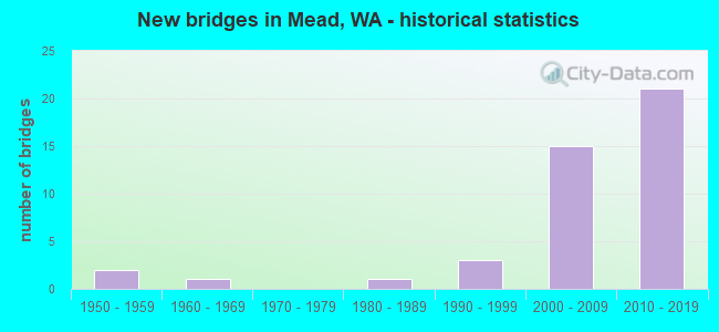
- New bridges - historical statistics
- 21950-1959
- 11960-1969
- 11980-1989
- 31990-1999
- 152000-2009
- 212010-2019
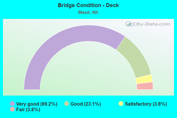
- Bridge Condition - Deck
- 69.2%Very good
- 23.1%Good
- 3.8%Satisfactory
- 3.8%Fair
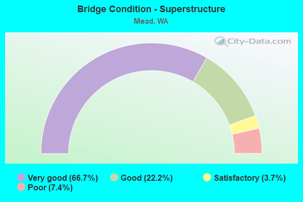
- Bridge Condition - Superstructure
- 66.7%Very good
- 22.2%Good
- 3.7%Satisfactory
- 7.4%Poor
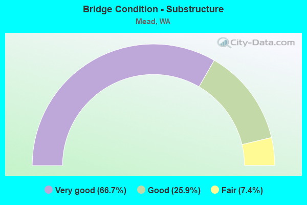
- Bridge Condition - Substructure
- 66.7%Very good
- 25.9%Good
- 7.4%Fair
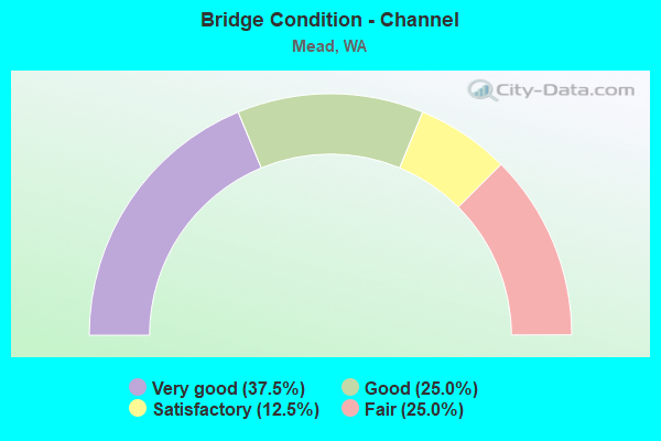
- Bridge Condition - Channel
- 37.5%Very good
- 25.0%Good
- 12.5%Satisfactory
- 25.0%Fair
Find on map >> Show street view
Structure Number: 16720A, Location: 8.9 N JCT I-90 (Lat: 47.772697, Lng: -117.370283), Route carried "on" structure: US 395, Year Built: 2006, Status: Open, Structure Length: 4.15m (13.62ft), Average Daily Traffic: 3,717 (year 2019), Truck Traffic: 8%, Average Future Daily Traffic: 4,787 (year 2039), Design Load: HL 93, Features Intersected: FARWELL RD
Minimum Vertical Clearance: 30+ m (98+ ft), Kilometerpoint: 266.668, Lanes on structure: 2, Lanes under structure: 5, Base Highway Network: Yes, Owner: State Highway Agency, Approaching Roadway Width: 13.7m (44.9ft), Skew: 3 degrees, Material/Design: Prestressed concrete, Design/Construction: Box Beam or Girders - Multiple, Number Of Spans In Main Unit: 1, Length of Maximum Span: 40.5m (132.9ft), Curb-To-Curb Width: 13.9m (45.6ft), Out-to-Out Width: 15.4m (50.5ft)
Condition: Deck: Very good, Superstructure: Very good, Substructure: Very good, Operating Rating: 64.8 metric tons, Method Used To Determine Operating Rating: Load and Resistance Factor Rating (LRFR) rating reported by rating factor(RF) method using HL-93 loadings, Inventory Rating: 35.0 metric tons, Method Used To Determine Inventory Rating: Load and Resistance Factor Rating (LRFR) rating reported by rating factor(RF) method using HL-93 loadings, Structural Evaluation: Equal to present desirable criteria, Deck Geometry: Superior to present desirable criteria, Underclear: Superior to present desirable criteria, Approach Roadway Alignment: Equal to present desirable criteria, Length Of Structure Improvement: 4.15m (13.62ft), Designated Inspection Frequency: Every 24 months, Inspection Date: June 2021, Bridge Improvement Cost: $1,278,000, Roadway Improvement Cost: $256,000, Total Project Cost: $2,557,000 ( Estimate for 2014), Deck Structure Type: Concrete Cast-file-Place, Wearing Surface/Protective System: Wearing Surface: Monolithic Concrete, Deck Protection: Epoxy Coated Reinforcing
Find on map >> Show street view
Structure Number: 16720B, Location: 8.9 N JCT I-90 (Lat: 47.772694, Lng: -117.370806), Route carried "on" structure: US 395, Year Built: 2006, Status: Open, Structure Length: 4.15m (13.62ft), Average Daily Traffic: 3,717 (year 2019), Truck Traffic: 8%, Average Future Daily Traffic: 4,787 (year 2039), Design Load: HL 93, Features Intersected: FARWELL RD
Minimum Vertical Clearance: 30+ m (98+ ft), Kilometerpoint: 266.684, Lanes on structure: 2, Lanes under structure: 5, Base Highway Network: Yes, Owner: State Highway Agency, Approaching Roadway Width: 11.6m (38.1ft), Skew: 3 degrees, Material/Design: Prestressed concrete, Design/Construction: Box Beam or Girders - Multiple, Number Of Spans In Main Unit: 1, Length of Maximum Span: 40.5m (132.9ft), Curb-To-Curb Width: 11.6m (38.1ft), Out-to-Out Width: 12.6m (41.3ft)
Condition: Deck: Very good, Superstructure: Very good, Substructure: Very good, Operating Rating: 65.1 metric tons, Method Used To Determine Operating Rating: Load and Resistance Factor Rating (LRFR) rating reported by rating factor(RF) method using HL-93 loadings, Inventory Rating: 28.2 metric tons, Method Used To Determine Inventory Rating: Load and Resistance Factor Rating (LRFR) rating reported by rating factor(RF) method using HL-93 loadings, Structural Evaluation: Better than present minimum criteria, Deck Geometry: Equal to present minimum criteria, Underclear: Superior to present desirable criteria, Approach Roadway Alignment: Equal to present desirable criteria, Length Of Structure Improvement: 4.15m (13.62ft), Designated Inspection Frequency: Every 24 months, Inspection Date: June 2021, Bridge Improvement Cost: $1,088,000, Roadway Improvement Cost: $218,000, Total Project Cost: $2,176,000 ( Estimate for 2014), Deck Structure Type: Concrete Cast-file-Place, Wearing Surface/Protective System: Wearing Surface: Monolithic Concrete, Deck Protection: Epoxy Coated Reinforcing
Find on map >> Show street view
Structure Number: 16720C, Location: 4.8 E JCT SR 291 (Lat: 47.773031, Lng: -117.371464), Route carried "on" structure: Ramp US 2, Year Built: 2004, Status: Open, Structure Length: 4.51m (14.80ft), Average Daily Traffic: 2,967 (year 2019), Truck Traffic: 5%, Average Future Daily Traffic: 3,821 (year 2039), Design Load: HL 93, Features Intersected: FARWELL RD
Minimum Vertical Clearance: 30+ m (98+ ft), Kilometerpoint: 1.658, Lanes on structure: 1, Lanes under structure: 5, Owner: State Highway Agency, Approaching Roadway Width: 11.3m (37.1ft), Skew: 3 degrees, Material/Design: Prestressed concrete, Design/Construction: Box Beam or Girders - Single/Spread, Number Of Spans In Main Unit: 1, Length of Maximum Span: 44.5m (146.0ft), Curb-To-Curb Width: 11.3m (37.1ft), Out-to-Out Width: 12.3m (40.4ft)
Condition: Deck: Very good, Superstructure: Very good, Substructure: Very good, Operating Rating: 89.8 metric tons, Method Used To Determine Operating Rating: Load Factor (LF), Inventory Rating: 54.4 metric tons, Method Used To Determine Inventory Rating: Load Factor (LF), Structural Evaluation: Equal to present desirable criteria, Deck Geometry: Superior to present desirable criteria, Underclear: Superior to present desirable criteria, Approach Roadway Alignment: Equal to present desirable criteria, Length Of Structure Improvement: 4.51m (14.80ft), Designated Inspection Frequency: Every 24 months, Inspection Date: May 2021, Bridge Improvement Cost: $1,154,000, Roadway Improvement Cost: $231,000, Total Project Cost: $2,309,000 ( Estimate for 2014), Deck Structure Type: Concrete Cast-file-Place, Wearing Surface/Protective System: Wearing Surface: Monolithic Concrete, Deck Protection: Epoxy Coated Reinforcing
Find on map >> Show street view
Structure Number: 16720D, Location: 8.9 N JCT I-90 (Lat: 47.772683, Lng: -117.369953), Route carried "on" structure: Ramp US 395, Year Built: 2004, Status: Open, Structure Length: 4.15m (13.62ft), Average Daily Traffic: 2,609 (year 2019), Truck Traffic: 5%, Average Future Daily Traffic: 3,360 (year 2039), Design Load: HL 93, Features Intersected: FARWELL RD
Minimum Vertical Clearance: 30+ m (98+ ft), Kilometerpoint: 0.467, Lanes on structure: 2, Lanes under structure: 5, Owner: State Highway Agency, Approaching Roadway Width: 11.3m (37.1ft), Skew: 2 degrees, Material/Design: Prestressed concrete, Design/Construction: Box Beam or Girders - Multiple, Number Of Spans In Main Unit: 1, Length of Maximum Span: 40.5m (132.9ft), Curb-To-Curb Width: 11.3m (37.1ft), Out-to-Out Width: 12.3m (40.4ft)
Condition: Deck: Very good, Superstructure: Good, Substructure: Very good, Operating Rating: 89.8 metric tons, Method Used To Determine Operating Rating: Load Factor (LF), Inventory Rating: 44.4 metric tons, Method Used To Determine Inventory Rating: Load Factor (LF), Structural Evaluation: Better than present minimum criteria, Deck Geometry: Superior to present desirable criteria, Underclear: Superior to present desirable criteria, Approach Roadway Alignment: Equal to present desirable criteria, Length Of Structure Improvement: 4.15m (13.62ft), Designated Inspection Frequency: Every 24 months, Inspection Date: June 2021, Bridge Improvement Cost: $1,061,000, Roadway Improvement Cost: $212,000, Total Project Cost: $2,122,000 ( Estimate for 2014), Deck Structure Type: Concrete Cast-file-Place, Wearing Surface/Protective System: Wearing Surface: Monolithic Concrete, Deck Protection: Epoxy Coated Reinforcing
Find on map >> Show street view
Structure Number: 17177A, Location: 6.0 N JCT I-90 (Lat: 47.742667, Lng: -117.360194), Route carried "on" structure: Spur US 395, Year Built: 2009, Status: Open, Structure Length: 4.42m (14.50ft), Average Daily Traffic: 6,911 (year 2019), Truck Traffic: 8%, Average Future Daily Traffic: 8,901 (year 2039), Design Load: HL 93, Features Intersected: FAIRVIEW RD
Minimum Vertical Clearance: 30+ m (98+ ft), Kilometerpoint: 263.112, Lanes on structure: 3, Lanes under structure: 2, Base Highway Network: Yes, Owner: State Highway Agency, Approaching Roadway Width: 17.1m (56.1ft), Skew: 3 degrees, Material/Design: Prestressed concrete, Design/Construction: Stringer/Multi-beam, Number Of Spans In Main Unit: 1, Length of Maximum Span: 42.4m (139.1ft), Curb-To-Curb Width: 17.1m (56.1ft), Out-to-Out Width: 18.2m (59.7ft)
Condition: Deck: Very good, Superstructure: Very good, Substructure: Very good, Operating Rating: 89.8 metric tons, Method Used To Determine Operating Rating: Load Factor (LF), Inventory Rating: 66.2 metric tons, Method Used To Determine Inventory Rating: Load Factor (LF), Structural Evaluation: Equal to present desirable criteria, Deck Geometry: Equal to present minimum criteria, Underclear: Better than present minimum criteria, Approach Roadway Alignment: Equal to present desirable criteria, Length Of Structure Improvement: 4.42m (14.50ft), Designated Inspection Frequency: Every 24 months, Inspection Date: August 2021, Bridge Improvement Cost: $1,682,000, Roadway Improvement Cost: $336,000, Total Project Cost: $3,364,000 ( Estimate for 2014), Deck Structure Type: Concrete Cast-file-Place, Wearing Surface/Protective System: Wearing Surface: Monolithic Concrete, Deck Protection: Epoxy Coated Reinforcing
Find on map >> Show street view
Structure Number: 17177B, Location: 6.9 N JCT I-90 (Lat: 47.752500, Lng: -117.359556), Route carried "on" structure: Spur US 395, Year Built: 2007, Status: Open, Structure Length: 4.33m (14.21ft), Average Daily Traffic: 6,453 (year 2019), Truck Traffic: 8%, Average Future Daily Traffic: 8,311 (year 2039), Design Load: HL 93, Features Intersected: MARKET STREET
Minimum Vertical Clearance: 30+ m (98+ ft), Kilometerpoint: 264.222, Lanes on structure: 4, Lanes under structure: 2, Base Highway Network: Yes, Owner: State Highway Agency, Approaching Roadway Width: 17.1m (56.1ft), Skew: 4 degrees, Material/Design: Prestressed concrete, Design/Construction: Stringer/Multi-beam, Number Of Spans In Main Unit: 1, Length of Maximum Span: 42.7m (140.1ft), Curb or Sidewalk Widths: Left: 0.0m, Right: 4.9m (16.1ft), Curb-To-Curb Width: 24.1m (79.1ft), Out-to-Out Width: 30.8m (101.0ft)
Condition: Deck: Very good, Superstructure: Very good, Substructure: Very good, Operating Rating: 89.8 metric tons, Method Used To Determine Operating Rating: Load Factor (LF), Inventory Rating: 59.0 metric tons, Method Used To Determine Inventory Rating: Load Factor (LF), Structural Evaluation: Equal to present desirable criteria, Deck Geometry: Superior to present desirable criteria, Underclear: Superior to present desirable criteria, Approach Roadway Alignment: Equal to present desirable criteria, Length Of Structure Improvement: 4.33m (14.21ft), Designated Inspection Frequency: Every 24 months, Inspection Date: August 2021, Bridge Improvement Cost: $1,647,000, Roadway Improvement Cost: $329,000, Total Project Cost: $3,294,000 ( Estimate for 2014), Deck Structure Type: Concrete Cast-file-Place, Wearing Surface/Protective System: Wearing Surface: Monolithic Concrete, Deck Protection: Epoxy Coated Reinforcing
Find on map >> Show street view
Structure Number: 17177C, Location: 7.1 N JCT I-90 (Lat: 47.756667, Lng: -117.362500), Route carried "on" structure: Spur US 395, Year Built: 2009, Status: Open, Structure Length: 8.41m (27.59ft), Average Daily Traffic: 6,453 (year 2019), Truck Traffic: 8%, Average Future Daily Traffic: 8,311 (year 2039), Design Load: HL 93, Features Intersected: PARKSMITH DR & RR
Minimum Vertical Clearance: 30+ m (98+ ft), Kilometerpoint: 264.721, Lanes on structure: 4, Lanes under structure: 2, Base Highway Network: Yes, Owner: State Highway Agency, Approaching Roadway Width: 23.5m (77.1ft), Material/Design: Prestressed concrete continuous, Design/Construction: Stringer/Multi-beam, Number Of Spans In Main Unit: 2, Length of Maximum Span: 40.5m (132.9ft), Curb or Sidewalk Widths: Left: 0.0m, Right: 4.9m (16.1ft), Curb-To-Curb Width: 24.8m (81.4ft), Out-to-Out Width: 32.6m (107.0ft)
Condition: Deck: Very good, Superstructure: Very good, Substructure: Very good, Operating Rating: 68.0 metric tons, Method Used To Determine Operating Rating: Load Factor (LF), Inventory Rating: 40.8 metric tons, Method Used To Determine Inventory Rating: Load Factor (LF), Structural Evaluation: Equal to present desirable criteria, Deck Geometry: Superior to present desirable criteria, Underclear: Equal to present minimum criteria, Approach Roadway Alignment: Equal to present desirable criteria, Length Of Structure Improvement: 8.41m (27.59ft), Designated Inspection Frequency: Every 24 months, Inspection Date: August 2021, Bridge Improvement Cost: $4,361,000, Roadway Improvement Cost: $872,000, Total Project Cost: $8,722,000 ( Estimate for 2014), Deck Structure Type: Concrete Cast-file-Place, Wearing Surface/Protective System: Wearing Surface: Monolithic Concrete, Deck Protection: Epoxy Coated Reinforcing
Find on map >> Show street view
Structure Number: 17177D, Location: 9.5 N JCT I-90 (Lat: 47.774694, Lng: -117.373778), Route carried "on" structure: County highway 395, Year Built: 2008, Status: Open, Structure Length: 8.38m (27.49ft), Average Daily Traffic: 2,500 (year 2015), Truck Traffic: 4%, Average Future Daily Traffic: 3,325 (year 2037), Design Load: HL 93, Features Intersected: US 2, Facility Carried by Structure: SHADY SLOPE RD
Minimum Vertical Clearance: 30+ m (98+ ft), Kilometerpoint: 0.241, Lanes on structure: 2, Lanes under structure: 6, Owner: State Highway Agency, Approaching Roadway Width: 11.0m (36.1ft), Material/Design: Prestressed concrete, Design/Construction: Box Beam or Girders - Multiple, Number Of Spans In Main Unit: 2, Length of Maximum Span: 45.7m (149.9ft), Curb or Sidewalk Widths: Left: 1.8m (5.9ft), Right: 1.8m (5.9ft), Curb-To-Curb Width: 11.0m (36.1ft), Out-to-Out Width: 15.5m (50.9ft)
Condition: Deck: Very good, Superstructure: Very good, Substructure: Very good, Operating Rating: 62.6 metric tons, Method Used To Determine Operating Rating: Load Factor (LF), Inventory Rating: 37.2 metric tons, Method Used To Determine Inventory Rating: Load Factor (LF), Structural Evaluation: Equal to present desirable criteria, Deck Geometry: Somewhat better than minimum adequacy, Underclear: Better than present minimum criteria, Approach Roadway Alignment: Equal to present desirable criteria, Length Of Structure Improvement: 8.38m (27.49ft), Designated Inspection Frequency: Every 48 months, Inspection Date: August 2018, Bridge Improvement Cost: $2,090,000, Roadway Improvement Cost: $418,000, Total Project Cost: $4,180,000 ( Estimate for 2014), Deck Structure Type: Concrete Cast-file-Place, Wearing Surface/Protective System: Wearing Surface: Monolithic Concrete, Deck Protection: Epoxy Coated Reinforcing
Find on map >> Show street view
Structure Number: 17177E, Location: 7.8 N JCT I-90 (Lat: 47.775972, Lng: -117.374500), Route carried "on" structure: County highway , Year Built: 2008, Status: Open, Structure Length: 10.52m (34.51ft), Average Daily Traffic: 4,265 (year 2011), Truck Traffic: 5%, Design Load: HL 93, Features Intersected: US 395, Facility Carried by Structure: SHADY SLOPE ROAD
Minimum Vertical Clearance: 30+ m (98+ ft), Kilometerpoint: 0.386, Lanes on structure: 2, Lanes under structure: 5, Owner: State Highway Agency, Approaching Roadway Width: 11.0m (36.1ft), Skew: 2 degrees, Material/Design: Prestressed concrete continuous, Design/Construction: Box Beam or Girders - Multiple, Number Of Spans In Main Unit: 2, Length of Maximum Span: 54.9m (180.1ft), Curb or Sidewalk Widths: Left: 1.8m (5.9ft), Right: 1.8m (5.9ft), Curb-To-Curb Width: 11.0m (36.1ft), Out-to-Out Width: 15.5m (50.9ft)
Condition: Deck: Very good, Superstructure: Very good, Substructure: Very good, Operating Rating: 84.4 metric tons, Method Used To Determine Operating Rating: Load Factor (LF), Inventory Rating: 50.8 metric tons, Method Used To Determine Inventory Rating: Load Factor (LF), Structural Evaluation: Equal to present desirable criteria, Deck Geometry: Somewhat better than minimum adequacy, Underclear: Superior to present desirable criteria, Approach Roadway Alignment: Equal to present desirable criteria, Length Of Structure Improvement: 10.52m (34.51ft), Designated Inspection Frequency: Every 48 months, Inspection Date: August 2018, Bridge Improvement Cost: $2,622,000, Roadway Improvement Cost: $524,000, Total Project Cost: $5,244,000 ( Estimate for 2014), Deck Structure Type: Concrete Cast-file-Place, Wearing Surface/Protective System: Wearing Surface: Monolithic Concrete, Deck Protection: Epoxy Coated Reinforcing
Find on map >> Show street view
Structure Number: 17278B, Location: 6.0 N JCT I-90 (Lat: 47.735000, Lng: -117.358750), Route carried "on" structure: Spur US 395, Year Built: 2008, Status: Open, Structure Length: 3.32m (10.89ft), Average Daily Traffic: 6,911 (year 2019), Truck Traffic: 8%, Average Future Daily Traffic: 8,901 (year 2039), Design Load: HL 93, Features Intersected: GERLACH RD
Minimum Vertical Clearance: 30+ m (98+ ft), Kilometerpoint: 262.259, Lanes on structure: 3, Lanes under structure: 2, Base Highway Network: Yes, Owner: State Highway Agency, Approaching Roadway Width: 17.1m (56.1ft), Skew: 1 degrees, Material/Design: Prestressed concrete, Design/Construction: Stringer/Multi-beam, Number Of Spans In Main Unit: 1, Length of Maximum Span: 31.7m (104.0ft), Curb-To-Curb Width: 17.1m (56.1ft), Out-to-Out Width: 18.2m (59.7ft)
Condition: Deck: Very good, Superstructure: Very good, Substructure: Very good, Operating Rating: 67.1 metric tons, Method Used To Determine Operating Rating: Load Factor (LF), Inventory Rating: 39.9 metric tons, Method Used To Determine Inventory Rating: Load Factor (LF), Structural Evaluation: Equal to present desirable criteria, Deck Geometry: Equal to present minimum criteria, Underclear: Superior to present desirable criteria, Approach Roadway Alignment: Equal to present desirable criteria, Length Of Structure Improvement: 3.32m (10.89ft), Designated Inspection Frequency: Every 24 months, Inspection Date: August 2021, Bridge Improvement Cost: $1,264,000, Roadway Improvement Cost: $253,000, Total Project Cost: $2,529,000 ( Estimate for 2014), Deck Structure Type: Concrete Cast-file-Place, Wearing Surface/Protective System: Wearing Surface: Monolithic Concrete, Deck Protection: Epoxy Coated Reinforcing
Find on map >> Show street view
Structure Number: 17413A, Location: 6.7 N JCT I-90 (Lat: 47.749683, Lng: -117.359397), Route carried "on" structure: Spur US 395, Year Built: 2009, Status: Open, Structure Length: 6.80m (22.31ft), Average Daily Traffic: 13,821 (year 2019), Truck Traffic: 8%, Average Future Daily Traffic: 17,801 (year 2039), Design Load: HL 93, Features Intersected: BNSF RR
Minimum Vertical Clearance: 30+ m (98+ ft), Kilometerpoint: 263.916, Lanes on structure: 6, Base Highway Network: Yes, Owner: State Highway Agency, Approaching Roadway Width: 49.4m (162.1ft), Skew: 19 degrees, Material/Design: Concrete, Design/Construction: Arch - Deck, Number Of Spans In Main Unit: 1, Length of Maximum Span: 68.0m (223.1ft), Curb-To-Curb Width: 17.8m (58.4ft), Out-to-Out Width: 17.8m (58.4ft)
Condition: Superstructure: Very good, Substructure: Very good, Operating Rating: 89.8 metric tons, Method Used To Determine Operating Rating: Load Factor (LF), Inventory Rating: 89.8 metric tons, Method Used To Determine Inventory Rating: Load Factor (LF), Structural Evaluation: Equal to present desirable criteria, Deck Geometry: High priority of replacement, Underclear: Better than present minimum criteria, Approach Roadway Alignment: Equal to present desirable criteria, Length Of Structure Improvement: 6.80m (22.31ft), Designated Inspection Frequency: Every 24 months, Inspection Date: August 2021, Bridge Improvement Cost: $7,314,000, Roadway Improvement Cost: $1,463,000, Total Project Cost: $14,629,000 ( Estimate for 2014)
Find on map >> Show street view
Structure Number: 17610A, Location: 9.2 N JCT I-90 (Lat: 47.775306, Lng: -117.372750), Route carried "on" structure: US 395, Year Built: 2011, Status: Open, Structure Length: 7.32m (24.02ft), Average Daily Traffic: 3,717 (year 2019), Truck Traffic: 8%, Average Future Daily Traffic: 4,787 (year 2039), Design Load: HL 93, Features Intersected: US 2
Minimum Vertical Clearance: 5.54m (18.18ft), Kilometerpoint: 267.006, Lanes on structure: 2, Lanes under structure: 4, Base Highway Network: Yes, Owner: State Highway Agency, Approaching Roadway Width: 11.6m (38.1ft), Material/Design: Prestressed concrete continuous, Design/Construction: Stringer/Multi-beam, Number Of Spans In Main Unit: 2, Length of Maximum Span: 36.0m (118.1ft), Curb-To-Curb Width: 11.6m (38.1ft), Out-to-Out Width: 12.6m (41.3ft)
Condition: Deck: Good, Superstructure: Good, Substructure: Good, Operating Rating: 62.6 metric tons, Method Used To Determine Operating Rating: Load Factor (LF), Inventory Rating: 37.2 metric tons, Method Used To Determine Inventory Rating: Load Factor (LF), Structural Evaluation: Better than present minimum criteria, Deck Geometry: Equal to present minimum criteria, Underclear: Better than present minimum criteria, Approach Roadway Alignment: Equal to present desirable criteria, Length Of Structure Improvement: 7.32m (24.02ft), Designated Inspection Frequency: Every 24 months, Inspection Date: June 2021, Bridge Improvement Cost: $1,920,000, Roadway Improvement Cost: $384,000, Total Project Cost: $3,840,000 ( Estimate for 2014), Deck Structure Type: Concrete Cast-file-Place, Wearing Surface/Protective System: Wearing Surface: Monolithic Concrete, Deck Protection: Epoxy Coated Reinforcing
Find on map >> Show street view
Structure Number: 17610B, Location: 9.2 N JCT I-90 (Lat: 47.775167, Lng: -117.372972), Route carried "on" structure: US 395, Year Built: 2011, Status: Open, Structure Length: 7.32m (24.02ft), Average Daily Traffic: 3,717 (year 2019), Truck Traffic: 8%, Average Future Daily Traffic: 4,787 (year 2039), Design Load: HL 93, Features Intersected: US 2
Minimum Vertical Clearance: 30+ m (98+ ft), Kilometerpoint: 267.006, Lanes on structure: 2, Lanes under structure: 4, Base Highway Network: Yes, Owner: State Highway Agency, Approaching Roadway Width: 11.6m (38.1ft), Material/Design: Prestressed concrete continuous, Design/Construction: Stringer/Multi-beam, Number Of Spans In Main Unit: 2, Length of Maximum Span: 36.0m (118.1ft), Curb-To-Curb Width: 11.6m (38.1ft), Out-to-Out Width: 12.6m (41.3ft)
Condition: Deck: Good, Superstructure: Good, Substructure: Good, Operating Rating: 73.5 metric tons, Method Used To Determine Operating Rating: Load Factor (LF), Inventory Rating: 44.4 metric tons, Method Used To Determine Inventory Rating: Load Factor (LF), Structural Evaluation: Better than present minimum criteria, Deck Geometry: Equal to present minimum criteria, Underclear: Better than present minimum criteria, Approach Roadway Alignment: Equal to present desirable criteria, Length Of Structure Improvement: 7.32m (24.02ft), Designated Inspection Frequency: Every 24 months, Inspection Date: June 2021, Bridge Improvement Cost: $1,920,000, Roadway Improvement Cost: $384,000, Total Project Cost: $3,840,000 ( Estimate for 2014), Deck Structure Type: Concrete Cast-file-Place, Wearing Surface/Protective System: Wearing Surface: Monolithic Concrete, Deck Protection: Epoxy Coated Reinforcing
Find on map >> Show street view
Structure Number: 17610C, Location: JCT US 2 (Lat: 47.775472, Lng: -117.372333), Route carried "on" structure: Ramp US 395, Year Built: 2011, Status: Open, Structure Length: 7.01m (23.00ft), Average Daily Traffic: 1,508 (year 2019), Truck Traffic: 5%, Average Future Daily Traffic: 1,942 (year 2039), Design Load: HL 93, Features Intersected: US 2, Facility Carried by Structure: N-N RAMP
Minimum Vertical Clearance: 7.62m (25.00ft), Kilometerpoint: 0.354, Lanes on structure: 1, Lanes under structure: 4, Owner: State Highway Agency, Approaching Roadway Width: 7.9m (25.9ft), Skew: 31 degrees, Material/Design: Prestressed concrete continuous, Design/Construction: Stringer/Multi-beam, Number Of Spans In Main Unit: 2, Length of Maximum Span: 34.4m (112.9ft), Curb or Sidewalk Widths: Left: 0.0m, Right: 4.9m (16.1ft), Curb-To-Curb Width: 7.8m (25.6ft), Out-to-Out Width: 14.1m (46.3ft)
Condition: Deck: Good, Superstructure: Good, Substructure: Good, Operating Rating: 70.7 metric tons, Method Used To Determine Operating Rating: Load Factor (LF), Inventory Rating: 42.6 metric tons, Method Used To Determine Inventory Rating: Load Factor (LF), Structural Evaluation: Better than present minimum criteria, Deck Geometry: Better than present minimum criteria, Underclear: Better than present minimum criteria, Approach Roadway Alignment: Equal to present desirable criteria, Length Of Structure Improvement: 7.01m (23.00ft), Designated Inspection Frequency: Every 24 months, Inspection Date: June 2021, Bridge Improvement Cost: $1,288,000, Roadway Improvement Cost: $258,000, Total Project Cost: $2,576,000 ( Estimate for 2014), Deck Structure Type: Concrete Cast-file-Place, Wearing Surface/Protective System: Wearing Surface: Monolithic Concrete, Deck Protection: Epoxy Coated Reinforcing
Find on map >> Show street view
Structure Number: 17610D, Location: JCT US 395 (Lat: 47.774111, Lng: -117.372472), Route carried "on" structure: Ramp US 2, Year Built: 2011, Status: Open, Structure Length: 29.87m (98.00ft), Average Daily Traffic: 2,967 (year 2019), Truck Traffic: 5%, Average Future Daily Traffic: 3,821 (year 2039), Design Load: HL 93, Features Intersected: US 395/US 2/RAMP, Facility Carried by Structure: W-S RAMP
Minimum Vertical Clearance: 30+ m (98+ ft), Kilometerpoint: 1.239, Lanes on structure: 1, Lanes under structure: 9, Owner: State Highway Agency, Approaching Roadway Width: 11.6m (38.1ft), Material/Design: Steel continuous, Design/Construction: Stringer/Multi-beam, Number Of Spans In Main Unit: 6, Length of Maximum Span: 54.9m (180.1ft), Curb-To-Curb Width: 11.6m (38.1ft), Out-to-Out Width: 12.5m (41.0ft)
Condition: Deck: Very good, Superstructure: Very good, Substructure: Very good, Operating Rating: 46.7 metric tons, Method Used To Determine Operating Rating: Load and Resistance Factor Rating (LRFR) rating reported by rating factor(RF) method using HL-93 loadings, Inventory Rating: 36.0 metric tons, Method Used To Determine Inventory Rating: Load and Resistance Factor Rating (LRFR) rating reported by rating factor(RF) method using HL-93 loadings, Structural Evaluation: Equal to present desirable criteria, Deck Geometry: Superior to present desirable criteria, Underclear: Meets minimum limits, Approach Roadway Alignment: Equal to present desirable criteria, Length Of Structure Improvement: 29.87m (98.00ft), Designated Inspection Frequency: Every 24 months, Inspection Date: August 2021, Bridge Improvement Cost: $7,840,000, Roadway Improvement Cost: $1,568,000, Total Project Cost: $15,680,000 ( Estimate for 2014), Deck Structure Type: Concrete Cast-file-Place, Wearing Surface/Protective System: Wearing Surface: Monolithic Concrete, Deck Protection: Epoxy Coated Reinforcing
Find on map >> Show street view
Structure Number: 17610E, Location: JCT US 2 - NSC (Lat: 47.773986, Lng: -117.370406), Route carried "on" structure: Ramp US 395, Year Built: 2011, Status: Open, Structure Length: 6.71m (22.01ft), Average Daily Traffic: 2,609 (year 2019), Truck Traffic: 5%, Average Future Daily Traffic: 3,360 (year 2039), Design Load: HL 93, Features Intersected: N-E RAMP, Facility Carried by Structure: N-N RAMP
Minimum Vertical Clearance: 30+ m (98+ ft), Kilometerpoint: 0.628, Lanes on structure: 2, Lanes under structure: 1, Owner: State Highway Agency, Approaching Roadway Width: 11.3m (37.1ft), Material/Design: Prestressed concrete continuous, Design/Construction: Stringer/Multi-beam, Number Of Spans In Main Unit: 2, Length of Maximum Span: 32.0m (105.0ft), Curb-To-Curb Width: 11.3m (37.1ft), Out-to-Out Width: 12.3m (40.4ft)
Condition: Deck: Very good, Superstructure: Very good, Substructure: Very good, Operating Rating: 66.2 metric tons, Method Used To Determine Operating Rating: Load Factor (LF), Inventory Rating: 39.9 metric tons, Method Used To Determine Inventory Rating: Load Factor (LF), Structural Evaluation: Equal to present desirable criteria, Deck Geometry: Superior to present desirable criteria, Underclear: Superior to present desirable criteria, Approach Roadway Alignment: Equal to present desirable criteria, Length Of Structure Improvement: 6.71m (22.01ft), Designated Inspection Frequency: Every 24 months, Inspection Date: June 2021, Bridge Improvement Cost: $1,716,000, Roadway Improvement Cost: $343,000, Total Project Cost: $3,432,000 ( Estimate for 2014), Deck Structure Type: Concrete Cast-file-Place, Wearing Surface/Protective System: Wearing Surface: Monolithic Concrete, Deck Protection: Epoxy Coated Reinforcing
Find on map >> Show street view
Structure Number: 17610G, Location: 5.2 NE JCT SR 291 (Lat: 47.778575, Lng: -117.364769), Route carried "on" structure: US 2, Year Built: 2011, Status: Open, Structure Length: 0.94m (3.08ft), Average Daily Traffic: 25,797 (year 2019), Truck Traffic: 3%, Average Future Daily Traffic: 33,226 (year 2039), Design Load: HL 93, Features Intersected: DEADMAN CREEK
Minimum Vertical Clearance: 30+ m (98+ ft), Kilometerpoint: 476.993, Lanes on structure: 6, Base Highway Network: Yes, Owner: State Highway Agency, Approaching Roadway Width: 29.6m (97.1ft), Skew: 31 degrees, Material/Design: Steel, Design/Construction: Culvert, Number Of Spans In Main Unit: 1, Length of Maximum Span: 9.4m (30.8ft)
Condition: Channel: Very good, Culverts: Very good, Operating Rating: 89.8 metric tons, Method Used To Determine Operating Rating: Field evaluation and documented engineering judgment, Inventory Rating: 89.8 metric tons, Method Used To Determine Inventory Rating: Field evaluation and documented engineering judgment, Structural Evaluation: Equal to present desirable criteria, Waterway Adequacy: Equal to present desirable criteria, Approach Roadway Alignment: Equal to present desirable criteria, Length Of Structure Improvement: 0.94m (3.08ft), Designated Inspection Frequency: Every 48 months, Inspection Date: May 2021, Bridge Improvement Cost: $614,000, Roadway Improvement Cost: $123,000, Total Project Cost: $1,228,000 ( Estimate for 2014)
Find on map >> Show street view
Structure Number: 17967B, Location: 6.0 N JCT I-90 (Lat: 47.734736, Lng: -117.358944), Route carried "on" structure: Spur US 395, Year Built: 2012, Status: Open, Structure Length: 3.32m (10.89ft), Average Daily Traffic: 6,911 (year 2019), Truck Traffic: 8%, Average Future Daily Traffic: 8,901 (year 2039), Design Load: HL 93, Features Intersected: GERLACH RD
Minimum Vertical Clearance: 30+ m (98+ ft), Kilometerpoint: 262.275, Lanes on structure: 2, Lanes under structure: 2, Base Highway Network: Yes, Owner: State Highway Agency, Approaching Roadway Width: 17.1m (56.1ft), Skew: 1 degrees, Material/Design: Prestressed concrete, Design/Construction: Stringer/Multi-beam, Number Of Spans In Main Unit: 1, Length of Maximum Span: 31.7m (104.0ft), Curb-To-Curb Width: 17.1m (56.1ft), Out-to-Out Width: 18.0m (59.1ft)
Condition: Deck: Very good, Superstructure: Very good, Substructure: Very good, Operating Rating: 70.6 metric tons, Method Used To Determine Operating Rating: Load and Resistance Factor Rating (LRFR) rating reported by rating factor(RF) method using HL-93 loadings, Inventory Rating: 54.4 metric tons, Method Used To Determine Inventory Rating: Load and Resistance Factor Rating (LRFR) rating reported by rating factor(RF) method using HL-93 loadings, Structural Evaluation: Equal to present desirable criteria, Deck Geometry: Superior to present desirable criteria, Underclear: Superior to present desirable criteria, Approach Roadway Alignment: Equal to present desirable criteria, Length Of Structure Improvement: 3.32m (10.89ft), Designated Inspection Frequency: Every 48 months, Inspection Date: September 2018, Bridge Improvement Cost: $1,264,000, Roadway Improvement Cost: $253,000, Total Project Cost: $2,529,000 ( Estimate for 2014), Deck Structure Type: Concrete Cast-file-Place, Wearing Surface/Protective System: Wearing Surface: Monolithic Concrete, Deck Protection: Epoxy Coated Reinforcing
Find on map >> Show street view
Structure Number: 17967C, Location: 6.0 N JCT I-90 (Lat: 47.742472, Lng: -117.360722), Route carried "on" structure: Spur US 395, Year Built: 2012, Status: Open, Structure Length: 4.42m (14.50ft), Average Daily Traffic: 6,911 (year 2019), Truck Traffic: 8%, Average Future Daily Traffic: 8,901 (year 2039), Design Load: HL 93, Features Intersected: FAIRVIEW RD
Minimum Vertical Clearance: 30+ m (98+ ft), Kilometerpoint: 263.128, Lanes on structure: 3, Lanes under structure: 2, Base Highway Network: Yes, Owner: State Highway Agency, Approaching Roadway Width: 17.1m (56.1ft), Skew: 3 degrees, Material/Design: Prestressed concrete, Design/Construction: Stringer/Multi-beam, Number Of Spans In Main Unit: 1, Length of Maximum Span: 42.4m (139.1ft), Curb-To-Curb Width: 17.1m (56.1ft), Out-to-Out Width: 18.0m (59.1ft)
Condition: Deck: Very good, Superstructure: Very good, Substructure: Very good, Operating Rating: 77.8 metric tons, Method Used To Determine Operating Rating: Load and Resistance Factor Rating (LRFR) rating reported by rating factor(RF) method using HL-93 loadings, Inventory Rating: 57.7 metric tons, Method Used To Determine Inventory Rating: Load and Resistance Factor Rating (LRFR) rating reported by rating factor(RF) method using HL-93 loadings, Structural Evaluation: Equal to present desirable criteria, Deck Geometry: Equal to present minimum criteria, Underclear: Superior to present desirable criteria, Approach Roadway Alignment: Equal to present desirable criteria, Length Of Structure Improvement: 4.42m (14.50ft), Designated Inspection Frequency: Every 48 months, Inspection Date: September 2018, Bridge Improvement Cost: $1,682,000, Roadway Improvement Cost: $336,000, Total Project Cost: $3,364,000 ( Estimate for 2014), Deck Structure Type: Concrete Cast-file-Place, Wearing Surface/Protective System: Wearing Surface: Monolithic Concrete, Deck Protection: Epoxy Coated Reinforcing
Find on map >> Show street view
Structure Number: 17967D, Location: 6.9 N JCT I-90 (Lat: 47.752072, Lng: -117.359908), Route carried "on" structure: Spur US 395, Year Built: 2012, Status: Open, Structure Length: 5.03m (16.50ft), Average Daily Traffic: 6,453 (year 2019), Truck Traffic: 8%, Average Future Daily Traffic: 8,311 (year 2039), Design Load: HL 93, Features Intersected: MARKET ST
Minimum Vertical Clearance: 30+ m (98+ ft), Kilometerpoint: 264.206, Lanes on structure: 3, Lanes under structure: 2, Base Highway Network: Yes, Owner: State Highway Agency, Approaching Roadway Width: 17.1m (56.1ft), Skew: 3 degrees, Material/Design: Prestressed concrete, Design/Construction: Stringer/Multi-beam, Number Of Spans In Main Unit: 1, Length of Maximum Span: 48.2m (158.1ft), Curb-To-Curb Width: 17.1m (56.1ft), Out-to-Out Width: 18.0m (59.1ft)
Condition: Deck: Very good, Superstructure: Very good, Substructure: Very good, Operating Rating: 66.1 metric tons, Method Used To Determine Operating Rating: Load and Resistance Factor Rating (LRFR) rating reported by rating factor(RF) method using HL-93 loadings, Inventory Rating: 49.6 metric tons, Method Used To Determine Inventory Rating: Load and Resistance Factor Rating (LRFR) rating reported by rating factor(RF) method using HL-93 loadings, Structural Evaluation: Equal to present desirable criteria, Deck Geometry: Equal to present minimum criteria, Underclear: Superior to present desirable criteria, Approach Roadway Alignment: Equal to present desirable criteria, Length Of Structure Improvement: 5.03m (16.50ft), Designated Inspection Frequency: Every 48 months, Inspection Date: September 2018, Bridge Improvement Cost: $1,914,000, Roadway Improvement Cost: $383,000, Total Project Cost: $3,828,000 ( Estimate for 2014), Deck Structure Type: Concrete Cast-file-Place, Wearing Surface/Protective System: Wearing Surface: Monolithic Concrete, Deck Protection: Epoxy Coated Reinforcing
Find on map >> Show street view
Structure Number: 17967E, Location: 7.1 N JCT I-90 (Lat: 47.756325, Lng: -117.362900), Route carried "on" structure: Spur US 395, Year Built: 2012, Status: Open, Structure Length: 8.41m (27.59ft), Average Daily Traffic: 6,453 (year 2019), Truck Traffic: 8%, Average Future Daily Traffic: 8,311 (year 2039), Design Load: HL 93, Features Intersected: PARKSMITH DR & RR
Minimum Vertical Clearance: 30+ m (98+ ft), Kilometerpoint: 264.721, Lanes on structure: 3, Lanes under structure: 2, Base Highway Network: Yes, Owner: State Highway Agency, Approaching Roadway Width: 17.1m (56.1ft), Material/Design: Prestressed concrete continuous, Design/Construction: Stringer/Multi-beam, Number Of Spans In Main Unit: 2, Length of Maximum Span: 41.5m (136.2ft), Curb-To-Curb Width: 17.1m (56.1ft), Out-to-Out Width: 18.0m (59.1ft)
Condition: Deck: Very good, Superstructure: Very good, Substructure: Very good, Operating Rating: 45.0 metric tons, Method Used To Determine Operating Rating: Load and Resistance Factor Rating (LRFR) rating reported by rating factor(RF) method using HL-93 loadings, Inventory Rating: 34.7 metric tons, Method Used To Determine Inventory Rating: Load and Resistance Factor Rating (LRFR) rating reported by rating factor(RF) method using HL-93 loadings, Structural Evaluation: Equal to present desirable criteria, Deck Geometry: Equal to present minimum criteria, Underclear: Equal to present minimum criteria, Approach Roadway Alignment: Equal to present desirable criteria, Length Of Structure Improvement: 8.41m (27.59ft), Designated Inspection Frequency: Every 48 months, Inspection Date: September 2018, Bridge Improvement Cost: $3,202,000, Roadway Improvement Cost: $640,000, Total Project Cost: $6,403,000 ( Estimate for 2014), Deck Structure Type: Concrete Cast-file-Place, Wearing Surface/Protective System: Wearing Surface: Monolithic Concrete, Deck Protection: Epoxy Coated Reinforcing
Find on map >> Show street view
Structure Number: 18195A, Location: 6.0 N JCT I-90 (Lat: 47.752111, Lng: -117.360528), Route carried "on" structure: Ramp US 395, Year Built: 2012, Status: Open, Structure Length: 4.27m (14.01ft), Average Daily Traffic: 409 (year 2019), Truck Traffic: 13%, Average Future Daily Traffic: 526 (year 2039), Design Load: HL 93, Features Intersected: MARKET STREET, Facility Carried by Structure: E-S RAMP
Minimum Vertical Clearance: 30+ m (98+ ft), Kilometerpoint: 0.451, Lanes on structure: 1, Lanes under structure: 2, Owner: State Highway Agency, Approaching Roadway Width: 7.6m (24.9ft), Skew: 2 degrees, Material/Design: Prestressed concrete, Design/Construction: Stringer/Multi-beam, Number Of Spans In Main Unit: 1, Length of Maximum Span: 42.7m (140.1ft), Curb-To-Curb Width: 7.6m (24.9ft), Out-to-Out Width: 8.7m (28.5ft)
Condition: Deck: Very good, Superstructure: Very good, Substructure: Very good, Operating Rating: 76.8 metric tons, Method Used To Determine Operating Rating: Load and Resistance Factor Rating (LRFR) rating reported by rating factor(RF) method using HL-93 loadings, Inventory Rating: 59.0 metric tons, Method Used To Determine Inventory Rating: Load and Resistance Factor Rating (LRFR) rating reported by rating factor(RF) method using HL-93 loadings, Structural Evaluation: Equal to present desirable criteria, Deck Geometry: Better than present minimum criteria, Underclear: Somewhat better than minimum adequacy, Approach Roadway Alignment: Equal to present desirable criteria, Length Of Structure Improvement: 4.27m (14.01ft), Designated Inspection Frequency: Every 48 months, Inspection Date: September 2018, Bridge Improvement Cost: $756,000, Roadway Improvement Cost: $151,000, Total Project Cost: $1,512,000 ( Estimate for 2014), Deck Structure Type: Concrete Cast-file-Place, Wearing Surface/Protective System: Wearing Surface: Monolithic Concrete, Deck Protection: Epoxy Coated Reinforcing
Find on map >> Show street view
Structure Number: 82103, Location: 0.25 E PERRY ROAD (Lat: 47.842642, Lng: -117.374883), Route carried "on" structure: County highway 2570, Year Built: 1951, Status: Posted for load, Structure Length: 2.74m (8.99ft), Average Daily Traffic: 1,109 (year 2020), Truck Traffic: 17%, Average Future Daily Traffic: 1,596 (year 2042), Design Load: HS 15, Features Intersected: LITTLE SPOKANE RIVER, Facility Carried by Structure: LITTLE SPOKANE DR.
Minimum Vertical Clearance: 30+ m (98+ ft), Kilometerpoint: 0.001, Lanes on structure: 2, Owner: County Highway Agency, Approaching Roadway Width: 7.9m (25.9ft), Material/Design: Concrete, Design/Construction: Stringer/Multi-beam, Number Of Spans In Main Unit: 3, Length of Maximum Span: 9.1m (29.9ft), Curb-To-Curb Width: 8.0m (26.2ft), Out-to-Out Width: 8.6m (28.2ft)
Condition: Deck: Fair, Superstructure: Poor, Substructure: Fair, Channel: Good, Operating Rating: 20.0 metric tons, Method Used To Determine Operating Rating: Load and Resistance Factor (LRFR), Inventory Rating: 11.8 metric tons, Method Used To Determine Inventory Rating: Load and Resistance Factor (LRFR), Structural Evaluation: High priority of replacement, Deck Geometry: Meets minimum limits, Waterway Adequacy: Equal to present desirable criteria, Approach Roadway Alignment: High priority of corrective action, Bridge Posting: Required (Relationship of Operating Rating to Maximum Legal Load: > 39.9% below), Length Of Structure Improvement: 3.05m (10.01ft), Designated Inspection Frequency: Every 12 months, Inspection Date: September 2021, Bridge Improvement Cost: $1,520,000, Roadway Improvement Cost: $304,000, Total Project Cost: $3,040,000 ( Estimate for 2014), Deck Structure Type: Concrete Precast Panels, Wearing Surface/Protective System: Wearing Surface: Bituminous
Find on map >> Show street view
Structure Number: 82806, Location: 01.3 MI W OF US 2 (Lat: 47.823781, Lng: -117.374178), Route carried "on" structure: County highway 605, Year Built: 1953, Status: Posted for load, Structure Length: 2.74m (8.99ft), Average Daily Traffic: 2,167 (year 2019), Truck Traffic: 13%, Average Future Daily Traffic: 3,120 (year 2041), Design Load: HS 15, Features Intersected: LITTLE SPOKANE RIVER, Facility Carried by Structure: COLBERT ROAD
Minimum Vertical Clearance: 30+ m (98+ ft), Kilometerpoint: 0.001, Lanes on structure: 2, Owner: County Highway Agency, Approaching Roadway Width: 9.1m (29.9ft), Material/Design: Concrete, Design/Construction: Stringer/Multi-beam, Number Of Spans In Main Unit: 2, Length of Maximum Span: 13.7m (44.9ft), Curb-To-Curb Width: 7.9m (25.9ft), Out-to-Out Width: 8.6m (28.2ft)
Condition: Deck: Satisfactory, Superstructure: Poor, Substructure: Fair, Channel: Satisfactory, Operating Rating: 21.8 metric tons, Method Used To Determine Operating Rating: Load and Resistance Factor (LRFR), Inventory Rating: 12.7 metric tons, Method Used To Determine Inventory Rating: Load and Resistance Factor (LRFR), Structural Evaluation: Meets minimum limits, Deck Geometry: High priority of corrective action, Waterway Adequacy: Equal to present desirable criteria, Approach Roadway Alignment: Equal to present desirable criteria, Bridge Posting: Required (Relationship of Operating Rating to Maximum Legal Load: 30.0 - 39.9% below), Length Of Structure Improvement: 3.05m (10.01ft), Designated Inspection Frequency: Every 12 months, Inspection Date: September 2021, Bridge Improvement Cost: $1,520,000, Roadway Improvement Cost: $304,000, Total Project Cost: $3,040,000 ( Estimate for 2014), Deck Structure Type: Concrete Precast Panels, Wearing Surface/Protective System: Wearing Surface: Monolithic Concrete
Find on map >> Show street view
Structure Number: 83065, Location: .1 E OF COLBERT (Lat: 47.826647, Lng: -117.344847), Route carried "on" structure: County highway 606, Year Built: 1984, Status: Open, Structure Length: 0.79m (2.59ft), Average Daily Traffic: 911 (year 2020), Truck Traffic: 11%, Average Future Daily Traffic: 1,311 (year 2042), Design Load: HS 20, Features Intersected: LITTLE DEEP CREEK, Facility Carried by Structure: COLBERT ROAD
Minimum Vertical Clearance: 30+ m (98+ ft), Kilometerpoint: 0.001, Lanes on structure: 2, Owner: County Highway Agency, Approaching Roadway Width: 9.1m (29.9ft), Skew: 1 degrees, Material/Design: Concrete, Design/Construction: Slab, Number Of Spans In Main Unit: 1, Length of Maximum Span: 7.6m (24.9ft), Curb-To-Curb Width: 9.1m (29.9ft), Out-to-Out Width: 9.8m (32.2ft)
Condition: Deck: Good, Superstructure: Good, Substructure: Good, Channel: Good, Operating Rating: 41.1 metric tons, Method Used To Determine Operating Rating: Load and Resistance Factor Rating (LRFR) rating reported by rating factor(RF) method using HL-93 loadings, Inventory Rating: 31.8 metric tons, Method Used To Determine Inventory Rating: Load and Resistance Factor Rating (LRFR) rating reported by rating factor(RF) method using HL-93 loadings, Structural Evaluation: Better than present minimum criteria, Deck Geometry: Equal to present minimum criteria, Waterway Adequacy: Better than present minimum criteria, Approach Roadway Alignment: Equal to present desirable criteria, Length Of Structure Improvement: 0.79m (2.59ft), Designated Inspection Frequency: Every 24 months, Inspection Date: September 2021, Bridge Improvement Cost: $166,000, Roadway Improvement Cost: $33,000, Total Project Cost: $333,000 ( Estimate for 2014), Deck Structure Type: Concrete Cast-file-Place, Wearing Surface/Protective System: Wearing Surface: Bituminous
Find on map >> Show street view
Structure Number: 84499, Location: 1.2 E PSH NO 395 (Lat: 47.798281, Lng: -117.382481), Route carried "on" structure: County highway 2570, Year Built: 1961, Status: Open, Structure Length: 2.96m (9.71ft), Average Daily Traffic: 2,456 (year 2020), Truck Traffic: 11%, Average Future Daily Traffic: 3,536 (year 2042), Design Load: HS 15, Features Intersected: LITTLE SPOKANE RIVER, Facility Carried by Structure: LITTLE SPOKANE DR.
Minimum Vertical Clearance: 30+ m (98+ ft), Kilometerpoint: 0.001, Lanes on structure: 2, Owner: County Highway Agency, Approaching Roadway Width: 9.1m (29.9ft), Material/Design: Prestressed concrete, Design/Construction: Stringer/Multi-beam, Number Of Spans In Main Unit: 3, Length of Maximum Span: 9.8m (32.2ft), Curb-To-Curb Width: 7.9m (25.9ft), Out-to-Out Width: 9.1m (29.9ft)
Condition: Deck: Very good, Superstructure: Satisfactory, Substructure: Good, Channel: Fair, Operating Rating: 68.9 metric tons, Method Used To Determine Operating Rating: Load and Resistance Factor (LRFR), Inventory Rating: 41.7 metric tons, Method Used To Determine Inventory Rating: Load and Resistance Factor (LRFR), Structural Evaluation: Equal to present minimum criteria, Deck Geometry: High priority of corrective action, Waterway Adequacy: Equal to present desirable criteria, Approach Roadway Alignment: Equal to present minimum criteria, Length Of Structure Improvement: 2.96m (9.71ft), Designated Inspection Frequency: Every 24 months, Inspection Date: September 2021, Bridge Improvement Cost: $621,000, Roadway Improvement Cost: $124,000, Total Project Cost: $1,242,000 ( Estimate for 2014), Deck Structure Type: Concrete Cast-file-Place, Wearing Surface/Protective System: Wearing Surface: Monolithic Concrete
Find on map >> Show street view
Structure Number: 85839, Location: 2.4 E JCT SR 206 (Lat: 47.821250, Lng: -117.346944), Route carried "on" structure: US 2, Year Built: 1991, Status: Open, Structure Length: 0.64m (2.10ft), Average Daily Traffic: 22,781 (year 2019), Truck Traffic: 4%, Average Future Daily Traffic: 29,341 (year 2039), Features Intersected: LITTLE DEEP CREEK
Minimum Vertical Clearance: 30+ m (98+ ft), Kilometerpoint: 482.240, Lanes on structure: 4, Base Highway Network: Yes, Owner: State Highway Agency, Approaching Roadway Width: 23.8m (78.1ft), Skew: 10 degrees, Material/Design: Steel, Design/Construction: Culvert, Number Of Spans In Main Unit: 1, Length of Maximum Span: 6.4m (21.0ft)
Condition: Channel: Very good, Culverts: Very good, Operating Rating: 89.8 metric tons, Method Used To Determine Operating Rating: Load Factor (LF), Inventory Rating: 89.8 metric tons, Method Used To Determine Inventory Rating: Load Factor (LF), Structural Evaluation: Equal to present desirable criteria, Waterway Adequacy: Equal to present desirable criteria, Approach Roadway Alignment: Equal to present desirable criteria, Length Of Structure Improvement: 0.64m (2.10ft), Designated Inspection Frequency: Every 48 months, Inspection Date: August 2018, Bridge Improvement Cost: $336,000, Roadway Improvement Cost: $67,000, Total Project Cost: $672,000 ( Estimate for 2014)
Find on map >> Show street view
Structure Number: 87583, Location: 0.4 N SHADY SLOPE (Lat: 47.804678, Lng: -117.378600), Route carried "on" structure: County highway 2570, Year Built: 2007, Status: Open, Structure Length: 3.38m (11.09ft), Average Daily Traffic: 1,726 (year 2020), Truck Traffic: 10%, Average Future Daily Traffic: 2,485 (year 2042), Design Load: HL 93, Features Intersected: LITTLE SPOKANE RIVER, Facility Carried by Structure: LITTLE SPOKANE DR.
Minimum Vertical Clearance: 30+ m (98+ ft), Kilometerpoint: 0.001, Lanes on structure: 2, Owner: County Highway Agency, Approaching Roadway Width: 8.8m (28.9ft), Skew: 3 degrees, Material/Design: Prestressed concrete, Design/Construction: Tee Beam, Number Of Spans In Main Unit: 1, Length of Maximum Span: 32.0m (105.0ft), Curb or Sidewalk Widths: Left: 3.0m (9.8ft), Right: 0.0m, Curb-To-Curb Width: 8.8m (28.9ft), Out-to-Out Width: 13.0m (42.7ft)
Condition: Deck: Good, Superstructure: Good, Substructure: Good, Channel: Fair, Operating Rating: 55.7 metric tons, Method Used To Determine Operating Rating: Load and Resistance Factor Rating (LRFR) rating reported by rating factor(RF) method using HL-93 loadings, Inventory Rating: 39.9 metric tons, Method Used To Determine Inventory Rating: Load and Resistance Factor Rating (LRFR) rating reported by rating factor(RF) method using HL-93 loadings, Structural Evaluation: Better than present minimum criteria, Deck Geometry: Somewhat better than minimum adequacy, Waterway Adequacy: Equal to present desirable criteria, Approach Roadway Alignment: Equal to present desirable criteria, Length Of Structure Improvement: 3.38m (11.09ft), Designated Inspection Frequency: Every 24 months, Inspection Date: September 2021, Bridge Improvement Cost: $688,000, Roadway Improvement Cost: $138,000, Total Project Cost: $1,376,000 ( Estimate for 2014), Deck Structure Type: Concrete Cast-file-Place, Wearing Surface/Protective System: Wearing Surface: Monolithic Concrete, Deck Protection: Epoxy Coated Reinforcing
Find on map >> Show street view
Structure Number: 88645, Location: 1.0 N PEONE ROAD (Lat: 47.780175, Lng: -117.304383), Route carried "on" structure: County highway 481, Year Built: 2014, Status: Open, Structure Length: 2.35m (7.71ft), Average Daily Traffic: 6,713 (year 2020), Truck Traffic: 16%, Average Future Daily Traffic: 9,666 (year 2042), Design Load: HL 93, Features Intersected: PEONE CREEK, Facility Carried by Structure: BRUCE ROAD
Minimum Vertical Clearance: 30+ m (98+ ft), Kilometerpoint: 0.001, Lanes on structure: 2, Owner: County Highway Agency, Approaching Roadway Width: 12.2m (40.0ft), Skew: 2 degrees, Material/Design: Prestressed concrete, Design/Construction: Tee Beam, Number Of Spans In Main Unit: 1, Length of Maximum Span: 21.9m (71.9ft), Curb-To-Curb Width: 12.2m (40.0ft), Out-to-Out Width: 12.8m (42.0ft)
Condition: Deck: Good, Superstructure: Very good, Substructure: Good, Channel: Very good, Operating Rating: 52.8 metric tons, Method Used To Determine Operating Rating: Load and Resistance Factor Rating (LRFR) rating reported by rating factor(RF) method using HL-93 loadings, Inventory Rating: 39.2 metric tons, Method Used To Determine Inventory Rating: Load and Resistance Factor Rating (LRFR) rating reported by rating factor(RF) method using HL-93 loadings, Structural Evaluation: Better than present minimum criteria, Deck Geometry: Somewhat better than minimum adequacy, Waterway Adequacy: Equal to present desirable criteria, Approach Roadway Alignment: Equal to present desirable criteria, Length Of Structure Improvement: 2.35m (7.71ft), Designated Inspection Frequency: Every 24 months, Inspection Date: September 2021, Bridge Improvement Cost: $647,000, Roadway Improvement Cost: $129,000, Total Project Cost: $1,294,000 ( Estimate for 2014), Deck Structure Type: Concrete Cast-file-Place, Wearing Surface/Protective System: Wearing Surface: Monolithic Concrete, Deck Protection: Epoxy Coated Reinforcing
Find on map >> Show street view
Structure Number: 13812A, Location: 2.9 E JCT SR 206 (Lat: 47.827750, Lng: -117.349444), Route carried "under" structure: US 2, Year Built: 1992, Structure Length: 0. m, Average Daily Traffic: 19,261 (year 2019), Truck Traffic: 4%, Features Intersected: US 2, Facility Carried by Structure: BNRR
Minimum Vertical Clearance: 5.31m (17.42ft), Kilometerpoint: 483.012, Lanes under structure: 4, Material/Design: Steel continuous, Design/Construction: Girder and Floorbeam System, Length of Maximum Span: 36.6m (120.1ft)
Find on map >> Show street view
Structure Number: 15358A, Location: 0.5 E JCT US 2 (Lat: 47.788333, Lng: -117.342283), Route carried "under" structure: State highway 206, Year Built: 1999, Structure Length: 0. m, Average Daily Traffic: 8,515 (year 2019), Truck Traffic: 4%, Features Intersected: SR 206, Facility Carried by Structure: BNSF RR
Minimum Vertical Clearance: 5.18m (16.99ft), Kilometerpoint: 0.837, Lanes under structure: 2, Material/Design: Steel, Design/Construction: Girder and Floorbeam System, Length of Maximum Span: 35.1m (115.2ft)
Find on map >> Show street view
Structure Number: 17177C, Location: 7.1 N JCT I-90 (Lat: 47.756667, Lng: -117.362500), Route carried "under" structure: County highway 395, Year Built: 2009, Structure Length: 0. m, Average Daily Traffic: 5,276 (year 2017), Truck Traffic: 2%, Features Intersected: PARKSMITH DR & RR
Minimum Vertical Clearance: 8.10m (26.57ft), Kilometerpoint: 0.499, Lanes on structure: 4, Lanes under structure: 2, Material/Design: Prestressed concrete continuous, Design/Construction: Stringer/Multi-beam, Length of Maximum Span: 40.5m (132.9ft)
Find on map >> Show street view
Structure Number: 17177D, Location: 9.5 N JCT I-90 (Lat: 47.774694, Lng: -117.373778), Route carried "under" structure: US 2, Year Built: 2008, Structure Length: 0. m, Average Daily Traffic: 25,797 (year 2019), Truck Traffic: 3%, Features Intersected: US 2, Facility Carried by Structure: SHADY SLOPE RD
Minimum Vertical Clearance: 7.82m (25.66ft), Kilometerpoint: 476.189, Lanes on structure: 2, Lanes under structure: 6, Material/Design: Prestressed concrete, Design/Construction: Box Beam or Girders - Multiple, Length of Maximum Span: 45.7m (149.9ft)
Find on map >> Show street view
Structure Number: 17177E, Location: 7.8 N JUCT I-90 (Lat: 47.775972, Lng: -117.374500), Route carried "under" structure: Spur State highway 395, Year Built: 2008, Structure Length: 0. m, Average Daily Traffic: 7,434 (year 2019), Truck Traffic: 8%, Features Intersected: US 395, Facility Carried by Structure: SHADY SLOPE ROAD
Minimum Vertical Clearance: 6.65m (21.82ft), Kilometerpoint: 267.199, Lanes on structure: 2, Lanes under structure: 5, Material/Design: Prestressed concrete continuous, Design/Construction: Box Beam or Girders - Multiple, Length of Maximum Span: 54.9m (180.1ft)
Find on map >> Show street view
Structure Number: 17610A, Location: JCT US 395 (Lat: 47.775306, Lng: -117.372750), Route carried "under" structure: US 2, Year Built: 2011, Structure Length: 0. m, Average Daily Traffic: 25,797 (year 2019), Truck Traffic: 3%, Features Intersected: US 2, Facility Carried by Structure: US 395
Minimum Vertical Clearance: 6.78m (22.24ft), Kilometerpoint: 476.301, Lanes on structure: 2, Lanes under structure: 4, Material/Design: Prestressed concrete continuous, Design/Construction: Stringer/Multi-beam, Length of Maximum Span: 36.0m (118.1ft)
Find on map >> Show street view
Structure Number: 17610B, Location: JCT US 395 (Lat: 47.775167, Lng: -117.372972), Route carried "under" structure: US 2, Year Built: 2011, Structure Length: 0. m, Average Daily Traffic: 25,797 (year 2019), Truck Traffic: 3%, Features Intersected: US 2, Facility Carried by Structure: US 395
Minimum Vertical Clearance: 5.89m (19.32ft), Kilometerpoint: 476.269, Lanes on structure: 2, Lanes under structure: 4, Material/Design: Prestressed concrete continuous, Design/Construction: Stringer/Multi-beam, Length of Maximum Span: 36.0m (118.1ft)
Find on map >> Show street view
Structure Number: 17610C, Location: JCT US 395 (Lat: 47.775472, Lng: -117.372333), Route carried "under" structure: US 2, Year Built: 2011, Structure Length: 0. m, Average Daily Traffic: 25,797 (year 2019), Truck Traffic: 3%, Features Intersected: US 2, Facility Carried by Structure: N-N RAMP
Minimum Vertical Clearance: 6.02m (19.75ft), Kilometerpoint: 476.318, Lanes on structure: 1, Lanes under structure: 4, Material/Design: Prestressed concrete continuous, Design/Construction: Stringer/Multi-beam, Length of Maximum Span: 34.4m (112.9ft)
Find on map >> Show street view
Structure Number: 17610D, Location: JCT US 395 (Lat: 47.774111, Lng: -117.372472), Route carried "under" structure: US 2, Year Built: 2011, Structure Length: 0. m, Average Daily Traffic: 25,797 (year 2019), Truck Traffic: 3%, Features Intersected: US 395/US 2/RAMP, Facility Carried by Structure: W-S RAMP
Minimum Vertical Clearance: 13.87m (45.51ft), Kilometerpoint: 476.366, Lanes on structure: 1, Lanes under structure: 4, Material/Design: Steel continuous, Design/Construction: Stringer/Multi-beam, Length of Maximum Span: 54.9m (180.1ft)
Find on map >> Show street view
Structure Number: 17610D, Location: JCT US 2 (Lat: 47.774111, Lng: -117.372472), Route carried "under" structure: Spur US 395, Year Built: 2011, Structure Length: 0. m, Average Daily Traffic: 7,434 (year 2019), Truck Traffic: 8%, Features Intersected: US 395/US 2/RAMP, Facility Carried by Structure: W-S RAMP
Minimum Vertical Clearance: 5.69m (18.67ft), Kilometerpoint: 266.974, Lanes on structure: 1, Lanes under structure: 4, Material/Design: Steel continuous, Design/Construction: Stringer/Multi-beam, Length of Maximum Span: 54.9m (180.1ft)
Find on map >> Show street view
Structure Number: 17610E, Location: JCT US 2 - NSC (Lat: 47.773986, Lng: -117.370406), Route carried "under" structure: Ramp US 395, Year Built: 2011, Structure Length: 0. m, Average Daily Traffic: 1,508 (year 2019), Truck Traffic: 3%, Features Intersected: N-E RAMP, Facility Carried by Structure: N-N RAMP
Minimum Vertical Clearance: 5.89m (19.32ft), Kilometerpoint: 0.161, Lanes on structure: 2, Lanes under structure: 1, Material/Design: Prestressed concrete continuous, Design/Construction: Stringer/Multi-beam, Length of Maximum Span: 32.0m (105.0ft)
Find on map >> Show street view
Structure Number: 17967E, Location: 7.1 N JCT I-90 (Lat: 47.756325, Lng: -117.362900), Route carried "under" structure: County highway 395, Year Built: 2012, Structure Length: 0. m, Average Daily Traffic: 5,276 (year 2017), Truck Traffic: 2%, Features Intersected: PARKSMITH DR & RR
Minimum Vertical Clearance: 8.33m (27.33ft), Kilometerpoint: 0.451, Lanes on structure: 3, Lanes under structure: 2, Material/Design: Prestressed concrete continuous, Design/Construction: Stringer/Multi-beam, Length of Maximum Span: 41.5m (136.2ft)
Find on map >> Show street view
Structure Number: 17967F, Location: JCT US 395/PARKSMITH DR (Lat: 47.756333, Lng: -117.359250), Route carried "under" structure: Ramp US 395, Year Built: 2012, Structure Length: 0. m, Average Daily Traffic: 469 (year 2019), Truck Traffic: 3%, Features Intersected: US 395 SPUR NSC RAMPS, Facility Carried by Structure: PED TRAIL
Minimum Vertical Clearance: 5.44m (17.85ft), Kilometerpoint: 0.692, Lanes under structure: 2, Material/Design: Prestressed concrete, Design/Construction: Stringer/Multi-beam, Length of Maximum Span: 29.3m (96.1ft)
Find on map >> Show street view
Structure Number: 8908, Location: 0.8 MI W OF HIGHWAY 2 (Lat: 47.842350, Lng: -117.367753), Route carried "under" structure: County highway 5336, Year Built: 2019, Structure Length: 0. m, Average Daily Traffic: 1,099 (year 2019), Truck Traffic: 13%, Features Intersected: WOOLARD ROAD, Facility Carried by Structure: BNSF RR
Minimum Vertical Clearance: 6.35m (20.83ft), Kilometerpoint: 0.001, Lanes under structure: 2, Material/Design: Prestressed concrete, Design/Construction: Stringer/Multi-beam, Length of Maximum Span: 18.3m (60.0ft)