Bridge Statistics for Meredith, New York (NY)
Condition, Traffic, Stress, Structural Evaluation, Project Costs
- National Bridge Inventory (NBI) Statistics
- 12Number of bridges
- 49ft / 15.2mTotal length
- $7,701,000Total costs
- 6,347Total average daily traffic
- 557Total average daily truck traffic
- 7,307Total future (year 2037) average daily traffic
- National Bridge Inventory (NBI) Registered Bridges for Meredith
- No street view available for this location
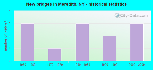
- New bridges - historical statistics
- 31960-1969
- 11970-1979
- 31980-1989
- 21990-1999
- 32000-2009

- Bridge Condition - Deck
- 33.3%Very good
- 66.7%Good

- Bridge Condition - Superstructure
- 16.7%Excellent
- 25.0%Very good
- 33.3%Good
- 8.3%Satisfactory
- 16.7%Fair

- Bridge Condition - Substructure
- 33.3%Very good
- 16.7%Good
- 25.0%Satisfactory
- 25.0%Fair

- Bridge Condition - Channel
- 41.7%Good
- 33.3%Satisfactory
- 25.0%Fair
Find on map >> Show street view
Structure Number: 10199, Location: 7.5 MI NW JCT RTS 28 +10 (Lat: 42.366958, Lng: -74.953442), Route carried "on" structure: State highway 28, Year Built: 1991, Status: Open, Structure Length: 2.71m (8.89ft), Average Daily Traffic: 2,477 (year 2019), Truck Traffic: 8%, Average Future Daily Traffic: 2,500 (year 2040), Design Load: HS 20, Features Intersected: OULEOUT CREEK
Minimum Vertical Clearance: 30+ m (98+ ft), Kilometerpoint: 63.829, Lanes on structure: 2, Base Highway Network: Yes, Owner: State Highway Agency, Approaching Roadway Width: 8.5m (27.9ft), Material/Design: Steel, Design/Construction: Stringer/Multi-beam, Number Of Spans In Main Unit: 1, Length of Maximum Span: 25.9m (85.0ft), Curb-To-Curb Width: 10.1m (33.1ft), Out-to-Out Width: 10.7m (35.1ft)
Condition: Deck: Good, Superstructure: Good, Substructure: Good, Channel: Good, Operating Rating: 91.1 metric tons, Method Used To Determine Operating Rating: Field evaluation and documented engineering judgment, Inventory Rating: 32.7 metric tons, Method Used To Determine Inventory Rating: Field evaluation and documented engineering judgment, Structural Evaluation: Better than present minimum criteria, Deck Geometry: Meets minimum limits, Waterway Adequacy: Somewhat better than minimum adequacy, Approach Roadway Alignment: Equal to present desirable criteria, Length Of Structure Improvement: 2.71m (8.89ft), Designated Inspection Frequency: Every 24 months, Inspection Date: May 2021, Bridge Improvement Cost: $830,000, Roadway Improvement Cost: $486,000, Total Project Cost: $1,315,000 ( Estimate for 2021), Deck Structure Type: Concrete Cast-file-Place, Wearing Surface/Protective System: Wearing Surface: Integral Concrete, Deck Protection: Epoxy Coated Reinforcing
Find on map >> Show street view
Structure Number: 101991, Location: 11.2 Mi NW JCT SH28 & 10 (Lat: 42.376978, Lng: -74.996878), Route carried "on" structure: State highway 28, Year Built: 2005, Status: Open, Structure Length: 0.82m (2.69ft), Average Daily Traffic: 1,559 (year 2019), Truck Traffic: 10%, Average Future Daily Traffic: 1,573 (year 2040), Design Load: HS 25 or greater, Features Intersected: Houghtaling Creek
Minimum Vertical Clearance: 30+ m (98+ ft), Kilometerpoint: 67.835, Lanes on structure: 2, Base Highway Network: Yes, Owner: State Highway Agency, Approaching Roadway Width: 6.7m (22.0ft), Skew: 2 degrees, Material/Design: Concrete, Design/Construction: Frame, Number Of Spans In Main Unit: 1, Length of Maximum Span: 7.9m (25.9ft), Curb-To-Curb Width: 10.2m (33.5ft), Out-to-Out Width: 11.2m (36.7ft)
Condition: Deck: Good, Superstructure: Good, Substructure: Very good, Channel: Good, Operating Rating: 43.7 metric tons, Method Used To Determine Operating Rating: Load and Resistance Factor Rating (LRFR) rating reported by rating factor(RF) method using HL-93 loadings, Inventory Rating: 33.7 metric tons, Method Used To Determine Inventory Rating: Load and Resistance Factor Rating (LRFR) rating reported by rating factor(RF) method using HL-93 loadings, Structural Evaluation: Better than present minimum criteria, Deck Geometry: Somewhat better than minimum adequacy, Waterway Adequacy: Equal to present minimum criteria, Approach Roadway Alignment: Better than present minimum criteria, Length Of Structure Improvement: 0.82m (2.69ft), Designated Inspection Frequency: Every 24 months, Inspection Date: May 2021, Bridge Improvement Cost: $293,000, Roadway Improvement Cost: $172,000, Total Project Cost: $465,000 ( Estimate for 2021), Wearing Surface/Protective System: Wearing Surface: Bituminous
Find on map >> Show street view
Structure Number: 222689, Location: 3.7 MI SE OF DAVENPORT CT (Lat: 42.411981, Lng: -74.868564), Route carried "on" structure: Other road , Year Built: 2000, Status: Open, Structure Length: 0.91m (2.99ft), Average Daily Traffic: 130 (year 2019), Truck Traffic: 5%, Average Future Daily Traffic: 182 (year 2039), Design Load: HS 25 or greater, Features Intersected: SMALL STREAM, Facility Carried by Structure: W KORTRIGHT CH RD
Minimum Vertical Clearance: 30+ m (98+ ft), Kilometerpoint: 0.740, Lanes on structure: 2, Owner: County Highway Agency, Approaching Roadway Width: 6.1m (20.0ft), Skew: 4 degrees, Material/Design: Steel, Design/Construction: Stringer/Multi-beam, Number Of Spans In Main Unit: 1, Length of Maximum Span: 7.9m (25.9ft), Curb-To-Curb Width: 7.3m (24.0ft), Out-to-Out Width: 7.6m (24.9ft)
Condition: Deck: Very good, Superstructure: Excellent, Substructure: Very good, Channel: Fair, Operating Rating: 67.1 metric tons, Method Used To Determine Operating Rating: Load Factor (LF), Inventory Rating: 39.9 metric tons, Method Used To Determine Inventory Rating: Load Factor (LF), Structural Evaluation: Equal to present desirable criteria, Deck Geometry: Somewhat better than minimum adequacy, Waterway Adequacy: Meets minimum limits, Approach Roadway Alignment: Equal to present minimum criteria, Length Of Structure Improvement: 0.91m (2.99ft), Designated Inspection Frequency: Every 24 months, Inspection Date: November 2020, Bridge Improvement Cost: $137,000, Roadway Improvement Cost: $80,000, Total Project Cost: $217,000 ( Estimate for 2021), Deck Structure Type: Wood or Timber, Wearing Surface/Protective System: Wearing Surface: Bituminous, Membrane: Other
Find on map >> Show street view
Structure Number: 226652, Location: 0.9 MI NE OF MERIDALE (Lat: 42.373831, Lng: -74.939394), Route carried "on" structure: Other road , Year Built: 1980, Status: Open, Structure Length: 0.88m (2.89ft), Average Daily Traffic: 21 (year 2017), Truck Traffic: 5%, Average Future Daily Traffic: 29 (year 2037), Design Load: HS 20, Features Intersected: OULEOUT CREEK, Facility Carried by Structure: GRIMM ROAD
Minimum Vertical Clearance: 30+ m (98+ ft), Kilometerpoint: 0.177, Lanes on structure: 2, Owner: County Highway Agency, Approaching Roadway Width: 3.0m (9.8ft), Material/Design: Steel, Design/Construction: Stringer/Multi-beam, Number Of Spans In Main Unit: 1, Length of Maximum Span: 7.3m (24.0ft), Curb-To-Curb Width: 6.1m (20.0ft), Out-to-Out Width: 6.2m (20.3ft)
Condition: Deck: Good, Superstructure: Fair, Substructure: Good, Channel: Good, Operating Rating: 65.3 metric tons, Method Used To Determine Operating Rating: Load Factor (LF), Inventory Rating: 39.0 metric tons, Method Used To Determine Inventory Rating: Load Factor (LF), Structural Evaluation: Somewhat better than minimum adequacy, Deck Geometry: Somewhat better than minimum adequacy, Waterway Adequacy: Meets minimum limits, Approach Roadway Alignment: Better than present minimum criteria, Length Of Structure Improvement: 0.88m (2.89ft), Designated Inspection Frequency: Every 24 months, Inspection Date: October 2020, Bridge Improvement Cost: $199,000, Roadway Improvement Cost: $116,000, Total Project Cost: $315,000 ( Estimate for 2021), Deck Structure Type: Concrete Cast-file-Place, Wearing Surface/Protective System: Wearing Surface: Bituminous
Find on map >> Show street view
Structure Number: 322693, Location: 6.5 MI SE OF ONEONTA (Lat: 42.375956, Lng: -74.996922), Route carried "on" structure: Other road , Year Built: 1973, Status: Open, Structure Length: 1.04m (3.41ft), Average Daily Traffic: 81 (year 2017), Truck Traffic: 5%, Average Future Daily Traffic: 113 (year 2037), Design Load: HS 20, Features Intersected: OULEOUT CREEK, Facility Carried by Structure: WARNER HILL ROAD
Minimum Vertical Clearance: 30+ m (98+ ft), Kilometerpoint: 3.942, Lanes on structure: 2, Owner: County Highway Agency, Approaching Roadway Width: 6.1m (20.0ft), Material/Design: Steel, Design/Construction: Stringer/Multi-beam, Number Of Spans In Main Unit: 1, Length of Maximum Span: 9.4m (30.8ft), Curb-To-Curb Width: 7.9m (25.9ft), Out-to-Out Width: 8.5m (27.9ft)
Condition: Deck: Good, Superstructure: Satisfactory, Substructure: Fair, Channel: Fair, Operating Rating: 76.2 metric tons, Method Used To Determine Operating Rating: Load Factor (LF), Inventory Rating: 45.4 metric tons, Method Used To Determine Inventory Rating: Load Factor (LF), Structural Evaluation: Somewhat better than minimum adequacy, Deck Geometry: Equal to present minimum criteria, Waterway Adequacy: Meets minimum limits, Approach Roadway Alignment: Equal to present minimum criteria, Length Of Structure Improvement: 1.03m (3.38ft), Designated Inspection Frequency: Every 24 months, Inspection Date: September 2020, Bridge Improvement Cost: $404,000, Roadway Improvement Cost: $237,000, Total Project Cost: $641,000 ( Estimate for 2021), Deck Structure Type: Concrete Cast-file-Place, Wearing Surface/Protective System: Wearing Surface: Bituminous
Find on map >> Show street view
Structure Number: 335287, Location: IN EAST MEREDITH (Lat: 42.423411, Lng: -74.888828), Route carried "on" structure: County highway , Year Built: 1991, Status: Open, Structure Length: 1.34m (4.40ft), Average Daily Traffic: 1,154 (year 2020), Truck Traffic: 11%, Average Future Daily Traffic: 1,616 (year 2040), Design Load: HS 20+Mod, Features Intersected: KORTRIGHT CREEK, Facility Carried by Structure: COUNTY ROAD 10
Minimum Vertical Clearance: 30+ m (98+ ft), Kilometerpoint: 9.026, Lanes on structure: 2, Owner: County Highway Agency, Approaching Roadway Width: 6.7m (22.0ft), Material/Design: Prestressed concrete, Design/Construction: Box Beam or Girders - Multiple, Number Of Spans In Main Unit: 1, Length of Maximum Span: 13.1m (43.0ft), Curb-To-Curb Width: 8.0m (26.2ft), Out-to-Out Width: 8.6m (28.2ft)
Condition: Deck: Good, Superstructure: Fair, Substructure: Very good, Channel: Good, Operating Rating: 85.3 metric tons, Method Used To Determine Operating Rating: Load Factor (LF), Inventory Rating: 50.8 metric tons, Method Used To Determine Inventory Rating: Load Factor (LF), Structural Evaluation: Somewhat better than minimum adequacy, Deck Geometry: Meets minimum limits, Waterway Adequacy: Meets minimum limits, Approach Roadway Alignment: Equal to present desirable criteria, Length Of Structure Improvement: 1.34m (4.40ft), Designated Inspection Frequency: Every 24 months, Inspection Date: May 2021, Bridge Improvement Cost: $447,000, Roadway Improvement Cost: $262,000, Total Project Cost: $709,000 ( Estimate for 2021), Wearing Surface/Protective System: Wearing Surface: Bituminous
Find on map >> Show street view
Structure Number: 33529, Location: 4.3 MI NE OF DELHI (Lat: 42.351150, Lng: -74.864325), Route carried "on" structure: Other road , Year Built: 1967, Status: Open, Structure Length: 1.28m (4.20ft), Average Daily Traffic: 211 (year 2019), Truck Traffic: 4%, Average Future Daily Traffic: 295 (year 2039), Design Load: HS 20, Features Intersected: ELK CREEK, Facility Carried by Structure: ELK CREEK ROAD
Minimum Vertical Clearance: 30+ m (98+ ft), Kilometerpoint: 0.257, Lanes on structure: 2, Owner: County Highway Agency, Approaching Roadway Width: 8.5m (27.9ft), Material/Design: Steel, Design/Construction: Stringer/Multi-beam, Number Of Spans In Main Unit: 1, Length of Maximum Span: 12.1m (39.7ft), Curb-To-Curb Width: 7.9m (25.9ft), Out-to-Out Width: 8.9m (29.2ft)
Condition: Deck: Very good, Superstructure: Very good, Substructure: Fair, Channel: Satisfactory, Operating Rating: 66.2 metric tons, Method Used To Determine Operating Rating: Load Factor (LF), Inventory Rating: 39.0 metric tons, Method Used To Determine Inventory Rating: Load Factor (LF), Structural Evaluation: Somewhat better than minimum adequacy, Deck Geometry: Somewhat better than minimum adequacy, Waterway Adequacy: Somewhat better than minimum adequacy, Approach Roadway Alignment: Equal to present minimum criteria, Length Of Structure Improvement: 1.28m (4.20ft), Designated Inspection Frequency: Every 24 months, Inspection Date: July 2021, Bridge Improvement Cost: $366,000, Roadway Improvement Cost: $214,000, Total Project Cost: $581,000 ( Estimate for 2021), Deck Structure Type: Concrete Cast-file-Place, Wearing Surface/Protective System: Wearing Surface: Bituminous
Find on map >> Show street view
Structure Number: 335291, Location: 1.6 MI NE OF TREADWELL (Lat: 42.348528, Lng: -75.019694), Route carried "on" structure: Other road , Year Built: 1980, Status: Open, Structure Length: 1.43m (4.69ft), Average Daily Traffic: 100 (year 2019), Truck Traffic: 5%, Average Future Daily Traffic: 140 (year 2039), Design Load: HS 20, Features Intersected: S.BR.OULEOUT CRK, Facility Carried by Structure: WARNER HILL ROAD
Minimum Vertical Clearance: 30+ m (98+ ft), Kilometerpoint: 0.097, Lanes on structure: 2, Owner: County Highway Agency, Approaching Roadway Width: 6.1m (20.0ft), Skew: 3 degrees, Material/Design: Steel, Design/Construction: Stringer/Multi-beam, Number Of Spans In Main Unit: 1, Length of Maximum Span: 12.4m (40.7ft), Curb-To-Curb Width: 7.3m (24.0ft), Out-to-Out Width: 7.5m (24.6ft)
Condition: Deck: Good, Superstructure: Good, Substructure: Satisfactory, Channel: Satisfactory, Operating Rating: 37.2 metric tons, Method Used To Determine Operating Rating: Load Factor (LF), Inventory Rating: 21.8 metric tons, Method Used To Determine Inventory Rating: Load Factor (LF), Structural Evaluation: Equal to present minimum criteria, Deck Geometry: Equal to present minimum criteria, Waterway Adequacy: Meets minimum limits, Approach Roadway Alignment: Equal to present minimum criteria, Length Of Structure Improvement: 1.43m (4.69ft), Designated Inspection Frequency: Every 24 months, Inspection Date: September 2020, Bridge Improvement Cost: $572,000, Roadway Improvement Cost: $335,000, Total Project Cost: $907,000 ( Estimate for 2021), Deck Structure Type: Concrete Cast-file-Place, Wearing Surface/Protective System: Wearing Surface: Bituminous
Find on map >> Show street view
Structure Number: 335292, Location: 1.1 MI E OF MERIDALE (Lat: 42.368486, Lng: -74.976433), Route carried "on" structure: Other road , Year Built: 1980, Status: Open, Structure Length: 1.19m (3.90ft), Average Daily Traffic: 51 (year 2017), Truck Traffic: 5%, Average Future Daily Traffic: 71 (year 2037), Design Load: HS 20, Features Intersected: OULEOUT CREEK, Facility Carried by Structure: SMITH HILL ROAD
Minimum Vertical Clearance: 30+ m (98+ ft), Kilometerpoint: 3.218, Lanes on structure: 2, Owner: County Highway Agency, Approaching Roadway Width: 4.3m (14.1ft), Skew: 4 degrees, Material/Design: Steel, Design/Construction: Stringer/Multi-beam, Number Of Spans In Main Unit: 1, Length of Maximum Span: 10.6m (34.8ft), Curb-To-Curb Width: 7.3m (24.0ft), Out-to-Out Width: 7.5m (24.6ft)
Condition: Deck: Good, Superstructure: Good, Substructure: Satisfactory, Channel: Satisfactory, Inventory Rating: 66.2 metric tons, Method Used To Determine Inventory Rating: Load Factor (LF), Structural Evaluation: Equal to present minimum criteria, Deck Geometry: Equal to present minimum criteria, Waterway Adequacy: Meets minimum limits, Approach Roadway Alignment: Equal to present minimum criteria, Length Of Structure Improvement: 1.18m (3.87ft), Designated Inspection Frequency: Every 24 months, Inspection Date: September 2020, Bridge Improvement Cost: $472,000, Roadway Improvement Cost: $276,000, Total Project Cost: $748,000 ( Estimate for 2021), Deck Structure Type: Concrete Cast-file-Place, Wearing Surface/Protective System: Wearing Surface: Bituminous
Find on map >> Show street view
Structure Number: 335294, Location: .7 MI SE OF EAST MEREDITH (Lat: 42.417047, Lng: -74.873914), Route carried "on" structure: Other road , Year Built: 1968, Status: Open, Structure Length: 1.34m (4.40ft), Average Daily Traffic: 153 (year 2019), Truck Traffic: 5%, Average Future Daily Traffic: 214 (year 2039), Design Load: HS 20, Features Intersected: KORTRIGHT CREEK, Facility Carried by Structure: KELSO ROAD
Minimum Vertical Clearance: 30+ m (98+ ft), Kilometerpoint: 0.756, Lanes on structure: 2, Owner: County Highway Agency, Approaching Roadway Width: 5.5m (18.0ft), Skew: 3 degrees, Material/Design: Steel, Design/Construction: Stringer/Multi-beam, Number Of Spans In Main Unit: 1, Length of Maximum Span: 12.4m (40.7ft), Curb-To-Curb Width: 7.9m (25.9ft), Out-to-Out Width: 8.9m (29.2ft)
Condition: Deck: Good, Superstructure: Very good, Substructure: Fair, Channel: Satisfactory, Operating Rating: 46.3 metric tons, Method Used To Determine Operating Rating: Load Factor (LF), Inventory Rating: 27.2 metric tons, Method Used To Determine Inventory Rating: Load Factor (LF), Structural Evaluation: Somewhat better than minimum adequacy, Deck Geometry: Somewhat better than minimum adequacy, Waterway Adequacy: Meets minimum limits, Approach Roadway Alignment: Better than present minimum criteria, Length Of Structure Improvement: 1.34m (4.40ft), Designated Inspection Frequency: Every 24 months, Inspection Date: May 2021, Bridge Improvement Cost: $510,000, Roadway Improvement Cost: $299,000, Total Project Cost: $809,000 ( Estimate for 2021), Deck Structure Type: Concrete Cast-file-Place, Wearing Surface/Protective System: Wearing Surface: Bituminous
Find on map >> Show street view
Structure Number: 33535, Location: IN EAST MERIDITH (Lat: 42.420339, Lng: -74.888122), Route carried "on" structure: County highway , Year Built: 1969, Status: Open, Structure Length: 0.88m (2.89ft), Average Daily Traffic: 360 (year 2020), Truck Traffic: 12%, Average Future Daily Traffic: 504 (year 2040), Features Intersected: MINE BROOK, Facility Carried by Structure: COUNTY ROAD 10
Minimum Vertical Clearance: 30+ m (98+ ft), Kilometerpoint: 8.528, Lanes on structure: 2, Owner: County Highway Agency, Approaching Roadway Width: 6.1m (20.0ft), Skew: 4 degrees, Material/Design: Concrete, Design/Construction: Slab, Number Of Spans In Main Unit: 1, Length of Maximum Span: 7.3m (24.0ft), Curb-To-Curb Width: 8.5m (27.9ft), Out-to-Out Width: 9.5m (31.2ft)
Condition: Deck: Very good, Superstructure: Very good, Substructure: Satisfactory, Channel: Good, Operating Rating: 47.2 metric tons, Method Used To Determine Operating Rating: Allowable Stress (AS), Inventory Rating: 28.1 metric tons, Method Used To Determine Inventory Rating: Allowable Stress (AS), Structural Evaluation: Equal to present minimum criteria, Deck Geometry: Equal to present minimum criteria, Waterway Adequacy: Somewhat better than minimum adequacy, Approach Roadway Alignment: Better than present minimum criteria, Length Of Structure Improvement: 0.88m (2.89ft), Designated Inspection Frequency: Every 24 months, Inspection Date: May 2021, Bridge Improvement Cost: $352,000, Roadway Improvement Cost: $206,000, Total Project Cost: $559,000 ( Estimate for 2021), Wearing Surface/Protective System: Wearing Surface: Bituminous
Find on map >> Show street view
Structure Number: 336041, Location: 2.5 MI EAST OF TREADWELL (Lat: 42.347853, Lng: -75.006869), Route carried "on" structure: Other road , Year Built: 2006, Status: Open, Structure Length: 1.34m (4.40ft), Average Daily Traffic: 50 (year 2019), Truck Traffic: 5%, Average Future Daily Traffic: 70 (year 2039), Features Intersected: S. BR. OULEOUT CRK, Facility Carried by Structure: TURNPIKE ROAD
Minimum Vertical Clearance: 30+ m (98+ ft), Kilometerpoint: 0.048, Lanes on structure: 2, Owner: County Highway Agency, Approaching Roadway Width: 7.3m (24.0ft), Material/Design: Steel, Design/Construction: Stringer/Multi-beam, Number Of Spans In Main Unit: 1, Length of Maximum Span: 8.2m (26.9ft), Curb-To-Curb Width: 7.3m (24.0ft), Out-to-Out Width: 7.6m (24.9ft)
Condition: Deck: Very good, Superstructure: Excellent, Substructure: Very good, Channel: Fair, Operating Rating: 87.1 metric tons, Method Used To Determine Operating Rating: Load Factor (LF), Inventory Rating: 51.7 metric tons, Method Used To Determine Inventory Rating: Load Factor (LF), Structural Evaluation: Equal to present desirable criteria, Deck Geometry: Equal to present minimum criteria, Waterway Adequacy: Somewhat better than minimum adequacy, Approach Roadway Alignment: Equal to present minimum criteria, Length Of Structure Improvement: 1.34m (4.40ft), Designated Inspection Frequency: Every 24 months, Inspection Date: October 2020, Bridge Improvement Cost: $275,000, Roadway Improvement Cost: $161,000, Total Project Cost: $435,000 ( Estimate for 2021), Deck Structure Type: Wood or Timber, Wearing Surface/Protective System: Wearing Surface: Bituminous, Membrane: Other