Bridge Statistics for Mesita, New Mexico (NM)
Condition, Traffic, Stress, Structural Evaluation, Project Costs
- National Bridge Inventory (NBI) Statistics
- 14Number of bridges
- 187ft / 57.1mTotal length
- $1,170,000Total costs
- 185,952Total average daily traffic
- 67,733Total average daily truck traffic
- National Bridge Inventory (NBI) Registered Bridges for Mesita
- No street view available for this location
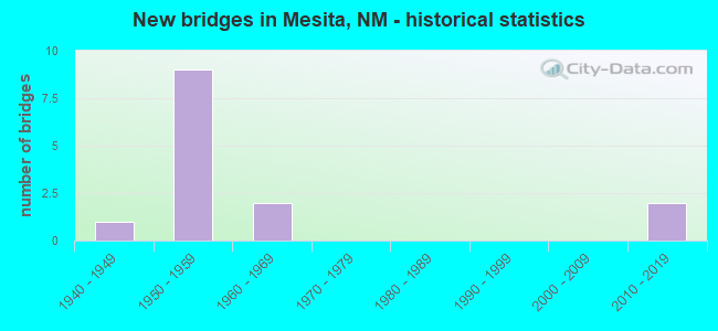
- New bridges - historical statistics
- 11940-1949
- 91950-1959
- 21960-1969
- 22010-2019

- Reconstructed bridges - Historical Statistics
- 41980-1989
- 01990-1999
- 02000-2009
- 22010-2019


- Bridge Condition - Deck
- 11.1%Very good
- 55.6%Good
- 33.3%Satisfactory

- Bridge Condition - Superstructure
- 11.1%Very good
- 44.4%Good
- 33.3%Satisfactory
- 11.1%Poor

- Bridge Condition - Substructure
- 11.1%Very good
- 44.4%Good
- 44.4%Fair

- Bridge Condition - Channel
- 16.7%Very good
- 83.3%Good
Find on map >> Show street view
Structure Number: 411, Location: 3.40 MI N OF JCT US-64 (Lat: 36.693147, Lng: -105.978708), Route carried "on" structure: US 285, Year Built: 1940, Status: Open, Structure Length: 1.32m (4.33ft), Average Daily Traffic: 1,393 (year 2020), Truck Traffic: 16%, Average Future Daily Traffic: 1,044 (year 2040), Design Load: H 15, Features Intersected: UNNAMED WATERWAY
Minimum Vertical Clearance: 30+ m (98+ ft), Kilometerpoint: 623.461, Lanes on structure: 2, Base Highway Network: Yes, Owner: State Highway Agency, Approaching Roadway Width: 7.9m (25.9ft), Material/Design: Concrete continuous, Design/Construction: Culvert, Number Of Spans In Main Unit: 4, Length of Maximum Span: 3.0m (9.8ft)
Condition: Channel: Good, Culverts: Good, Operating Rating: 82.6 metric tons, Method Used To Determine Operating Rating: Load Factor (LF), Inventory Rating: 24.3 metric tons, Method Used To Determine Inventory Rating: Load Factor (LF), Structural Evaluation: Equal to present minimum criteria, Waterway Adequacy: Superior to present desirable criteria, Approach Roadway Alignment: Equal to present desirable criteria, Length Of Structure Improvement: 1.34m (4.40ft), Designated Inspection Frequency: Every 48 months, Inspection Date: May 2020, Bridge Improvement Cost: $88,000, Roadway Improvement Cost: $8,000, Total Project Cost: $132,000 ( Estimate for 2030)
Find on map >> Show street view
Structure Number: 5986, Location: 5.0 MI W OF NM-6 (Lat: 34.993119, Lng: -107.257356), Route carried "on" structure: Interstate 40, Year Built: 1959, Year Reconstructed: 1987, Status: Open, Structure Length: 8.22m (26.97ft), Average Daily Traffic: 23,096 (year 2020), Truck Traffic: 37%, Average Future Daily Traffic: 39,538 (year 2040), Design Load: HS 20, Features Intersected: BNSF Railroad
Minimum Vertical Clearance: 30+ m (98+ ft), Kilometerpoint: 196.105, Lanes on structure: 2, Base Highway Network: Yes, Owner: State Highway Agency, Approaching Roadway Width: 12.2m (40.0ft), Skew: 16 degrees, Material/Design: Steel continuous, Design/Construction: Stringer/Multi-beam, Number Of Spans In Main Unit: 3, Length of Maximum Span: 31.1m (102.0ft), Curb-To-Curb Width: 11.6m (38.1ft), Out-to-Out Width: 12.3m (40.4ft)
Condition: Deck: Satisfactory, Superstructure: Satisfactory, Substructure: Fair, Operating Rating: 53.9 metric tons, Method Used To Determine Operating Rating: Load Factor (LF), Inventory Rating: 32.7 metric tons, Method Used To Determine Inventory Rating: Load Factor (LF), Structural Evaluation: Somewhat better than minimum adequacy, Deck Geometry: Equal to present minimum criteria, Underclear: Equal to present minimum criteria, Approach Roadway Alignment: Equal to present desirable criteria, Designated Inspection Frequency: Every 24 months, Inspection Date: November 2020, Deck Structure Type: Concrete Cast-file-Place
Find on map >> Show street view
Structure Number: 5987, Location: 5.0 MI W OF NM-6 (Lat: 34.993386, Lng: -107.257847), Route carried "on" structure: Interstate 40, Year Built: 1959, Year Reconstructed: 1987, Status: Open, Structure Length: 8.22m (26.97ft), Average Daily Traffic: 23,096 (year 2020), Truck Traffic: 37%, Average Future Daily Traffic: 39,538 (year 2040), Design Load: HS 20, Features Intersected: BNSF Railroad
Minimum Vertical Clearance: 30+ m (98+ ft), Kilometerpoint: 196.046, Lanes on structure: 2, Base Highway Network: Yes, Owner: State Highway Agency, Approaching Roadway Width: 11.9m (39.0ft), Skew: 16 degrees, Material/Design: Steel continuous, Design/Construction: Stringer/Multi-beam, Number Of Spans In Main Unit: 3, Length of Maximum Span: 31.1m (102.0ft), Curb-To-Curb Width: 11.6m (38.1ft), Out-to-Out Width: 12.3m (40.4ft)
Condition: Deck: Satisfactory, Superstructure: Satisfactory, Substructure: Fair, Operating Rating: 53.9 metric tons, Method Used To Determine Operating Rating: Load Factor (LF), Inventory Rating: 32.7 metric tons, Method Used To Determine Inventory Rating: Load Factor (LF), Structural Evaluation: Somewhat better than minimum adequacy, Deck Geometry: Equal to present minimum criteria, Underclear: Equal to present minimum criteria, Approach Roadway Alignment: Equal to present desirable criteria, Designated Inspection Frequency: Every 24 months, Inspection Date: November 2020, Deck Structure Type: Concrete Cast-file-Place, Wearing Surface/Protective System: Deck Protection: Epoxy Coated Reinforcing
Find on map >> Show street view
Structure Number: 6121, Location: I-40 @ MESITA I/C MP117 (Lat: 35.011883, Lng: -107.321942), Route carried "on" structure: State highway 4012, Year Built: 1959, Year Reconstructed: 1987, Status: Open, Structure Length: 7.19m (23.59ft), Average Daily Traffic: 753 (year 2020), Truck Traffic: 20%, Average Future Daily Traffic: 1,093 (year 2040), Design Load: HS 20, Features Intersected: I-40 EBL/WBL @ mp 117.93
Minimum Vertical Clearance: 30+ m (98+ ft), Kilometerpoint: 0.005, Lanes on structure: 2, Lanes under structure: 4, Owner: State Highway Agency, Approaching Roadway Width: 11.1m (36.4ft), Material/Design: Prestressed concrete, Design/Construction: Box Beam or Girders - Multiple, Number Of Spans In Main Unit: 4, Length of Maximum Span: 19.8m (65.0ft), Curb or Sidewalk Widths: Left: 1.8m (5.9ft), Right: 0.0m, Curb-To-Curb Width: 11.1m (36.4ft), Out-to-Out Width: 11.6m (38.1ft)
Condition: Deck: Good, Superstructure: Good, Substructure: Good, Operating Rating: 77.2 metric tons, Method Used To Determine Operating Rating: Load Factor (LF), Inventory Rating: 40.7 metric tons, Method Used To Determine Inventory Rating: Load Factor (LF), Structural Evaluation: Better than present minimum criteria, Deck Geometry: Better than present minimum criteria, Underclear: Somewhat better than minimum adequacy, Approach Roadway Alignment: Equal to present desirable criteria, Length Of Structure Improvement: 7.19m (23.59ft), Designated Inspection Frequency: Every 24 months, Inspection Date: June 2020, Bridge Improvement Cost: $358,000, Roadway Improvement Cost: $35,000, Total Project Cost: $538,000 ( Estimate for 2020), Deck Structure Type: Concrete Cast-file-Place, Wearing Surface/Protective System: Wearing Surface: Bituminous
Find on map >> Show street view
Structure Number: 6122, Location: 1.6 MI E OF EXIT-117 (Lat: 34.995739, Lng: -107.301322), Route carried "on" structure: State highway 4012, Year Built: 1959, Year Reconstructed: 1987, Status: Open, Structure Length: 7.19m (23.59ft), Average Daily Traffic: 162 (year 2020), Truck Traffic: 15%, Average Future Daily Traffic: 303 (year 2040), Design Load: HS 20, Features Intersected: I-40 EBL/WBL @ mp 119.35
Minimum Vertical Clearance: 30+ m (98+ ft), Kilometerpoint: 0.006, Lanes on structure: 2, Lanes under structure: 4, Owner: State Highway Agency, Approaching Roadway Width: 7.6m (24.9ft), Material/Design: Prestressed concrete, Design/Construction: Box Beam or Girders - Multiple, Number Of Spans In Main Unit: 4, Length of Maximum Span: 19.8m (65.0ft), Curb or Sidewalk Widths: Left: 0.5m (1.6ft), Right: 0.5m (1.6ft), Curb-To-Curb Width: 7.6m (24.9ft), Out-to-Out Width: 8.8m (28.9ft)
Condition: Deck: Good, Superstructure: Poor, Substructure: Fair, Operating Rating: 80.0 metric tons, Method Used To Determine Operating Rating: Load Factor (LF), Inventory Rating: 47.5 metric tons, Method Used To Determine Inventory Rating: Load Factor (LF), Structural Evaluation: Meets minimum limits, Deck Geometry: Somewhat better than minimum adequacy, Underclear: Somewhat better than minimum adequacy, Approach Roadway Alignment: Equal to present desirable criteria, Designated Inspection Frequency: Every 24 months, Inspection Date: June 2020, Deck Structure Type: Concrete Cast-file-Place, Wearing Surface/Protective System: Wearing Surface: Bituminous
Find on map >> Show street view
Structure Number: 6123, Location: 2.5 MI E OF EXIT-117 (Lat: 34.993742, Lng: -107.285675), Route carried "on" structure: Interstate 40, Year Built: 1959, Year Reconstructed: 2019, Status: Open, Structure Length: 4.97m (16.31ft), Average Daily Traffic: 23,096 (year 2020), Truck Traffic: 37%, Average Future Daily Traffic: 39,538 (year 2040), Design Load: HS 20, Features Intersected: RIO SAN JOSE
Minimum Vertical Clearance: 30+ m (98+ ft), Kilometerpoint: 193.556, Lanes on structure: 2, Base Highway Network: Yes, Owner: State Highway Agency, Approaching Roadway Width: 12.1m (39.7ft), Skew: 11 degrees, Material/Design: Prestressed concrete, Design/Construction: Stringer/Multi-beam, Number Of Spans In Main Unit: 3, Length of Maximum Span: 16.6m (54.5ft), Curb-To-Curb Width: 12.2m (40.0ft), Out-to-Out Width: 13.2m (43.3ft)
Condition: Deck: Good, Superstructure: Good, Substructure: Good, Channel: Good, Operating Rating: 64.0 metric tons, Method Used To Determine Operating Rating: Load Factor (LF), Inventory Rating: 37.1 metric tons, Method Used To Determine Inventory Rating: Load Factor (LF), Structural Evaluation: Better than present minimum criteria, Deck Geometry: Better than present minimum criteria, Waterway Adequacy: Equal to present desirable criteria, Approach Roadway Alignment: Equal to present desirable criteria, Designated Inspection Frequency: Every 24 months, Inspection Date: April 2020, Deck Structure Type: Concrete Cast-file-Place, Wearing Surface/Protective System: Deck Protection: Epoxy Coated Reinforcing
Find on map >> Show street view
Structure Number: 6124, Location: 2.5 MI E OF EXIT-117 (Lat: 34.993475, Lng: -107.285600), Route carried "on" structure: Interstate 40, Year Built: 1959, Year Reconstructed: 2019, Status: Open, Structure Length: 4.97m (16.31ft), Average Daily Traffic: 23,096 (year 2020), Truck Traffic: 37%, Average Future Daily Traffic: 39,538 (year 2040), Design Load: HS 20, Features Intersected: RIO SAN JOSE
Minimum Vertical Clearance: 30+ m (98+ ft), Kilometerpoint: 193.556, Lanes on structure: 2, Base Highway Network: Yes, Owner: State Highway Agency, Approaching Roadway Width: 12.2m (40.0ft), Skew: 11 degrees, Material/Design: Prestressed concrete, Design/Construction: Stringer/Multi-beam, Number Of Spans In Main Unit: 3, Length of Maximum Span: 16.8m (55.1ft), Curb-To-Curb Width: 12.3m (40.4ft), Out-to-Out Width: 13.2m (43.3ft)
Condition: Deck: Good, Superstructure: Good, Substructure: Good, Channel: Good, Operating Rating: 64.0 metric tons, Method Used To Determine Operating Rating: Load Factor (LF), Inventory Rating: 37.1 metric tons, Method Used To Determine Inventory Rating: Load Factor (LF), Structural Evaluation: Better than present minimum criteria, Deck Geometry: Better than present minimum criteria, Waterway Adequacy: Equal to present desirable criteria, Approach Roadway Alignment: Equal to present desirable criteria, Designated Inspection Frequency: Every 24 months, Inspection Date: April 2020, Deck Structure Type: Concrete Cast-file-Place, Wearing Surface/Protective System: Wearing Surface: Epoxy Overlay, Deck Protection: Epoxy Coated Reinforcing
Find on map >> Show street view
Structure Number: 6172, Location: 8.94 MI W OF JCT NM-6 (Lat: 35.009617, Lng: -107.319417), Route carried "on" structure: Interstate 40, Year Built: 1959, Status: Open, Structure Length: 0.72m (2.36ft), Average Daily Traffic: 23,096 (year 2020), Truck Traffic: 37%, Average Future Daily Traffic: 39,538 (year 2040), Design Load: HS 20, Features Intersected: UNNAMED WATERWAY
Minimum Vertical Clearance: 30+ m (98+ ft), Kilometerpoint: 189.797, Lanes on structure: 4, Base Highway Network: Yes, Owner: State Highway Agency, Approaching Roadway Width: 24.7m (81.0ft), Skew: 23 degrees, Material/Design: Concrete continuous, Design/Construction: Culvert, Number Of Spans In Main Unit: 2, Length of Maximum Span: 3.0m (9.8ft)
Condition: Channel: Good, Culverts: Good, Operating Rating: 89.1 metric tons, Method Used To Determine Operating Rating: Load Factor (LF), Inventory Rating: 32.4 metric tons, Method Used To Determine Inventory Rating: Load Factor (LF), Structural Evaluation: Better than present minimum criteria, Waterway Adequacy: Equal to present desirable criteria, Approach Roadway Alignment: Equal to present desirable criteria, Designated Inspection Frequency: Every 24 months, Inspection Date: December 2020
Find on map >> Show street view
Structure Number: 6491, Location: JCT I40/NM124 @ LAGUNA (Lat: 35.037883, Lng: -107.368389), Route carried "on" structure: State highway 124, Year Built: 1967, Status: Open, Structure Length: 7.13m (23.39ft), Average Daily Traffic: 1,946 (year 2020), Truck Traffic: 15%, Average Future Daily Traffic: 307 (year 2040), Design Load: HS 20, Features Intersected: I-40 EBL/WBL @ mp 114.2
Minimum Vertical Clearance: 30+ m (98+ ft), Kilometerpoint: 40.988, Lanes on structure: 2, Lanes under structure: 4, Owner: State Highway Agency, Approaching Roadway Width: 12.5m (41.0ft), Skew: 3 degrees, Material/Design: Steel continuous, Design/Construction: Stringer/Multi-beam, Number Of Spans In Main Unit: 4, Length of Maximum Span: 20.1m (65.9ft), Curb or Sidewalk Widths: Left: 0.2m (0.7ft), Right: 0.2m (0.7ft), Curb-To-Curb Width: 8.5m (27.9ft), Out-to-Out Width: 9.7m (31.8ft)
Condition: Deck: Satisfactory, Superstructure: Satisfactory, Substructure: Fair, Operating Rating: 61.6 metric tons, Method Used To Determine Operating Rating: Load Factor (LF), Inventory Rating: 32.4 metric tons, Method Used To Determine Inventory Rating: Load Factor (LF), Structural Evaluation: Somewhat better than minimum adequacy, Deck Geometry: Somewhat better than minimum adequacy, Underclear: High priority of corrective action, Approach Roadway Alignment: Equal to present desirable criteria, Length Of Structure Improvement: 7.13m (23.39ft), Designated Inspection Frequency: Every 24 months, Inspection Date: January 2022, Bridge Improvement Cost: $333,000, Roadway Improvement Cost: $33,000, Total Project Cost: $500,000 ( Estimate for 2020), Deck Structure Type: Concrete Cast-file-Place, Wearing Surface/Protective System: Wearing Surface: Epoxy Overlay
Find on map >> Show street view
Structure Number: M21707B0137, Location: 1.9 KM SW OF NM124/BIA502 (Lat: 35.032333, Lng: -107.397028), Route carried "on" structure: Federal lands road 503, Year Built: 2019, Status: Open, Structure Length: 4.02m (13.19ft), Average Daily Traffic: 500 (year 2021), Truck Traffic: 5%, Average Future Daily Traffic: 585 (year 2041), Design Load: HS 20, Features Intersected: RIO SAN JOSE
Minimum Vertical Clearance: 30+ m (98+ ft), Kilometerpoint: 9.200, Lanes on structure: 2, Owner: Bureau of Indian Affairs, Approaching Roadway Width: 9.8m (32.2ft), Material/Design: Prestressed concrete, Design/Construction: Stringer/Multi-beam, Number Of Spans In Main Unit: 1, Length of Maximum Span: 39.6m (129.9ft), Curb or Sidewalk Widths: Left: 4.1m (13.5ft), Right: 0.5m (1.6ft), Curb-To-Curb Width: 9.8m (32.2ft), Out-to-Out Width: 14.6m (47.9ft)
Condition: Deck: Good, Superstructure: Good, Substructure: Good, Channel: Good, Operating Rating: 79.0 metric tons, Method Used To Determine Operating Rating: Load and Resistance Factor (LRFR), Inventory Rating: 60.9 metric tons, Method Used To Determine Inventory Rating: Load and Resistance Factor (LRFR), Structural Evaluation: Better than present minimum criteria, Deck Geometry: Equal to present minimum criteria, Waterway Adequacy: Superior to present desirable criteria, Approach Roadway Alignment: Equal to present desirable criteria, Designated Inspection Frequency: Every 24 months, Inspection Date: April 2021, Deck Structure Type: Concrete Cast-file-Place
Find on map >> Show street view
Structure Number: M21707B0156, Location: .28 SM NE OF MESITA NM (Lat: 35.020025, Lng: -107.310950), Route carried "on" structure: Federal lands road , Year Built: 2010, Status: Open, Structure Length: 3.14m (10.30ft), Average Daily Traffic: 50 (year 2021), Truck Traffic: 2%, Average Future Daily Traffic: 52 (year 2041), Design Load: HS 25 or greater, Features Intersected: RIO SAN JOSE, Facility Carried by Structure: RED ROCK ROAD
Minimum Vertical Clearance: 99.90m (327.76ft), Kilometerpoint: 0.250, Lanes on structure: 1, Owner: Bureau of Indian Affairs, Approaching Roadway Width: 4.9m (16.1ft), Material/Design: Prestressed concrete, Design/Construction: Stringer/Multi-beam, Number Of Spans In Main Unit: 1, Length of Maximum Span: 29.6m (97.1ft), Curb or Sidewalk Widths: Left: 0.5m (1.6ft), Right: 0.5m (1.6ft), Curb-To-Curb Width: 4.9m (16.1ft), Out-to-Out Width: 4.9m (16.1ft)
Condition: Deck: Very good, Superstructure: Very good, Substructure: Very good, Channel: Very good, Inventory Rating: 52.1 metric tons, Method Used To Determine Inventory Rating: Load Factor (LF), Structural Evaluation: Equal to present desirable criteria, Deck Geometry: High priority of corrective action, Waterway Adequacy: Equal to present desirable criteria, Approach Roadway Alignment: Equal to present desirable criteria, Designated Inspection Frequency: Every 24 months, Inspection Date: November 2021, Deck Structure Type: Concrete Cast-file-Place, Wearing Surface/Protective System: Wearing Surface: Monolithic Concrete
Find on map >> Show street view
Structure Number: 6121, Location: I-40 @ MESITA I/C MP117 (Lat: 35.011883, Lng: -107.321942), Route carried "under" structure: Interstate 40, Year Built: 1959, Structure Length: 0. m, Average Daily Traffic: 21,283 (year 2020), Truck Traffic: 37%, Features Intersected: I-40 EBL/WBL @ mp 117.93
Minimum Vertical Clearance: 5.00m (16.40ft), Kilometerpoint: 189.458, Lanes on structure: 2, Lanes under structure: 4, Material/Design: Prestressed concrete, Design/Construction: Box Beam or Girders - Multiple, Length of Maximum Span: 19.8m (65.0ft)
Find on map >> Show street view
Structure Number: 6122, Location: 1.6 MI E OF EXIT-117 (Lat: 34.995739, Lng: -107.301322), Route carried "under" structure: Interstate 40, Year Built: 1959, Structure Length: 0. m, Average Daily Traffic: 23,096 (year 2020), Truck Traffic: 37%, Features Intersected: I-40 EBL/WBL @ mp 119.35
Minimum Vertical Clearance: 4.88m (16.01ft), Kilometerpoint: 192.075, Lanes on structure: 2, Lanes under structure: 4, Material/Design: Prestressed concrete, Design/Construction: Box Beam or Girders - Multiple, Length of Maximum Span: 19.8m (65.0ft)
Find on map >> Show street view
Structure Number: 6491, Location: JCT I40/NM124 @ LAGUNA (Lat: 35.037883, Lng: -107.368389), Route carried "under" structure: Interstate 40, Year Built: 1967, Structure Length: 0. m, Average Daily Traffic: 21,289 (year 2020), Truck Traffic: 37%, Features Intersected: I-40 EBL/WBL @ mp 114.2, Facility Carried by Structure: NM-124
Minimum Vertical Clearance: 5.27m (17.29ft), Kilometerpoint: 183.703, Lanes on structure: 2, Lanes under structure: 4, Material/Design: Steel continuous, Design/Construction: Stringer/Multi-beam, Length of Maximum Span: 20.1m (65.9ft)