Bridge Statistics for Methuen, Massachusetts (MA)
Condition, Traffic, Stress, Structural Evaluation, Project Costs
- National Bridge Inventory (NBI) Statistics
- 39Number of bridges
- 531ft / 162mTotal length
- $224,018,000Total costs
- 2,728,869Total average daily traffic
- 228,996Total average daily truck traffic
- National Bridge Inventory (NBI) Registered Bridges for Methuen
- No street view available for this location
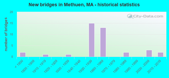
- New bridges - historical statistics
- 2Before 1900
- 11910-1919
- 11930-1939
- 151950-1959
- 131960-1969
- 21980-1989
- 32000-2009
- 22010-2019

- Reconstructed bridges - Historical Statistics
- 51960-1969
- 21970-1979
- 41980-1989
- 11990-1999
- 02000-2009
- 22010-2019


- Bridge Condition - Deck
- 19.4%Good
- 32.3%Satisfactory
- 45.2%Fair
- 3.2%Poor

- Bridge Condition - Superstructure
- 2.9%Very good
- 11.8%Good
- 32.4%Satisfactory
- 41.2%Fair
- 5.9%Poor
- 5.9%Serious

- Bridge Condition - Substructure
- 14.7%Good
- 41.2%Satisfactory
- 44.1%Fair

- Bridge Condition - Channel
- 10.0%Very good
- 20.0%Good
- 60.0%Satisfactory
- 10.0%Fair
Find on map >> Show street view
Structure Number: A090222V0DOTNBI, Location: AT MERRIMAC RIVER (Lat: 42.700633, Lng: -71.209858), Route carried "on" structure: Interstate 93, Year Built: 1959, Year Reconstructed: 1975, Status: Temporarily open, Structure Length: 23.62m (77.49ft), Average Daily Traffic: 129,908 (year 2016), Truck Traffic: 9%, Average Future Daily Traffic: 194,728 (year 2032), Design Load: HS 20+Mod, Features Intersected: WATER MERRIMACK RIVER
Minimum Vertical Clearance: 30+ m (98+ ft), Kilometerpoint: 69.948, Lanes on structure: 8, Base Highway Network: Yes, Owner: State Highway Agency, Approaching Roadway Width: 40.2m (131.9ft), Skew: 32 degrees, Material/Design: Steel continuous, Design/Construction: Girder and Floorbeam System, Number Of Spans In Main Unit: 5, Number Of Approach Spans: 1, Length of Maximum Span: 53.3m (174.9ft), Curb or Sidewalk Widths: Left: 2.3m (7.5ft), Right: 2.3m (7.5ft), Curb-To-Curb Width: 40.2m (131.9ft), Out-to-Out Width: 43.5m (142.7ft)
Condition: Deck: Fair, Superstructure: Poor, Substructure: Fair, Channel: Satisfactory, Operating Rating: 45.1 metric tons, Method Used To Determine Operating Rating: Load Factor (LF), Inventory Rating: 27.0 metric tons, Method Used To Determine Inventory Rating: Load Factor (LF), Structural Evaluation: Meets minimum limits, Deck Geometry: Superior to present desirable criteria, Waterway Adequacy: Superior to present desirable criteria, Approach Roadway Alignment: Equal to present desirable criteria, Length Of Structure Improvement: 23.40m (76.77ft), Designated Inspection Frequency: Every 12 months, Underwater Inspection Frequency: Every 36 months, Other Special Inspection Frequency: Every 12 months, Inspection Date: June 2021, Underwater Inspection Date: August 2019, Other Special Inspection Date: June 2021, Bridge Improvement Cost: $49,273,000, Roadway Improvement Cost: $4,928,000, Total Project Cost: $73,910,000 ( Estimate for 2022), Deck Structure Type: Concrete Cast-file-Place, Wearing Surface/Protective System: Wearing Surface: Bituminous, Membrane: Built-up
Find on map >> Show street view
Structure Number: A09029AU5DOTNBI, Location: .5 MILES SOUTH MERRIMAC R (Lat: 42.690583, Lng: -71.206389), Route carried "on" structure: State highway , Year Built: 2001, Status: Open, Structure Length: 6.76m (22.18ft), Average Daily Traffic: 13,941 (year 2017), Truck Traffic: 10%, Average Future Daily Traffic: 7,581 (year 2032), Design Load: HS 20, Features Intersected: I 93, Facility Carried by Structure: HWY RIVER RD
Minimum Vertical Clearance: 99.00m (324.80ft), Kilometerpoint: 5.488, Lanes on structure: 6, Lanes under structure: 6, Owner: State Highway Agency, Approaching Roadway Width: 25.6m (84.0ft), Skew: 20 degrees, Material/Design: Steel continuous, Design/Construction: Stringer/Multi-beam, Number Of Spans In Main Unit: 2, Length of Maximum Span: 33.8m (110.9ft), Curb or Sidewalk Widths: Left: 0.0m, Right: 1.8m (5.9ft), Curb-To-Curb Width: 25.6m (84.0ft), Out-to-Out Width: 28.3m (92.8ft)
Condition: Deck: Satisfactory, Superstructure: Satisfactory, Substructure: Satisfactory, Operating Rating: 67.0 metric tons, Method Used To Determine Operating Rating: Load Factor (LF), Inventory Rating: 40.1 metric tons, Method Used To Determine Inventory Rating: Load Factor (LF), Structural Evaluation: Equal to present minimum criteria, Deck Geometry: Somewhat better than minimum adequacy, Underclear: Superior to present desirable criteria, Approach Roadway Alignment: Equal to present desirable criteria, Length Of Structure Improvement: 6.80m (22.31ft), Designated Inspection Frequency: Every 24 months, Inspection Date: Febuary 2021, Bridge Improvement Cost: $2,501,000, Roadway Improvement Cost: $251,000, Total Project Cost: $3,752,000 ( Estimate for 2022), Deck Structure Type: Concrete Cast-file-Place, Wearing Surface/Protective System: Wearing Surface: Bituminous, Membrane: Built-up, Deck Protection: Epoxy Coated Reinforcing
Find on map >> Show street view
Structure Number: A090302XMDOTNBI, Location: AT I-495 (Lat: 42.649558, Lng: -71.216886), Route carried "on" structure: Interstate 495, Year Built: 1961, Year Reconstructed: 1987, Status: Open, Structure Length: 3.93m (12.89ft), Average Daily Traffic: 61,024 (year 2017), Truck Traffic: 10%, Average Future Daily Traffic: 168,669 (year 2032), Design Load: HS 20+Mod, Features Intersected: HWY HAGGETTS POND RD
Minimum Vertical Clearance: 30+ m (98+ ft), Kilometerpoint: 153.881, Lanes on structure: 3, Lanes under structure: 2, Base Highway Network: Yes, Owner: State Highway Agency, Approaching Roadway Width: 15.2m (49.9ft), Skew: 3 degrees, Material/Design: Steel, Design/Construction: Stringer/Multi-beam, Number Of Spans In Main Unit: 3, Length of Maximum Span: 16.2m (53.1ft), Curb-To-Curb Width: 15.2m (49.9ft), Out-to-Out Width: 17.4m (57.1ft)
Condition: Deck: Fair, Superstructure: Satisfactory, Substructure: Satisfactory, Operating Rating: 64.1 metric tons, Method Used To Determine Operating Rating: Allowable Stress (AS), Inventory Rating: 40.5 metric tons, Method Used To Determine Inventory Rating: Allowable Stress (AS), Structural Evaluation: Equal to present minimum criteria, Deck Geometry: Meets minimum limits, Underclear: Meets minimum limits, Approach Roadway Alignment: Equal to present desirable criteria, Length Of Structure Improvement: 4.00m (13.12ft), Designated Inspection Frequency: Every 24 months, Inspection Date: October 2020, Bridge Improvement Cost: $3,394,000, Roadway Improvement Cost: $340,000, Total Project Cost: $5,092,000 ( Estimate for 2022), Deck Structure Type: Concrete Cast-file-Place, Wearing Surface/Protective System: Wearing Surface: Bituminous, Membrane: Built-up, Deck Protection: Epoxy Coated Reinforcing
Find on map >> Show street view
Structure Number: A090302XNDOTNBI, Location: AT I-495 (Lat: 42.649111, Lng: -71.215917), Route carried "on" structure: Interstate 495, Year Built: 1961, Year Reconstructed: 1987, Status: Open, Structure Length: 3.93m (12.89ft), Average Daily Traffic: 60,500 (year 2018), Truck Traffic: 10%, Average Future Daily Traffic: 168,669 (year 2032), Design Load: HS 20+Mod, Features Intersected: HWY HAGGETTS POND RD
Minimum Vertical Clearance: 30+ m (98+ ft), Kilometerpoint: 153.881, Lanes on structure: 3, Lanes under structure: 2, Base Highway Network: Yes, Owner: State Highway Agency, Approaching Roadway Width: 15.2m (49.9ft), Skew: 3 degrees, Material/Design: Steel, Design/Construction: Stringer/Multi-beam, Number Of Spans In Main Unit: 3, Length of Maximum Span: 16.2m (53.1ft), Curb-To-Curb Width: 15.2m (49.9ft), Out-to-Out Width: 17.4m (57.1ft)
Condition: Deck: Satisfactory, Superstructure: Satisfactory, Substructure: Satisfactory, Operating Rating: 47.2 metric tons, Method Used To Determine Operating Rating: Allowable Stress (AS), Inventory Rating: 30.2 metric tons, Method Used To Determine Inventory Rating: Allowable Stress (AS), Structural Evaluation: Equal to present minimum criteria, Deck Geometry: Meets minimum limits, Underclear: Meets minimum limits, Approach Roadway Alignment: Equal to present desirable criteria, Length Of Structure Improvement: 4.00m (13.12ft), Designated Inspection Frequency: Every 24 months, Inspection Date: October 2021, Bridge Improvement Cost: $2,734,000, Roadway Improvement Cost: $274,000, Total Project Cost: $4,102,000 ( Estimate for 2022), Deck Structure Type: Concrete Cast-file-Place, Wearing Surface/Protective System: Wearing Surface: Bituminous, Membrane: Built-up, Deck Protection: Epoxy Coated Reinforcing
Find on map >> Show street view
Structure Number: M170012YLDOTNBI, Location: .9 MI S ST213 (Lat: 42.721597, Lng: -71.181875), Route carried "on" structure: State highway 28, Year Built: 1850, Status: Open, Structure Length: 0.85m (2.79ft), Average Daily Traffic: 11,300 (year 2017), Truck Traffic: 6%, Average Future Daily Traffic: 37,903 (year 2032), Features Intersected: WATER SPICKET RIVER
Minimum Vertical Clearance: 30+ m (98+ ft), Kilometerpoint: 240.338, Lanes on structure: 2, Base Highway Network: Yes, Owner: State Highway Agency, Approaching Roadway Width: 14.3m (46.9ft), Skew: 1 degrees, Material/Design: Masonry, Design/Construction: Arch - Deck, Number Of Spans In Main Unit: 1, Length of Maximum Span: 8.5m (27.9ft), Curb or Sidewalk Widths: Left: 2.4m (7.9ft), Right: 2.4m (7.9ft), Curb-To-Curb Width: 14.3m (46.9ft), Out-to-Out Width: 20.1m (65.9ft)
Condition: Superstructure: Satisfactory, Substructure: Fair, Channel: Good, Inventory Rating: 49.4 metric tons, Method Used To Determine Inventory Rating: Allowable Stress (AS), Structural Evaluation: Somewhat better than minimum adequacy, Deck Geometry: Superior to present desirable criteria, Waterway Adequacy: Equal to present desirable criteria, Approach Roadway Alignment: Equal to present desirable criteria, Length Of Structure Improvement: 0.90m (2.95ft), Designated Inspection Frequency: Every 24 months, Underwater Inspection Frequency: Every 36 months, Inspection Date: January 2021, Underwater Inspection Date: May 2019, Bridge Improvement Cost: $711,000, Roadway Improvement Cost: $72,000, Total Project Cost: $1,067,000 ( Estimate for 2022)
Find on map >> Show street view
Structure Number: M170022YMDOTNBI, Location: .6 MI S ST213 (Lat: 42.724692, Lng: -71.184367), Route carried "on" structure: State highway 28, Year Built: 1912, Status: Open, Structure Length: 2.44m (8.01ft), Average Daily Traffic: 22,000 (year 2018), Truck Traffic: 8%, Average Future Daily Traffic: 33,165 (year 2031), Features Intersected: WATER SPICKET RIVER
Minimum Vertical Clearance: 30+ m (98+ ft), Kilometerpoint: 240.740, Lanes on structure: 2, Base Highway Network: Yes, Owner: State Highway Agency, Approaching Roadway Width: 15.2m (49.9ft), Material/Design: Concrete, Design/Construction: Arch - Deck, Number Of Spans In Main Unit: 3, Length of Maximum Span: 5.5m (18.0ft), Curb or Sidewalk Widths: Left: 2.4m (7.9ft), Right: 2.4m (7.9ft), Curb-To-Curb Width: 15.2m (49.9ft), Out-to-Out Width: 21.3m (69.9ft)
Condition: Superstructure: Satisfactory, Substructure: Fair, Channel: Satisfactory, Operating Rating: 77.6 metric tons, Method Used To Determine Operating Rating: Load Factor (LF), Inventory Rating: 46.5 metric tons, Method Used To Determine Inventory Rating: Load Factor (LF), Structural Evaluation: Somewhat better than minimum adequacy, Deck Geometry: Superior to present desirable criteria, Waterway Adequacy: Equal to present desirable criteria, Approach Roadway Alignment: Equal to present desirable criteria, Length Of Structure Improvement: 2.50m (8.20ft), Designated Inspection Frequency: Every 24 months, Underwater Inspection Frequency: Every 36 months, Inspection Date: August 2020, Underwater Inspection Date: July 2019, Bridge Improvement Cost: $2,092,000, Roadway Improvement Cost: $210,000, Total Project Cost: $3,139,000 ( Estimate for 2022)
Find on map >> Show street view
Structure Number: M170032Q7MUNNBI, Location: .16 KM W ST 28 (Lat: 42.727256, Lng: -71.188300), Route carried "on" structure: City street , Year Built: 1869, Status: Open, Structure Length: 0.98m (3.22ft), Average Daily Traffic: 5,500 (year 2018), Truck Traffic: 11%, Average Future Daily Traffic: 18,162 (year 2031), Features Intersected: WATER SPICKET RIVER, Facility Carried by Structure: HWY OSGOOD ST
Minimum Vertical Clearance: 30+ m (98+ ft), Kilometerpoint: 0.290, Lanes on structure: 2, Owner: Town or Township Highway Agency, Approaching Roadway Width: 7.6m (24.9ft), Skew: 2 degrees, Material/Design: Masonry, Design/Construction: Arch - Deck, Number Of Spans In Main Unit: 1, Length of Maximum Span: 9.8m (32.2ft), Curb or Sidewalk Widths: Left: 1.5m (4.9ft), Right: 1.8m (5.9ft), Curb-To-Curb Width: 7.3m (24.0ft), Out-to-Out Width: 13.8m (45.3ft)
Condition: Superstructure: Satisfactory, Substructure: Satisfactory, Channel: Satisfactory, Structural Evaluation: Equal to present minimum criteria, Deck Geometry: High priority of replacement, Waterway Adequacy: Superior to present desirable criteria, Approach Roadway Alignment: Meets minimum limits, Length Of Structure Improvement: 1.00m (3.28ft), Designated Inspection Frequency: Every 24 months, Underwater Inspection Frequency: Every 36 months, Inspection Date: August 2020, Underwater Inspection Date: August 2020, Bridge Improvement Cost: $576,000, Roadway Improvement Cost: $58,000, Total Project Cost: $865,000 ( Estimate for 2022)
Find on map >> Show street view
Structure Number: M170052Q8MUNNBI, Location: JUST WEST ST 28 BROADWAY (Lat: 42.721467, Lng: -71.186353), Route carried "on" structure: City street , Year Built: 1936, Status: Open, Structure Length: 1.07m (3.51ft), Average Daily Traffic: 11,900 (year 2021), Truck Traffic: 2%, Average Future Daily Traffic: 6,791 (year 2032), Features Intersected: TR METHUEN RAIL TRAIL, Facility Carried by Structure: HWY OAKLAND AVE
Minimum Vertical Clearance: 30+ m (98+ ft), Kilometerpoint: 1.481, Lanes on structure: 2, Owner: City or Municipal Highway Agency, Approaching Roadway Width: 9.8m (32.2ft), Material/Design: Concrete, Design/Construction: Tee Beam, Number Of Spans In Main Unit: 1, Length of Maximum Span: 9.6m (31.5ft), Curb or Sidewalk Widths: Left: 1.8m (5.9ft), Right: 1.8m (5.9ft), Curb-To-Curb Width: 9.4m (30.8ft), Out-to-Out Width: 13.7m (44.9ft)
Condition: Deck: Fair, Superstructure: Fair, Substructure: Satisfactory, Operating Rating: 27.5 metric tons, Method Used To Determine Operating Rating: Load Factor (LF), Inventory Rating: 21.5 metric tons, Method Used To Determine Inventory Rating: Load Factor (LF), Structural Evaluation: Somewhat better than minimum adequacy, Deck Geometry: High priority of corrective action, Approach Roadway Alignment: Somewhat better than minimum adequacy, Bridge Posting: Required (Relationship of Operating Rating to Maximum Legal Load: 10.0 - 19.9% below), Length Of Structure Improvement: 1.10m (3.61ft), Designated Inspection Frequency: Every 24 months, Inspection Date: December 2021, Bridge Improvement Cost: $592,000, Roadway Improvement Cost: $60,000, Total Project Cost: $889,000 ( Estimate for 2022), Deck Structure Type: Concrete Cast-file-Place, Wearing Surface/Protective System: Wearing Surface: Bituminous
Find on map >> Show street view
Structure Number: M1700632HDOT634, Location: .32 KM W ST28 (Lat: 42.726361, Lng: -71.190972), Route carried "on" structure: State highway 113, Year Built: 1983, Status: Open, Structure Length: 1.37m (4.49ft), Average Daily Traffic: 28,000 (year 2019), Truck Traffic: 7%, Average Future Daily Traffic: 24,163 (year 2032), Design Load: HS 20, Features Intersected: TR METHUEN RAILTRAIL
Minimum Vertical Clearance: 30+ m (98+ ft), Kilometerpoint: 46.712, Lanes on structure: 5, Owner: State Highway Agency, Approaching Roadway Width: 8.5m (27.9ft), Skew: 23 degrees, Material/Design: Prestressed concrete, Design/Construction: Box Beam or Girders - Multiple, Number Of Spans In Main Unit: 1, Length of Maximum Span: 13.1m (43.0ft), Curb or Sidewalk Widths: Left: 1.7m (5.6ft), Right: 1.5m (4.9ft), Curb-To-Curb Width: 31.1m (102.0ft), Out-to-Out Width: 49.5m (162.4ft)
Condition: Deck: Fair, Superstructure: Fair, Substructure: Fair, Operating Rating: 52.2 metric tons, Method Used To Determine Operating Rating: Load Factor (LF), Inventory Rating: 31.1 metric tons, Method Used To Determine Inventory Rating: Load Factor (LF), Structural Evaluation: Somewhat better than minimum adequacy, Deck Geometry: Superior to present desirable criteria, Underclear: High priority of corrective action, Approach Roadway Alignment: Equal to present desirable criteria, Length Of Structure Improvement: 1.40m (4.59ft), Designated Inspection Frequency: Every 24 months, Inspection Date: June 2021, Bridge Improvement Cost: $2,723,000, Roadway Improvement Cost: $273,000, Total Project Cost: $4,085,000 ( Estimate for 2022), Deck Structure Type: Concrete Precast Panels, Wearing Surface/Protective System: Wearing Surface: Bituminous, Membrane: Built-up
Find on map >> Show street view
Structure Number: M170072UPDOTNBI, Location: AT MERRIMAC RIVER (Lat: 42.702194, Lng: -71.210106), Route carried "on" structure: Interstate 93, Year Built: 1959, Year Reconstructed: 1975, Status: Open, Structure Length: 9.51m (31.20ft), Average Daily Traffic: 133,000 (year 2018), Truck Traffic: 12%, Average Future Daily Traffic: 207,591 (year 2032), Design Load: HS 20, Features Intersected: HWY RIVERSIDE DR
Minimum Vertical Clearance: 30+ m (98+ ft), Kilometerpoint: 70.211, Lanes on structure: 8, Lanes under structure: 2, Base Highway Network: Yes, Owner: State Highway Agency, Approaching Roadway Width: 40.2m (131.9ft), Skew: 22 degrees, Material/Design: Steel continuous, Design/Construction: Stringer/Multi-beam, Number Of Spans In Main Unit: 4, Length of Maximum Span: 25.3m (83.0ft), Curb-To-Curb Width: 40.2m (131.9ft), Out-to-Out Width: 43.5m (142.7ft)
Condition: Deck: Satisfactory, Superstructure: Satisfactory, Substructure: Satisfactory, Operating Rating: 62.6 metric tons, Method Used To Determine Operating Rating: Load Factor (LF), Inventory Rating: 37.5 metric tons, Method Used To Determine Inventory Rating: Load Factor (LF), Structural Evaluation: Equal to present minimum criteria, Deck Geometry: Superior to present desirable criteria, Underclear: Somewhat better than minimum adequacy, Approach Roadway Alignment: Better than present minimum criteria, Length Of Structure Improvement: 9.60m (31.50ft), Designated Inspection Frequency: Every 24 months, Inspection Date: October 2021, Bridge Improvement Cost: $3,281,000, Roadway Improvement Cost: $329,000, Total Project Cost: $4,922,000 ( Estimate for 2022), Deck Structure Type: Concrete Cast-file-Place, Wearing Surface/Protective System: Wearing Surface: Bituminous, Membrane: Built-up
Find on map >> Show street view
Structure Number: M17012AVTDOTNBI, Location: .1 MI W. ST 28 (Lat: 42.727361, Lng: -71.190339), Route carried "on" structure: State highway 113, Year Built: 2003, Status: Open, Structure Length: 1.28m (4.20ft), Average Daily Traffic: 12,025 (year 2018), Truck Traffic: 5%, Average Future Daily Traffic: 19,504 (year 2032), Design Load: HS 20+Mod, Features Intersected: WATER SPICKET RIVER
Minimum Vertical Clearance: 30+ m (98+ ft), Kilometerpoint: 46.557, Lanes on structure: 2, Owner: State Highway Agency, Approaching Roadway Width: 10.9m (35.8ft), Material/Design: Concrete, Design/Construction: Slab, Number Of Spans In Main Unit: 1, Length of Maximum Span: 0.0m, Curb or Sidewalk Widths: Left: 1.8m (5.9ft), Right: 1.8m (5.9ft), Curb-To-Curb Width: 10.9m (35.8ft), Out-to-Out Width: 15.8m (51.8ft)
Condition: Deck: Good, Superstructure: Good, Substructure: Good, Channel: Very good, Inventory Rating: 61.8 metric tons, Method Used To Determine Inventory Rating: Load Factor (LF), Structural Evaluation: Better than present minimum criteria, Deck Geometry: Meets minimum limits, Waterway Adequacy: Superior to present desirable criteria, Approach Roadway Alignment: Equal to present minimum criteria, Length Of Structure Improvement: 1.30m (4.27ft), Designated Inspection Frequency: Every 24 months, Inspection Date: May 2021, Bridge Improvement Cost: $307,000, Roadway Improvement Cost: $31,000, Total Project Cost: $461,000 ( Estimate for 2022), Deck Structure Type: Concrete Cast-file-Place, Wearing Surface/Protective System: Wearing Surface: Bituminous, Membrane: Built-up, Deck Protection: Epoxy Coated Reinforcing
Find on map >> Show street view
Structure Number: M17013AFGDOTNBI, Location: .1M WEST OF ST 28 (Lat: 42.727672, Lng: -71.190150), Route carried "on" structure: State highway 113, Year Built: 2003, Status: Open, Structure Length: 1.28m (4.20ft), Average Daily Traffic: 12,025 (year 2018), Truck Traffic: 5%, Average Future Daily Traffic: 19,504 (year 2032), Design Load: HS 20+Mod, Features Intersected: WATER SPICKET RIVER
Minimum Vertical Clearance: 30+ m (98+ ft), Kilometerpoint: 46.559, Lanes on structure: 2, Owner: State Highway Agency, Approaching Roadway Width: 10.9m (35.8ft), Material/Design: Concrete, Design/Construction: Slab, Number Of Spans In Main Unit: 1, Length of Maximum Span: 0.0m, Curb or Sidewalk Widths: Left: 1.8m (5.9ft), Right: 1.8m (5.9ft), Curb-To-Curb Width: 10.9m (35.8ft), Out-to-Out Width: 15.8m (51.8ft)
Condition: Deck: Good, Superstructure: Good, Substructure: Good, Channel: Good, Inventory Rating: 61.8 metric tons, Method Used To Determine Inventory Rating: Load Factor (LF), Structural Evaluation: Better than present minimum criteria, Deck Geometry: Meets minimum limits, Waterway Adequacy: Superior to present desirable criteria, Approach Roadway Alignment: Equal to present minimum criteria, Length Of Structure Improvement: 1.30m (4.27ft), Designated Inspection Frequency: Every 24 months, Inspection Date: May 2021, Bridge Improvement Cost: $307,000, Roadway Improvement Cost: $31,000, Total Project Cost: $461,000 ( Estimate for 2022), Deck Structure Type: Concrete Cast-file-Place, Wearing Surface/Protective System: Wearing Surface: Bituminous, Membrane: Built-up, Deck Protection: Epoxy Coated Reinforcing
Find on map >> Show street view
Structure Number: M1701631HDOTNBI, Location: 1.3 MI E ST28 (Lat: 42.742481, Lng: -71.168883), Route carried "on" structure: State highway , Year Built: 1961, Status: Open, Structure Length: 5.94m (19.49ft), Average Daily Traffic: 25,700 (year 2018), Truck Traffic: 10%, Average Future Daily Traffic: 33,576 (year 2031), Design Load: H 20, Features Intersected: ST213, Facility Carried by Structure: HWY HOWE ST
Minimum Vertical Clearance: 30+ m (98+ ft), Kilometerpoint: 0.032, Lanes on structure: 3, Lanes under structure: 4, Owner: State Highway Agency, Approaching Roadway Width: 12.2m (40.0ft), Material/Design: Prestressed concrete, Design/Construction: Stringer/Multi-beam, Number Of Spans In Main Unit: 4, Length of Maximum Span: 19.8m (65.0ft), Curb or Sidewalk Widths: Left: 0.5m (1.6ft), Right: 1.5m (4.9ft), Curb-To-Curb Width: 12.2m (40.0ft), Out-to-Out Width: 14.9m (48.9ft)
Condition: Deck: Fair, Superstructure: Fair, Substructure: Fair, Operating Rating: 68.0 metric tons, Method Used To Determine Operating Rating: Load Factor (LF), Inventory Rating: 40.7 metric tons, Method Used To Determine Inventory Rating: Load Factor (LF), Structural Evaluation: Somewhat better than minimum adequacy, Deck Geometry: Meets minimum limits, Underclear: Meets minimum limits, Approach Roadway Alignment: Equal to present desirable criteria, Length Of Structure Improvement: 6.00m (19.69ft), Designated Inspection Frequency: Every 24 months, Inspection Date: December 2020, Bridge Improvement Cost: $3,512,000, Roadway Improvement Cost: $352,000, Total Project Cost: $5,269,000 ( Estimate for 2022), Deck Structure Type: Concrete Cast-file-Place, Wearing Surface/Protective System: Wearing Surface: Bituminous, Membrane: Built-up
Find on map >> Show street view
Structure Number: M1701931JDOTNBI, Location: .6 MI N MERRIMAC RIVER (Lat: 42.710336, Lng: -71.211069), Route carried "on" structure: State highway , Year Built: 1959, Year Reconstructed: 1990, Status: Open, Structure Length: 12.74m (41.80ft), Average Daily Traffic: 3,750 (year 2018), Truck Traffic: 3%, Average Future Daily Traffic: 5,685 (year 2031), Design Load: H 20, Features Intersected: I 93, Facility Carried by Structure: HWY FOREST ST
Minimum Vertical Clearance: 30+ m (98+ ft), Kilometerpoint: 2.816, Lanes on structure: 2, Lanes under structure: 6, Owner: State Highway Agency, Approaching Roadway Width: 11.2m (36.7ft), Skew: 3 degrees, Material/Design: Steel continuous, Design/Construction: Stringer/Multi-beam, Number Of Spans In Main Unit: 4, Length of Maximum Span: 33.5m (109.9ft), Curb or Sidewalk Widths: Left: 1.9m (6.2ft), Right: 0.6m (2.0ft), Curb-To-Curb Width: 11.2m (36.7ft), Out-to-Out Width: 13.8m (45.3ft)
Condition: Deck: Fair, Superstructure: Satisfactory, Substructure: Satisfactory, Operating Rating: 66.9 metric tons, Method Used To Determine Operating Rating: Load Factor (LF), Inventory Rating: 40.1 metric tons, Method Used To Determine Inventory Rating: Load Factor (LF), Structural Evaluation: Equal to present minimum criteria, Deck Geometry: Somewhat better than minimum adequacy, Underclear: Meets minimum limits, Approach Roadway Alignment: Equal to present desirable criteria, Length Of Structure Improvement: 12.80m (41.99ft), Designated Inspection Frequency: Every 24 months, Inspection Date: December 2020, Bridge Improvement Cost: $8,206,000, Roadway Improvement Cost: $821,000, Total Project Cost: $12,310,000 ( Estimate for 2022), Deck Structure Type: Concrete Cast-file-Place, Wearing Surface/Protective System: Wearing Surface: Bituminous, Membrane: Built-up, Deck Protection: Epoxy Coated Reinforcing
Find on map >> Show street view
Structure Number: M170202UTDOTNBI, Location: 1.8 MI N MERRIMAC RIVER (Lat: 42.728406, Lng: -71.205106), Route carried "on" structure: Interstate 93, Year Built: 1959, Year Reconstructed: 1974, Status: Open, Structure Length: 3.75m (12.30ft), Average Daily Traffic: 114,140 (year 2017), Truck Traffic: 7%, Average Future Daily Traffic: 374,294 (year 2031), Design Load: HS 20+Mod, Features Intersected: HWY PELHAM ST
Minimum Vertical Clearance: 30+ m (98+ ft), Kilometerpoint: 73.334, Lanes on structure: 8, Lanes under structure: 2, Base Highway Network: Yes, Owner: State Highway Agency, Approaching Roadway Width: 61.9m (203.1ft), Skew: 30 degrees, Material/Design: Prestressed concrete, Design/Construction: Stringer/Multi-beam, Number Of Spans In Main Unit: 3, Length of Maximum Span: 17.1m (56.1ft), Curb or Sidewalk Widths: Left: 0.8m (2.6ft), Right: 0.8m (2.6ft), Curb-To-Curb Width: 61.9m (203.1ft), Out-to-Out Width: 65.0m (213.3ft)
Condition: Deck: Satisfactory, Superstructure: Satisfactory, Substructure: Fair, Operating Rating: 74.6 metric tons, Method Used To Determine Operating Rating: Load Factor (LF), Inventory Rating: 45.8 metric tons, Method Used To Determine Inventory Rating: Load Factor (LF), Structural Evaluation: Somewhat better than minimum adequacy, Deck Geometry: Superior to present desirable criteria, Underclear: Meets minimum limits, Approach Roadway Alignment: Equal to present desirable criteria, Length Of Structure Improvement: 3.80m (12.47ft), Designated Inspection Frequency: Every 24 months, Inspection Date: October 2020, Bridge Improvement Cost: $9,703,000, Roadway Improvement Cost: $971,000, Total Project Cost: $14,555,000 ( Estimate for 2022), Deck Structure Type: Concrete Cast-file-Place, Wearing Surface/Protective System: Wearing Surface: Bituminous, Membrane: Built-up
Find on map >> Show street view
Structure Number: M170212UUDOTNBI, Location: 2 MI N MERRIMAC RIVER (Lat: 42.731914, Lng: -71.203678), Route carried "on" structure: Interstate 93, Year Built: 1959, Year Reconstructed: 1974, Status: Open, Structure Length: 3.41m (11.19ft), Average Daily Traffic: 120,514 (year 2019), Truck Traffic: 7%, Average Future Daily Traffic: 136,294 (year 2031), Design Load: HS 20, Features Intersected: ST213 EB
Minimum Vertical Clearance: 30+ m (98+ ft), Kilometerpoint: 73.563, Lanes on structure: 6, Lanes under structure: 2, Base Highway Network: Yes, Owner: State Highway Agency, Approaching Roadway Width: 42.7m (140.1ft), Skew: 30 degrees, Material/Design: Prestressed concrete, Design/Construction: Stringer/Multi-beam, Number Of Spans In Main Unit: 3, Length of Maximum Span: 12.8m (42.0ft), Curb or Sidewalk Widths: Left: 0.8m (2.6ft), Right: 0.8m (2.6ft), Curb-To-Curb Width: 42.7m (140.1ft), Out-to-Out Width: 45.1m (148.0ft)
Condition: Deck: Fair, Superstructure: Fair, Substructure: Satisfactory, Operating Rating: 49.9 metric tons, Method Used To Determine Operating Rating: Load Factor (LF), Inventory Rating: 31.4 metric tons, Method Used To Determine Inventory Rating: Load Factor (LF), Structural Evaluation: Somewhat better than minimum adequacy, Deck Geometry: Superior to present desirable criteria, Underclear: Equal to present minimum criteria, Approach Roadway Alignment: Equal to present desirable criteria, Length Of Structure Improvement: 3.50m (11.48ft), Designated Inspection Frequency: Every 24 months, Inspection Date: October 2020, Bridge Improvement Cost: $6,201,000, Roadway Improvement Cost: $621,000, Total Project Cost: $9,302,000 ( Estimate for 2022), Deck Structure Type: Concrete Cast-file-Place, Wearing Surface/Protective System: Wearing Surface: Bituminous, Membrane: Built-up
Find on map >> Show street view
Structure Number: M17022AQ7DOTNBI, Location: .6 MILE E OF I 93 (Lat: 42.732681, Lng: -71.191292), Route carried "on" structure: State highway 28, Year Built: 2011, Status: Open, Structure Length: 5.04m (16.54ft), Average Daily Traffic: 38,147 (year 2019), Truck Traffic: 3%, Average Future Daily Traffic: 51,801 (year 2032), Design Load: HS 25 or greater, Features Intersected: ST213
Minimum Vertical Clearance: 30+ m (98+ ft), Kilometerpoint: 0.000, Lanes on structure: 4, Lanes under structure: 4, Base Highway Network: Yes, Owner: State Highway Agency, Approaching Roadway Width: 21.0m (68.9ft), Material/Design: Steel continuous, Design/Construction: Stringer/Multi-beam, Number Of Spans In Main Unit: 2, Length of Maximum Span: 25.2m (82.7ft), Curb or Sidewalk Widths: Left: 1.6m (5.2ft), Right: 0.0m, Curb-To-Curb Width: 21.0m (68.9ft), Out-to-Out Width: 23.3m (76.4ft)
Condition: Deck: Good, Superstructure: Good, Substructure: Good, Operating Rating: 66.0 metric tons, Method Used To Determine Operating Rating: Load Factor (LF), Inventory Rating: 39.5 metric tons, Method Used To Determine Inventory Rating: Load Factor (LF), Structural Evaluation: Better than present minimum criteria, Deck Geometry: Superior to present desirable criteria, Underclear: Superior to present desirable criteria, Approach Roadway Alignment: Equal to present desirable criteria, Length Of Structure Improvement: 5.10m (16.73ft), Designated Inspection Frequency: Every 24 months, Inspection Date: August 2021, Bridge Improvement Cost: $529,000, Roadway Improvement Cost: $53,000, Total Project Cost: $794,000 ( Estimate for 2022), Deck Structure Type: Concrete Cast-file-Place, Wearing Surface/Protective System: Wearing Surface: Bituminous, Membrane: Epoxy, Deck Protection: Epoxy Coated Reinforcing
Find on map >> Show street view
Structure Number: M170232UVDOTNBI, Location: 2.3 MI N MERRIMAC RIVER (Lat: 42.735128, Lng: -71.203614), Route carried "on" structure: Interstate 93, Year Built: 1959, Year Reconstructed: 1974, Status: Open, Structure Length: 3.99m (13.09ft), Average Daily Traffic: 120,514 (year 2019), Truck Traffic: 7%, Average Future Daily Traffic: 136,609 (year 2031), Design Load: HS 20+Mod, Features Intersected: ST213 WB
Minimum Vertical Clearance: 30+ m (98+ ft), Kilometerpoint: 73.754, Lanes on structure: 7, Lanes under structure: 2, Base Highway Network: Yes, Owner: State Highway Agency, Approaching Roadway Width: 41.5m (136.2ft), Skew: 20 degrees, Material/Design: Prestressed concrete, Design/Construction: Stringer/Multi-beam, Number Of Spans In Main Unit: 3, Length of Maximum Span: 14.9m (48.9ft), Curb or Sidewalk Widths: Left: 0.5m (1.6ft), Right: 0.5m (1.6ft), Curb-To-Curb Width: 41.5m (136.2ft), Out-to-Out Width: 42.7m (140.1ft)
Condition: Deck: Fair, Superstructure: Fair, Substructure: Fair, Operating Rating: 51.2 metric tons, Method Used To Determine Operating Rating: Load Factor (LF), Inventory Rating: 30.7 metric tons, Method Used To Determine Inventory Rating: Load Factor (LF), Structural Evaluation: Somewhat better than minimum adequacy, Deck Geometry: Superior to present desirable criteria, Underclear: Somewhat better than minimum adequacy, Approach Roadway Alignment: Equal to present desirable criteria, Length Of Structure Improvement: 4.00m (13.12ft), Designated Inspection Frequency: Every 24 months, Inspection Date: October 2020, Bridge Improvement Cost: $6,710,000, Roadway Improvement Cost: $672,000, Total Project Cost: $10,066,000 ( Estimate for 2022), Deck Structure Type: Concrete Cast-file-Place, Wearing Surface/Protective System: Wearing Surface: Bituminous, Membrane: Built-up
Find on map >> Show street view
Structure Number: M170242T0DOTNBI, Location: OVER SPICKET RIVER (Lat: 42.733750, Lng: -71.200333), Route carried "on" structure: State highway 213, Year Built: 1959, Year Reconstructed: 2018, Status: Open, Structure Length: 1.34m (4.40ft), Average Daily Traffic: 35,300 (year 2018), Truck Traffic: 10%, Average Future Daily Traffic: 100,286 (year 2031), Design Load: HL 93, Features Intersected: WATER SPICKET RIVER
Minimum Vertical Clearance: 30+ m (98+ ft), Kilometerpoint: 0.486, Lanes on structure: 2, Base Highway Network: Yes, Owner: State Highway Agency, Approaching Roadway Width: 11.6m (38.1ft), Material/Design: Steel, Design/Construction: Stringer/Multi-beam, Number Of Spans In Main Unit: 1, Length of Maximum Span: 12.2m (40.0ft), Curb-To-Curb Width: 11.6m (38.1ft), Out-to-Out Width: 13.8m (45.3ft)
Condition: Deck: Good, Superstructure: Satisfactory, Substructure: Satisfactory, Channel: Satisfactory, Operating Rating: 64.8 metric tons, Method Used To Determine Operating Rating: Load and Resistance Factor Rating (LRFR) rating reported by rating factor(RF) method using HL-93 loadings, Inventory Rating: 51.8 metric tons, Method Used To Determine Inventory Rating: Load and Resistance Factor Rating (LRFR) rating reported by rating factor(RF) method using HL-93 loadings, Structural Evaluation: Equal to present minimum criteria, Deck Geometry: Equal to present minimum criteria, Waterway Adequacy: Equal to present desirable criteria, Approach Roadway Alignment: Equal to present desirable criteria, Designated Inspection Frequency: Every 24 months, Underwater Inspection Frequency: Every 24 months, Inspection Date: August 2020, Underwater Inspection Date: December 2021, Deck Structure Type: Concrete Cast-file-Place, Wearing Surface/Protective System: Wearing Surface: Bituminous, Membrane: Built-up
Find on map >> Show street view
Structure Number: M170252RYDOTNBI, Location: OVER SPICKET RIVER (Lat: 42.731642, Lng: -71.200089), Route carried "on" structure: State highway 213, Year Built: 1959, Year Reconstructed: 2018, Status: Open, Structure Length: 1.28m (4.20ft), Average Daily Traffic: 35,000 (year 2018), Truck Traffic: 10%, Average Future Daily Traffic: 100,286 (year 2031), Design Load: HL 93, Features Intersected: WATER SPICKET RIVER
Minimum Vertical Clearance: 30+ m (98+ ft), Kilometerpoint: 0.486, Lanes on structure: 2, Base Highway Network: Yes, Owner: State Highway Agency, Approaching Roadway Width: 11.6m (38.1ft), Material/Design: Steel, Design/Construction: Stringer/Multi-beam, Number Of Spans In Main Unit: 1, Length of Maximum Span: 12.2m (40.0ft), Curb-To-Curb Width: 13.0m (42.7ft), Out-to-Out Width: 14.0m (45.9ft)
Condition: Deck: Good, Superstructure: Good, Substructure: Fair, Channel: Fair, Operating Rating: 61.6 metric tons, Method Used To Determine Operating Rating: Load and Resistance Factor Rating (LRFR) rating reported by rating factor(RF) method using HL-93 loadings, Inventory Rating: 48.6 metric tons, Method Used To Determine Inventory Rating: Load and Resistance Factor Rating (LRFR) rating reported by rating factor(RF) method using HL-93 loadings, Structural Evaluation: Somewhat better than minimum adequacy, Deck Geometry: Superior to present desirable criteria, Waterway Adequacy: Equal to present desirable criteria, Approach Roadway Alignment: Equal to present desirable criteria, Designated Inspection Frequency: Every 24 months, Underwater Inspection Frequency: Every 24 months, Inspection Date: August 2020, Underwater Inspection Date: December 2021, Deck Structure Type: Concrete Cast-file-Place, Wearing Surface/Protective System: Wearing Surface: Bituminous, Membrane: Built-up
Find on map >> Show street view
Structure Number: M170262RWDOTNBI, Location: .2 MI W ST28 (Lat: 42.731914, Lng: -71.195311), Route carried "on" structure: State highway 213, Year Built: 1959, Status: Open, Structure Length: 0.88m (2.89ft), Average Daily Traffic: 32,742 (year 2019), Truck Traffic: 10%, Average Future Daily Traffic: 59,540 (year 2031), Design Load: HS 20+Mod, Features Intersected: TR METHUEN RAIL TRAIL
Minimum Vertical Clearance: 30+ m (98+ ft), Kilometerpoint: 0.884, Lanes on structure: 2, Base Highway Network: Yes, Owner: State Highway Agency, Approaching Roadway Width: 12.2m (40.0ft), Skew: 1 degrees, Material/Design: Prestressed concrete, Design/Construction: Box Beam or Girders - Multiple, Number Of Spans In Main Unit: 1, Length of Maximum Span: 7.9m (25.9ft), Curb-To-Curb Width: 12.2m (40.0ft), Out-to-Out Width: 13.1m (43.0ft)
Condition: Deck: Poor, Superstructure: Poor, Substructure: Fair, Operating Rating: 50.6 metric tons, Method Used To Determine Operating Rating: Load Factor (LF), Inventory Rating: 30.3 metric tons, Method Used To Determine Inventory Rating: Load Factor (LF), Structural Evaluation: Meets minimum limits, Deck Geometry: Better than present minimum criteria, Approach Roadway Alignment: Equal to present desirable criteria, Length Of Structure Improvement: 1.60m (5.25ft), Designated Inspection Frequency: Every 12 months, Other Special Inspection Frequency: Every 12 months, Inspection Date: October 2020, Other Special Inspection Date: October 2021, Bridge Improvement Cost: $1,149,000, Roadway Improvement Cost: $115,000, Total Project Cost: $1,724,000 ( Estimate for 2022), Deck Structure Type: Concrete Precast Panels, Wearing Surface/Protective System: Wearing Surface: Bituminous, Membrane: Built-up
Find on map >> Show street view
Structure Number: M170262RXDOTNBI, Location: .2 MI W ST28 (Lat: 42.732050, Lng: -71.195381), Route carried "on" structure: State highway 213, Year Built: 1959, Status: Open, Structure Length: 0.88m (2.89ft), Average Daily Traffic: 33,600 (year 2018), Truck Traffic: 10%, Average Future Daily Traffic: 61,435 (year 2031), Design Load: HS 20+Mod, Features Intersected: TR METHUEN RAIL TRAIL
Minimum Vertical Clearance: 30+ m (98+ ft), Kilometerpoint: 0.884, Lanes on structure: 2, Base Highway Network: Yes, Owner: State Highway Agency, Approaching Roadway Width: 12.2m (40.0ft), Skew: 1 degrees, Material/Design: Prestressed concrete, Design/Construction: Box Beam or Girders - Multiple, Number Of Spans In Main Unit: 1, Length of Maximum Span: 7.9m (25.9ft), Curb-To-Curb Width: 12.2m (40.0ft), Out-to-Out Width: 13.1m (43.0ft)
Condition: Deck: Fair, Superstructure: Fair, Substructure: Fair, Operating Rating: 80.3 metric tons, Method Used To Determine Operating Rating: Load Factor (LF), Inventory Rating: 48.8 metric tons, Method Used To Determine Inventory Rating: Load Factor (LF), Structural Evaluation: Somewhat better than minimum adequacy, Deck Geometry: Better than present minimum criteria, Underclear: High priority of corrective action, Approach Roadway Alignment: Equal to present desirable criteria, Length Of Structure Improvement: 0.90m (2.95ft), Designated Inspection Frequency: Every 24 months, Inspection Date: October 2020, Bridge Improvement Cost: $464,000, Roadway Improvement Cost: $47,000, Total Project Cost: $697,000 ( Estimate for 2022), Deck Structure Type: Concrete Precast Panels, Wearing Surface/Protective System: Wearing Surface: Bituminous, Membrane: Built-up
Find on map >> Show street view
Structure Number: M170272UXDOTNBI, Location: .1 MI S NEW HAMPSHIRE STA (Lat: 42.742922, Lng: -71.209219), Route carried "on" structure: Interstate 93, Year Built: 1959, Year Reconstructed: 1974, Status: Open, Structure Length: 3.78m (12.40ft), Average Daily Traffic: 114,000 (year 2017), Truck Traffic: 6%, Average Future Daily Traffic: 146,875 (year 2031), Design Load: HS 20+Mod, Features Intersected: HWY HAMPSHIRE RD
Minimum Vertical Clearance: 30+ m (98+ ft), Kilometerpoint: 75.104, Lanes on structure: 6, Lanes under structure: 2, Base Highway Network: Yes, Owner: State Highway Agency, Approaching Roadway Width: 41.2m (135.2ft), Skew: 32 degrees, Material/Design: Prestressed concrete, Design/Construction: Stringer/Multi-beam, Number Of Spans In Main Unit: 3, Length of Maximum Span: 14.3m (46.9ft), Curb or Sidewalk Widths: Left: 0.5m (1.6ft), Right: 0.5m (1.6ft), Curb-To-Curb Width: 41.2m (135.2ft), Out-to-Out Width: 43.3m (142.1ft)
Condition: Deck: Satisfactory, Superstructure: Fair, Substructure: Satisfactory, Operating Rating: 45.2 metric tons, Method Used To Determine Operating Rating: Load Factor (LF), Inventory Rating: 31.8 metric tons, Method Used To Determine Inventory Rating: Load Factor (LF), Structural Evaluation: Somewhat better than minimum adequacy, Deck Geometry: Superior to present desirable criteria, Underclear: Meets minimum limits, Approach Roadway Alignment: Equal to present desirable criteria, Length Of Structure Improvement: 3.80m (12.47ft), Designated Inspection Frequency: Every 24 months, Inspection Date: October 2020, Bridge Improvement Cost: $6,464,000, Roadway Improvement Cost: $647,000, Total Project Cost: $9,697,000 ( Estimate for 2022), Deck Structure Type: Concrete Cast-file-Place, Wearing Surface/Protective System: Wearing Surface: Bituminous, Membrane: Built-up
Find on map >> Show street view
Structure Number: M1702831KDOTNBI, Location: .1 MILE EAST I 93 (Lat: 42.743000, Lng: -71.208361), Route carried "on" structure: State highway , Year Built: 1959, Status: Open, Structure Length: 1.13m (3.71ft), Average Daily Traffic: 4,900 (year 2018), Truck Traffic: 6%, Average Future Daily Traffic: 6,791 (year 2031), Design Load: H 20, Features Intersected: WATER SPICKET RIVER, Facility Carried by Structure: HWY HAMPSHIRE RD
Minimum Vertical Clearance: 30+ m (98+ ft), Kilometerpoint: 3.540, Lanes on structure: 2, Owner: State Highway Agency, Approaching Roadway Width: 9.1m (29.9ft), Skew: 3 degrees, Material/Design: Prestressed concrete, Design/Construction: Box Beam or Girders - Multiple, Number Of Spans In Main Unit: 1, Length of Maximum Span: 10.7m (35.1ft), Curb or Sidewalk Widths: Left: 1.5m (4.9ft), Right: 1.5m (4.9ft), Curb-To-Curb Width: 9.1m (29.9ft), Out-to-Out Width: 12.2m (40.0ft)
Condition: Deck: Fair, Superstructure: Fair, Substructure: Satisfactory, Channel: Satisfactory, Operating Rating: 59.0 metric tons, Method Used To Determine Operating Rating: Load Factor (LF), Inventory Rating: 47.0 metric tons, Method Used To Determine Inventory Rating: Load Factor (LF), Structural Evaluation: Somewhat better than minimum adequacy, Deck Geometry: Meets minimum limits, Waterway Adequacy: Equal to present desirable criteria, Approach Roadway Alignment: Equal to present desirable criteria, Length Of Structure Improvement: 1.20m (3.94ft), Designated Inspection Frequency: Every 24 months, Underwater Inspection Frequency: Every 36 months, Inspection Date: September 2020, Underwater Inspection Date: June 2021, Bridge Improvement Cost: $576,000, Roadway Improvement Cost: $58,000, Total Project Cost: $865,000 ( Estimate for 2022), Deck Structure Type: Concrete Precast Panels, Wearing Surface/Protective System: Wearing Surface: Bituminous, Membrane: Built-up
Find on map >> Show street view
Structure Number: M170292UWDOTNBI, Location: .32 KM S NEW HAMP STATE L (Lat: 42.740803, Lng: -71.207403), Route carried "on" structure: Interstate 93, Year Built: 1959, Year Reconstructed: 1972, Status: Open, Structure Length: 0.67m (2.20ft), Average Daily Traffic: 919,000 (year 2016), Truck Traffic: 10%, Average Future Daily Traffic: 157,930 (year 2031), Design Load: HS 20+Mod, Features Intersected: WATER HARRIS BROOK
Minimum Vertical Clearance: 30+ m (98+ ft), Kilometerpoint: 74.783, Lanes on structure: 3, Base Highway Network: Yes, Owner: State Highway Agency, Approaching Roadway Width: 30.5m (100.1ft), Skew: 20 degrees, Material/Design: Concrete, Design/Construction: Slab, Number Of Spans In Main Unit: 1, Length of Maximum Span: 6.4m (21.0ft), Curb-To-Curb Width: 42.4m (139.1ft), Out-to-Out Width: 44.0m (144.4ft)
Condition: Deck: Fair, Superstructure: Fair, Substructure: Satisfactory, Channel: Satisfactory, Operating Rating: 63.0 metric tons, Method Used To Determine Operating Rating: Load Factor (LF), Inventory Rating: 37.7 metric tons, Method Used To Determine Inventory Rating: Load Factor (LF), Structural Evaluation: Somewhat better than minimum adequacy, Deck Geometry: Superior to present desirable criteria, Waterway Adequacy: Superior to present desirable criteria, Approach Roadway Alignment: Equal to present desirable criteria, Length Of Structure Improvement: 0.70m (2.30ft), Designated Inspection Frequency: Every 24 months, Underwater Inspection Frequency: Every 36 months, Inspection Date: August 2020, Underwater Inspection Date: August 2019, Bridge Improvement Cost: $1,210,000, Roadway Improvement Cost: $122,000, Total Project Cost: $1,816,000 ( Estimate for 2022), Deck Structure Type: Concrete Cast-file-Place, Wearing Surface/Protective System: Wearing Surface: Bituminous, Membrane: Built-up
Find on map >> Show street view
Structure Number: M170312XGDOTNBI, Location: AT MERRIMAC RIVER (Lat: 42.753639, Lng: -71.129006), Route carried "on" structure: Interstate 495, Year Built: 1963, Status: Temporarily open, Structure Length: 5.22m (17.13ft), Average Daily Traffic: 63,100 (year 2019), Truck Traffic: 8%, Average Future Daily Traffic: 80,623 (year 2032), Design Load: HS 20+Mod, Features Intersected: ST110 /ST113/MERRIMACK
Minimum Vertical Clearance: 30+ m (98+ ft), Kilometerpoint: 169.282, Lanes on structure: 3, Lanes under structure: 2, Base Highway Network: Yes, Owner: State Highway Agency, Approaching Roadway Width: 15.2m (49.9ft), Skew: 6 degrees, Material/Design: Steel, Design/Construction: Stringer/Multi-beam, Number Of Spans In Main Unit: 3, Length of Maximum Span: 21.1m (69.2ft), Curb or Sidewalk Widths: Left: 0.5m (1.6ft), Right: 0.5m (1.6ft), Curb-To-Curb Width: 14.0m (45.9ft), Out-to-Out Width: 15.9m (52.2ft)
Condition: Deck: Satisfactory, Superstructure: Serious, Substructure: Fair, Operating Rating: 57.2 metric tons, Method Used To Determine Operating Rating: Load Factor (LF), Inventory Rating: 34.3 metric tons, Method Used To Determine Inventory Rating: Load Factor (LF), Structural Evaluation: High priority of corrective action, Deck Geometry: Meets minimum limits, Underclear: Meets minimum limits, Approach Roadway Alignment: Better than present minimum criteria, Length Of Structure Improvement: 5.30m (17.39ft), Designated Inspection Frequency: Every 6 months, Other Special Inspection Frequency: Every 6 months, Inspection Date: October 2021, Other Special Inspection Date: October 2021, Bridge Improvement Cost: $3,311,000, Roadway Improvement Cost: $332,000, Total Project Cost: $4,967,000 ( Estimate for 2022), Deck Structure Type: Concrete Cast-file-Place, Wearing Surface/Protective System: Wearing Surface: Bituminous, Membrane: Built-up
Find on map >> Show street view
Structure Number: M170312XHDOTNBI, Location: AT MERRIMAC RIVER (Lat: 42.753222, Lng: -71.128800), Route carried "on" structure: Interstate 495, Year Built: 1963, Status: Temporarily open, Structure Length: 5.26m (17.26ft), Average Daily Traffic: 65,820 (year 2019), Truck Traffic: 12%, Average Future Daily Traffic: 80,623 (year 2032), Design Load: HS 20+Mod, Features Intersected: ST110 /ST113/MERRIMACK
Minimum Vertical Clearance: 30+ m (98+ ft), Kilometerpoint: 169.282, Lanes on structure: 3, Lanes under structure: 2, Base Highway Network: Yes, Owner: State Highway Agency, Approaching Roadway Width: 15.2m (49.9ft), Material/Design: Steel, Design/Construction: Stringer/Multi-beam, Number Of Spans In Main Unit: 3, Length of Maximum Span: 21.3m (69.9ft), Curb or Sidewalk Widths: Left: 0.5m (1.6ft), Right: 0.5m (1.6ft), Curb-To-Curb Width: 14.0m (45.9ft), Out-to-Out Width: 15.9m (52.2ft)
Condition: Deck: Satisfactory, Superstructure: Serious, Substructure: Satisfactory, Operating Rating: 57.2 metric tons, Method Used To Determine Operating Rating: Load Factor (LF), Inventory Rating: 34.3 metric tons, Method Used To Determine Inventory Rating: Load Factor (LF), Structural Evaluation: High priority of corrective action, Deck Geometry: Meets minimum limits, Underclear: Somewhat better than minimum adequacy, Approach Roadway Alignment: Better than present minimum criteria, Length Of Structure Improvement: 5.30m (17.39ft), Designated Inspection Frequency: Every 6 months, Other Special Inspection Frequency: Every 6 months, Inspection Date: October 2021, Other Special Inspection Date: October 2021, Bridge Improvement Cost: $3,311,000, Roadway Improvement Cost: $332,000, Total Project Cost: $4,967,000 ( Estimate for 2022), Deck Structure Type: Concrete Cast-file-Place, Wearing Surface/Protective System: Wearing Surface: Bituminous, Membrane: Built-up
Find on map >> Show street view
Structure Number: M170322YFDOTNBI, Location: 1 MI S ST213 (Lat: 42.728178, Lng: -71.139028), Route carried "on" structure: State highway 110, Year Built: 1962, Status: Open, Structure Length: 10.79m (35.40ft), Average Daily Traffic: 46,414 (year 2016), Truck Traffic: 4%, Average Future Daily Traffic: 71,858 (year 2031), Design Load: H 20, Features Intersected: I 495
Minimum Vertical Clearance: 30+ m (98+ ft), Kilometerpoint: 77.262, Lanes on structure: 4, Lanes under structure: 6, Owner: State Highway Agency, Approaching Roadway Width: 14.6m (47.9ft), Skew: 3 degrees, Material/Design: Steel, Design/Construction: Stringer/Multi-beam, Number Of Spans In Main Unit: 5, Length of Maximum Span: 26.8m (87.9ft), Curb or Sidewalk Widths: Left: 1.8m (5.9ft), Right: 1.8m (5.9ft), Curb-To-Curb Width: 14.6m (47.9ft), Out-to-Out Width: 19.0m (62.3ft)
Condition: Deck: Fair, Superstructure: Fair, Substructure: Fair, Operating Rating: 52.5 metric tons, Method Used To Determine Operating Rating: Load Factor (LF), Inventory Rating: 32.1 metric tons, Method Used To Determine Inventory Rating: Load Factor (LF), Structural Evaluation: Somewhat better than minimum adequacy, Deck Geometry: High priority of replacement, Underclear: High priority of corrective action, Approach Roadway Alignment: Better than present minimum criteria, Length Of Structure Improvement: 10.80m (35.43ft), Designated Inspection Frequency: Every 24 months, Inspection Date: October 2020, Bridge Improvement Cost: $8,061,000, Roadway Improvement Cost: $807,000, Total Project Cost: $12,092,000 ( Estimate for 2022), Deck Structure Type: Concrete Cast-file-Place, Wearing Surface/Protective System: Wearing Surface: Bituminous, Membrane: Built-up
Find on map >> Show street view
Structure Number: M170332XEDOTNBI, Location: 1 MI N ST110 (Lat: 42.741531, Lng: -71.140958), Route carried "on" structure: Interstate 495, Year Built: 1964, Year Reconstructed: 1992, Status: Open, Structure Length: 5.46m (17.91ft), Average Daily Traffic: 61,657 (year 2020), Truck Traffic: 11%, Average Future Daily Traffic: 133,609 (year 2031), Design Load: H 20, Features Intersected: ST213
Minimum Vertical Clearance: 30+ m (98+ ft), Kilometerpoint: 167.647, Lanes on structure: 3, Lanes under structure: 4, Base Highway Network: Yes, Owner: State Highway Agency, Approaching Roadway Width: 15.8m (51.8ft), Skew: 2 degrees, Material/Design: Steel, Design/Construction: Stringer/Multi-beam, Number Of Spans In Main Unit: 4, Length of Maximum Span: 16.8m (55.1ft), Curb-To-Curb Width: 15.8m (51.8ft), Out-to-Out Width: 18.0m (59.1ft)
Condition: Deck: Satisfactory, Superstructure: Fair, Substructure: Good, Operating Rating: 62.6 metric tons, Method Used To Determine Operating Rating: Load Factor (LF), Inventory Rating: 37.5 metric tons, Method Used To Determine Inventory Rating: Load Factor (LF), Structural Evaluation: Somewhat better than minimum adequacy, Deck Geometry: Somewhat better than minimum adequacy, Underclear: Meets minimum limits, Approach Roadway Alignment: Equal to present desirable criteria, Length Of Structure Improvement: 5.50m (18.04ft), Designated Inspection Frequency: Every 24 months, Inspection Date: October 2020, Bridge Improvement Cost: $3,889,000, Roadway Improvement Cost: $389,000, Total Project Cost: $5,834,000 ( Estimate for 2022), Deck Structure Type: Concrete Cast-file-Place, Wearing Surface/Protective System: Wearing Surface: Bituminous, Membrane: Built-up, Deck Protection: Epoxy Coated Reinforcing
Find on map >> Show street view
Structure Number: M170332XFDOTNBI, Location: 1 MI N ST110 (Lat: 42.741839, Lng: -71.141414), Route carried "on" structure: Interstate 495, Year Built: 1964, Year Reconstructed: 1992, Status: Open, Structure Length: 5.52m (18.11ft), Average Daily Traffic: 50,326 (year 2020), Truck Traffic: 9%, Average Future Daily Traffic: 133,609 (year 2031), Design Load: HS 20, Features Intersected: ST213
Minimum Vertical Clearance: 30+ m (98+ ft), Kilometerpoint: 167.647, Lanes on structure: 3, Lanes under structure: 4, Base Highway Network: Yes, Owner: State Highway Agency, Approaching Roadway Width: 15.8m (51.8ft), Skew: 2 degrees, Material/Design: Steel, Design/Construction: Stringer/Multi-beam, Number Of Spans In Main Unit: 4, Length of Maximum Span: 16.5m (54.1ft), Curb-To-Curb Width: 15.2m (49.9ft), Out-to-Out Width: 17.1m (56.1ft)
Condition: Deck: Satisfactory, Superstructure: Fair, Substructure: Satisfactory, Operating Rating: 56.8 metric tons, Method Used To Determine Operating Rating: Load Factor (LF), Inventory Rating: 34.0 metric tons, Method Used To Determine Inventory Rating: Load Factor (LF), Structural Evaluation: Somewhat better than minimum adequacy, Deck Geometry: Meets minimum limits, Underclear: High priority of corrective action, Approach Roadway Alignment: Equal to present desirable criteria, Length Of Structure Improvement: 5.60m (18.37ft), Designated Inspection Frequency: Every 24 months, Inspection Date: October 2020, Bridge Improvement Cost: $3,762,000, Roadway Improvement Cost: $377,000, Total Project Cost: $5,644,000 ( Estimate for 2022), Deck Structure Type: Concrete Cast-file-Place, Wearing Surface/Protective System: Wearing Surface: Bituminous, Membrane: Built-up, Deck Protection: Epoxy Coated Reinforcing
Find on map >> Show street view
Structure Number: M1703530RDOTNBI, Location: .2 MI ST213 (Lat: 42.745294, Lng: -71.138747), Route carried "on" structure: State highway 113, Year Built: 1964, Status: Temporarily open, Structure Length: 9.48m (31.10ft), Average Daily Traffic: 12,341 (year 2016), Truck Traffic: 5%, Average Future Daily Traffic: 17,372 (year 2031), Design Load: H 20, Features Intersected: I 495
Minimum Vertical Clearance: 30+ m (98+ ft), Kilometerpoint: 51.573, Lanes on structure: 2, Lanes under structure: 6, Owner: State Highway Agency, Approaching Roadway Width: 14.6m (47.9ft), Skew: 4 degrees, Material/Design: Steel, Design/Construction: Stringer/Multi-beam, Number Of Spans In Main Unit: 5, Length of Maximum Span: 33.8m (110.9ft), Curb or Sidewalk Widths: Left: 1.5m (4.9ft), Right: 0.0m, Curb-To-Curb Width: 12.2m (40.0ft), Out-to-Out Width: 15.2m (49.9ft)
Condition: Deck: Satisfactory, Superstructure: Fair, Substructure: Fair, Operating Rating: 50.5 metric tons, Method Used To Determine Operating Rating: Load Factor (LF), Inventory Rating: 20.2 metric tons, Method Used To Determine Inventory Rating: Load Factor (LF), Structural Evaluation: Somewhat better than minimum adequacy, Deck Geometry: Somewhat better than minimum adequacy, Underclear: High priority of corrective action, Approach Roadway Alignment: Equal to present desirable criteria, Length Of Structure Improvement: 9.50m (31.17ft), Designated Inspection Frequency: Every 24 months, Inspection Date: October 2020, Bridge Improvement Cost: $5,673,000, Roadway Improvement Cost: $568,000, Total Project Cost: $8,510,000 ( Estimate for 2022), Deck Structure Type: Concrete Cast-file-Place, Wearing Surface/Protective System: Wearing Surface: Bituminous, Membrane: Built-up
Find on map >> Show street view
Structure Number: M1703730TDOTNBI, Location: .2 MI W I495 (Lat: 42.744419, Lng: -71.145269), Route carried "on" structure: State highway 113, Year Built: 1964, Status: Open, Structure Length: 7.13m (23.39ft), Average Daily Traffic: 13,200 (year 2019), Truck Traffic: 10%, Average Future Daily Traffic: 35,534 (year 2031), Design Load: HS 20, Features Intersected: ST213
Minimum Vertical Clearance: 30+ m (98+ ft), Kilometerpoint: 51.065, Lanes on structure: 2, Lanes under structure: 4, Owner: State Highway Agency, Approaching Roadway Width: 12.2m (40.0ft), Skew: 3 degrees, Material/Design: Steel, Design/Construction: Stringer/Multi-beam, Number Of Spans In Main Unit: 4, Length of Maximum Span: 24.4m (80.1ft), Curb or Sidewalk Widths: Left: 1.6m (5.2ft), Right: 0.0m, Curb-To-Curb Width: 12.2m (40.0ft), Out-to-Out Width: 14.9m (48.9ft)
Condition: Deck: Fair, Superstructure: Fair, Substructure: Fair, Operating Rating: 43.1 metric tons, Method Used To Determine Operating Rating: Load Factor (LF), Inventory Rating: 25.6 metric tons, Method Used To Determine Inventory Rating: Load Factor (LF), Structural Evaluation: Somewhat better than minimum adequacy, Deck Geometry: Somewhat better than minimum adequacy, Underclear: Meets minimum limits, Approach Roadway Alignment: Equal to present desirable criteria, Length Of Structure Improvement: 7.20m (23.62ft), Designated Inspection Frequency: Every 24 months, Inspection Date: October 2020, Bridge Improvement Cost: $4,214,000, Roadway Improvement Cost: $422,000, Total Project Cost: $6,322,000 ( Estimate for 2022), Deck Structure Type: Concrete Cast-file-Place, Wearing Surface/Protective System: Wearing Surface: Bituminous, Membrane: Built-up
Find on map >> Show street view
Structure Number: M170382T1DOTNBI, Location: .6 MI W I495 (Lat: 42.746389, Lng: -71.156806), Route carried "on" structure: State highway 213, Year Built: 1985, Status: Open, Structure Length: 5.21m (17.09ft), Average Daily Traffic: 12,700 (year 2018), Truck Traffic: 5%, Average Future Daily Traffic: 14,056 (year 2033), Design Load: HS 20, Features Intersected: ST213
Minimum Vertical Clearance: 30+ m (98+ ft), Kilometerpoint: 0.225, Lanes on structure: 2, Lanes under structure: 4, Base Highway Network: Yes, Owner: State Highway Agency, Approaching Roadway Width: 17.7m (58.1ft), Skew: 22 degrees, Material/Design: Steel, Design/Construction: Stringer/Multi-beam, Number Of Spans In Main Unit: 2, Length of Maximum Span: 24.7m (81.0ft), Curb-To-Curb Width: 17.7m (58.1ft), Out-to-Out Width: 18.7m (61.4ft)
Condition: Deck: Fair, Superstructure: Satisfactory, Substructure: Fair, Operating Rating: 55.1 metric tons, Method Used To Determine Operating Rating: Allowable Stress (AS), Inventory Rating: 35.3 metric tons, Method Used To Determine Inventory Rating: Allowable Stress (AS), Structural Evaluation: Somewhat better than minimum adequacy, Deck Geometry: Superior to present desirable criteria, Underclear: Better than present minimum criteria, Approach Roadway Alignment: Superior to present desirable criteria, Length Of Structure Improvement: 5.30m (17.39ft), Designated Inspection Frequency: Every 24 months, Inspection Date: January 2022, Bridge Improvement Cost: $3,894,000, Roadway Improvement Cost: $390,000, Total Project Cost: $5,842,000 ( Estimate for 2022), Deck Structure Type: Concrete Cast-file-Place, Wearing Surface/Protective System: Wearing Surface: Bituminous, Membrane: Preformed Fabric, Deck Protection: Epoxy Coated Reinforcing
Find on map >> Show street view
Structure Number: M17040BC4DOTNBI, Location: .9 MI N MERRIMAC RIVER (Lat: 42.705033, Lng: -71.210414), Route carried "on" structure: Interstate 93, Year Built: 2017, Status: Open, Structure Length: 6.05m (19.85ft), Average Daily Traffic: 112,881 (year 2020), Truck Traffic: 10%, Design Load: HL 93, Features Intersected: ST110 /ST113/LOWELL ST
Minimum Vertical Clearance: 30+ m (98+ ft), Kilometerpoint: 70.532, Lanes on structure: 8, Lanes under structure: 5, Base Highway Network: Yes, Owner: State Highway Agency, Approaching Roadway Width: 23.4m (76.8ft), Skew: 31 degrees, Material/Design: Steel continuous, Design/Construction: Stringer/Multi-beam, Number Of Spans In Main Unit: 2, Length of Maximum Span: 33.5m (109.9ft), Curb-To-Curb Width: 48.4m (158.8ft), Out-to-Out Width: 49.9m (163.7ft)
Condition: Deck: Good, Superstructure: Very good, Substructure: Good, Operating Rating: 42.1 metric tons, Method Used To Determine Operating Rating: Load and Resistance Factor Rating (LRFR) rating reported by rating factor(RF) method using HL-93 loadings, Inventory Rating: 32.4 metric tons, Method Used To Determine Inventory Rating: Load and Resistance Factor Rating (LRFR) rating reported by rating factor(RF) method using HL-93 loadings, Structural Evaluation: Better than present minimum criteria, Deck Geometry: Superior to present desirable criteria, Approach Roadway Alignment: Equal to present minimum criteria, Designated Inspection Frequency: Every 24 months, Inspection Date: December 2021, Deck Structure Type: Concrete Cast-file-Place, Wearing Surface/Protective System: Wearing Surface: Bituminous, Membrane: Epoxy
Find on map >> Show street view
Structure Number: M1701931JDOTNBI, Location: ENG JUDGE (Lat: 42.700000, Lng: -71.216667), Route carried "under" structure: Interstate 93, Year Built: 1959, Structure Length: 0. m, Average Daily Traffic: 40,000 (year 0000), Features Intersected: I 93 SB, Facility Carried by Structure: HWY FOREST ST
Minimum Vertical Clearance: 10.95m (35.93ft), Kilometerpoint: 71.163, Lanes on structure: 2, Lanes under structure: 2, Material/Design: Steel, Design/Construction: Stringer/Multi-beam, Length of Maximum Span: 33.5m (109.9ft)
Find on map >> Show street view
Structure Number: M1701931JDOTNBI, Location: .6 MI N MERRIMAC RIVER (Lat: 42.700000, Lng: -71.216667), Route carried "under" structure: Interstate 93, Year Built: 1959, Structure Length: 0. m, Average Daily Traffic: 40,000 (year 0000), Features Intersected: I 93 NB, Facility Carried by Structure: HWY FOREST ST
Minimum Vertical Clearance: 10.95m (35.93ft), Kilometerpoint: 71.163, Lanes on structure: 2, Lanes under structure: 2, Material/Design: Steel, Design/Construction: Stringer/Multi-beam, Length of Maximum Span: 33.5m (109.9ft)
Find on map >> Show street view
Structure Number: M170322YFDOTNBI, Location: 1 MI S ST213 (Lat: 42.733333, Lng: -71.133333), Route carried "under" structure: Interstate 495, Year Built: 1962, Structure Length: 0. m, Average Daily Traffic: 36,000 (year 0000), Features Intersected: I 495 SB, Facility Carried by Structure: ST110 MERRIMAC ST
Minimum Vertical Clearance: 5.00m (16.40ft), Kilometerpoint: 166.171, Lanes on structure: 3, Lanes under structure: 4, Material/Design: Steel, Design/Construction: Stringer/Multi-beam, Length of Maximum Span: 26.8m (87.9ft)
Find on map >> Show street view
Structure Number: M170322YFDOTNBI, Location: 1 MI S ST213 (Lat: 42.733333, Lng: -71.133333), Route carried "under" structure: Interstate 495, Year Built: 1962, Structure Length: 0. m, Average Daily Traffic: 36,000 (year 0000), Features Intersected: I 495 NB, Facility Carried by Structure: ST110 MERRIMAC ST
Minimum Vertical Clearance: 5.00m (16.40ft), Kilometerpoint: 166.171, Lanes on structure: 3, Lanes under structure: 4, Material/Design: Steel, Design/Construction: Stringer/Multi-beam, Length of Maximum Span: 26.8m (87.9ft)
Find on map >> Show street view
Structure Number: M1703530RDOTNBI, Location: .2 MI ST213 (Lat: 42.750000, Lng: -71.150000), Route carried "under" structure: Interstate 495, Year Built: 1964, Structure Length: 0. m, Average Daily Traffic: 40,000 (year 0000), Features Intersected: I 495 NB, Facility Carried by Structure: HWY PLSNT VLY ST
Minimum Vertical Clearance: 5.05m (16.57ft), Kilometerpoint: 168.167, Lanes on structure: 3, Lanes under structure: 2, Material/Design: Steel, Design/Construction: Stringer/Multi-beam, Length of Maximum Span: 33.8m (110.9ft)