Bridge Statistics for Mexico, New York (NY)
Condition, Traffic, Stress, Structural Evaluation, Project Costs
- National Bridge Inventory (NBI) Statistics
- 17Number of bridges
- 89ft / 26.9mTotal length
- $15,655,000Total costs
- 16,880Total average daily traffic
- 1,463Total average daily truck traffic
- 21,346Total future (year 2036) average daily traffic
- National Bridge Inventory (NBI) Registered Bridges for Mexico
- No street view available for this location
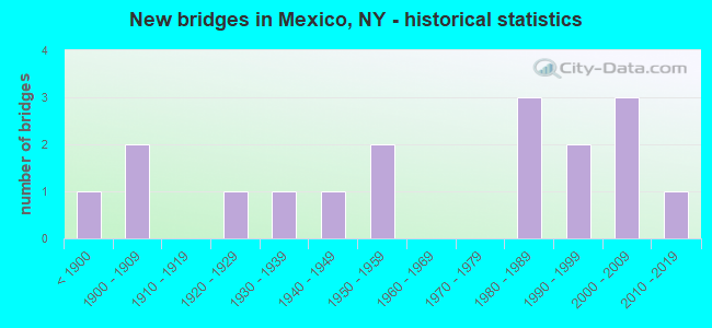
- New bridges - historical statistics
- 1Before 1900
- 21900-1909
- 11920-1929
- 11930-1939
- 11940-1949
- 21950-1959
- 31980-1989
- 21990-1999
- 32000-2009
- 12010-2019

- Reconstructed bridges - Historical Statistics
- 11960-1969
- 01970-1979
- 01980-1989
- 01990-1999
- 32000-2009
- 12010-2019

- Bridge Condition - Deck
- 6.7%Excellent
- 46.7%Good
- 33.3%Satisfactory
- 13.3%Fair

- Bridge Condition - Superstructure
- 6.7%Excellent
- 13.3%Very good
- 40.0%Good
- 20.0%Satisfactory
- 20.0%Fair

- Bridge Condition - Substructure
- 6.7%Excellent
- 20.0%Very good
- 13.3%Good
- 13.3%Satisfactory
- 40.0%Fair
- 6.7%Poor

- Bridge Condition - Channel
- 52.9%Good
- 29.4%Satisfactory
- 17.6%Fair

- Bridge Condition - Culverts
- 50.0%Satisfactory
- 50.0%Fair
Find on map >> Show street view
Structure Number: 100033, Location: .8 MI N JCT SH 3 & SH 104 (Lat: 43.467756, Lng: -76.232536), Route carried "on" structure: State highway 3, Year Built: 2002, Status: Open, Structure Length: 2.32m (7.61ft), Average Daily Traffic: 1,478 (year 2018), Truck Traffic: 7%, Average Future Daily Traffic: 1,487 (year 2040), Design Load: HS 25 or greater, Features Intersected: LITT SALMON RIVER
Minimum Vertical Clearance: 30+ m (98+ ft), Kilometerpoint: 43.990, Lanes on structure: 2, Base Highway Network: Yes, Owner: State Highway Agency, Approaching Roadway Width: 9.8m (32.2ft), Material/Design: Steel, Design/Construction: Stringer/Multi-beam, Number Of Spans In Main Unit: 1, Length of Maximum Span: 23.0m (75.5ft), Curb or Sidewalk Widths: Left: 0.0m, Right: 1.5m (4.9ft), Curb-To-Curb Width: 9.8m (32.2ft), Out-to-Out Width: 12.3m (40.4ft)
Condition: Deck: Good, Superstructure: Very good, Substructure: Very good, Channel: Good, Operating Rating: 78.0 metric tons, Method Used To Determine Operating Rating: Load Factor (LF), Inventory Rating: 47.0 metric tons, Method Used To Determine Inventory Rating: Load Factor (LF), Structural Evaluation: Equal to present desirable criteria, Deck Geometry: Somewhat better than minimum adequacy, Waterway Adequacy: Equal to present minimum criteria, Approach Roadway Alignment: Equal to present desirable criteria, Length Of Structure Improvement: 2.31m (7.58ft), Designated Inspection Frequency: Every 24 months, Inspection Date: September 2020, Bridge Improvement Cost: $652,000, Roadway Improvement Cost: $382,000, Total Project Cost: $1,033,000 ( Estimate for 2021), Deck Structure Type: Concrete Cast-file-Place, Wearing Surface/Protective System: Wearing Surface: Integral Concrete, Deck Protection: Epoxy Coated Reinforcing
Find on map >> Show street view
Structure Number: 100034, Location: 6.2 MI S JCT RTS 3 + 13 (Lat: 43.502950, Lng: -76.232750), Route carried "on" structure: State highway 3, Year Built: 2002, Status: Open, Structure Length: 1.95m (6.40ft), Average Daily Traffic: 1,478 (year 2018), Truck Traffic: 7%, Average Future Daily Traffic: 1,487 (year 2040), Design Load: HS 25 or greater, Features Intersected: SAGE CREEK
Minimum Vertical Clearance: 30+ m (98+ ft), Kilometerpoint: 47.916, Lanes on structure: 2, Base Highway Network: Yes, Owner: State Highway Agency, Approaching Roadway Width: 9.8m (32.2ft), Skew: 1 degrees, Material/Design: Steel, Design/Construction: Stringer/Multi-beam, Number Of Spans In Main Unit: 1, Length of Maximum Span: 18.9m (62.0ft), Curb-To-Curb Width: 9.8m (32.2ft), Out-to-Out Width: 10.8m (35.4ft)
Condition: Deck: Good, Superstructure: Good, Substructure: Very good, Channel: Good, Operating Rating: 32.4 metric tons, Method Used To Determine Operating Rating: Load and Resistance Factor Rating (LRFR) rating reported by rating factor(RF) method using HL-93 loadings, Inventory Rating: 24.9 metric tons, Method Used To Determine Inventory Rating: Load and Resistance Factor Rating (LRFR) rating reported by rating factor(RF) method using HL-93 loadings, Structural Evaluation: Equal to present minimum criteria, Deck Geometry: Somewhat better than minimum adequacy, Waterway Adequacy: Equal to present minimum criteria, Approach Roadway Alignment: Equal to present desirable criteria, Length Of Structure Improvement: 1.95m (6.40ft), Designated Inspection Frequency: Every 24 months, Inspection Date: May 2020, Bridge Improvement Cost: $468,000, Roadway Improvement Cost: $274,000, Total Project Cost: $743,000 ( Estimate for 2021), Deck Structure Type: Concrete Cast-file-Place, Wearing Surface/Protective System: Wearing Surface: Integral Concrete
Find on map >> Show street view
Structure Number: 103662, Location: .2 MI E JCT SH 104 & SH 3 (Lat: 43.459847, Lng: -76.226578), Route carried "on" structure: State highway 104, Year Built: 1992, Status: Open, Structure Length: 2.71m (8.89ft), Average Daily Traffic: 3,027 (year 2018), Truck Traffic: 13%, Average Future Daily Traffic: 3,129 (year 2040), Design Load: HS 20, Features Intersected: LITTLE SALMON RIVER
Minimum Vertical Clearance: 30+ m (98+ ft), Kilometerpoint: 46.709, Lanes on structure: 2, Base Highway Network: Yes, Owner: State Highway Agency, Approaching Roadway Width: 11.6m (38.1ft), Skew: 1 degrees, Material/Design: Steel, Design/Construction: Stringer/Multi-beam, Number Of Spans In Main Unit: 1, Length of Maximum Span: 26.2m (86.0ft), Curb or Sidewalk Widths: Left: 1.5m (4.9ft), Right: 1.5m (4.9ft), Curb-To-Curb Width: 11.6m (38.1ft), Out-to-Out Width: 15.2m (49.9ft)
Condition: Deck: Satisfactory, Superstructure: Good, Substructure: Good, Channel: Satisfactory, Operating Rating: 88.9 metric tons, Method Used To Determine Operating Rating: Load Factor (LF), Inventory Rating: 42.6 metric tons, Method Used To Determine Inventory Rating: Load Factor (LF), Structural Evaluation: Better than present minimum criteria, Deck Geometry: Somewhat better than minimum adequacy, Waterway Adequacy: Somewhat better than minimum adequacy, Approach Roadway Alignment: Equal to present desirable criteria, Length Of Structure Improvement: 2.71m (8.89ft), Designated Inspection Frequency: Every 24 months, Inspection Date: June 2021, Bridge Improvement Cost: $1,068,000, Roadway Improvement Cost: $625,000, Total Project Cost: $1,693,000 ( Estimate for 2021), Deck Structure Type: Concrete Cast-file-Place, Wearing Surface/Protective System: Wearing Surface: Integral Concrete, Deck Protection: Epoxy Coated Reinforcing
Find on map >> Show street view
Structure Number: 103672, Location: 1.2 MI W JCT SH104B & SH3 (Lat: 43.512469, Lng: -76.247581), Route carried "on" structure: State highway 104B, Year Built: 1927, Year Reconstructed: 1974, Status: Open, Structure Length: 3.35m (10.99ft), Average Daily Traffic: 3,046 (year 2020), Truck Traffic: 10%, Average Future Daily Traffic: 4,258 (year 2040), Design Load: HS 20, Features Intersected: LITT SALMON RIVER
Minimum Vertical Clearance: 30+ m (98+ ft), Kilometerpoint: 7.820, Lanes on structure: 2, Base Highway Network: Yes, Owner: State Highway Agency, Approaching Roadway Width: 8.5m (27.9ft), Material/Design: Concrete, Design/Construction: Arch - Deck, Number Of Spans In Main Unit: 1, Length of Maximum Span: 22.5m (73.8ft), Curb-To-Curb Width: 8.5m (27.9ft), Out-to-Out Width: 9.4m (30.8ft)
Condition: Deck: Fair, Superstructure: Fair, Substructure: Fair, Channel: Satisfactory, Operating Rating: 82.2 metric tons, Method Used To Determine Operating Rating: Field evaluation and documented engineering judgment, Inventory Rating: 19.6 metric tons, Method Used To Determine Inventory Rating: Field evaluation and documented engineering judgment, Structural Evaluation: Somewhat better than minimum adequacy, Deck Geometry: Meets minimum limits, Waterway Adequacy: Equal to present minimum criteria, Approach Roadway Alignment: Equal to present desirable criteria, Length Of Structure Improvement: 3.35m (10.99ft), Designated Inspection Frequency: Every 24 months, Inspection Date: November 2021, Bridge Improvement Cost: $1,904,000, Roadway Improvement Cost: $1,115,000, Total Project Cost: $3,018,000 ( Estimate for 2021), Deck Structure Type: Concrete Cast-file-Place, Wearing Surface/Protective System: Wearing Surface: Bituminous
Find on map >> Show street view
Structure Number: 103673, Location: 0.7 MI W JCT RTS 104B + 3 (Lat: 43.513019, Lng: -76.235894), Route carried "on" structure: State highway 104B, Year Built: 1951, Status: Open, Structure Length: 0.91m (2.99ft), Average Daily Traffic: 3,046 (year 2020), Truck Traffic: 10%, Average Future Daily Traffic: 4,258 (year 2040), Design Load: H 20, Features Intersected: SAGE CREEK
Minimum Vertical Clearance: 30+ m (98+ ft), Kilometerpoint: 8.769, Lanes on structure: 2, Base Highway Network: Yes, Owner: State Highway Agency, Approaching Roadway Width: 13.1m (43.0ft), Material/Design: Concrete, Design/Construction: Culvert, Number Of Spans In Main Unit: 1, Length of Maximum Span: 8.5m (27.9ft)
Condition: Channel: Good, Culverts: Satisfactory, Operating Rating: 68.1 metric tons, Method Used To Determine Operating Rating: Field evaluation and documented engineering judgment, Inventory Rating: 29.4 metric tons, Method Used To Determine Inventory Rating: Field evaluation and documented engineering judgment, Structural Evaluation: Equal to present minimum criteria, Waterway Adequacy: Somewhat better than minimum adequacy, Approach Roadway Alignment: Equal to present desirable criteria, Length Of Structure Improvement: 0.91m (2.99ft), Designated Inspection Frequency: Every 24 months, Inspection Date: August 2021, Bridge Improvement Cost: $1,129,000, Roadway Improvement Cost: $661,000, Total Project Cost: $1,790,000 ( Estimate for 2021), Deck Structure Type: Concrete Cast-file-Place
Find on map >> Show street view
Structure Number: 220899, Location: 2.0 MI NE OF MEXICO (Lat: 43.478278, Lng: -76.193022), Route carried "on" structure: Other road , Year Built: 1900, Status: Posted for load, Structure Length: 0.70m (2.30ft), Average Daily Traffic: 78 (year 2020), Truck Traffic: 8%, Average Future Daily Traffic: 109 (year 2040), Features Intersected: SAGE CREEK, Facility Carried by Structure: COLE ROAD
Minimum Vertical Clearance: 30+ m (98+ ft), Kilometerpoint: 0.016, Lanes on structure: 2, Owner: Town or Township Highway Agency, Approaching Roadway Width: 6.7m (22.0ft), Material/Design: Steel, Design/Construction: Stringer/Multi-beam, Number Of Spans In Main Unit: 1, Length of Maximum Span: 6.4m (21.0ft), Curb-To-Curb Width: 6.6m (21.7ft), Out-to-Out Width: 7.1m (23.3ft)
Condition: Deck: Satisfactory, Superstructure: Satisfactory, Substructure: Fair, Channel: Fair, Operating Rating: 19.1 metric tons, Method Used To Determine Operating Rating: Field evaluation and documented engineering judgment, Inventory Rating: 19.1 metric tons, Method Used To Determine Inventory Rating: Field evaluation and documented engineering judgment, Structural Evaluation: Somewhat better than minimum adequacy, Deck Geometry: Somewhat better than minimum adequacy, Waterway Adequacy: Meets minimum limits, Approach Roadway Alignment: Equal to present desirable criteria, Bridge Posting: Required (Relationship of Operating Rating to Maximum Legal Load: > 39.9% below), Length Of Structure Improvement: 0.70m (2.30ft), Designated Inspection Frequency: Every 12 months, Inspection Date: December 2021, Bridge Improvement Cost: $185,000, Roadway Improvement Cost: $108,000, Total Project Cost: $293,000 ( Estimate for 2021), Deck Structure Type: Concrete Cast-file-Place, Wearing Surface/Protective System: Wearing Surface: Bituminous
Find on map >> Show street view
Structure Number: 220906, Location: AT MEXICO (Lat: 43.453978, Lng: -76.229933), Route carried "on" structure: Other road , Year Built: 1897, Status: Open, Structure Length: 0.82m (2.69ft), Average Daily Traffic: 1,340 (year 2017), Truck Traffic: 3%, Average Future Daily Traffic: 1,876 (year 2037), Features Intersected: BLACK CREEK, Facility Carried by Structure: MUNGER HILL ROAD
Minimum Vertical Clearance: 30+ m (98+ ft), Kilometerpoint: 0.000, Lanes on structure: 2, Owner: Town or Township Highway Agency, Approaching Roadway Width: 6.4m (21.0ft), Material/Design: Steel, Design/Construction: Stringer/Multi-beam, Number Of Spans In Main Unit: 1, Length of Maximum Span: 7.6m (24.9ft), Curb-To-Curb Width: 7.6m (24.9ft), Out-to-Out Width: 8.5m (27.9ft)
Condition: Deck: Fair, Superstructure: Fair, Substructure: Poor, Channel: Satisfactory, Operating Rating: 39.0 metric tons, Method Used To Determine Operating Rating: Load Factor (LF), Inventory Rating: 23.6 metric tons, Method Used To Determine Inventory Rating: Load Factor (LF), Structural Evaluation: Meets minimum limits, Deck Geometry: Meets minimum limits, Waterway Adequacy: Meets minimum limits, Approach Roadway Alignment: Equal to present desirable criteria, Length Of Structure Improvement: 0.82m (2.69ft), Designated Inspection Frequency: Every 24 months, Inspection Date: August 2021, Bridge Improvement Cost: $221,000, Roadway Improvement Cost: $129,000, Total Project Cost: $350,000 ( Estimate for 2021), Deck Structure Type: Concrete Cast-file-Place, Wearing Surface/Protective System: Wearing Surface: Bituminous
Find on map >> Show street view
Structure Number: 320898, Location: 2.6 MI E OF MEXICO (Lat: 43.466814, Lng: -76.180047), Route carried "on" structure: Other road , Year Built: 2018, Status: Open, Structure Length: 1.10m (3.61ft), Average Daily Traffic: 282 (year 2019), Truck Traffic: 8%, Average Future Daily Traffic: 395 (year 2039), Design Load: HS 20, Features Intersected: SAGE CREEK, Facility Carried by Structure: TUBBS ROAD
Minimum Vertical Clearance: 30+ m (98+ ft), Kilometerpoint: 3.186, Lanes on structure: 2, Owner: County Highway Agency, Approaching Roadway Width: 6.1m (20.0ft), Skew: 2 degrees, Material/Design: Steel, Design/Construction: Stringer/Multi-beam, Number Of Spans In Main Unit: 1, Length of Maximum Span: 10.7m (35.1ft), Curb-To-Curb Width: 8.1m (26.6ft), Out-to-Out Width: 8.2m (26.9ft)
Condition: Deck: Excellent, Superstructure: Excellent, Substructure: Excellent, Channel: Fair, Operating Rating: 54.4 metric tons, Method Used To Determine Operating Rating: Load Factor (LF), Inventory Rating: 32.7 metric tons, Method Used To Determine Inventory Rating: Load Factor (LF), Structural Evaluation: Superior to present desirable criteria, Deck Geometry: Somewhat better than minimum adequacy, Waterway Adequacy: Equal to present desirable criteria, Approach Roadway Alignment: Equal to present desirable criteria, Length Of Structure Improvement: 1.09m (3.58ft), Designated Inspection Frequency: Every 24 months, Inspection Date: September 2020, Bridge Improvement Cost: $163,000, Roadway Improvement Cost: $96,000, Total Project Cost: $259,000 ( Estimate for 2021), Deck Structure Type: Steel plate, Wearing Surface/Protective System: Wearing Surface: Bituminous
Find on map >> Show street view
Structure Number: 3209, Location: 2.0 MI N OF MEXICO (Lat: 43.492283, Lng: -76.228150), Route carried "on" structure: Other road , Year Built: 1948, Year Reconstructed: 2009, Status: Open, Structure Length: 0.88m (2.89ft), Average Daily Traffic: 158 (year 2016), Truck Traffic: 8%, Average Future Daily Traffic: 221 (year 2036), Features Intersected: SAGE CREEK, Facility Carried by Structure: COUNTRYMAN ROAD
Minimum Vertical Clearance: 30+ m (98+ ft), Kilometerpoint: 0.531, Lanes on structure: 2, Owner: County Highway Agency, Approaching Roadway Width: 6.1m (20.0ft), Material/Design: Steel, Design/Construction: Stringer/Multi-beam, Number Of Spans In Main Unit: 1, Length of Maximum Span: 7.9m (25.9ft), Curb-To-Curb Width: 9.0m (29.5ft), Out-to-Out Width: 9.6m (31.5ft)
Condition: Deck: Good, Superstructure: Good, Substructure: Fair, Channel: Good, Structural Evaluation: Somewhat better than minimum adequacy, Deck Geometry: Equal to present minimum criteria, Waterway Adequacy: Somewhat better than minimum adequacy, Approach Roadway Alignment: Meets minimum limits, Length Of Structure Improvement: 0.88m (2.89ft), Designated Inspection Frequency: Every 24 months, Inspection Date: October 2021, Bridge Improvement Cost: $280,000, Roadway Improvement Cost: $164,000, Total Project Cost: $445,000 ( Estimate for 2021), Deck Structure Type: Corrugated Steel, Wearing Surface/Protective System: Wearing Surface: Bituminous
Find on map >> Show street view
Structure Number: 320901, Location: 1.4 MI N OF MEXICO (Lat: 43.485319, Lng: -76.225233), Route carried "on" structure: Other road , Year Built: 1987, Status: Open, Structure Length: 1.04m (3.41ft), Average Daily Traffic: 149 (year 2020), Truck Traffic: 8%, Average Future Daily Traffic: 209 (year 2040), Features Intersected: SAGE CREEK, Facility Carried by Structure: MINCLER ROAD
Minimum Vertical Clearance: 30+ m (98+ ft), Kilometerpoint: 0.965, Lanes on structure: 2, Owner: County Highway Agency, Approaching Roadway Width: 10.7m (35.1ft), Material/Design: Steel, Design/Construction: Culvert, Number Of Spans In Main Unit: 2, Length of Maximum Span: 4.5m (14.8ft)
Condition: Channel: Fair, Culverts: Fair, Operating Rating: 74.5 metric tons, Method Used To Determine Operating Rating: Field evaluation and documented engineering judgment, Inventory Rating: 19.6 metric tons, Method Used To Determine Inventory Rating: Field evaluation and documented engineering judgment, Structural Evaluation: Somewhat better than minimum adequacy, Waterway Adequacy: Meets minimum limits, Approach Roadway Alignment: Equal to present desirable criteria, Length Of Structure Improvement: 1.03m (3.38ft), Designated Inspection Frequency: Every 24 months, Inspection Date: August 2020, Bridge Improvement Cost: $256,000, Roadway Improvement Cost: $150,000, Total Project Cost: $406,000 ( Estimate for 2021)
Find on map >> Show street view
Structure Number: 320902, Location: 1.5 MI NE OF MEXICO (Lat: 43.482692, Lng: -76.215631), Route carried "on" structure: Other road , Year Built: 1935, Year Reconstructed: 2010, Status: Open, Structure Length: 0.94m (3.08ft), Average Daily Traffic: 151 (year 2018), Truck Traffic: 8%, Average Future Daily Traffic: 211 (year 2038), Features Intersected: SAGE CREEK, Facility Carried by Structure: FORT LEAZIER ROAD
Minimum Vertical Clearance: 30+ m (98+ ft), Kilometerpoint: 0.724, Lanes on structure: 2, Owner: County Highway Agency, Approaching Roadway Width: 5.5m (18.0ft), Skew: 2 degrees, Material/Design: Steel, Design/Construction: Stringer/Multi-beam, Number Of Spans In Main Unit: 1, Length of Maximum Span: 9.1m (29.9ft), Curb-To-Curb Width: 7.8m (25.6ft), Out-to-Out Width: 8.0m (26.2ft)
Condition: Deck: Satisfactory, Superstructure: Good, Substructure: Fair, Channel: Good, Inventory Rating: 99.8 metric tons, Method Used To Determine Inventory Rating: Allowable Stress (AS), Structural Evaluation: Somewhat better than minimum adequacy, Deck Geometry: Somewhat better than minimum adequacy, Waterway Adequacy: Somewhat better than minimum adequacy, Approach Roadway Alignment: Equal to present minimum criteria, Length Of Structure Improvement: 0.94m (3.08ft), Designated Inspection Frequency: Every 24 months, Inspection Date: September 2020, Bridge Improvement Cost: $310,000, Roadway Improvement Cost: $182,000, Total Project Cost: $492,000 ( Estimate for 2021), Deck Structure Type: Other, Wearing Surface/Protective System: Wearing Surface: Bituminous
Find on map >> Show street view
Structure Number: 320904, Location: 3.0 MI N OF MEXICO (Lat: 43.505617, Lng: -76.232783), Route carried "on" structure: Other road , Year Built: 1904, Year Reconstructed: 2012, Status: Open, Structure Length: 0.76m (2.49ft), Average Daily Traffic: 270 (year 2016), Truck Traffic: 8%, Average Future Daily Traffic: 378 (year 2036), Features Intersected: SAGE CREEK, Facility Carried by Structure: KRANZ ROAD
Minimum Vertical Clearance: 30+ m (98+ ft), Kilometerpoint: 0.145, Lanes on structure: 2, Owner: County Highway Agency, Approaching Roadway Width: 7.3m (24.0ft), Material/Design: Steel, Design/Construction: Stringer/Multi-beam, Number Of Spans In Main Unit: 1, Length of Maximum Span: 7.3m (24.0ft), Curb-To-Curb Width: 7.5m (24.6ft), Out-to-Out Width: 7.6m (24.9ft)
Condition: Deck: Good, Superstructure: Satisfactory, Substructure: Satisfactory, Channel: Good, Structural Evaluation: Equal to present minimum criteria, Deck Geometry: Somewhat better than minimum adequacy, Waterway Adequacy: Somewhat better than minimum adequacy, Approach Roadway Alignment: Equal to present minimum criteria, Length Of Structure Improvement: 0.76m (2.49ft), Designated Inspection Frequency: Every 24 months, Inspection Date: August 2020, Bridge Improvement Cost: $290,000, Roadway Improvement Cost: $170,000, Total Project Cost: $459,000 ( Estimate for 2021), Deck Structure Type: Corrugated Steel, Wearing Surface/Protective System: Wearing Surface: Bituminous
Find on map >> Show street view
Structure Number: 320905, Location: 2 MILES NW OF MEXICO (Lat: 43.494283, Lng: -76.249297), Route carried "on" structure: Other road , Year Built: 1954, Year Reconstructed: 2006, Status: Open, Structure Length: 1.83m (6.00ft), Average Daily Traffic: 255 (year 2016), Truck Traffic: 8%, Average Future Daily Traffic: 357 (year 2036), Features Intersected: LITT SALMON RIVER, Facility Carried by Structure: GEORGE ROAD
Minimum Vertical Clearance: 30+ m (98+ ft), Kilometerpoint: 3.154, Lanes on structure: 2, Owner: County Highway Agency, Approaching Roadway Width: 6.1m (20.0ft), Material/Design: Steel, Design/Construction: Stringer/Multi-beam, Number Of Spans In Main Unit: 1, Length of Maximum Span: 17.2m (56.4ft), Curb-To-Curb Width: 7.0m (23.0ft), Out-to-Out Width: 7.4m (24.3ft)
Condition: Deck: Satisfactory, Superstructure: Fair, Substructure: Fair, Channel: Good, Operating Rating: 67.1 metric tons, Method Used To Determine Operating Rating: Allowable Stress (AS), Inventory Rating: 42.6 metric tons, Method Used To Determine Inventory Rating: Allowable Stress (AS), Structural Evaluation: Somewhat better than minimum adequacy, Deck Geometry: Meets minimum limits, Waterway Adequacy: Equal to present minimum criteria, Approach Roadway Alignment: Equal to present minimum criteria, Length Of Structure Improvement: 1.82m (5.97ft), Designated Inspection Frequency: Every 24 months, Inspection Date: August 2020, Bridge Improvement Cost: $408,000, Roadway Improvement Cost: $239,000, Total Project Cost: $647,000 ( Estimate for 2021), Deck Structure Type: Corrugated Steel, Wearing Surface/Protective System: Wearing Surface: Bituminous, Membrane: Other
Find on map >> Show street view
Structure Number: 331383, Location: VILLAGE OF MEXICO (Lat: 43.466750, Lng: -76.237514), Route carried "on" structure: County highway , Year Built: 1989, Status: Open, Structure Length: 1.92m (6.30ft), Average Daily Traffic: 806 (year 2016), Truck Traffic: 4%, Average Future Daily Traffic: 1,128 (year 2036), Design Load: HS 20, Features Intersected: LITTLE SALMON RIV, Facility Carried by Structure: CR 16
Minimum Vertical Clearance: 30+ m (98+ ft), Kilometerpoint: 0.740, Lanes on structure: 2, Owner: County Highway Agency, Approaching Roadway Width: 6.1m (20.0ft), Material/Design: Prestressed concrete, Design/Construction: Box Beam or Girders - Multiple, Number Of Spans In Main Unit: 2, Length of Maximum Span: 9.1m (29.9ft), Curb-To-Curb Width: 7.9m (25.9ft), Out-to-Out Width: 8.6m (28.2ft)
Condition: Deck: Good, Superstructure: Good, Substructure: Satisfactory, Channel: Good, Operating Rating: 59.9 metric tons, Method Used To Determine Operating Rating: Load Factor (LF), Inventory Rating: 34.5 metric tons, Method Used To Determine Inventory Rating: Load Factor (LF), Structural Evaluation: Equal to present minimum criteria, Deck Geometry: Somewhat better than minimum adequacy, Waterway Adequacy: Somewhat better than minimum adequacy, Approach Roadway Alignment: Equal to present desirable criteria, Length Of Structure Improvement: 1.92m (6.30ft), Designated Inspection Frequency: Every 24 months, Inspection Date: August 2020, Bridge Improvement Cost: $646,000, Roadway Improvement Cost: $378,000, Total Project Cost: $1,024,000 ( Estimate for 2021), Wearing Surface/Protective System: Wearing Surface: Bituminous, Membrane: Epoxy
Find on map >> Show street view
Structure Number: 331384, Location: 2.8 MI NE OF PHOENIX (Lat: 43.511642, Lng: -76.252694), Route carried "on" structure: County highway , Year Built: 1998, Status: Open, Structure Length: 2.56m (8.40ft), Average Daily Traffic: 574 (year 2016), Truck Traffic: 6%, Average Future Daily Traffic: 804 (year 2036), Design Load: HS 25 or greater, Features Intersected: LITTLE SALMON RIV, Facility Carried by Structure: TEXAS RD
Minimum Vertical Clearance: 30+ m (98+ ft), Kilometerpoint: 6.195, Lanes on structure: 2, Owner: County Highway Agency, Approaching Roadway Width: 9.1m (29.9ft), Skew: 1 degrees, Material/Design: Steel, Design/Construction: Stringer/Multi-beam, Number Of Spans In Main Unit: 1, Length of Maximum Span: 24.3m (79.7ft), Curb-To-Curb Width: 9.1m (29.9ft), Out-to-Out Width: 9.8m (32.2ft)
Condition: Deck: Good, Superstructure: Very good, Substructure: Very good, Channel: Good, Operating Rating: 46.0 metric tons, Method Used To Determine Operating Rating: Load and Resistance Factor Rating (LRFR) rating reported by rating factor(RF) method using HL-93 loadings, Inventory Rating: 35.6 metric tons, Method Used To Determine Inventory Rating: Load and Resistance Factor Rating (LRFR) rating reported by rating factor(RF) method using HL-93 loadings, Structural Evaluation: Equal to present desirable criteria, Deck Geometry: Equal to present minimum criteria, Waterway Adequacy: Equal to present desirable criteria, Approach Roadway Alignment: Equal to present desirable criteria, Length Of Structure Improvement: 2.56m (8.40ft), Designated Inspection Frequency: Every 24 months, Inspection Date: March 2020, Bridge Improvement Cost: $768,000, Roadway Improvement Cost: $450,000, Total Project Cost: $1,218,000 ( Estimate for 2021), Deck Structure Type: Concrete Cast-file-Place, Wearing Surface/Protective System: Wearing Surface: Integral Concrete, Deck Protection: Epoxy Coated Reinforcing
Find on map >> Show street view
Structure Number: 331385, Location: 2.5 MI NE OF MEXICO (Lat: 43.479031, Lng: -76.191981), Route carried "on" structure: County highway , Year Built: 1989, Status: Open, Structure Length: 1.28m (4.20ft), Average Daily Traffic: 597 (year 2016), Truck Traffic: 6%, Average Future Daily Traffic: 836 (year 2036), Design Load: HS 20, Features Intersected: SAGE CREEK, Facility Carried by Structure: CR41 Mexico Rd
Minimum Vertical Clearance: 30+ m (98+ ft), Kilometerpoint: 4.586, Lanes on structure: 2, Owner: County Highway Agency, Approaching Roadway Width: 10.4m (34.1ft), Material/Design: Prestressed concrete, Design/Construction: Box Beam or Girders - Multiple, Number Of Spans In Main Unit: 1, Length of Maximum Span: 12.1m (39.7ft), Curb-To-Curb Width: 10.5m (34.4ft), Out-to-Out Width: 11.1m (36.4ft)
Condition: Deck: Good, Superstructure: Good, Substructure: Good, Channel: Satisfactory, Operating Rating: 59.0 metric tons, Method Used To Determine Operating Rating: Load Factor (LF), Inventory Rating: 34.5 metric tons, Method Used To Determine Inventory Rating: Load Factor (LF), Structural Evaluation: Better than present minimum criteria, Deck Geometry: Equal to present minimum criteria, Waterway Adequacy: Equal to present desirable criteria, Approach Roadway Alignment: Equal to present desirable criteria, Length Of Structure Improvement: 1.28m (4.20ft), Designated Inspection Frequency: Every 24 months, Inspection Date: May 2020, Bridge Improvement Cost: $758,000, Roadway Improvement Cost: $444,000, Total Project Cost: $1,202,000 ( Estimate for 2021), Wearing Surface/Protective System: Wearing Surface: Bituminous, Membrane: Epoxy
Find on map >> Show street view
Structure Number: 336584, Location: IN MEXICO (Lat: 43.470039, Lng: -76.245558), Route carried "on" structure: Other road , Year Built: 2008, Status: Open, Structure Length: 1.83m (6.00ft), Average Daily Traffic: 145 (year 2018), Truck Traffic: 8%, Average Future Daily Traffic: 203 (year 2038), Features Intersected: LITTLE SALMON RIVER, Facility Carried by Structure: RIVER STREET
Minimum Vertical Clearance: 30+ m (98+ ft), Kilometerpoint: 0.644, Lanes on structure: 2, Owner: County Highway Agency, Approaching Roadway Width: 7.0m (23.0ft), Material/Design: Steel, Design/Construction: Stringer/Multi-beam, Number Of Spans In Main Unit: 1, Length of Maximum Span: 16.7m (54.8ft), Curb-To-Curb Width: 7.1m (23.3ft), Out-to-Out Width: 7.4m (24.3ft)
Condition: Deck: Satisfactory, Superstructure: Satisfactory, Substructure: Fair, Channel: Satisfactory, Operating Rating: 85.3 metric tons, Method Used To Determine Operating Rating: Allowable Stress (AS), Inventory Rating: 57.2 metric tons, Method Used To Determine Inventory Rating: Allowable Stress (AS), Structural Evaluation: Somewhat better than minimum adequacy, Deck Geometry: Meets minimum limits, Waterway Adequacy: Somewhat better than minimum adequacy, Approach Roadway Alignment: Equal to present desirable criteria, Length Of Structure Improvement: 1.82m (5.97ft), Designated Inspection Frequency: Every 24 months, Inspection Date: May 2021, Bridge Improvement Cost: $367,000, Roadway Improvement Cost: $215,000, Total Project Cost: $583,000 ( Estimate for 2021), Deck Structure Type: Corrugated Steel, Wearing Surface/Protective System: Wearing Surface: Bituminous