Bridge Statistics for Middleburg, Florida (FL)
Condition, Traffic, Stress, Structural Evaluation, Project Costs
- National Bridge Inventory (NBI) Statistics
- 15Number of bridges
- 148ft / 45.5mTotal length
- 179,936Total average daily traffic
- 9,575Total average daily truck traffic
- National Bridge Inventory (NBI) Registered Bridges for Middleburg
- No street view available for this location
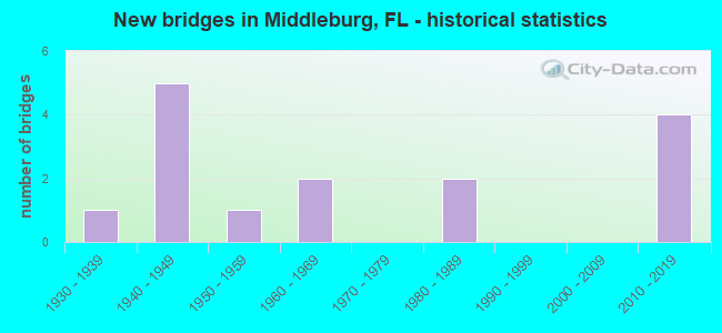
- New bridges - historical statistics
- 11930-1939
- 51940-1949
- 11950-1959
- 21960-1969
- 21980-1989
- 42010-2019
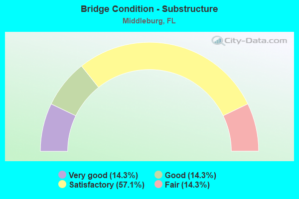
- Bridge Condition - Substructure
- 14.3%Very good
- 14.3%Good
- 57.1%Satisfactory
- 14.3%Fair
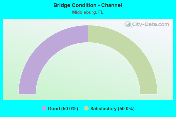
- Bridge Condition - Channel
- 50.0%Good
- 50.0%Satisfactory
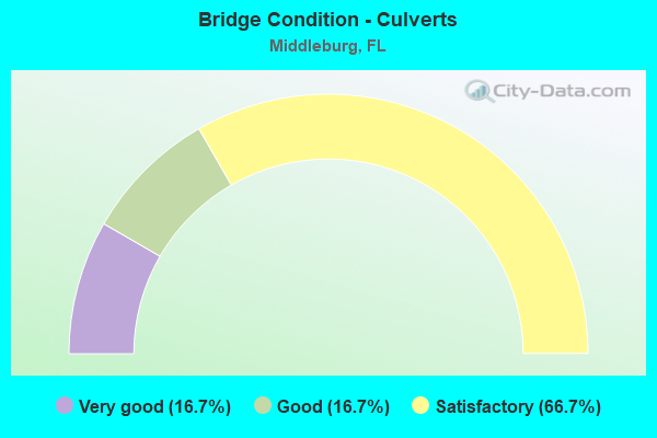
- Bridge Condition - Culverts
- 16.7%Very good
- 16.7%Good
- 66.7%Satisfactory
Find on map >> Show street view
Structure Number: 710017, Location: 0.6 MI. E. OF SR-215 (Lat: 29.981603, Lng: -81.967214), Route carried "on" structure: State highway 16, Year Built: 1942, Status: Open, Structure Length: 5.49m (18.01ft), Average Daily Traffic: 2,150 (year 2020), Truck Traffic: 7%, Average Future Daily Traffic: 3,730 (year 2042), Design Load: H 20, Features Intersected: N. FORK OF BLACK CREEK
Minimum Vertical Clearance: 30+ m (98+ ft), Kilometerpoint: 9.815, Lanes on structure: 2, Base Highway Network: Yes, Owner: State Highway Agency, Approaching Roadway Width: 9.2m (30.2ft), Material/Design: Concrete, Design/Construction: Slab, Number Of Spans In Main Unit: 12, Length of Maximum Span: 4.6m (15.1ft), Curb-To-Curb Width: 8.4m (27.6ft), Out-to-Out Width: 9.5m (31.2ft)
Condition: Deck: Good, Superstructure: Good, Substructure: Satisfactory, Channel: Good, Operating Rating: 51.7 metric tons, Method Used To Determine Operating Rating: Load Factor (LF), Inventory Rating: 30.8 metric tons, Method Used To Determine Inventory Rating: Load Factor (LF), Structural Evaluation: Equal to present minimum criteria, Deck Geometry: High priority of corrective action, Waterway Adequacy: Equal to present desirable criteria, Approach Roadway Alignment: Equal to present desirable criteria, Designated Inspection Frequency: Every 24 months, Inspection Date: May 2020, Deck Structure Type: Concrete Cast-file-Place, Wearing Surface/Protective System: Wearing Surface: Bituminous
Find on map >> Show street view
Structure Number: 710019, Location: 1.2 MI EAST OF SR 21 (Lat: 30.092500, Lng: -81.838889), Route carried "on" structure: County highway 220, Year Built: 1959, Status: Open, Structure Length: 0.63m (2.07ft), Average Daily Traffic: 9,200 (year 2020), Truck Traffic: 2%, Average Future Daily Traffic: 15,962 (year 2042), Features Intersected: GROG BRANCH
Minimum Vertical Clearance: 30+ m (98+ ft), Kilometerpoint: 3.846, Lanes on structure: 2, Owner: County Highway Agency, Approaching Roadway Width: 6.7m (22.0ft), Material/Design: Concrete, Design/Construction: Culvert, Number Of Spans In Main Unit: 2, Length of Maximum Span: 3.1m (10.2ft)
Condition: Channel: Satisfactory, Culverts: Satisfactory, Operating Rating: 83.0 metric tons, Method Used To Determine Operating Rating: Load Factor (LF), Inventory Rating: 49.8 metric tons, Method Used To Determine Inventory Rating: Load Factor (LF), Structural Evaluation: Equal to present minimum criteria, Waterway Adequacy: Equal to present desirable criteria, Approach Roadway Alignment: Equal to present desirable criteria, Designated Inspection Frequency: Every 24 months, Underwater Inspection Frequency: Every 24 months, Inspection Date: September 2020, Underwater Inspection Date: September 2020
Find on map >> Show street view
Structure Number: 71002, Location: 0.81MI WEST OF SR 21 (Lat: 30.070500, Lng: -81.879444), Route carried "on" structure: County highway 220, Year Built: 1960, Status: Open, Structure Length: 0.69m (2.26ft), Average Daily Traffic: 299 (year 2020), Truck Traffic: 10%, Average Future Daily Traffic: 519 (year 2042), Features Intersected: DILLABERRY BRANCH, Facility Carried by Structure: EVERETT AVENUE
Minimum Vertical Clearance: 30+ m (98+ ft), Kilometerpoint: 1.411, Lanes on structure: 2, Owner: County Highway Agency, Approaching Roadway Width: 6.1m (20.0ft), Skew: 2 degrees, Material/Design: Concrete, Design/Construction: Culvert, Number Of Spans In Main Unit: 2, Length of Maximum Span: 3.6m (11.8ft)
Condition: Channel: Satisfactory, Culverts: Satisfactory, Operating Rating: 49.4 metric tons, Method Used To Determine Operating Rating: Load and Resistance Factor (LRFR), Inventory Rating: 31.7 metric tons, Method Used To Determine Inventory Rating: Load and Resistance Factor (LRFR), Structural Evaluation: Equal to present minimum criteria, Waterway Adequacy: Equal to present minimum criteria, Approach Roadway Alignment: Equal to present desirable criteria, Designated Inspection Frequency: Every 24 months, Inspection Date: September 2020
Find on map >> Show street view
Structure Number: 710033, Location: 0.6 MI. E. OF SR-215 (Lat: 29.981472, Lng: -81.967217), Route carried "on" structure: State highway 16, Year Built: 1942, Status: Open, Structure Length: 5.49m (18.01ft), Average Daily Traffic: 2,150 (year 2020), Truck Traffic: 7%, Average Future Daily Traffic: 3,730 (year 2042), Design Load: H 20, Features Intersected: N. FORK OF BLACK CREEK
Minimum Vertical Clearance: 30+ m (98+ ft), Kilometerpoint: 9.815, Lanes on structure: 2, Base Highway Network: Yes, Owner: State Highway Agency, Approaching Roadway Width: 9.2m (30.2ft), Material/Design: Concrete, Design/Construction: Slab, Number Of Spans In Main Unit: 12, Length of Maximum Span: 4.6m (15.1ft), Curb-To-Curb Width: 8.4m (27.6ft), Out-to-Out Width: 9.5m (31.2ft)
Condition: Deck: Good, Superstructure: Good, Substructure: Satisfactory, Channel: Good, Operating Rating: 51.7 metric tons, Method Used To Determine Operating Rating: Load Factor (LF), Inventory Rating: 30.8 metric tons, Method Used To Determine Inventory Rating: Load Factor (LF), Structural Evaluation: Equal to present minimum criteria, Deck Geometry: High priority of corrective action, Waterway Adequacy: Equal to present desirable criteria, Approach Roadway Alignment: Equal to present desirable criteria, Designated Inspection Frequency: Every 24 months, Inspection Date: May 2020, Deck Structure Type: Concrete Cast-file-Place, Wearing Surface/Protective System: Wearing Surface: Bituminous
Find on map >> Show street view
Structure Number: 710036, Location: 0.7 MI. S. OF SR-16 (Lat: 29.968433, Lng: -81.897711), Route carried "on" structure: State highway 21, Year Built: 1934, Status: Open, Structure Length: 0.64m (2.10ft), Average Daily Traffic: 8,500 (year 2020), Truck Traffic: 8%, Average Future Daily Traffic: 14,748 (year 2042), Design Load: H 15, Features Intersected: CLEAR CUT CREEK
Minimum Vertical Clearance: 30+ m (98+ ft), Kilometerpoint: 35.628, Lanes on structure: 2, Base Highway Network: Yes, Owner: State Highway Agency, Approaching Roadway Width: 10.5m (34.4ft), Material/Design: Concrete, Design/Construction: Culvert, Number Of Spans In Main Unit: 2, Length of Maximum Span: 3.0m (9.8ft)
Condition: Channel: Satisfactory, Culverts: Satisfactory, Operating Rating: 70.5 metric tons, Method Used To Determine Operating Rating: Load Factor (LF), Inventory Rating: 42.2 metric tons, Method Used To Determine Inventory Rating: Load Factor (LF), Structural Evaluation: Equal to present minimum criteria, Waterway Adequacy: Equal to present desirable criteria, Approach Roadway Alignment: Equal to present desirable criteria, Designated Inspection Frequency: Every 24 months, Inspection Date: October 2020
Find on map >> Show street view
Structure Number: 710052, Location: 0.5 MI NORTHEAST OF SR 16 (Lat: 29.983972, Lng: -81.967806), Route carried "on" structure: County highway 215, Year Built: 1942, Status: Open, Structure Length: 5.49m (18.01ft), Average Daily Traffic: 6,000 (year 2020), Truck Traffic: 1%, Average Future Daily Traffic: 10,410 (year 2042), Features Intersected: NORTH FORK BLACK CREEK
Minimum Vertical Clearance: 30+ m (98+ ft), Kilometerpoint: 0.695, Lanes on structure: 2, Owner: County Highway Agency, Approaching Roadway Width: 7.1m (23.3ft), Material/Design: Concrete, Design/Construction: Slab, Number Of Spans In Main Unit: 12, Length of Maximum Span: 4.6m (15.1ft), Curb or Sidewalk Widths: Left: 0.5m (1.6ft), Right: 0.5m (1.6ft), Curb-To-Curb Width: 8.5m (27.9ft), Out-to-Out Width: 9.4m (30.8ft)
Condition: Deck: Good, Superstructure: Good, Substructure: Satisfactory, Channel: Good, Operating Rating: 44.1 metric tons, Method Used To Determine Operating Rating: Load and Resistance Factor (LRFR), Inventory Rating: 33.9 metric tons, Method Used To Determine Inventory Rating: Load and Resistance Factor (LRFR), Structural Evaluation: Equal to present minimum criteria, Deck Geometry: High priority of replacement, Waterway Adequacy: Equal to present desirable criteria, Approach Roadway Alignment: Better than present minimum criteria, Designated Inspection Frequency: Every 24 months, Inspection Date: September 2020, Deck Structure Type: Concrete Cast-file-Place, Wearing Surface/Protective System: Wearing Surface: Bituminous
Find on map >> Show street view
Structure Number: 710053, Location: 4.4 MI NORTHEAST OF SR 16 (Lat: 30.021222, Lng: -81.919722), Route carried "on" structure: County highway 215, Year Built: 1942, Status: Open, Structure Length: 4.57m (14.99ft), Average Daily Traffic: 6,000 (year 2020), Truck Traffic: 1%, Average Future Daily Traffic: 10,410 (year 2042), Features Intersected: BULL CREEK
Minimum Vertical Clearance: 30+ m (98+ ft), Kilometerpoint: 6.928, Lanes on structure: 2, Owner: County Highway Agency, Approaching Roadway Width: 6.9m (22.6ft), Material/Design: Concrete, Design/Construction: Slab, Number Of Spans In Main Unit: 10, Length of Maximum Span: 4.6m (15.1ft), Curb or Sidewalk Widths: Left: 0.5m (1.6ft), Right: 0.5m (1.6ft), Curb-To-Curb Width: 8.5m (27.9ft), Out-to-Out Width: 9.4m (30.8ft)
Condition: Deck: Good, Superstructure: Good, Substructure: Satisfactory, Channel: Good, Operating Rating: 44.1 metric tons, Method Used To Determine Operating Rating: Load and Resistance Factor (LRFR), Inventory Rating: 33.9 metric tons, Method Used To Determine Inventory Rating: Load and Resistance Factor (LRFR), Structural Evaluation: Equal to present minimum criteria, Deck Geometry: High priority of replacement, Waterway Adequacy: Equal to present desirable criteria, Approach Roadway Alignment: Equal to present desirable criteria, Designated Inspection Frequency: Every 24 months, Underwater Inspection Frequency: Every 24 months, Inspection Date: September 2020, Underwater Inspection Date: September 2020, Deck Structure Type: Concrete Cast-file-Place, Wearing Surface/Protective System: Wearing Surface: Bituminous
Find on map >> Show street view
Structure Number: 710054, Location: 0.5 MI SOUTHWEST OF SR 21 (Lat: 30.034583, Lng: -81.902500), Route carried "on" structure: County highway 215, Year Built: 1942, Status: Open, Structure Length: 5.94m (19.49ft), Average Daily Traffic: 6,000 (year 2020), Truck Traffic: 1%, Average Future Daily Traffic: 10,410 (year 2042), Features Intersected: BULL CREEK
Minimum Vertical Clearance: 30+ m (98+ ft), Kilometerpoint: 9.152, Lanes on structure: 2, Owner: County Highway Agency, Approaching Roadway Width: 6.9m (22.6ft), Material/Design: Concrete, Design/Construction: Slab, Number Of Spans In Main Unit: 13, Length of Maximum Span: 4.6m (15.1ft), Curb or Sidewalk Widths: Left: 0.5m (1.6ft), Right: 0.5m (1.6ft), Curb-To-Curb Width: 8.5m (27.9ft), Out-to-Out Width: 9.4m (30.8ft)
Condition: Deck: Good, Superstructure: Good, Substructure: Fair, Channel: Good, Operating Rating: 44.1 metric tons, Method Used To Determine Operating Rating: Load and Resistance Factor (LRFR), Inventory Rating: 33.9 metric tons, Method Used To Determine Inventory Rating: Load and Resistance Factor (LRFR), Structural Evaluation: Somewhat better than minimum adequacy, Deck Geometry: High priority of replacement, Waterway Adequacy: Better than present minimum criteria, Approach Roadway Alignment: Equal to present desirable criteria, Designated Inspection Frequency: Every 24 months, Underwater Inspection Frequency: Every 24 months, Inspection Date: September 2020, Underwater Inspection Date: September 2020, Deck Structure Type: Concrete Cast-file-Place, Wearing Surface/Protective System: Wearing Surface: Bituminous
Find on map >> Show street view
Structure Number: 71006, Location: SR-21 & CR-220 (Lat: 30.087222, Lng: -81.856944), Route carried "on" structure: State highway 21, Year Built: 1986, Status: Open, Structure Length: 0.64m (2.10ft), Average Daily Traffic: 36,500 (year 2020), Truck Traffic: 4%, Average Future Daily Traffic: 63,328 (year 2042), Design Load: HS 20+Mod, Features Intersected: GROG BRANCH
Minimum Vertical Clearance: 30+ m (98+ ft), Kilometerpoint: 6.251, Lanes on structure: 7, Base Highway Network: Yes, Owner: State Highway Agency, Approaching Roadway Width: 23.2m (76.1ft), Skew: 14 degrees, Material/Design: Concrete, Design/Construction: Culvert, Number Of Spans In Main Unit: 2, Length of Maximum Span: 3.0m (9.8ft)
Condition: Channel: Satisfactory, Culverts: Good, Structural Evaluation: Better than present minimum criteria, Waterway Adequacy: Equal to present minimum criteria, Approach Roadway Alignment: Equal to present desirable criteria, Designated Inspection Frequency: Every 24 months, Inspection Date: March 2020
Find on map >> Show street view
Structure Number: 710062, Location: 0.5 MI. N. OF CR-215 (Lat: 30.044742, Lng: -81.892883), Route carried "on" structure: State highway 21, Year Built: 1988, Status: Open, Structure Length: 0.64m (2.10ft), Average Daily Traffic: 17,036 (year 2020), Truck Traffic: 7%, Average Future Daily Traffic: 29,557 (year 2042), Design Load: HS 20+Mod, Features Intersected: MILL CREEK
Minimum Vertical Clearance: 30+ m (98+ ft), Kilometerpoint: 0.285, Lanes on structure: 4, Base Highway Network: Yes, Owner: State Highway Agency, Approaching Roadway Width: 18.3m (60.0ft), Skew: 10 degrees, Material/Design: Concrete, Design/Construction: Culvert, Number Of Spans In Main Unit: 2, Length of Maximum Span: 3.0m (9.8ft)
Condition: Channel: Satisfactory, Culverts: Satisfactory, Operating Rating: 63.5 metric tons, Method Used To Determine Operating Rating: Load Factor (LF), Inventory Rating: 38.1 metric tons, Method Used To Determine Inventory Rating: Load Factor (LF), Structural Evaluation: Equal to present minimum criteria, Waterway Adequacy: Equal to present desirable criteria, Approach Roadway Alignment: Equal to present desirable criteria, Designated Inspection Frequency: Every 24 months, Inspection Date: March 2020
Find on map >> Show street view
Structure Number: 710103, Location: 1.08 MI S OF OLD JENNG RD (Lat: 30.099400, Lng: -81.836728), Route carried "on" structure: Ramp State highway 23, Year Built: 2017, Status: Open, Structure Length: 9.42m (30.91ft), Average Daily Traffic: 17,500 (year 2016), Truck Traffic: 8%, Average Future Daily Traffic: 30,363 (year 2038), Design Load: HL 93, Features Intersected: BLANDING BLVD
Minimum Vertical Clearance: 30+ m (98+ ft), Kilometerpoint: 0.813, Lanes on structure: 1, Lanes under structure: 5, Toll: On toll road, Owner: State Toll Authority, Approaching Roadway Width: 9.1m (29.9ft), Skew: 4 degrees, Material/Design: Prestressed concrete, Design/Construction: Stringer/Multi-beam, Number Of Spans In Main Unit: 2, Length of Maximum Span: 47.6m (156.2ft), Curb-To-Curb Width: 8.2m (26.9ft), Out-to-Out Width: 9.2m (30.2ft)
Condition: Deck: Good, Superstructure: Good, Substructure: Very good, Operating Rating: 74.1 metric tons, Method Used To Determine Operating Rating: Load and Resistance Factor (LRFR), Inventory Rating: 53.9 metric tons, Method Used To Determine Inventory Rating: Load and Resistance Factor (LRFR), Structural Evaluation: Better than present minimum criteria, Deck Geometry: Superior to present desirable criteria, Underclear: Superior to present desirable criteria, Approach Roadway Alignment: Equal to present desirable criteria, Designated Inspection Frequency: Every 24 months, Inspection Date: March 2020, Deck Structure Type: Concrete Cast-file-Place
Find on map >> Show street view
Structure Number: 710941, Location: 0.4 MI. S. OF CR-215 (Lat: 30.030469, Lng: -81.897592), Route carried "on" structure: State highway 21, Year Built: 1969, Status: Open, Structure Length: 4.57m (14.99ft), Average Daily Traffic: 6,500 (year 2020), Truck Traffic: 8%, Average Future Daily Traffic: 11,278 (year 2042), Design Load: HS 20, Features Intersected: BULL CREEK
Minimum Vertical Clearance: 30+ m (98+ ft), Kilometerpoint: 42.495, Lanes on structure: 2, Base Highway Network: Yes, Owner: State Highway Agency, Approaching Roadway Width: 9.8m (32.2ft), Material/Design: Prestressed concrete, Design/Construction: Stringer/Multi-beam, Number Of Spans In Main Unit: 3, Length of Maximum Span: 15.2m (49.9ft), Curb-To-Curb Width: 13.4m (44.0ft), Out-to-Out Width: 14.1m (46.3ft)
Condition: Deck: Good, Superstructure: Good, Substructure: Good, Channel: Satisfactory, Operating Rating: 44.5 metric tons, Method Used To Determine Operating Rating: Load and Resistance Factor (LRFR), Inventory Rating: 27.5 metric tons, Method Used To Determine Inventory Rating: Load and Resistance Factor (LRFR), Structural Evaluation: Equal to present minimum criteria, Deck Geometry: Equal to present minimum criteria, Waterway Adequacy: Equal to present desirable criteria, Approach Roadway Alignment: Equal to present desirable criteria, Designated Inspection Frequency: Every 24 months, Inspection Date: August 2020, Deck Structure Type: Concrete Cast-file-Place
Find on map >> Show street view
Structure Number: 714067, Location: 0.3 MI N of SR-21 (Lat: 30.099533, Lng: -81.842328), Route carried "on" structure: County highway , Year Built: 2018, Status: Open, Structure Length: 1.28m (4.20ft), Average Daily Traffic: 101 (year 2020), Truck Traffic: 5%, Average Future Daily Traffic: 126 (year 2042), Design Load: HL 93, Features Intersected: Grog Branch, Facility Carried by Structure: CE Access Rd.
Minimum Vertical Clearance: 30.18m (99.02ft), Kilometerpoint: 6.116, Lanes on structure: 2, Owner: County Highway Agency, Approaching Roadway Width: 10.4m (34.1ft), Material/Design: Concrete, Design/Construction: Culvert, Number Of Spans In Main Unit: 4, Length of Maximum Span: 2.7m (8.9ft)
Condition: Channel: Good, Culverts: Very good, Operating Rating: 73.8 metric tons, Method Used To Determine Operating Rating: Load and Resistance Factor (LRFR), Inventory Rating: 57.2 metric tons, Method Used To Determine Inventory Rating: Load and Resistance Factor (LRFR), Structural Evaluation: Equal to present desirable criteria, Waterway Adequacy: Better than present minimum criteria, Approach Roadway Alignment: Better than present minimum criteria, Designated Inspection Frequency: Every 24 months, Underwater Inspection Frequency: Every 24 months, Inspection Date: July 2020, Underwater Inspection Date: July 2020
Find on map >> Show street view
Structure Number: 710103, Location: 1.08 MI S OF OLD JENNG RD (Lat: 30.099400, Lng: -81.836728), Route carried "under" structure: State highway 21, Year Built: 2017, Structure Length: 0. m, Average Daily Traffic: 44,500 (year 2018), Truck Traffic: 5%, Features Intersected: BLANDING BLVD, Facility Carried by Structure: SR 23 ON-RAMP 0.5
Minimum Vertical Clearance: 5.21m (17.09ft), Kilometerpoint: 8.668, Lanes on structure: 1, Lanes under structure: 4, Material/Design: Prestressed concrete, Design/Construction: Stringer/Multi-beam, Length of Maximum Span: 47.6m (156.2ft)
Find on map >> Show street view
Structure Number: 710103, Location: 1.08 MI S OF OLD JENNG RD (Lat: 30.099400, Lng: -81.836728), Route carried "under" structure: Ramp State highway 23, Year Built: 2017, Structure Length: 0. m, Average Daily Traffic: 17,500 (year 2016), Truck Traffic: 8%, Features Intersected: BLANDING BLVD
Minimum Vertical Clearance: 5.55m (18.21ft), Kilometerpoint: 0.370, Lanes on structure: 1, Lanes under structure: 1, Toll: On toll road, Material/Design: Prestressed concrete, Design/Construction: Stringer/Multi-beam, Length of Maximum Span: 47.6m (156.2ft)