Bridge Statistics for Mildred, Kansas (KS)
Condition, Traffic, Stress, Structural Evaluation, Project Costs
- National Bridge Inventory (NBI) Statistics
- 10Number of bridges
- 79ft / 23.6mTotal length
- $1,169,000Total costs
- 2,671Total average daily traffic
- 468Total average daily truck traffic
- 3,150Total future (year 2040) average daily traffic
- National Bridge Inventory (NBI) Registered Bridges for Mildred
- No street view available for this location
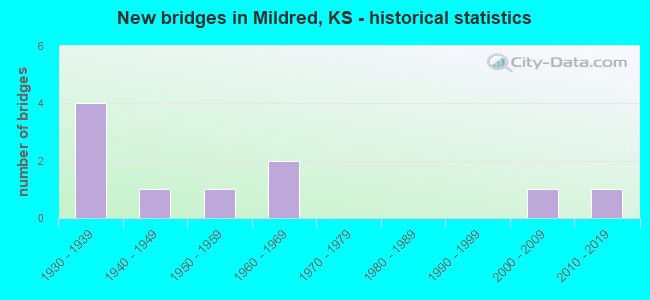
- New bridges - historical statistics
- 41930-1939
- 11940-1949
- 11950-1959
- 21960-1969
- 12000-2009
- 12010-2019

- Bridge Condition - Deck
- 22.2%Very good
- 55.6%Good
- 22.2%Satisfactory

- Bridge Condition - Superstructure
- 33.3%Very good
- 44.4%Good
- 22.2%Satisfactory

- Bridge Condition - Substructure
- 44.4%Very good
- 22.2%Good
- 11.1%Satisfactory
- 11.1%Fair
- 11.1%Poor

- Bridge Condition - Channel
- 20.0%Very good
- 40.0%Good
- 10.0%Satisfactory
- 20.0%Fair
- 10.0%Poor
Find on map >> Show street view
Structure Number: 1019, Location: 0.2W OF MILDRED (Lat: 38.023219, Lng: -95.185600), Route carried "on" structure: County highway 4, Year Built: 1948, Status: Posted for load, Structure Length: 1.32m (4.33ft), Average Daily Traffic: 230 (year 2006), Truck Traffic: 10%, Average Future Daily Traffic: 232 (year 2040), Design Load: H 10, Features Intersected: BRANCH OF MIDDLE CREEK
Minimum Vertical Clearance: 30.47m (99.97ft), Kilometerpoint: 34.127, Lanes on structure: 2, Owner: County Highway Agency, Approaching Roadway Width: 6.0m (19.7ft), Material/Design: Concrete, Design/Construction: Culvert, Number Of Spans In Main Unit: 3, Length of Maximum Span: 4.3m (14.1ft), Curb-To-Curb Width: 7.9m (25.9ft), Out-to-Out Width: 8.7m (28.5ft)
Condition: Channel: Good, Culverts: Good, Operating Rating: 36.9 metric tons, Method Used To Determine Operating Rating: Load Factor (LF), Inventory Rating: 21.6 metric tons, Method Used To Determine Inventory Rating: Load Factor (LF), Structural Evaluation: Equal to present minimum criteria, Deck Geometry: Somewhat better than minimum adequacy, Waterway Adequacy: Better than present minimum criteria, Approach Roadway Alignment: Equal to present desirable criteria, Designated Inspection Frequency: Every 24 months, Inspection Date: March 2020, Other Special Inspection Date: August 2021
Find on map >> Show street view
Structure Number: 11051005744, Location: 1.5S 2.0W OF MILDRED (Lat: 38.002261, Lng: -95.207161), Route carried "on" structure: County highway , Year Built: 1930, Status: Open, Structure Length: 0.73m (2.40ft), Average Daily Traffic: 60 (year 2006), Average Future Daily Traffic: 60 (year 2040), Features Intersected: STREAM, Facility Carried by Structure: 3600 St. 18.0-C.4
Minimum Vertical Clearance: 30.47m (99.97ft), Kilometerpoint: 0.000, Lanes on structure: 2, Owner: County Highway Agency, Approaching Roadway Width: 6.7m (22.0ft), Material/Design: Concrete, Design/Construction: Slab, Number Of Spans In Main Unit: 2, Length of Maximum Span: 3.0m (9.8ft), Curb-To-Curb Width: 7.3m (24.0ft), Out-to-Out Width: 7.9m (25.9ft)
Condition: Deck: Good, Superstructure: Satisfactory, Substructure: Fair, Channel: Satisfactory, Operating Rating: 27.0 metric tons, Method Used To Determine Operating Rating: Load Testing, Inventory Rating: 19.8 metric tons, Method Used To Determine Inventory Rating: Load Testing, Structural Evaluation: Somewhat better than minimum adequacy, Deck Geometry: Equal to present minimum criteria, Waterway Adequacy: Somewhat better than minimum adequacy, Approach Roadway Alignment: Better than present minimum criteria, Length Of Structure Improvement: 0.76m (2.49ft), Designated Inspection Frequency: Every 24 months, Inspection Date: March 2020, Bridge Improvement Cost: $44,000, Roadway Improvement Cost: $20,000, Total Project Cost: $66,000, Deck Structure Type: Concrete Cast-file-Place, Wearing Surface/Protective System: Wearing Surface: Gravel
Find on map >> Show street view
Structure Number: 1105120574, Location: 1.0S 1.5W OF MILDRED (Lat: 38.008700, Lng: -95.201333), Route carried "on" structure: County highway , Year Built: 1930, Status: Open, Structure Length: 0.88m (2.89ft), Average Daily Traffic: 50 (year 2006), Average Future Daily Traffic: 50 (year 2040), Features Intersected: STREAM, Facility Carried by Structure: Utah Rd 18.2-C.0
Minimum Vertical Clearance: 30.47m (99.97ft), Kilometerpoint: 0.000, Lanes on structure: 2, Owner: County Highway Agency, Approaching Roadway Width: 6.7m (22.0ft), Material/Design: Concrete continuous, Design/Construction: Slab, Number Of Spans In Main Unit: 3, Length of Maximum Span: 2.4m (7.9ft), Curb-To-Curb Width: 7.3m (24.0ft), Out-to-Out Width: 7.8m (25.6ft)
Condition: Deck: Satisfactory, Superstructure: Satisfactory, Substructure: Poor, Channel: Good, Operating Rating: 27.0 metric tons, Method Used To Determine Operating Rating: Load Testing, Inventory Rating: 19.8 metric tons, Method Used To Determine Inventory Rating: Load Testing, Structural Evaluation: Meets minimum limits, Deck Geometry: Equal to present minimum criteria, Waterway Adequacy: Equal to present minimum criteria, Approach Roadway Alignment: Better than present minimum criteria, Length Of Structure Improvement: 0.91m (2.99ft), Designated Inspection Frequency: Every 24 months, Inspection Date: March 2020, Bridge Improvement Cost: $53,000, Roadway Improvement Cost: $20,000, Total Project Cost: $80,000, Deck Structure Type: Concrete Cast-file-Place
Find on map >> Show street view
Structure Number: 11053005765, Location: 2.5S 1.0W OF MILDRED (Lat: 37.986747, Lng: -95.188775), Route carried "on" structure: County highway , Year Built: 1930, Status: Open, Structure Length: 0.79m (2.59ft), Average Daily Traffic: 40 (year 2006), Average Future Daily Traffic: 40 (year 2040), Features Intersected: STREAM, Facility Carried by Structure: 3800 St. 19.0-D.5
Minimum Vertical Clearance: 30.47m (99.97ft), Kilometerpoint: 0.000, Lanes on structure: 2, Owner: County Highway Agency, Approaching Roadway Width: 6.7m (22.0ft), Material/Design: Concrete, Design/Construction: Arch - Deck, Number Of Spans In Main Unit: 3, Length of Maximum Span: 2.4m (7.9ft), Curb-To-Curb Width: 7.9m (25.9ft), Out-to-Out Width: 7.9m (25.9ft)
Condition: Deck: Good, Superstructure: Good, Substructure: Good, Channel: Fair, Operating Rating: 27.0 metric tons, Method Used To Determine Operating Rating: Load Testing, Inventory Rating: 19.8 metric tons, Method Used To Determine Inventory Rating: Load Testing, Structural Evaluation: Somewhat better than minimum adequacy, Deck Geometry: Equal to present minimum criteria, Waterway Adequacy: High priority of corrective action, Approach Roadway Alignment: Somewhat better than minimum adequacy, Length Of Structure Improvement: 0.79m (2.59ft), Designated Inspection Frequency: Every 24 months, Inspection Date: March 2020, Bridge Improvement Cost: $46,000, Roadway Improvement Cost: $9,000, Total Project Cost: $69,000, Deck Structure Type: Concrete Cast-file-Place, Wearing Surface/Protective System: Wearing Surface: Gravel
Find on map >> Show street view
Structure Number: 11057005767, Location: 2.7S 1.0E OF MILDRED (Lat: 37.984511, Lng: -95.151836), Route carried "on" structure: County highway , Year Built: 1930, Status: Open, Structure Length: 0.74m (2.43ft), Average Daily Traffic: 60 (year 2006), Average Future Daily Traffic: 60 (year 2040), Features Intersected: STREAM, Facility Carried by Structure: 4200 St. 21.0-D.7
Minimum Vertical Clearance: 30.47m (99.97ft), Kilometerpoint: 0.000, Lanes on structure: 2, Owner: County Highway Agency, Approaching Roadway Width: 6.7m (22.0ft), Material/Design: Concrete continuous, Design/Construction: Slab, Number Of Spans In Main Unit: 2, Length of Maximum Span: 3.6m (11.8ft), Curb or Sidewalk Widths: Left: 0.3m (1.0ft), Right: 0.3m (1.0ft), Curb-To-Curb Width: 6.1m (20.0ft), Out-to-Out Width: 6.7m (22.0ft)
Condition: Deck: Good, Superstructure: Good, Substructure: Satisfactory, Channel: Fair, Operating Rating: 27.0 metric tons, Method Used To Determine Operating Rating: Load Testing, Inventory Rating: 19.8 metric tons, Method Used To Determine Inventory Rating: Load Testing, Structural Evaluation: Somewhat better than minimum adequacy, Deck Geometry: Somewhat better than minimum adequacy, Waterway Adequacy: Somewhat better than minimum adequacy, Approach Roadway Alignment: Somewhat better than minimum adequacy, Length Of Structure Improvement: 1.37m (4.49ft), Designated Inspection Frequency: Every 24 months, Inspection Date: March 2020, Other Special Inspection Date: August 2021, Bridge Improvement Cost: $381,000, Roadway Improvement Cost: $15,000, Total Project Cost: $571,000, Deck Structure Type: Concrete Cast-file-Place
Find on map >> Show street view
Structure Number: 11057505708, Location: 0.2N 1.5E OF MILDRED (Lat: 38.027417, Lng: -95.142075), Route carried "on" structure: County highway , Year Built: 2004, Status: Open, Structure Length: 3.08m (10.10ft), Average Daily Traffic: 30 (year 2006), Average Future Daily Traffic: 35 (year 2040), Design Load: HS 20, Features Intersected: MIDDLE CREEK, Facility Carried by Structure: 4300 St. 21.5-A.8
Minimum Vertical Clearance: 30.47m (99.97ft), Kilometerpoint: 0.000, Lanes on structure: 2, Owner: County Highway Agency, Approaching Roadway Width: 7.9m (25.9ft), Skew: 1 degrees, Material/Design: Concrete continuous, Design/Construction: Slab, Number Of Spans In Main Unit: 3, Length of Maximum Span: 12.0m (39.4ft), Curb-To-Curb Width: 7.9m (25.9ft), Out-to-Out Width: 8.5m (27.9ft)
Condition: Deck: Very good, Superstructure: Very good, Substructure: Very good, Channel: Very good, Operating Rating: 60.7 metric tons, Method Used To Determine Operating Rating: Load Testing, Inventory Rating: 36.4 metric tons, Method Used To Determine Inventory Rating: Load Testing, Structural Evaluation: Equal to present desirable criteria, Deck Geometry: Equal to present minimum criteria, Waterway Adequacy: Better than present minimum criteria, Approach Roadway Alignment: Equal to present minimum criteria, Designated Inspection Frequency: Every 24 months, Inspection Date: March 2020, Deck Structure Type: Concrete Cast-file-Place, Wearing Surface/Protective System: Wearing Surface: Monolithic Concrete
Find on map >> Show street view
Structure Number: 11061005724, Location: 0.5S 3.0E OF MILDRED (Lat: 38.017172, Lng: -95.115000), Route carried "on" structure: County highway 127, Year Built: 1959, Status: Posted for load, Structure Length: 4.45m (14.60ft), Average Daily Traffic: 60 (year 2006), Average Future Daily Traffic: 60 (year 2040), Design Load: H 15, Features Intersected: MIDDLE CREEK, Facility Carried by Structure: 4600 St. 23.0-B.4
Minimum Vertical Clearance: 30.47m (99.97ft), Kilometerpoint: 0.000, Lanes on structure: 2, Owner: County Highway Agency, Approaching Roadway Width: 7.3m (24.0ft), Material/Design: Concrete continuous, Design/Construction: Tee Beam, Number Of Spans In Main Unit: 3, Length of Maximum Span: 16.8m (55.1ft), Curb-To-Curb Width: 7.3m (24.0ft), Out-to-Out Width: 8.2m (26.9ft)
Condition: Deck: Satisfactory, Superstructure: Good, Substructure: Very good, Channel: Poor, Operating Rating: 27.9 metric tons, Method Used To Determine Operating Rating: Load Factor (LF), Inventory Rating: 16.7 metric tons, Method Used To Determine Inventory Rating: Load Factor (LF), Structural Evaluation: Somewhat better than minimum adequacy, Deck Geometry: Equal to present minimum criteria, Waterway Adequacy: Better than present minimum criteria, Approach Roadway Alignment: Equal to present minimum criteria, Length Of Structure Improvement: 4.45m (14.60ft), Designated Inspection Frequency: Every 24 months, Inspection Date: March 2020, Bridge Improvement Cost: $256,000, Roadway Improvement Cost: $38,000, Total Project Cost: $383,000, Deck Structure Type: Concrete Cast-file-Place, Wearing Surface/Protective System: Wearing Surface: Bituminous
Find on map >> Show street view
Structure Number: 21053005668, Location: 1.5W 1.7S OF KINCAID (Lat: 38.056669, Lng: -95.187856), Route carried "on" structure: County highway 1528, Year Built: 2015, Status: Open, Structure Length: 2.51m (8.23ft), Average Daily Traffic: 20 (year 2012), Average Future Daily Traffic: 25 (year 2042), Design Load: HL 93, Features Intersected: MIDDLE CREEK, Facility Carried by Structure: Oregon S.0-2.2
Minimum Vertical Clearance: 30.47m (99.97ft), Kilometerpoint: 0.000, Lanes on structure: 2, Owner: County Highway Agency, Approaching Roadway Width: 7.9m (25.9ft), Skew: 4 degrees, Material/Design: Concrete continuous, Design/Construction: Slab, Number Of Spans In Main Unit: 3, Length of Maximum Span: 9.8m (32.2ft), Curb-To-Curb Width: 7.9m (25.9ft), Out-to-Out Width: 8.5m (27.9ft)
Condition: Deck: Very good, Superstructure: Very good, Substructure: Very good, Channel: Very good, Operating Rating: 90.6 metric tons, Method Used To Determine Operating Rating: Load Factor (LF), Inventory Rating: 55.3 metric tons, Method Used To Determine Inventory Rating: Load Factor (LF), Structural Evaluation: Equal to present desirable criteria, Deck Geometry: Equal to present minimum criteria, Waterway Adequacy: Equal to present desirable criteria, Approach Roadway Alignment: Equal to present desirable criteria, Designated Inspection Frequency: Every 24 months, Inspection Date: January 2022, Deck Structure Type: Concrete Cast-file-Place, Wearing Surface/Protective System: Wearing Surface: Monolithic Concrete
Find on map >> Show street view
Structure Number: 999905900010201, Location: 4.99 MI N US54 (Lat: 37.993611, Lng: -95.170278), Route carried "on" structure: US 59, Year Built: 1962, Status: Open, Structure Length: 2.85m (9.35ft), Average Daily Traffic: 1,070 (year 2020), Truck Traffic: 20%, Average Future Daily Traffic: 1,306 (year 2041), Design Load: HS 20, Features Intersected: SF LITTLE OSAGE RIVER
Minimum Vertical Clearance: 30.47m (99.97ft), Kilometerpoint: 29.160, Lanes on structure: 2, Base Highway Network: Yes, Owner: State Highway Agency, Approaching Roadway Width: 3.0m (9.8ft), Material/Design: Concrete continuous, Design/Construction: Slab, Number Of Spans In Main Unit: 3, Length of Maximum Span: 10.7m (35.1ft), Curb-To-Curb Width: 8.5m (27.9ft), Out-to-Out Width: 9.7m (31.8ft)
Condition: Deck: Good, Superstructure: Good, Substructure: Very good, Channel: Good, Operating Rating: 53.5 metric tons, Method Used To Determine Operating Rating: Load Factor (LF), Inventory Rating: 31.8 metric tons, Method Used To Determine Inventory Rating: Load Factor (LF), Structural Evaluation: Better than present minimum criteria, Deck Geometry: Somewhat better than minimum adequacy, Waterway Adequacy: Better than present minimum criteria, Approach Roadway Alignment: Equal to present minimum criteria, Length Of Structure Improvement: 9.35m (30.68ft), Designated Inspection Frequency: Every 24 months, Inspection Date: Febuary 2021, Deck Structure Type: Concrete Cast-file-Place, Wearing Surface/Protective System: Wearing Surface: Low Slump Concrete
Find on map >> Show street view
Structure Number: 999905900010211, Location: 0.02 MI S ANDERSON COLN (Lat: 38.037222, Lng: -95.170556), Route carried "on" structure: US 59, Year Built: 1962, Status: Open, Structure Length: 6.29m (20.64ft), Average Daily Traffic: 1,051 (year 2020), Truck Traffic: 22%, Average Future Daily Traffic: 1,282 (year 2041), Design Load: HS 20, Features Intersected: SF LITTLE OSAGE RIVER
Minimum Vertical Clearance: 30.47m (99.97ft), Kilometerpoint: 34.073, Lanes on structure: 2, Base Highway Network: Yes, Owner: State Highway Agency, Approaching Roadway Width: 9.1m (29.9ft), Material/Design: Concrete continuous, Design/Construction: Tee Beam, Number Of Spans In Main Unit: 3, Length of Maximum Span: 25.6m (84.0ft), Curb-To-Curb Width: 8.5m (27.9ft), Out-to-Out Width: 9.8m (32.2ft)
Condition: Deck: Good, Superstructure: Very good, Substructure: Good, Channel: Good, Operating Rating: 68.7 metric tons, Method Used To Determine Operating Rating: Load Factor (LF), Inventory Rating: 41.1 metric tons, Method Used To Determine Inventory Rating: Load Factor (LF), Structural Evaluation: Better than present minimum criteria, Deck Geometry: Somewhat better than minimum adequacy, Waterway Adequacy: Equal to present desirable criteria, Approach Roadway Alignment: Somewhat better than minimum adequacy, Length Of Structure Improvement: 20.65m (67.75ft), Designated Inspection Frequency: Every 24 months, Inspection Date: Febuary 2021, Deck Structure Type: Concrete Cast-file-Place, Wearing Surface/Protective System: Wearing Surface: Low Slump Concrete