Bridge Statistics for Mill Village, Pennsylvania (PA)
Condition, Traffic, Stress, Structural Evaluation, Project Costs
- National Bridge Inventory (NBI) Statistics
- 15Number of bridges
- 121ft / 36.5mTotal length
- $2,070,000Total costs
- 24,926Total average daily traffic
- 2,363Total average daily truck traffic
- 26,536Total future (year 2030) average daily traffic
- National Bridge Inventory (NBI) Registered Bridges for Mill Village
- No street view available for this location
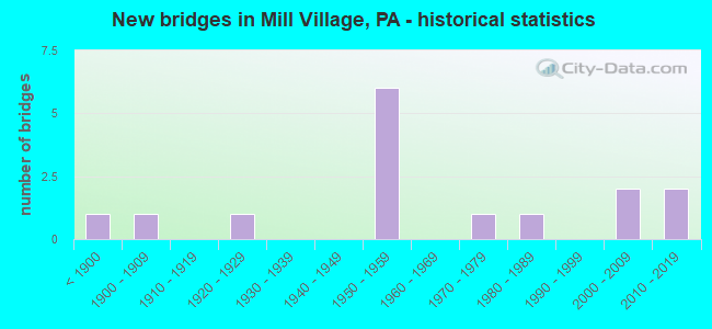
- New bridges - historical statistics
- 1Before 1900
- 11900-1909
- 11920-1929
- 61950-1959
- 11970-1979
- 11980-1989
- 22000-2009
- 22010-2019

- Reconstructed bridges - Historical Statistics
- 11950-1959
- 01960-1969
- 11970-1979
- 01980-1989
- 01990-1999
- 12000-2009
- 12010-2019


- Bridge Condition - Deck
- 9.1%Excellent
- 9.1%Very good
- 36.4%Good
- 27.3%Satisfactory
- 18.2%Fair

- Bridge Condition - Superstructure
- 18.2%Excellent
- 36.4%Very good
- 18.2%Satisfactory
- 18.2%Fair
- 9.1%Imminent failure

- Bridge Condition - Substructure
- 9.1%Excellent
- 18.2%Very good
- 18.2%Good
- 9.1%Satisfactory
- 36.4%Fair
- 9.1%Serious

- Bridge Condition - Channel
- 13.3%Very good
- 26.7%Good
- 13.3%Satisfactory
- 33.3%Fair
- 13.3%Poor

- Bridge Condition - Culverts
- 50.0%Good
- 25.0%Fair
- 25.0%Poor
Find on map >> Show street view
Structure Number: 15826, Location: LEBOUEF TOWNSHIP (Lat: 41.879175, Lng: -79.988747), Route carried "on" structure: US 6, Year Built: 1923, Year Reconstructed: 1955, Status: Open, Structure Length: 0.70m (2.30ft), Average Daily Traffic: 3,357 (year 2022), Truck Traffic: 10%, Average Future Daily Traffic: 3,540 (year 2032), Design Load: H 15, Features Intersected: OVER FRENCH CREEK TRIB
Minimum Vertical Clearance: 30+ m (98+ ft), Kilometerpoint: 4.968, Lanes on structure: 2, Base Highway Network: Yes, Owner: State Highway Agency, Approaching Roadway Width: 9.1m (29.9ft), Material/Design: Concrete, Design/Construction: Tee Beam, Number Of Spans In Main Unit: 1, Length of Maximum Span: 6.1m (20.0ft), Curb-To-Curb Width: 11.7m (38.4ft), Out-to-Out Width: 13.0m (42.7ft)
Condition: Deck: Satisfactory, Superstructure: Fair, Substructure: Fair, Channel: Fair, Operating Rating: 43.5 metric tons, Method Used To Determine Operating Rating: Load Factor (LF), Inventory Rating: 25.4 metric tons, Method Used To Determine Inventory Rating: Load Factor (LF), Structural Evaluation: Somewhat better than minimum adequacy, Deck Geometry: Somewhat better than minimum adequacy, Waterway Adequacy: Equal to present minimum criteria, Approach Roadway Alignment: Equal to present desirable criteria, Length Of Structure Improvement: 1.30m (4.27ft), Designated Inspection Frequency: Every 24 months, Inspection Date: June 2021, Bridge Improvement Cost: $5,000, Roadway Improvement Cost: $14,000, Total Project Cost: $64,000, Wearing Surface/Protective System: Wearing Surface: Bituminous, Membrane: Preformed Fabric
Find on map >> Show street view
Structure Number: 15827, Location: MILL VILLAGE BOROUGH (Lat: 41.875911, Lng: -79.982631), Route carried "on" structure: US 6, Year Built: 1955, Year Reconstructed: 1984, Status: Open, Structure Length: 1.37m (4.49ft), Average Daily Traffic: 3,357 (year 2022), Truck Traffic: 10%, Average Future Daily Traffic: 3,540 (year 2032), Design Load: HS 20, Features Intersected: OVER FRENCH CREEK BRANCH
Minimum Vertical Clearance: 30+ m (98+ ft), Kilometerpoint: 5.813, Lanes on structure: 2, Base Highway Network: Yes, Owner: State Highway Agency, Approaching Roadway Width: 6.7m (22.0ft), Skew: 3 degrees, Material/Design: Steel, Design/Construction: Stringer/Multi-beam, Number Of Spans In Main Unit: 1, Length of Maximum Span: 13.1m (43.0ft), Curb or Sidewalk Widths: Left: 0.2m (0.7ft), Right: 0.2m (0.7ft), Curb-To-Curb Width: 11.4m (37.4ft), Out-to-Out Width: 12.5m (41.0ft)
Condition: Deck: Fair, Superstructure: Satisfactory, Substructure: Fair, Channel: Fair, Operating Rating: 55.3 metric tons, Method Used To Determine Operating Rating: Load Factor (LF), Inventory Rating: 33.6 metric tons, Method Used To Determine Inventory Rating: Load Factor (LF), Structural Evaluation: Somewhat better than minimum adequacy, Deck Geometry: Somewhat better than minimum adequacy, Waterway Adequacy: Equal to present minimum criteria, Approach Roadway Alignment: Better than present minimum criteria, Length Of Structure Improvement: 2.10m (6.89ft), Designated Inspection Frequency: Every 24 months, Inspection Date: November 2020, Deck Structure Type: Concrete Cast-file-Place, Wearing Surface/Protective System: Wearing Surface: Bituminous, Membrane: Preformed Fabric, Deck Protection: Epoxy Coated Reinforcing
Find on map >> Show street view
Structure Number: 15829, Location: MILL VILLAGE BOROUGH (Lat: 41.876719, Lng: -79.971147), Route carried "on" structure: US 6, Year Built: 1984, Status: Open, Structure Length: 0.67m (2.20ft), Average Daily Traffic: 3,357 (year 2022), Truck Traffic: 10%, Average Future Daily Traffic: 3,540 (year 2032), Design Load: HS 20, Features Intersected: OVER FRENCH CREEK TRIB
Minimum Vertical Clearance: 30+ m (98+ ft), Kilometerpoint: 6.505, Lanes on structure: 2, Base Highway Network: Yes, Owner: State Highway Agency, Approaching Roadway Width: 8.5m (27.9ft), Skew: 3 degrees, Material/Design: Concrete, Design/Construction: Culvert, Number Of Spans In Main Unit: 1, Length of Maximum Span: 6.7m (22.0ft), Curb or Sidewalk Widths: Left: 1.1m (3.6ft), Right: 1.2m (3.9ft), Curb-To-Curb Width: 10.9m (35.8ft), Out-to-Out Width: 15.0m (49.2ft)
Condition: Channel: Good, Culverts: Good, Operating Rating: 54.4 metric tons, Method Used To Determine Operating Rating: Load Factor (LF), Inventory Rating: 32.7 metric tons, Method Used To Determine Inventory Rating: Load Factor (LF), Structural Evaluation: Better than present minimum criteria, Deck Geometry: Somewhat better than minimum adequacy, Waterway Adequacy: Equal to present desirable criteria, Approach Roadway Alignment: Equal to present desirable criteria, Length Of Structure Improvement: 1.30m (4.27ft), Designated Inspection Frequency: Every 24 months, Inspection Date: December 2020, Wearing Surface/Protective System: Wearing Surface: Bituminous, Membrane: Preformed Fabric
Find on map >> Show street view
Structure Number: 15885, Location: LEBOUEF TOWNSHIP (Lat: 41.895236, Lng: -79.992508), Route carried "on" structure: US 19, Year Built: 1952, Status: Open, Structure Length: 1.52m (4.99ft), Average Daily Traffic: 3,474 (year 2022), Truck Traffic: 6%, Average Future Daily Traffic: 4,788 (year 2032), Design Load: HS 20, Features Intersected: OVER FRENCH CREEK TRIB
Minimum Vertical Clearance: 30+ m (98+ ft), Kilometerpoint: 1.600, Lanes on structure: 2, Base Highway Network: Yes, Owner: State Highway Agency, Approaching Roadway Width: 9.1m (29.9ft), Material/Design: Concrete, Design/Construction: Tee Beam, Number Of Spans In Main Unit: 1, Length of Maximum Span: 14.3m (46.9ft), Curb-To-Curb Width: 12.2m (40.0ft), Out-to-Out Width: 13.3m (43.6ft)
Condition: Deck: Good, Superstructure: Satisfactory, Substructure: Satisfactory, Channel: Satisfactory, Operating Rating: 64.4 metric tons, Method Used To Determine Operating Rating: Load Factor (LF), Inventory Rating: 30.8 metric tons, Method Used To Determine Inventory Rating: Load Factor (LF), Structural Evaluation: Equal to present minimum criteria, Deck Geometry: Equal to present minimum criteria, Waterway Adequacy: Equal to present minimum criteria, Approach Roadway Alignment: Equal to present desirable criteria, Length Of Structure Improvement: 2.20m (7.22ft), Designated Inspection Frequency: Every 24 months, Inspection Date: August 2021, Bridge Improvement Cost: $5,000, Roadway Improvement Cost: $14,000, Total Project Cost: $64,000, Wearing Surface/Protective System: Wearing Surface: Bituminous, Membrane: Preformed Fabric
Find on map >> Show street view
Structure Number: 16228, Location: MILL VILLAGE BOROUGH (Lat: 41.877197, Lng: -79.971811), Route carried "on" structure: State highway , Year Built: 1951, Year Reconstructed: 2000, Status: Open, Structure Length: 1.34m (4.40ft), Average Daily Traffic: 2,157 (year 2021), Truck Traffic: 9%, Average Future Daily Traffic: 2,014 (year 2032), Design Load: HS 20, Features Intersected: OVER FRENCH CREEK BRANCH, Facility Carried by Structure: SR 2003, MAIN ST.
Minimum Vertical Clearance: 30+ m (98+ ft), Kilometerpoint: 3.428, Lanes on structure: 2, Owner: State Highway Agency, Approaching Roadway Width: 6.7m (22.0ft), Skew: 4 degrees, Material/Design: Steel, Design/Construction: Stringer/Multi-beam, Number Of Spans In Main Unit: 1, Length of Maximum Span: 12.8m (42.0ft), Curb or Sidewalk Widths: Left: 1.5m (4.9ft), Right: 0.2m (0.7ft), Curb-To-Curb Width: 8.2m (26.9ft), Out-to-Out Width: 10.9m (35.8ft)
Condition: Deck: Satisfactory, Superstructure: Fair, Substructure: Fair, Channel: Poor, Operating Rating: 38.1 metric tons, Method Used To Determine Operating Rating: Load Factor (LF), Inventory Rating: 22.7 metric tons, Method Used To Determine Inventory Rating: Load Factor (LF), Structural Evaluation: Somewhat better than minimum adequacy, Deck Geometry: High priority of corrective action, Waterway Adequacy: Better than present minimum criteria, Approach Roadway Alignment: Equal to present desirable criteria, Length Of Structure Improvement: 1.30m (4.27ft), Designated Inspection Frequency: Every 24 months, Inspection Date: November 2021, Bridge Improvement Cost: $3,000, Roadway Improvement Cost: $12,000, Total Project Cost: $35,000, Deck Structure Type: Closed Grating, Wearing Surface/Protective System: Wearing Surface: Bituminous
Find on map >> Show street view
Structure Number: 16229, Location: LEBOUEF TOWNSHIP (Lat: 41.900658, Lng: -79.970744), Route carried "on" structure: State highway , Year Built: 1976, Status: Open, Structure Length: 4.39m (14.40ft), Average Daily Traffic: 2,157 (year 2021), Truck Traffic: 9%, Average Future Daily Traffic: 2,014 (year 2032), Design Load: HS 20, Features Intersected: OVER FRENCH CREEK, Facility Carried by Structure: SR 2003,FLATT ROAD
Minimum Vertical Clearance: 30+ m (98+ ft), Kilometerpoint: 5.935, Lanes on structure: 2, Owner: State Highway Agency, Approaching Roadway Width: 6.7m (22.0ft), Material/Design: Prestressed concrete, Design/Construction: Box Beam or Girders - Single/Spread, Number Of Spans In Main Unit: 2, Length of Maximum Span: 21.6m (70.9ft), Curb or Sidewalk Widths: Left: 0.2m (0.7ft), Right: 0.2m (0.7ft), Curb-To-Curb Width: 13.0m (42.7ft), Out-to-Out Width: 13.9m (45.6ft)
Condition: Deck: Satisfactory, Superstructure: Very good, Substructure: Good, Channel: Satisfactory, Operating Rating: 89.8 metric tons, Method Used To Determine Operating Rating: Load Factor (LF), Inventory Rating: 59.9 metric tons, Method Used To Determine Inventory Rating: Load Factor (LF), Structural Evaluation: Better than present minimum criteria, Deck Geometry: Equal to present minimum criteria, Waterway Adequacy: Superior to present desirable criteria, Approach Roadway Alignment: Equal to present desirable criteria, Length Of Structure Improvement: 4.40m (14.44ft), Designated Inspection Frequency: Every 48 months, Underwater Inspection Frequency: Every 60 months, Inspection Date: September 2019, Underwater Inspection Date: June 2021, Bridge Improvement Cost: $16,000, Roadway Improvement Cost: $48,000, Total Project Cost: $219,000, Deck Structure Type: Concrete Cast-file-Place, Wearing Surface/Protective System: Wearing Surface: Bituminous, Membrane: Preformed Fabric
Find on map >> Show street view
Structure Number: 1623, Location: LEBOUEF TOWNSHIP (Lat: 41.905200, Lng: -79.971261), Route carried "on" structure: State highway , Year Built: 1954, Status: Open, Structure Length: 6.52m (21.39ft), Average Daily Traffic: 2,157 (year 2021), Truck Traffic: 9%, Average Future Daily Traffic: 2,014 (year 2032), Design Load: H 20, Features Intersected: OVER FRENCH CK OVERFLOW, Facility Carried by Structure: SR 2003,FLATT ROAD
Minimum Vertical Clearance: 30+ m (98+ ft), Kilometerpoint: 6.344, Lanes on structure: 2, Owner: State Highway Agency, Approaching Roadway Width: 6.7m (22.0ft), Material/Design: Steel, Design/Construction: Culvert, Number Of Spans In Main Unit: 16, Length of Maximum Span: 4.0m (13.1ft)
Condition: Channel: Good, Culverts: Fair, Operating Rating: 49.0 metric tons, Method Used To Determine Operating Rating: Field evaluation and documented engineering judgment, Inventory Rating: 32.7 metric tons, Method Used To Determine Inventory Rating: Field evaluation and documented engineering judgment, Structural Evaluation: Somewhat better than minimum adequacy, Waterway Adequacy: Superior to present desirable criteria, Approach Roadway Alignment: Equal to present desirable criteria, Length Of Structure Improvement: 7.50m (24.61ft), Designated Inspection Frequency: Every 24 months, Inspection Date: April 2020, Bridge Improvement Cost: $65,000, Roadway Improvement Cost: $191,000, Total Project Cost: $875,000
Find on map >> Show street view
Structure Number: 16239, Location: LEBOEUF TOWNSHIP (Lat: 41.892897, Lng: -79.935169), Route carried "on" structure: State highway , Year Built: 1904, Year Reconstructed: 2019, Status: Open, Structure Length: 1.07m (3.51ft), Average Daily Traffic: 191 (year 2021), Truck Traffic: 6%, Average Future Daily Traffic: 186 (year 2032), Design Load: HL 93, Features Intersected: OVER FRENCH CREEK TRIB, Facility Carried by Structure: SR 2008,STONE QURY
Minimum Vertical Clearance: 30+ m (98+ ft), Kilometerpoint: 0.000, Lanes on structure: 2, Owner: State Highway Agency, Approaching Roadway Width: 6.1m (20.0ft), Material/Design: Concrete, Design/Construction: Channel Beam, Number Of Spans In Main Unit: 1, Length of Maximum Span: 10.7m (35.1ft), Curb-To-Curb Width: 7.7m (25.3ft), Out-to-Out Width: 8.3m (27.2ft)
Condition: Deck: Excellent, Superstructure: Excellent, Substructure: Fair, Channel: Poor, Operating Rating: 95.3 metric tons, Method Used To Determine Operating Rating: Load Factor (LF), Inventory Rating: 57.2 metric tons, Method Used To Determine Inventory Rating: Load Factor (LF), Structural Evaluation: Somewhat better than minimum adequacy, Deck Geometry: Somewhat better than minimum adequacy, Waterway Adequacy: Better than present minimum criteria, Approach Roadway Alignment: Equal to present desirable criteria, Length Of Structure Improvement: 0.80m (2.62ft), Designated Inspection Frequency: Every 24 months, Inspection Date: November 2020, Bridge Improvement Cost: $3,000, Roadway Improvement Cost: $25,000, Total Project Cost: $39,000, Deck Structure Type: Corrugated Steel, Wearing Surface/Protective System: Wearing Surface: Gravel
Find on map >> Show street view
Structure Number: 16449, Location: 1500' NW OF STONE QUARRY (Lat: 41.894242, Lng: -79.921378), Route carried "on" structure: City street 7211, Year Built: 1889, Status: Closed, Structure Length: 3.69m (12.11ft), Average Daily Traffic: 30 (year 2013), Truck Traffic: 15%, Average Future Daily Traffic: 33 (year 2033), Features Intersected: FRENCH CREEK, Facility Carried by Structure: T-636 DEWEY ROAD
Minimum Vertical Clearance: 3.17m (10.40ft), Kilometerpoint: 0.000, Lanes on structure: 1, Owner: Town or Township Highway Agency, Approaching Roadway Width: 6.4m (21.0ft), Material/Design: Steel, Design/Construction: Truss - Thru, Number Of Spans In Main Unit: 1, Length of Maximum Span: 36.3m (119.1ft), Curb-To-Curb Width: 4.0m (13.1ft), Out-to-Out Width: 4.2m (13.8ft)
Condition: Deck: Fair, Superstructure: Imminent failure, Substructure: Serious, Channel: Good, Operating Rating: 6.4 metric tons, Method Used To Determine Operating Rating: Load Factor (LF), Inventory Rating: 3.6 metric tons, Method Used To Determine Inventory Rating: Load Factor (LF), Waterway Adequacy: Equal to present desirable criteria, Approach Roadway Alignment: Meets minimum limits, Bridge Posting: Required (Relationship of Operating Rating to Maximum Legal Load: > 39.9% below), Length Of Structure Improvement: 4.60m (15.09ft), Designated Inspection Frequency: Every 24 months, Inspection Date: July 2021, Bridge Improvement Cost: $57,000, Roadway Improvement Cost: $169,000, Total Project Cost: $774,000, Deck Structure Type: Wood or Timber
Find on map >> Show street view
Structure Number: 43539, Location: LEBOUEF TOWNSHIP (Lat: 41.882281, Lng: -79.999356), Route carried "on" structure: US 6, Year Built: 2006, Status: Open, Structure Length: 5.09m (16.70ft), Average Daily Traffic: 3,357 (year 2022), Truck Traffic: 10%, Average Future Daily Traffic: 3,540 (year 2032), Design Load: HL 93, Features Intersected: OVER FRENCH CREEK
Minimum Vertical Clearance: 30+ m (98+ ft), Kilometerpoint: 4.136, Lanes on structure: 2, Base Highway Network: Yes, Owner: State Highway Agency, Approaching Roadway Width: 12.2m (40.0ft), Material/Design: Steel continuous, Design/Construction: Stringer/Multi-beam, Number Of Spans In Main Unit: 1, Length of Maximum Span: 49.1m (161.1ft), Curb or Sidewalk Widths: Left: 0.2m (0.7ft), Right: 0.2m (0.7ft), Curb-To-Curb Width: 12.2m (40.0ft), Out-to-Out Width: 13.2m (43.3ft)
Condition: Deck: Very good, Superstructure: Very good, Substructure: Very good, Channel: Very good, Operating Rating: 78.9 metric tons, Method Used To Determine Operating Rating: Load Factor (LF), Inventory Rating: 60.8 metric tons, Method Used To Determine Inventory Rating: Load Factor (LF), Structural Evaluation: Equal to present desirable criteria, Deck Geometry: Equal to present minimum criteria, Waterway Adequacy: Superior to present desirable criteria, Approach Roadway Alignment: Equal to present desirable criteria, Designated Inspection Frequency: Every 24 months, Inspection Date: October 2020, Deck Structure Type: Concrete Cast-file-Place, Wearing Surface/Protective System: Wearing Surface: Monolithic Concrete, Deck Protection: Epoxy Coated Reinforcing
Find on map >> Show street view
Structure Number: 4615, Location: 850' SOUTH OF SR0006 (Lat: 41.874483, Lng: -79.968658), Route carried "on" structure: City street , Year Built: 2008, Status: Open, Structure Length: 0.70m (2.30ft), Average Daily Traffic: 72 (year 2013), Truck Traffic: 3%, Average Future Daily Traffic: 78 (year 2033), Design Load: HS 20, Features Intersected: FRENCH CREEK TRIB, Facility Carried by Structure: DEPOT STREET
Minimum Vertical Clearance: 30+ m (98+ ft), Kilometerpoint: 0.000, Lanes on structure: 2, Owner: Town or Township Highway Agency, Approaching Roadway Width: 6.1m (20.0ft), Skew: 3 degrees, Material/Design: Steel, Design/Construction: Culvert, Number Of Spans In Main Unit: 1, Length of Maximum Span: 7.0m (23.0ft)
Condition: Channel: Fair, Culverts: Good, Operating Rating: 45.4 metric tons, Method Used To Determine Operating Rating: Field evaluation and documented engineering judgment, Inventory Rating: 32.7 metric tons, Method Used To Determine Inventory Rating: Field evaluation and documented engineering judgment, Structural Evaluation: Better than present minimum criteria, Waterway Adequacy: Better than present minimum criteria, Approach Roadway Alignment: Equal to present desirable criteria, Designated Inspection Frequency: Every 24 months, Inspection Date: July 2021
Find on map >> Show street view
Structure Number: 46542, Location: ROCKDALE TOWNSHIP (Lat: 41.810350, Lng: -79.984061), Route carried "on" structure: State highway , Year Built: 2011, Status: Open, Structure Length: 5.24m (17.19ft), Average Daily Traffic: 623 (year 2022), Truck Traffic: 20%, Average Future Daily Traffic: 728 (year 2032), Design Load: HL 93, Features Intersected: FRENCH CREEK, Facility Carried by Structure: MILLER STATION RD
Minimum Vertical Clearance: 30+ m (98+ ft), Kilometerpoint: 5.132, Lanes on structure: 2, Owner: State Highway Agency, Approaching Roadway Width: 8.2m (26.9ft), Skew: 3 degrees, Material/Design: Prestressed concrete, Design/Construction: Box Beam or Girders - Single/Spread, Number Of Spans In Main Unit: 2, Length of Maximum Span: 25.6m (84.0ft), Curb or Sidewalk Widths: Left: 0.2m (0.7ft), Right: 0.2m (0.7ft), Curb-To-Curb Width: 7.9m (25.9ft), Out-to-Out Width: 9.0m (29.5ft)
Condition: Deck: Good, Superstructure: Very good, Substructure: Very good, Channel: Good, Operating Rating: 53.8 metric tons, Method Used To Determine Operating Rating: Assigned ratings based on Load and Resistance Factor Design (LRFD) reported by rating factor (RF) using HL93 loadings, Inventory Rating: 34.0 metric tons, Method Used To Determine Inventory Rating: Assigned ratings based on Load and Resistance Factor Design (LRFD) reported by rating factor (RF) using HL93 loadings, Structural Evaluation: Equal to present desirable criteria, Deck Geometry: Somewhat better than minimum adequacy, Waterway Adequacy: Superior to present desirable criteria, Approach Roadway Alignment: Somewhat better than minimum adequacy, Designated Inspection Frequency: Every 48 months, Underwater Inspection Frequency: Every 60 months, Inspection Date: August 2020, Underwater Inspection Date: October 2017, Deck Structure Type: Concrete Cast-file-Place, Wearing Surface/Protective System: Wearing Surface: Monolithic Concrete, Deck Protection: Epoxy Coated Reinforcing
Find on map >> Show street view
Structure Number: 46579, Location: ROCKDALE TWP (Lat: 41.814875, Lng: -79.957408), Route carried "on" structure: State highway , Year Built: 2011, Status: Open, Structure Length: 2.56m (8.40ft), Average Daily Traffic: 477 (year 2017), Truck Traffic: 18%, Average Future Daily Traffic: 341 (year 2032), Design Load: HL 93, Features Intersected: KELLY RUN, Facility Carried by Structure: SR 1035,Brown Hill
Minimum Vertical Clearance: 30+ m (98+ ft), Kilometerpoint: 6.207, Lanes on structure: 2, Owner: State Highway Agency, Approaching Roadway Width: 7.6m (24.9ft), Skew: 1 degrees, Material/Design: Prestressed concrete, Design/Construction: Box Beam or Girders - Single/Spread, Number Of Spans In Main Unit: 1, Length of Maximum Span: 24.4m (80.1ft), Curb or Sidewalk Widths: Left: 0.2m (0.7ft), Right: 0.2m (0.7ft), Curb-To-Curb Width: 7.4m (24.3ft), Out-to-Out Width: 8.4m (27.6ft)
Condition: Deck: Good, Superstructure: Excellent, Substructure: Excellent, Channel: Very good, Operating Rating: 64.8 metric tons, Method Used To Determine Operating Rating: Assigned ratings based on Load and Resistance Factor Design (LRFD) reported by rating factor (RF) using HL93 loadings, Inventory Rating: 34.3 metric tons, Method Used To Determine Inventory Rating: Assigned ratings based on Load and Resistance Factor Design (LRFD) reported by rating factor (RF) using HL93 loadings, Structural Evaluation: Superior to present desirable criteria, Deck Geometry: Meets minimum limits, Waterway Adequacy: Equal to present desirable criteria, Approach Roadway Alignment: Somewhat better than minimum adequacy, Designated Inspection Frequency: Every 48 months, Inspection Date: August 2020, Deck Structure Type: Concrete Cast-file-Place, Wearing Surface/Protective System: Wearing Surface: Monolithic Concrete, Deck Protection: Epoxy Coated Reinforcing
Find on map >> Show street view
Structure Number: 52848, Location: 250' W OF T-560 (Lat: 41.896811, Lng: -79.995844), Route carried "on" structure: Other road 373, Year Built: 1950, Status: Open, Structure Length: 0.67m (2.20ft), Average Daily Traffic: 50 (year 2017), Truck Traffic: 5%, Average Future Daily Traffic: 60 (year 2030), Design Load: H 20, Features Intersected: TRIB TO FRENCH CREEK
Minimum Vertical Clearance: 30+ m (98+ ft), Kilometerpoint: 0.000, Lanes on structure: 2, Toll: Toll bridge, Owner: Town or Township Highway Agency, Approaching Roadway Width: 6.1m (20.0ft), Skew: 4 degrees, Material/Design: Steel, Design/Construction: Culvert, Number Of Spans In Main Unit: 2, Length of Maximum Span: 3.0m (9.8ft)
Condition: Channel: Fair, Culverts: Poor, Operating Rating: 49.0 metric tons, Method Used To Determine Operating Rating: Load Factor (LF), Inventory Rating: 32.7 metric tons, Method Used To Determine Inventory Rating: Load Factor (LF), Structural Evaluation: Meets minimum limits, Waterway Adequacy: Superior to present desirable criteria, Approach Roadway Alignment: Equal to present desirable criteria, Designated Inspection Frequency: Every 24 months, Other Special Inspection Frequency: Every 6 months, Inspection Date: October 2021, Other Special Inspection Date: October 2021
Find on map >> Show street view
Structure Number: 5285, Location: 0.5 MI N SR 19 (Lat: 41.895775, Lng: -79.995219), Route carried "on" structure: Other road , Year Built: 1950, Status: Open, Structure Length: 1.01m (3.31ft), Average Daily Traffic: 110 (year 2015), Truck Traffic: 5%, Average Future Daily Traffic: 120 (year 2035), Design Load: HS 20, Features Intersected: TRIB TO FRENCH CK, Facility Carried by Structure: T-560 OLD RT 19 N
Minimum Vertical Clearance: 30+ m (98+ ft), Kilometerpoint: 0.000, Lanes on structure: 2, Toll: Toll bridge, Owner: Town or Township Highway Agency, Approaching Roadway Width: 4.6m (15.1ft), Material/Design: Steel, Design/Construction: Stringer/Multi-beam, Number Of Spans In Main Unit: 1, Length of Maximum Span: 10.1m (33.1ft), Curb or Sidewalk Widths: Left: 0.1m (0.3ft), Right: 0.1m (0.3ft), Curb-To-Curb Width: 4.7m (15.4ft), Out-to-Out Width: 5.0m (16.4ft)
Condition: Deck: Good, Superstructure: Very good, Substructure: Good, Channel: Fair, Operating Rating: 95.3 metric tons, Method Used To Determine Operating Rating: Load Factor (LF), Inventory Rating: 57.2 metric tons, Method Used To Determine Inventory Rating: Load Factor (LF), Structural Evaluation: Better than present minimum criteria, Deck Geometry: High priority of replacement, Waterway Adequacy: Better than present minimum criteria, Approach Roadway Alignment: Equal to present minimum criteria, Designated Inspection Frequency: Every 24 months, Inspection Date: October 2021, Deck Structure Type: Wood or Timber