Bridge Statistics for Moab, Utah (UT)
Condition, Traffic, Stress, Structural Evaluation, Project Costs
- National Bridge Inventory (NBI) Statistics
- 19Number of bridges
- 344ft / 105mTotal length
- $3,000Total costs
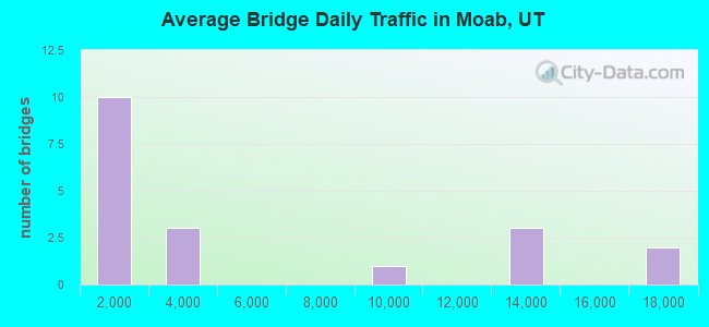
- 99,018Total average daily traffic
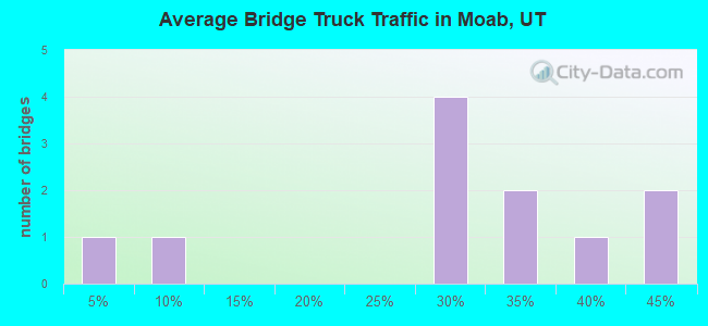
- 28,024Total average daily truck traffic
- 123,650Total future (year 2028) average daily traffic
- National Bridge Inventory (NBI) Registered Bridges for Moab
- No street view available for this location
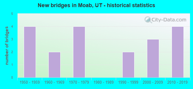
- New bridges - historical statistics
- 41950-1959
- 21960-1969
- 41970-1979
- 21990-1999
- 32000-2009
- 42010-2019
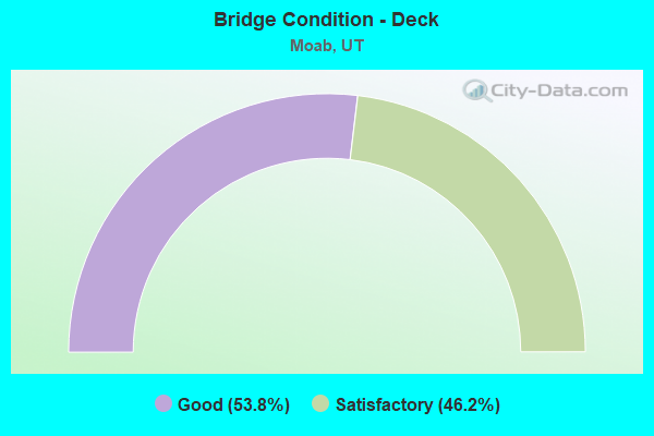
- Bridge Condition - Deck
- 53.8%Good
- 46.2%Satisfactory
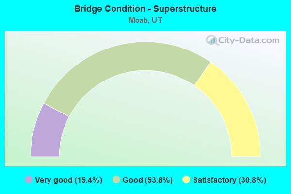
- Bridge Condition - Superstructure
- 15.4%Very good
- 53.8%Good
- 30.8%Satisfactory
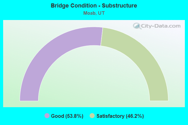
- Bridge Condition - Substructure
- 53.8%Good
- 46.2%Satisfactory
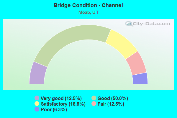
- Bridge Condition - Channel
- 12.5%Very good
- 50.0%Good
- 18.8%Satisfactory
- 12.5%Fair
- 6.3%Poor
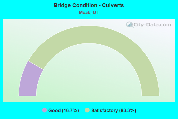
- Bridge Condition - Culverts
- 16.7%Good
- 83.3%Satisfactory
Find on map >> Show street view
Structure Number: 19002D, Location: 750 SOUTH 400 EAST, MOAB (Lat: 38.565300, Lng: -109.542900), Route carried "on" structure: City street 1690, Year Built: 1999, Status: Open, Structure Length: 0.72m (2.36ft), Average Daily Traffic: 519 (year 2020), Average Future Daily Traffic: 649 (year 2040), Design Load: HS 20+Mod, Features Intersected: PEDESTRIAN UNDERPASS, Facility Carried by Structure: 400 EAST STREET
Minimum Vertical Clearance: 30+ m (98+ ft), Kilometerpoint: 0.861, Lanes on structure: 2, Owner: City or Municipal Highway Agency, Approaching Roadway Width: 9.8m (32.2ft), Material/Design: Concrete, Design/Construction: Frame, Number Of Spans In Main Unit: 1, Length of Maximum Span: 6.7m (22.0ft), Curb or Sidewalk Widths: Left: 0.0m, Right: 1.2m (3.9ft), Curb-To-Curb Width: 9.8m (32.2ft), Out-to-Out Width: 16.7m (54.8ft)
Condition: Deck: Good, Superstructure: Good, Substructure: Good, Operating Rating: 49.6 metric tons, Method Used To Determine Operating Rating: Load and Resistance Factor Rating (LRFR) rating reported by rating factor(RF) method using HL-93 loadings, Inventory Rating: 40.2 metric tons, Method Used To Determine Inventory Rating: Load and Resistance Factor Rating (LRFR) rating reported by rating factor(RF) method using HL-93 loadings, Structural Evaluation: Better than present minimum criteria, Deck Geometry: Equal to present minimum criteria, Approach Roadway Alignment: Equal to present desirable criteria, Designated Inspection Frequency: Every 24 months, Inspection Date: January 2022, Deck Structure Type: Concrete Precast Panels, Wearing Surface/Protective System: Wearing Surface: Bituminous
Find on map >> Show street view
Structure Number: 19003V, Location: 100 SOUTH 500 WEST (Lat: 38.572900, Lng: -109.561300), Route carried "on" structure: City street 1691, Year Built: 2003, Status: Open, Structure Length: 0.76m (2.49ft), Average Daily Traffic: 2,508 (year 2020), Average Future Daily Traffic: 3,135 (year 2040), Design Load: HS 20+Mod, Features Intersected: PEDESTRIAN WALKWAY, Facility Carried by Structure: 500 WEST STREET
Minimum Vertical Clearance: 30+ m (98+ ft), Kilometerpoint: 1.720, Lanes on structure: 2, Owner: City or Municipal Highway Agency, Approaching Roadway Width: 9.1m (29.9ft), Material/Design: Steel, Design/Construction: Culvert, Number Of Spans In Main Unit: 1, Length of Maximum Span: 7.6m (24.9ft), Curb or Sidewalk Widths: Left: 1.8m (5.9ft), Right: 0.0m
Condition: Culverts: Good, Operating Rating: 97.2 metric tons, Method Used To Determine Operating Rating: Load and Resistance Factor Rating (LRFR) rating reported by rating factor(RF) method using HL-93 loadings, Inventory Rating: 96.9 metric tons, Method Used To Determine Inventory Rating: Load and Resistance Factor Rating (LRFR) rating reported by rating factor(RF) method using HL-93 loadings, Structural Evaluation: Better than present minimum criteria, Approach Roadway Alignment: Equal to present desirable criteria, Designated Inspection Frequency: Every 24 months, Inspection Date: January 2022
Find on map >> Show street view
Structure Number: 19007E, Location: 150 EAST 300 SOUTH, MOAB (Lat: 38.568667, Lng: -109.547931), Route carried "on" structure: City street 1696, Year Built: 1972, Status: Open, Structure Length: 1.68m (5.51ft), Average Daily Traffic: 519 (year 2020), Average Future Daily Traffic: 649 (year 2040), Design Load: HS 20+Mod, Features Intersected: MILL CREEK, Facility Carried by Structure: 300 SOUTH STREET
Minimum Vertical Clearance: 30+ m (98+ ft), Kilometerpoint: 0.251, Lanes on structure: 2, Owner: City or Municipal Highway Agency, Approaching Roadway Width: 21.2m (69.6ft), Skew: 3 degrees, Material/Design: Concrete continuous, Design/Construction: Culvert, Number Of Spans In Main Unit: 3, Length of Maximum Span: 6.7m (22.0ft), Curb or Sidewalk Widths: Left: 1.2m (3.9ft), Right: 1.2m (3.9ft), Curb-To-Curb Width: 21.2m (69.6ft), Out-to-Out Width: 32.1m (105.3ft)
Condition: Channel: Good, Culverts: Satisfactory, Operating Rating: 45.0 metric tons, Method Used To Determine Operating Rating: Load Factor (LF) rating reported by rating factor (RF) method using MS18 loading, Inventory Rating: 23.7 metric tons, Method Used To Determine Inventory Rating: Load and Resistance Factor Rating (LRFR) rating reported by rating factor(RF) method using HL-93 loadings, Structural Evaluation: Equal to present minimum criteria, Deck Geometry: Superior to present desirable criteria, Waterway Adequacy: Equal to present minimum criteria, Approach Roadway Alignment: Equal to present desirable criteria, Designated Inspection Frequency: Every 24 months, Inspection Date: January 2022
Find on map >> Show street view
Structure Number: 19008F, Location: 100 SOUTH 500 WEST, MOAB (Lat: 38.572300, Lng: -109.561300), Route carried "on" structure: City street 1691, Year Built: 1969, Status: Open, Structure Length: 3.41m (11.19ft), Average Daily Traffic: 2,508 (year 2020), Average Future Daily Traffic: 3,135 (year 2040), Design Load: HS 20+Mod, Features Intersected: MILL CREEK, Facility Carried by Structure: 500 WEST STREET
Minimum Vertical Clearance: 30+ m (98+ ft), Kilometerpoint: 1.651, Lanes on structure: 2, Owner: City or Municipal Highway Agency, Approaching Roadway Width: 8.5m (27.9ft), Material/Design: Prestressed concrete, Design/Construction: Stringer/Multi-beam, Number Of Spans In Main Unit: 2, Length of Maximum Span: 16.5m (54.1ft), Curb or Sidewalk Widths: Left: 1.6m (5.2ft), Right: 0.0m, Curb-To-Curb Width: 8.5m (27.9ft), Out-to-Out Width: 9.7m (31.8ft)
Condition: Deck: Satisfactory, Superstructure: Good, Substructure: Good, Channel: Fair, Operating Rating: 49.6 metric tons, Method Used To Determine Operating Rating: Load and Resistance Factor Rating (LRFR) rating reported by rating factor(RF) method using HL-93 loadings, Inventory Rating: 36.9 metric tons, Method Used To Determine Inventory Rating: Load Factor (LF) rating reported by rating factor (RF) method using MS18 loading, Structural Evaluation: Better than present minimum criteria, Deck Geometry: Meets minimum limits, Waterway Adequacy: Equal to present minimum criteria, Approach Roadway Alignment: Equal to present desirable criteria, Designated Inspection Frequency: Every 24 months, Inspection Date: January 2020, Deck Structure Type: Concrete Cast-file-Place, Wearing Surface/Protective System: Wearing Surface: Bituminous
Find on map >> Show street view
Structure Number: 19037F, Location: 500 SOUTH 400 EAST, MOAB (Lat: 38.565600, Lng: -109.542900), Route carried "on" structure: City street 1690, Year Built: 1972, Status: Open, Structure Length: 3.08m (10.10ft), Average Daily Traffic: 519 (year 2020), Average Future Daily Traffic: 649 (year 2040), Design Load: HS 20+Mod, Features Intersected: MILL CREEK, Facility Carried by Structure: 400 EAST STREET
Minimum Vertical Clearance: 30+ m (98+ ft), Kilometerpoint: 0.890, Lanes on structure: 2, Owner: City or Municipal Highway Agency, Approaching Roadway Width: 9.8m (32.2ft), Material/Design: Prestressed concrete, Design/Construction: Stringer/Multi-beam, Number Of Spans In Main Unit: 1, Length of Maximum Span: 29.3m (96.1ft), Curb or Sidewalk Widths: Left: 1.7m (5.6ft), Right: 1.2m (3.9ft), Curb-To-Curb Width: 9.8m (32.2ft), Out-to-Out Width: 10.4m (34.1ft)
Condition: Deck: Good, Superstructure: Good, Substructure: Satisfactory, Channel: Good, Operating Rating: 32.4 metric tons, Method Used To Determine Operating Rating: Load and Resistance Factor Rating (LRFR) rating reported by rating factor(RF) method using HL-93 loadings, Inventory Rating: 18.8 metric tons, Method Used To Determine Inventory Rating: Load and Resistance Factor Rating (LRFR) rating reported by rating factor(RF) method using HL-93 loadings, Structural Evaluation: Somewhat better than minimum adequacy, Deck Geometry: Equal to present minimum criteria, Waterway Adequacy: Equal to present minimum criteria, Approach Roadway Alignment: Equal to present desirable criteria, Designated Inspection Frequency: Every 24 months, Inspection Date: January 2022, Deck Structure Type: Concrete Cast-file-Place, Wearing Surface/Protective System: Wearing Surface: Bituminous
Find on map >> Show street view
Structure Number: 19038F, Location: 800 SOUTH 400 EAST (Lat: 38.561386, Lng: -109.542867), Route carried "on" structure: City street 1690, Year Built: 1972, Status: Open, Structure Length: 3.05m (10.01ft), Average Daily Traffic: 519 (year 2020), Average Future Daily Traffic: 649 (year 2040), Design Load: HS 20+Mod, Features Intersected: PACK CREEK, Facility Carried by Structure: 400 EAST STREET
Minimum Vertical Clearance: 30+ m (98+ ft), Kilometerpoint: 0.424, Lanes on structure: 2, Owner: City or Municipal Highway Agency, Approaching Roadway Width: 9.8m (32.2ft), Material/Design: Prestressed concrete, Design/Construction: Stringer/Multi-beam, Number Of Spans In Main Unit: 1, Length of Maximum Span: 29.3m (96.1ft), Curb or Sidewalk Widths: Left: 0.0m, Right: 1.2m (3.9ft), Curb-To-Curb Width: 9.8m (32.2ft), Out-to-Out Width: 10.4m (34.1ft)
Condition: Deck: Good, Superstructure: Satisfactory, Substructure: Satisfactory, Channel: Fair, Operating Rating: 36.9 metric tons, Method Used To Determine Operating Rating: Load and Resistance Factor Rating (LRFR) rating reported by rating factor(RF) method using HL-93 loadings, Inventory Rating: 23.7 metric tons, Method Used To Determine Inventory Rating: Load and Resistance Factor Rating (LRFR) rating reported by rating factor(RF) method using HL-93 loadings, Structural Evaluation: Equal to present minimum criteria, Deck Geometry: Equal to present minimum criteria, Waterway Adequacy: Equal to present minimum criteria, Approach Roadway Alignment: Equal to present desirable criteria, Designated Inspection Frequency: Every 24 months, Inspection Date: January 2020, Deck Structure Type: Concrete Cast-file-Place, Wearing Surface/Protective System: Wearing Surface: Monolithic Concrete
Find on map >> Show street view
Structure Number: 19040F, Location: 1000 EAST 800 SOUTH, MOAB (Lat: 38.563592, Lng: -109.533472), Route carried "on" structure: City street 1692, Year Built: 1977, Status: Open, Structure Length: 3.88m (12.73ft), Average Daily Traffic: 104 (year 2020), Average Future Daily Traffic: 130 (year 2040), Design Load: HS 20+Mod, Features Intersected: MILL CREEK, Facility Carried by Structure: 1000 EAST STREET
Minimum Vertical Clearance: 30+ m (98+ ft), Kilometerpoint: 11.384, Lanes on structure: 2, Owner: City or Municipal Highway Agency, Approaching Roadway Width: 9.8m (32.2ft), Skew: 5 degrees, Material/Design: Prestressed concrete, Design/Construction: Stringer/Multi-beam, Number Of Spans In Main Unit: 1, Length of Maximum Span: 37.4m (122.7ft), Curb or Sidewalk Widths: Left: 1.2m (3.9ft), Right: 1.7m (5.6ft), Curb-To-Curb Width: 9.8m (32.2ft), Out-to-Out Width: 11.8m (38.7ft)
Condition: Deck: Satisfactory, Superstructure: Satisfactory, Substructure: Good, Channel: Satisfactory, Operating Rating: 47.0 metric tons, Method Used To Determine Operating Rating: Load and Resistance Factor Rating (LRFR) rating reported by rating factor(RF) method using HL-93 loadings, Inventory Rating: 32.4 metric tons, Method Used To Determine Inventory Rating: Load Factor (LF) rating reported by rating factor (RF) method using MS18 loading, Structural Evaluation: Equal to present minimum criteria, Deck Geometry: Better than present minimum criteria, Waterway Adequacy: Better than present minimum criteria, Approach Roadway Alignment: Equal to present minimum criteria, Designated Inspection Frequency: Every 24 months, Inspection Date: January 2020, Deck Structure Type: Concrete Cast-file-Place, Wearing Surface/Protective System: Wearing Surface: Bituminous, Membrane: Preformed Fabric
Find on map >> Show street view
Structure Number: 19041F, Location: MILL CREEK DRIVE IN MOAB (Lat: 38.555258, Lng: -109.524647), Route carried "on" structure: County highway 1692, Year Built: 2011, Status: Open, Structure Length: 4.10m (13.45ft), Average Daily Traffic: 2,577 (year 2020), Average Future Daily Traffic: 3,221 (year 2040), Design Load: HL 93, Features Intersected: PACK CREEK, Facility Carried by Structure: MILL CREEK DRIVE
Minimum Vertical Clearance: 30+ m (98+ ft), Kilometerpoint: 10.126, Lanes on structure: 2, Owner: County Highway Agency, Approaching Roadway Width: 11.0m (36.1ft), Skew: 3 degrees, Material/Design: Prestressed concrete, Design/Construction: Stringer/Multi-beam, Number Of Spans In Main Unit: 1, Length of Maximum Span: 39.6m (129.9ft), Curb or Sidewalk Widths: Left: 0.0m, Right: 3.2m (10.5ft), Curb-To-Curb Width: 11.0m (36.1ft), Out-to-Out Width: 15.0m (49.2ft)
Condition: Deck: Satisfactory, Superstructure: Very good, Substructure: Good, Channel: Very good, Operating Rating: 76.1 metric tons, Method Used To Determine Operating Rating: Load and Resistance Factor Rating (LRFR) rating reported by rating factor(RF) method using HL-93 loadings, Inventory Rating: 47.6 metric tons, Method Used To Determine Inventory Rating: Load and Resistance Factor Rating (LRFR) rating reported by rating factor(RF) method using HL-93 loadings, Structural Evaluation: Better than present minimum criteria, Deck Geometry: Somewhat better than minimum adequacy, Waterway Adequacy: Equal to present desirable criteria, Approach Roadway Alignment: Equal to present desirable criteria, Designated Inspection Frequency: Every 24 months, Inspection Date: January 2020, Deck Structure Type: Concrete Cast-file-Place, Wearing Surface/Protective System: Wearing Surface: Monolithic Concrete, Deck Protection: Epoxy Coated Reinforcing
Find on map >> Show street view
Structure Number: C 756, Location: 3.1 MILES NORTH OF MOAB (Lat: 38.606658, Lng: -109.583311), Route carried "on" structure: US 191, Year Built: 1991, Status: Open, Structure Length: 5.69m (18.67ft), Average Daily Traffic: 13,209 (year 2020), Truck Traffic: 29%, Average Future Daily Traffic: 16,511 (year 2040), Design Load: HS 20+Mod, Features Intersected: LOWER COURTHOUSE WASH
Minimum Vertical Clearance: 30+ m (98+ ft), Kilometerpoint: 207.393, Lanes on structure: 5, Base Highway Network: Yes, Owner: State Highway Agency, Approaching Roadway Width: 22.6m (74.1ft), Material/Design: Steel, Design/Construction: Stringer/Multi-beam, Number Of Spans In Main Unit: 1, Length of Maximum Span: 56.4m (185.0ft), Curb or Sidewalk Widths: Left: 0.0m, Right: 3.0m (9.8ft), Curb-To-Curb Width: 22.6m (74.1ft), Out-to-Out Width: 26.6m (87.3ft)
Condition: Deck: Satisfactory, Superstructure: Very good, Substructure: Satisfactory, Channel: Very good, Operating Rating: 61.9 metric tons, Method Used To Determine Operating Rating: Load and Resistance Factor Rating (LRFR) rating reported by rating factor(RF) method using HL-93 loadings, Inventory Rating: 34.7 metric tons, Method Used To Determine Inventory Rating: Load Factor (LF) rating reported by rating factor (RF) method using MS18 loading, Structural Evaluation: Equal to present minimum criteria, Deck Geometry: Equal to present minimum criteria, Waterway Adequacy: Equal to present desirable criteria, Approach Roadway Alignment: Better than present minimum criteria, Designated Inspection Frequency: Every 24 months, Inspection Date: September 2021, Deck Structure Type: Concrete Cast-file-Place, Wearing Surface/Protective System: Wearing Surface: Bituminous, Membrane: Preformed Fabric, Deck Protection: Epoxy Coated Reinforcing
Find on map >> Show street view
Structure Number: D 58, Location: 5.1 MILES NORTH OF MOAB (Lat: 38.610072, Lng: -109.534203), Route carried "on" structure: State highway 128, Year Built: 1956, Status: Open, Structure Length: 0.98m (3.22ft), Average Daily Traffic: 1,092 (year 2020), Truck Traffic: 26%, Average Future Daily Traffic: 1,365 (year 2040), Design Load: HS 20+Mod, Features Intersected: BLACK BILL WASH
Minimum Vertical Clearance: 30+ m (98+ ft), Kilometerpoint: 4.972, Lanes on structure: 2, Owner: State Highway Agency, Approaching Roadway Width: 9.6m (31.5ft), Material/Design: Concrete, Design/Construction: Arch - Deck, Number Of Spans In Main Unit: 1, Length of Maximum Span: 9.1m (29.9ft), Curb-To-Curb Width: 9.6m (31.5ft), Out-to-Out Width: 17.7m (58.1ft)
Condition: Deck: Satisfactory, Superstructure: Satisfactory, Substructure: Good, Channel: Good, Operating Rating: 97.2 metric tons, Method Used To Determine Operating Rating: Load and Resistance Factor Rating (LRFR) rating reported by rating factor(RF) method using HL-93 loadings, Inventory Rating: 96.9 metric tons, Method Used To Determine Inventory Rating: Load and Resistance Factor Rating (LRFR) rating reported by rating factor(RF) method using HL-93 loadings, Structural Evaluation: Equal to present minimum criteria, Deck Geometry: Somewhat better than minimum adequacy, Waterway Adequacy: Better than present minimum criteria, Approach Roadway Alignment: Equal to present desirable criteria, Designated Inspection Frequency: Every 24 months, Inspection Date: September 2021, Deck Structure Type: Concrete Cast-file-Place, Wearing Surface/Protective System: Wearing Surface: Bituminous
Find on map >> Show street view
Structure Number: D 59, Location: IN CITY OF MOAB (Lat: 38.570981, Lng: -109.550789), Route carried "on" structure: US 191, Year Built: 1956, Status: Open, Structure Length: 2.26m (7.41ft), Average Daily Traffic: 17,708 (year 2020), Truck Traffic: 34%, Average Future Daily Traffic: 22,135 (year 2040), Design Load: HS 20+Mod, Features Intersected: MILL CREEK
Minimum Vertical Clearance: 30+ m (98+ ft), Kilometerpoint: 202.233, Lanes on structure: 5, Base Highway Network: Yes, Owner: State Highway Agency, Approaching Roadway Width: 22.8m (74.8ft), Skew: 22 degrees, Material/Design: Concrete, Design/Construction: Frame, Number Of Spans In Main Unit: 1, Length of Maximum Span: 20.2m (66.3ft), Curb or Sidewalk Widths: Left: 1.2m (3.9ft), Right: 1.2m (3.9ft), Curb-To-Curb Width: 21.3m (69.9ft), Out-to-Out Width: 24.4m (80.1ft)
Condition: Deck: Satisfactory, Superstructure: Satisfactory, Substructure: Satisfactory, Channel: Satisfactory, Operating Rating: 32.4 metric tons, Method Used To Determine Operating Rating: Load and Resistance Factor Rating (LRFR) rating reported by rating factor(RF) method using HL-93 loadings, Inventory Rating: 13.9 metric tons, Method Used To Determine Inventory Rating: Load and Resistance Factor Rating (LRFR) rating reported by rating factor(RF) method using HL-93 loadings, Structural Evaluation: High priority of corrective action, Deck Geometry: Somewhat better than minimum adequacy, Waterway Adequacy: Better than present minimum criteria, Approach Roadway Alignment: Equal to present desirable criteria, Designated Inspection Frequency: Every 24 months, Inspection Date: September 2021, Deck Structure Type: Concrete Cast-file-Place, Wearing Surface/Protective System: Wearing Surface: Epoxy Overlay
Find on map >> Show street view
Structure Number: E1037, Location: SO. END OF MOAB MAIN ST (Lat: 38.564186, Lng: -109.549722), Route carried "on" structure: US 191, Year Built: 1955, Year Reconstructed: 1971, Status: Open, Structure Length: 1.87m (6.14ft), Average Daily Traffic: 17,708 (year 2020), Truck Traffic: 34%, Average Future Daily Traffic: 22,135 (year 2040), Design Load: HS 20+Mod, Features Intersected: PACK CREEK
Minimum Vertical Clearance: 30+ m (98+ ft), Kilometerpoint: 201.468, Lanes on structure: 5, Base Highway Network: Yes, Owner: State Highway Agency, Approaching Roadway Width: 28.0m (91.9ft), Skew: 23 degrees, Material/Design: Concrete continuous, Design/Construction: Culvert, Number Of Spans In Main Unit: 2, Length of Maximum Span: 8.8m (28.9ft), Curb or Sidewalk Widths: Left: 1.5m (4.9ft), Right: 1.5m (4.9ft)
Condition: Channel: Poor, Culverts: Satisfactory, Operating Rating: 32.4 metric tons, Method Used To Determine Operating Rating: Load Factor (LF) rating reported by rating factor (RF) method using MS18 loading, Inventory Rating: 32.1 metric tons, Method Used To Determine Inventory Rating: Load Factor (LF) rating reported by rating factor (RF) method using MS18 loading, Structural Evaluation: Equal to present minimum criteria, Waterway Adequacy: Somewhat better than minimum adequacy, Approach Roadway Alignment: Equal to present desirable criteria, Designated Inspection Frequency: Every 24 months, Inspection Date: September 2021
Find on map >> Show street view
Structure Number: E1287, Location: AT INTERSEC. WITH SR-191 (Lat: 38.605814, Lng: -109.602347), Route carried "on" structure: State highway 279, Year Built: 1963, Status: Open, Structure Length: 0.91m (2.99ft), Average Daily Traffic: 466 (year 2020), Truck Traffic: 41%, Average Future Daily Traffic: 583 (year 2040), Design Load: HS 20+Mod, Features Intersected: MOAB CANYON WASH
Minimum Vertical Clearance: 30+ m (98+ ft), Kilometerpoint: 24.471, Lanes on structure: 2, Owner: State Highway Agency, Approaching Roadway Width: 10.1m (33.1ft), Material/Design: Concrete continuous, Design/Construction: Culvert, Number Of Spans In Main Unit: 2, Length of Maximum Span: 4.3m (14.1ft)
Condition: Channel: Good, Culverts: Satisfactory, Operating Rating: 60.3 metric tons, Method Used To Determine Operating Rating: Load Factor (LF) rating reported by rating factor (RF) method using MS18 loading, Inventory Rating: 28.8 metric tons, Method Used To Determine Inventory Rating: Load Factor (LF) rating reported by rating factor (RF) method using MS18 loading, Structural Evaluation: Equal to present minimum criteria, Waterway Adequacy: Equal to present minimum criteria, Approach Roadway Alignment: Equal to present desirable criteria, Designated Inspection Frequency: Every 24 months, Inspection Date: September 2021
Find on map >> Show street view
Structure Number: E2504, Location: 4.3 MILES NORTH of MOAB (Lat: 38.607783, Lng: -109.604228), Route carried "on" structure: US 191, Year Built: 2004, Status: Open, Structure Length: 1.09m (3.58ft), Average Daily Traffic: 9,708 (year 2020), Truck Traffic: 38%, Average Future Daily Traffic: 12,135 (year 2040), Design Load: HL 93, Features Intersected: MOAB CANYON WASH
Minimum Vertical Clearance: 30+ m (98+ ft), Kilometerpoint: 209.328, Lanes on structure: 4, Base Highway Network: Yes, Owner: State Highway Agency, Approaching Roadway Width: 22.9m (75.1ft), Skew: 22 degrees, Material/Design: Concrete, Design/Construction: Culvert, Number Of Spans In Main Unit: 2, Length of Maximum Span: 5.0m (16.4ft), Curb or Sidewalk Widths: Left: 0.0m, Right: 3.7m (12.1ft), Curb-To-Curb Width: 22.9m (75.1ft), Out-to-Out Width: 32.9m (107.9ft)
Condition: Channel: Good, Culverts: Satisfactory, Operating Rating: 32.4 metric tons, Method Used To Determine Operating Rating: Load and Resistance Factor Rating (LRFR) rating reported by rating factor(RF) method using HL-93 loadings, Inventory Rating: 25.6 metric tons, Method Used To Determine Inventory Rating: Load and Resistance Factor Rating (LRFR) rating reported by rating factor(RF) method using HL-93 loadings, Structural Evaluation: Equal to present minimum criteria, Deck Geometry: Superior to present desirable criteria, Waterway Adequacy: Equal to present desirable criteria, Approach Roadway Alignment: Better than present minimum criteria, Designated Inspection Frequency: Every 24 months, Inspection Date: September 2021
Find on map >> Show street view
Structure Number: F 795, Location: 0.2 Mi.So.Jct.with US-191 (Lat: 38.605233, Lng: -109.602672), Route carried "on" structure: State highway 279, Year Built: 2010, Status: Open, Structure Length: 2.13m (6.99ft), Average Daily Traffic: 466 (year 2020), Truck Traffic: 41%, Average Future Daily Traffic: 583 (year 2040), Design Load: HL 93, Features Intersected: TAILINGS DEPOSAL HAUL RD
Minimum Vertical Clearance: 30+ m (98+ ft), Kilometerpoint: 24.401, Lanes on structure: 2, Lanes under structure: 2, Owner: State Highway Agency, Approaching Roadway Width: 12.2m (40.0ft), Skew: 1 degrees, Material/Design: Concrete, Design/Construction: Frame, Number Of Spans In Main Unit: 2, Length of Maximum Span: 4.9m (16.1ft), Curb-To-Curb Width: 12.2m (40.0ft), Out-to-Out Width: 21.3m (69.9ft)
Condition: Deck: Good, Superstructure: Good, Substructure: Satisfactory, Operating Rating: 97.2 metric tons, Method Used To Determine Operating Rating: Load and Resistance Factor Rating (LRFR) rating reported by rating factor(RF) method using HL-93 loadings, Inventory Rating: 56.7 metric tons, Method Used To Determine Inventory Rating: Load and Resistance Factor Rating (LRFR) rating reported by rating factor(RF) method using HL-93 loadings, Structural Evaluation: Equal to present minimum criteria, Deck Geometry: Equal to present desirable criteria, Underclear: High priority of corrective action, Approach Roadway Alignment: Equal to present desirable criteria, Designated Inspection Frequency: Every 24 months, Inspection Date: September 2021, Deck Structure Type: Other, Wearing Surface/Protective System: Wearing Surface: Bituminous, Deck Protection: Epoxy Coated Reinforcing
Find on map >> Show street view
Structure Number: 1F 763, Location: 2.8 Miles North of Moab (Lat: 38.602739, Lng: -109.576708), Route carried "on" structure: US 191, Year Built: 2010, Status: Open, Structure Length: 31.15m (102.20ft), Average Daily Traffic: 13,209 (year 2020), Truck Traffic: 29%, Average Future Daily Traffic: 16,511 (year 2040), Design Load: HS 25 or greater, Features Intersected: COLORADO RIVER
Minimum Vertical Clearance: 30+ m (98+ ft), Kilometerpoint: 206.442, Lanes on structure: 2, Base Highway Network: Yes, Owner: State Highway Agency, Approaching Roadway Width: 11.3m (37.1ft), Skew: 10 degrees, Material/Design: Prestressed concrete continuous, Design/Construction: Segmental Box Girder, Number Of Spans In Main Unit: 3, Length of Maximum Span: 133.5m (438.0ft), Curb-To-Curb Width: 11.3m (37.1ft), Out-to-Out Width: 12.1m (39.7ft)
Condition: Deck: Good, Superstructure: Good, Substructure: Good, Channel: Good, Operating Rating: 58.3 metric tons, Method Used To Determine Operating Rating: Load and Resistance Factor Rating (LRFR) rating reported by rating factor(RF) method using HL-93 loadings, Inventory Rating: 42.1 metric tons, Method Used To Determine Inventory Rating: Load and Resistance Factor Rating (LRFR) rating reported by rating factor(RF) method using HL-93 loadings, Structural Evaluation: Better than present minimum criteria, Deck Geometry: Equal to present minimum criteria, Waterway Adequacy: Better than present minimum criteria, Approach Roadway Alignment: Equal to present desirable criteria, Designated Inspection Frequency: Every 24 months, Underwater Inspection Frequency: Every 60 months, Inspection Date: September 2021, Underwater Inspection Date: August 2019, Deck Structure Type: Concrete Cast-file-Place, Wearing Surface/Protective System: Wearing Surface: Epoxy Overlay, Deck Protection: Epoxy Coated Reinforcing
Find on map >> Show street view
Structure Number: 3F 763, Location: 2.8 miles North of Moab (Lat: 38.605103, Lng: -109.579003), Route carried "on" structure: US 191, Year Built: 2010, Status: Open, Structure Length: 31.15m (102.20ft), Average Daily Traffic: 13,209 (year 2020), Truck Traffic: 29%, Average Future Daily Traffic: 16,511 (year 2040), Design Load: HS 25 or greater, Features Intersected: COLORADO RIVER
Minimum Vertical Clearance: 30+ m (98+ ft), Kilometerpoint: 206.955, Lanes on structure: 2, Base Highway Network: Yes, Owner: State Highway Agency, Approaching Roadway Width: 11.3m (37.1ft), Skew: 10 degrees, Material/Design: Prestressed concrete continuous, Design/Construction: Segmental Box Girder, Number Of Spans In Main Unit: 3, Length of Maximum Span: 133.5m (438.0ft), Curb-To-Curb Width: 11.3m (37.1ft), Out-to-Out Width: 12.1m (39.7ft)
Condition: Deck: Good, Superstructure: Good, Substructure: Good, Channel: Good, Operating Rating: 58.1 metric tons, Method Used To Determine Operating Rating: Load and Resistance Factor (LRFR), Inventory Rating: 44.5 metric tons, Method Used To Determine Inventory Rating: Load and Resistance Factor (LRFR), Structural Evaluation: Better than present minimum criteria, Deck Geometry: Equal to present minimum criteria, Waterway Adequacy: Equal to present desirable criteria, Approach Roadway Alignment: Equal to present desirable criteria, Designated Inspection Frequency: Every 24 months, Underwater Inspection Frequency: Every 60 months, Inspection Date: August 2019, Underwater Inspection Date: August 2019, Deck Structure Type: Concrete Precast Panels, Wearing Surface/Protective System: Wearing Surface: Epoxy Overlay, Membrane: Epoxy, Deck Protection: Epoxy Coated Reinforcing
Find on map >> Show street view
Structure Number: 1348001P, Location: 5.3 MILES NORTH OF JCT. U (Lat: 38.648306, Lng: -109.599250), Route carried "on" structure: Federal lands road 10, Year Built: 1957, Status: Open, Structure Length: 5.76m (18.90ft), Average Daily Traffic: 1,670 (year 2008), Truck Traffic: 7%, Average Future Daily Traffic: 2,004 (year 2028), Design Load: HS 15, Features Intersected: COURTHOUSE WASH, Facility Carried by Structure: PARK ENTRANCE ROAD
Minimum Vertical Clearance: 30+ m (98+ ft), Kilometerpoint: 6.920, Lanes on structure: 2, Owner: National Park Service, Approaching Roadway Width: 7.9m (25.9ft), Skew: 1 degrees, Material/Design: Concrete continuous, Design/Construction: Tee Beam, Number Of Spans In Main Unit: 3, Length of Maximum Span: 27.4m (89.9ft), Curb-To-Curb Width: 8.5m (27.9ft), Out-to-Out Width: 10.1m (33.1ft)
Condition: Deck: Good, Superstructure: Good, Substructure: Satisfactory, Channel: Satisfactory, Operating Rating: 31.7 metric tons, Method Used To Determine Operating Rating: Load Factor (LF), Inventory Rating: 20.0 metric tons, Method Used To Determine Inventory Rating: Load Factor (LF), Structural Evaluation: Somewhat better than minimum adequacy, Deck Geometry: Somewhat better than minimum adequacy, Waterway Adequacy: Equal to present desirable criteria, Approach Roadway Alignment: Equal to present desirable criteria, Length Of Structure Improvement: 5.76m (18.90ft), Designated Inspection Frequency: Every 24 months, Inspection Date: June 2020, Bridge Improvement Cost: $2,000, Total Project Cost: $3,000 ( Estimate for 2016), Deck Structure Type: Concrete Cast-file-Place, Wearing Surface/Protective System: Wearing Surface: Bituminous
Find on map >> Show street view
Structure Number: 1348006P, Location: 0.1 MILES NORTH OF JCT. U (Lat: 38.615806, Lng: -109.613528), Route carried "on" structure: Federal lands road 10, Year Built: 2003, Status: Open, Structure Length: 1.02m (3.35ft), Average Daily Traffic: 800 (year 2008), Truck Traffic: 3%, Average Future Daily Traffic: 960 (year 2028), Design Load: HS 20, Features Intersected: MOAB WASH, Facility Carried by Structure: PARK ENTRANCE ROAD
Minimum Vertical Clearance: 30+ m (98+ ft), Kilometerpoint: 0.161, Lanes on structure: 2, Owner: National Park Service, Approaching Roadway Width: 7.9m (25.9ft), Skew: 3 degrees, Material/Design: Concrete, Design/Construction: Culvert, Number Of Spans In Main Unit: 2, Length of Maximum Span: 5.0m (16.4ft)
Condition: Channel: Good, Culverts: Satisfactory, Operating Rating: 54.5 metric tons, Method Used To Determine Operating Rating: Field evaluation and documented engineering judgment, Inventory Rating: 32.7 metric tons, Method Used To Determine Inventory Rating: Field evaluation and documented engineering judgment, Structural Evaluation: Equal to present minimum criteria, Waterway Adequacy: Equal to present desirable criteria, Approach Roadway Alignment: Equal to present desirable criteria, Designated Inspection Frequency: Every 24 months, Inspection Date: June 2020