Bridge Statistics for Momeyer, North Carolina (NC)
Condition, Traffic, Stress, Structural Evaluation, Project Costs
- National Bridge Inventory (NBI) Statistics
- 14Number of bridges
- 115ft / 34.7mTotal length
- 83,430Total average daily traffic
- 11,149Total average daily truck traffic
- National Bridge Inventory (NBI) Registered Bridges for Momeyer
- No street view available for this location
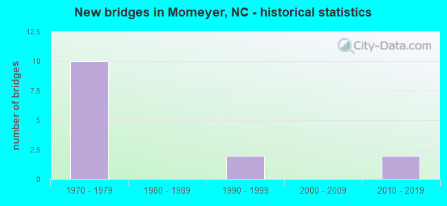
- New bridges - historical statistics
- 101970-1979
- 21990-1999
- 22010-2019


- Bridge Condition - Deck
- 16.7%Very good
- 66.7%Good
- 16.7%Satisfactory

- Bridge Condition - Superstructure
- 16.7%Very good
- 66.7%Good
- 16.7%Satisfactory

- Bridge Condition - Substructure
- 16.7%Very good
- 66.7%Good
- 16.7%Satisfactory

- Bridge Condition - Channel
- 60.0%Good
- 40.0%Satisfactory

- Bridge Condition - Culverts
- 50.0%Good
- 50.0%Fair
Find on map >> Show street view
Structure Number: 1270026, Location: 0.2 MI.E.JCT.SR1919 (Lat: 35.924833, Lng: -78.047833), Route carried "on" structure: State highway 1145, Year Built: 2014, Status: Open, Structure Length: 3.71m (12.17ft), Average Daily Traffic: 650 (year 2014), Truck Traffic: 6%, Average Future Daily Traffic: 1,300 (year 2040), Design Load: HL 93, Features Intersected: SAPONY CREEK
Minimum Vertical Clearance: 30+ m (98+ ft), Kilometerpoint: 0.000, Lanes on structure: 2, Owner: State Highway Agency, Approaching Roadway Width: 8.2m (26.9ft), Material/Design: Prestressed concrete, Design/Construction: Slab, Number Of Spans In Main Unit: 2, Number Of Approach Spans: 2, Length of Maximum Span: 17.9m (58.7ft), Curb-To-Curb Width: 8.2m (26.9ft), Out-to-Out Width: 9.1m (29.9ft)
Condition: Deck: Good, Superstructure: Good, Substructure: Very good, Channel: Good, Operating Rating: 89.8 metric tons, Method Used To Determine Operating Rating: Load and Resistance Factor (LRFR), Inventory Rating: 81.6 metric tons, Method Used To Determine Inventory Rating: Load and Resistance Factor (LRFR), Structural Evaluation: Better than present minimum criteria, Deck Geometry: Somewhat better than minimum adequacy, Waterway Adequacy: Better than present minimum criteria, Approach Roadway Alignment: Equal to present desirable criteria, Designated Inspection Frequency: Every 24 months, Underwater Inspection Frequency: Every 60 months, Inspection Date: August 2020, Underwater Inspection Date: June 2019, Deck Structure Type: Concrete Precast Panels, Wearing Surface/Protective System: Wearing Surface: Bituminous, Deck Protection: Epoxy Coated Reinforcing
Find on map >> Show street view
Structure Number: 1270049, Location: 1.4 MI.E. JCT.NC581 (Lat: 35.932503, Lng: -78.071669), Route carried "on" structure: US 64, Year Built: 1978, Status: Open, Structure Length: 0.97m (3.18ft), Average Daily Traffic: 21,000 (year 2012), Truck Traffic: 14%, Average Future Daily Traffic: 42,000 (year 2040), Design Load: HS 20+Mod, Features Intersected: SAPONY CREEK
Minimum Vertical Clearance: 30+ m (98+ ft), Kilometerpoint: 137.771, Lanes on structure: 4, Base Highway Network: Yes (Inventory Route: 2, Subroute: 64), Owner: State Highway Agency, Approaching Roadway Width: 19.5m (64.0ft), Skew: 1 degrees, Material/Design: Concrete continuous, Design/Construction: Culvert, Number Of Spans In Main Unit: 3, Length of Maximum Span: 3.0m (9.8ft)
Condition: Channel: Good, Culverts: Fair, Operating Rating: 51.7 metric tons, Method Used To Determine Operating Rating: Load and Resistance Factor (LRFR), Inventory Rating: 39.9 metric tons, Method Used To Determine Inventory Rating: Load and Resistance Factor (LRFR), Structural Evaluation: Somewhat better than minimum adequacy, Waterway Adequacy: Equal to present minimum criteria, Approach Roadway Alignment: Equal to present desirable criteria, Designated Inspection Frequency: Every 24 months, Inspection Date: April 2020
Find on map >> Show street view
Structure Number: 1270057, Location: 0.4 MI.S JCT SR 1915 (Lat: 35.940119, Lng: -78.053836), Route carried "on" structure: State highway 1306, Year Built: 1976, Status: Open, Structure Length: 7.40m (24.28ft), Average Daily Traffic: 1,500 (year 2017), Truck Traffic: 6%, Average Future Daily Traffic: 3,000 (year 2040), Design Load: HS 15, Features Intersected: US64
Minimum Vertical Clearance: 30+ m (98+ ft), Kilometerpoint: 0.000, Lanes on structure: 2, Lanes under structure: 4, Owner: State Highway Agency, Approaching Roadway Width: 15.2m (49.9ft), Skew: 1 degrees, Material/Design: Steel continuous, Design/Construction: Stringer/Multi-beam, Number Of Spans In Main Unit: 2, Length of Maximum Span: 35.9m (117.8ft), Curb-To-Curb Width: 18.0m (59.1ft), Out-to-Out Width: 18.8m (61.7ft)
Condition: Deck: Satisfactory, Superstructure: Satisfactory, Substructure: Good, Operating Rating: 82.5 metric tons, Method Used To Determine Operating Rating: Load Factor (LF), Inventory Rating: 49.8 metric tons, Method Used To Determine Inventory Rating: Load Factor (LF), Structural Evaluation: Equal to present minimum criteria, Deck Geometry: Superior to present desirable criteria, Underclear: Equal to present minimum criteria, Approach Roadway Alignment: Equal to present desirable criteria, Designated Inspection Frequency: Every 24 months, Inspection Date: April 2020, Deck Structure Type: Concrete Cast-file-Place, Wearing Surface/Protective System: Wearing Surface: Monolithic Concrete
Find on map >> Show street view
Structure Number: 1270061, Location: 0.8 MI. E. OF SR1306 (Lat: 35.944933, Lng: -78.041725), Route carried "on" structure: State highway 1911, Year Built: 1976, Status: Open, Structure Length: 7.68m (25.20ft), Average Daily Traffic: 130 (year 2000), Truck Traffic: 6%, Average Future Daily Traffic: 260 (year 2040), Design Load: HS 15, Features Intersected: US64
Minimum Vertical Clearance: 30+ m (98+ ft), Kilometerpoint: 0.000, Lanes on structure: 2, Lanes under structure: 4, Owner: State Highway Agency, Approaching Roadway Width: 5.7m (18.7ft), Skew: 2 degrees, Material/Design: Steel, Design/Construction: Stringer/Multi-beam, Number Of Spans In Main Unit: 2, Length of Maximum Span: 37.7m (123.7ft), Curb or Sidewalk Widths: Left: 0.1m (0.3ft), Right: 0.1m (0.3ft), Curb-To-Curb Width: 8.9m (29.2ft), Out-to-Out Width: 9.7m (31.8ft)
Condition: Deck: Good, Superstructure: Good, Substructure: Good, Operating Rating: 86.1 metric tons, Method Used To Determine Operating Rating: Load Factor (LF), Inventory Rating: 51.7 metric tons, Method Used To Determine Inventory Rating: Load Factor (LF), Structural Evaluation: Better than present minimum criteria, Deck Geometry: Equal to present minimum criteria, Underclear: Equal to present minimum criteria, Approach Roadway Alignment: Equal to present desirable criteria, Designated Inspection Frequency: Every 24 months, Inspection Date: August 2020, Deck Structure Type: Concrete Cast-file-Place, Wearing Surface/Protective System: Wearing Surface: Monolithic Concrete, Deck Protection: Epoxy Coated Reinforcing
Find on map >> Show street view
Structure Number: 1270063, Location: 0.2 MI.N. OF JCT SR1900 (Lat: 35.950717, Lng: -78.017925), Route carried "on" structure: State highway 1909, Year Built: 1977, Status: Open, Structure Length: 7.95m (26.08ft), Average Daily Traffic: 210 (year 2013), Truck Traffic: 6%, Average Future Daily Traffic: 420 (year 2040), Design Load: HS 15, Features Intersected: US64
Minimum Vertical Clearance: 30+ m (98+ ft), Kilometerpoint: 0.000, Lanes on structure: 2, Lanes under structure: 4, Owner: State Highway Agency, Approaching Roadway Width: 6.0m (19.7ft), Skew: 1 degrees, Material/Design: Steel, Design/Construction: Stringer/Multi-beam, Number Of Spans In Main Unit: 2, Length of Maximum Span: 39.3m (128.9ft), Curb-To-Curb Width: 8.9m (29.2ft), Out-to-Out Width: 9.7m (31.8ft)
Condition: Deck: Good, Superstructure: Good, Substructure: Satisfactory, Operating Rating: 88.9 metric tons, Method Used To Determine Operating Rating: Load Factor (LF), Inventory Rating: 53.5 metric tons, Method Used To Determine Inventory Rating: Load Factor (LF), Structural Evaluation: Equal to present minimum criteria, Deck Geometry: Equal to present minimum criteria, Underclear: Equal to present minimum criteria, Approach Roadway Alignment: Equal to present desirable criteria, Designated Inspection Frequency: Every 24 months, Inspection Date: August 2020, Deck Structure Type: Concrete Cast-file-Place, Wearing Surface/Protective System: Wearing Surface: Monolithic Concrete
Find on map >> Show street view
Structure Number: 1270083, Location: 0.7 MI.N. JCT. SR1300 (Lat: 35.994111, Lng: -78.080447), Route carried "on" structure: State highway 1305, Year Built: 2015, Status: Open, Structure Length: 2.74m (8.99ft), Average Daily Traffic: 280 (year 2016), Truck Traffic: 6%, Average Future Daily Traffic: 560 (year 2040), Design Load: HL 93, Features Intersected: LITTLE PEACHTREE CREEK
Minimum Vertical Clearance: 30+ m (98+ ft), Kilometerpoint: 0.000, Lanes on structure: 2, Owner: State Highway Agency, Approaching Roadway Width: 8.2m (26.9ft), Material/Design: Prestressed concrete, Design/Construction: Slab, Number Of Spans In Main Unit: 2, Length of Maximum Span: 17.6m (57.7ft), Curb-To-Curb Width: 8.3m (27.2ft), Out-to-Out Width: 9.1m (29.9ft)
Condition: Deck: Good, Superstructure: Good, Substructure: Good, Channel: Satisfactory, Operating Rating: 49.8 metric tons, Method Used To Determine Operating Rating: Load and Resistance Factor (LRFR), Inventory Rating: 38.1 metric tons, Method Used To Determine Inventory Rating: Load and Resistance Factor (LRFR), Structural Evaluation: Better than present minimum criteria, Deck Geometry: Somewhat better than minimum adequacy, Waterway Adequacy: Better than present minimum criteria, Approach Roadway Alignment: Equal to present desirable criteria, Designated Inspection Frequency: Every 24 months, Underwater Inspection Frequency: Every 60 months, Inspection Date: July 2021, Underwater Inspection Date: September 2020, Deck Structure Type: Concrete Precast Panels, Wearing Surface/Protective System: Wearing Surface: Bituminous, Deck Protection: Epoxy Coated Reinforcing
Find on map >> Show street view
Structure Number: 1270088, Location: 0.8 MI W. OF JCT SR1300 (Lat: 36.000475, Lng: -78.067744), Route carried "on" structure: State highway 1308, Year Built: 1999, Status: Open, Structure Length: 3.56m (11.68ft), Average Daily Traffic: 250 (year 2018), Truck Traffic: 6%, Average Future Daily Traffic: 500 (year 2040), Design Load: HS 20+Mod, Features Intersected: LITTLE PEACHTREE CR.
Minimum Vertical Clearance: 30+ m (98+ ft), Kilometerpoint: 0.000, Lanes on structure: 2, Owner: State Highway Agency, Approaching Roadway Width: 6.7m (22.0ft), Material/Design: Prestressed concrete, Design/Construction: Slab, Number Of Spans In Main Unit: 3, Length of Maximum Span: 14.9m (48.9ft), Curb-To-Curb Width: 9.1m (29.9ft), Out-to-Out Width: 10.0m (32.8ft)
Condition: Deck: Very good, Superstructure: Very good, Substructure: Good, Channel: Good, Operating Rating: 80.7 metric tons, Method Used To Determine Operating Rating: Load Factor (LF), Inventory Rating: 48.0 metric tons, Method Used To Determine Inventory Rating: Load Factor (LF), Structural Evaluation: Better than present minimum criteria, Deck Geometry: Equal to present minimum criteria, Waterway Adequacy: Better than present minimum criteria, Approach Roadway Alignment: Equal to present minimum criteria, Designated Inspection Frequency: Every 24 months, Inspection Date: April 2020, Deck Structure Type: Concrete Precast Panels, Wearing Surface/Protective System: Wearing Surface: Bituminous
Find on map >> Show street view
Structure Number: 1270323, Location: 0.6 MI. N. JCT. SR1912 (Lat: 35.944281, Lng: -78.021983), Route carried "on" structure: State highway 1900, Year Built: 1998, Status: Open, Structure Length: 0.73m (2.40ft), Average Daily Traffic: 310 (year 2017), Truck Traffic: 6%, Average Future Daily Traffic: 620 (year 2040), Design Load: HS 20+Mod, Features Intersected: CREEK
Minimum Vertical Clearance: 30+ m (98+ ft), Kilometerpoint: 0.000, Lanes on structure: 2, Owner: State Highway Agency, Approaching Roadway Width: 5.7m (18.7ft), Skew: 1 degrees, Material/Design: Steel, Design/Construction: Culvert, Number Of Spans In Main Unit: 2, Length of Maximum Span: 3.0m (9.8ft)
Condition: Channel: Satisfactory, Culverts: Good, Operating Rating: 89.8 metric tons, Method Used To Determine Operating Rating: Load and Resistance Factor (LRFR), Inventory Rating: 89.8 metric tons, Method Used To Determine Inventory Rating: Load and Resistance Factor (LRFR), Structural Evaluation: Better than present minimum criteria, Waterway Adequacy: Better than present minimum criteria, Approach Roadway Alignment: Equal to present desirable criteria, Designated Inspection Frequency: Every 24 months, Inspection Date: May 2020
Find on map >> Show street view
Structure Number: 1270057, Location: 0.4 MI.S JCT SR 1915 (Lat: 35.940119, Lng: -78.053836), Route carried "under" structure: US 64, Year Built: 1976, Structure Length: 0. m, Average Daily Traffic: 1,100 (year 2015), Truck Traffic: 12%, Features Intersected: SR1306
Minimum Vertical Clearance: 5.30m (17.39ft), Kilometerpoint: 138.106, Lanes on structure: 2, Lanes under structure: 2, Material/Design: Steel continuous, Design/Construction: Stringer/Multi-beam, Length of Maximum Span: 35.9m (117.8ft)
Find on map >> Show street view
Structure Number: 1270057, Location: 0.4 MI.S JCT SR 1915 (Lat: 35.940119, Lng: -78.053836), Route carried "under" structure: US 64, Year Built: 1976, Structure Length: 0. m, Average Daily Traffic: 12,000 (year 2017), Truck Traffic: 12%, Features Intersected: SR1306
Minimum Vertical Clearance: 5.23m (17.16ft), Kilometerpoint: 138.106, Lanes on structure: 2, Lanes under structure: 2, Material/Design: Steel continuous, Design/Construction: Stringer/Multi-beam, Length of Maximum Span: 35.9m (117.8ft)
Find on map >> Show street view
Structure Number: 1270061, Location: 0.8 MI. E. OF SR1306 (Lat: 35.944933, Lng: -78.041725), Route carried "under" structure: US 64, Year Built: 1976, Structure Length: 0. m, Average Daily Traffic: 11,500 (year 2013), Truck Traffic: 14%, Features Intersected: SR1911
Minimum Vertical Clearance: 5.02m (16.47ft), Kilometerpoint: 138.350, Lanes on structure: 2, Lanes under structure: 2, Material/Design: Steel, Design/Construction: Stringer/Multi-beam, Length of Maximum Span: 37.7m (123.7ft)
Find on map >> Show street view
Structure Number: 1270061, Location: 0.8 MI. E. OF SR1306 (Lat: 35.944933, Lng: -78.041725), Route carried "under" structure: US 64, Year Built: 1976, Structure Length: 0. m, Average Daily Traffic: 11,500 (year 2013), Truck Traffic: 14%, Features Intersected: SR1911
Minimum Vertical Clearance: 5.58m (18.31ft), Kilometerpoint: 138.350, Lanes on structure: 2, Lanes under structure: 2, Material/Design: Steel, Design/Construction: Stringer/Multi-beam, Length of Maximum Span: 37.7m (123.7ft)
Find on map >> Show street view
Structure Number: 1270063, Location: 0.2 MI.N. OF JCT SR1900 (Lat: 35.950717, Lng: -78.017925), Route carried "under" structure: US 64, Year Built: 1977, Structure Length: 0. m, Average Daily Traffic: 11,500 (year 2013), Truck Traffic: 14%, Features Intersected: SR1909
Minimum Vertical Clearance: 5.13m (16.83ft), Kilometerpoint: 138.807, Lanes on structure: 2, Lanes under structure: 2, Material/Design: Steel, Design/Construction: Stringer/Multi-beam, Length of Maximum Span: 39.3m (128.9ft)
Find on map >> Show street view
Structure Number: 1270063, Location: 0.2 MI.N. OF JCT SR1900 (Lat: 35.950717, Lng: -78.017925), Route carried "under" structure: US 64, Year Built: 1977, Structure Length: 0. m, Average Daily Traffic: 11,500 (year 2013), Truck Traffic: 14%, Features Intersected: SR1909
Minimum Vertical Clearance: 5.07m (16.63ft), Kilometerpoint: 138.807, Lanes on structure: 2, Lanes under structure: 2, Material/Design: Steel, Design/Construction: Stringer/Multi-beam, Length of Maximum Span: 39.3m (128.9ft)