Bridge Statistics for Mont Belvieu, Texas (TX)
Condition, Traffic, Stress, Structural Evaluation, Project Costs
- National Bridge Inventory (NBI) Statistics
- 17Number of bridges
- 446ft / 136mTotal length
- $574,000Total costs
- 321,463Total average daily traffic
- 58,402Total average daily truck traffic
- National Bridge Inventory (NBI) Registered Bridges for Mont Belvieu
- No street view available for this location
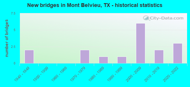
- New bridges - historical statistics
- 21940-1949
- 21970-1979
- 11980-1989
- 11990-1999
- 62000-2009
- 22010-2019
- 32020-2022


- Bridge Condition - Deck
- 10.0%Very good
- 70.0%Good
- 20.0%Satisfactory

- Bridge Condition - Superstructure
- 50.0%Very good
- 40.0%Good
- 10.0%Satisfactory

- Bridge Condition - Substructure
- 20.0%Very good
- 80.0%Good

- Bridge Condition - Channel
- 28.6%Very good
- 50.0%Good
- 21.4%Satisfactory

- Bridge Condition - Culverts
- 20.0%Very good
- 80.0%Good
Find on map >> Show street view
Structure Number: 200360038902027, Location: 0.4 MI N OF IH 10 (Lat: 29.826608, Lng: -94.897703), Route carried "on" structure: State highway 146, Year Built: 1943, Year Reconstructed: 1990, Status: Open, Structure Length: 2.74m (8.99ft), Average Daily Traffic: 30,259 (year 2020), Truck Traffic: 13%, Average Future Daily Traffic: 18,010 (year 2033), Design Load: H 15, Features Intersected: SMITHS GULLY
Minimum Vertical Clearance: 30+ m (98+ ft), Kilometerpoint: 6.626, Lanes on structure: 5, Owner: State Highway Agency, Approaching Roadway Width: 23.8m (78.1ft), Material/Design: Concrete, Design/Construction: Tee Beam, Number Of Spans In Main Unit: 3, Length of Maximum Span: 9.1m (29.9ft), Curb-To-Curb Width: 25.1m (82.3ft), Out-to-Out Width: 25.6m (84.0ft)
Condition: Deck: Good, Superstructure: Good, Substructure: Good, Channel: Good, Operating Rating: 67.1 metric tons, Method Used To Determine Operating Rating: Load Factor (LF), Inventory Rating: 39.9 metric tons, Method Used To Determine Inventory Rating: Load Factor (LF), Structural Evaluation: Better than present minimum criteria, Deck Geometry: Superior to present desirable criteria, Waterway Adequacy: Superior to present desirable criteria, Approach Roadway Alignment: Equal to present desirable criteria, Designated Inspection Frequency: Every 24 months, Inspection Date: June 2020, Deck Structure Type: Concrete Cast-file-Place
Find on map >> Show street view
Structure Number: 20036003890203, Location: 3.7 MI N OF IH 10 (Lat: 29.874231, Lng: -94.893617), Route carried "on" structure: State highway 146, Year Built: 1990, Status: Open, Structure Length: 0.91m (2.99ft), Average Daily Traffic: 15,373 (year 2020), Truck Traffic: 13%, Average Future Daily Traffic: 17,360 (year 2033), Design Load: HS 20, Features Intersected: DRAW
Minimum Vertical Clearance: 30+ m (98+ ft), Kilometerpoint: 1.122, Lanes on structure: 5, Owner: State Highway Agency, Approaching Roadway Width: 23.8m (78.1ft), Material/Design: Concrete, Design/Construction: Culvert, Number Of Spans In Main Unit: 4, Length of Maximum Span: 1.8m (5.9ft)
Condition: Channel: Satisfactory, Culverts: Good, Operating Rating: 39.9 metric tons, Method Used To Determine Operating Rating: Load Factor (LF), Inventory Rating: 23.6 metric tons, Method Used To Determine Inventory Rating: Load Factor (LF), Structural Evaluation: Somewhat better than minimum adequacy, Waterway Adequacy: Equal to present minimum criteria, Approach Roadway Alignment: Equal to present desirable criteria, Designated Inspection Frequency: Every 48 months, Inspection Date: June 2020
Find on map >> Show street view
Structure Number: 200360038902031, Location: 3.2 MI N OF IH 10 (Lat: 29.866844, Lng: -94.893378), Route carried "on" structure: State highway 146, Year Built: 1944, Year Reconstructed: 1990, Status: Open, Structure Length: 1.43m (4.69ft), Average Daily Traffic: 15,373 (year 2020), Truck Traffic: 13%, Average Future Daily Traffic: 17,360 (year 2033), Design Load: H 15, Features Intersected: IRRIGATION CANAL
Minimum Vertical Clearance: 30+ m (98+ ft), Kilometerpoint: 2.110, Lanes on structure: 5, Owner: State Highway Agency, Approaching Roadway Width: 23.8m (78.1ft), Skew: 9 degrees, Material/Design: Concrete, Design/Construction: Culvert, Number Of Spans In Main Unit: 7, Length of Maximum Span: 1.8m (5.9ft)
Condition: Channel: Good, Culverts: Good, Operating Rating: 39.9 metric tons, Method Used To Determine Operating Rating: Load Factor (LF), Inventory Rating: 23.6 metric tons, Method Used To Determine Inventory Rating: Load Factor (LF), Structural Evaluation: Somewhat better than minimum adequacy, Waterway Adequacy: Equal to present minimum criteria, Approach Roadway Alignment: Equal to present desirable criteria, Designated Inspection Frequency: Every 24 months, Inspection Date: June 2020
Find on map >> Show street view
Structure Number: 200360050802338, Location: 0.2 MI E OF FM 3180 (Lat: 29.826461, Lng: -94.842828), Route carried "on" structure: Interstate 10, Year Built: 2000, Status: Open, Structure Length: 2.74m (8.99ft), Average Daily Traffic: 65,039 (year 2020), Truck Traffic: 20%, Average Future Daily Traffic: 85,080 (year 2033), Design Load: HS 20, Features Intersected: COTTON BAYOU
Minimum Vertical Clearance: 30+ m (98+ ft), Kilometerpoint: 6.560, Lanes on structure: 6, Owner: State Highway Agency, Approaching Roadway Width: 34.1m (111.9ft), Skew: 30 degrees, Material/Design: Prestressed concrete, Design/Construction: Stringer/Multi-beam, Number Of Spans In Main Unit: 3, Length of Maximum Span: 9.1m (29.9ft), Curb-To-Curb Width: 34.4m (112.9ft), Out-to-Out Width: 36.0m (118.1ft)
Condition: Deck: Good, Superstructure: Good, Substructure: Good, Channel: Good, Operating Rating: 54.4 metric tons, Method Used To Determine Operating Rating: Assigned rating based on Load Factor Design (LFD) reported in metric tons, Inventory Rating: 32.7 metric tons, Method Used To Determine Inventory Rating: Assigned rating based on Load Factor Design (LFD) reported in metric tons, Structural Evaluation: Better than present minimum criteria, Deck Geometry: Superior to present desirable criteria, Waterway Adequacy: Superior to present desirable criteria, Approach Roadway Alignment: Equal to present desirable criteria, Length Of Structure Improvement: 3.54m (11.61ft), Designated Inspection Frequency: Every 24 months, Inspection Date: June 2020, Bridge Improvement Cost: $459,000, Roadway Improvement Cost: $115,000, Total Project Cost: $574,000, Deck Structure Type: Concrete Cast-file-Place
Find on map >> Show street view
Structure Number: 200360050802349, Location: 2.0 MI E OF SH 146 (Lat: 29.824553, Lng: -94.864856), Route carried "on" structure: Interstate 10, Year Built: 2007, Status: Open, Structure Length: 53.80m (176.51ft), Average Daily Traffic: 65,039 (year 2020), Truck Traffic: 20%, Average Future Daily Traffic: 85,080 (year 2033), Design Load: HS 20, Features Intersected: SH 99 & HACKBERRY GULLY
Minimum Vertical Clearance: 30+ m (98+ ft), Kilometerpoint: 3.983, Lanes on structure: 6, Lanes under structure: 7, Owner: State Highway Agency, Approaching Roadway Width: 34.7m (113.8ft), Skew: 39 degrees, Material/Design: Prestressed concrete, Design/Construction: Stringer/Multi-beam, Number Of Spans In Main Unit: 15, Number Of Approach Spans: 1, Length of Maximum Span: 35.1m (115.2ft), Curb-To-Curb Width: 37.1m (121.7ft), Out-to-Out Width: 38.6m (126.6ft)
Condition: Deck: Satisfactory, Superstructure: Good, Substructure: Good, Channel: Good, Operating Rating: 54.4 metric tons, Method Used To Determine Operating Rating: Assigned rating based on Load Factor Design (LFD) reported in metric tons, Inventory Rating: 32.7 metric tons, Method Used To Determine Inventory Rating: Assigned rating based on Load Factor Design (LFD) reported in metric tons, Structural Evaluation: Better than present minimum criteria, Deck Geometry: Superior to present desirable criteria, Underclear: Somewhat better than minimum adequacy, Waterway Adequacy: Superior to present desirable criteria, Approach Roadway Alignment: Equal to present desirable criteria, Designated Inspection Frequency: Every 24 months, Inspection Date: June 2020, Deck Structure Type: Concrete Precast Panels
Find on map >> Show street view
Structure Number: 20036005080235, Location: 0.1 MI E OF SH 99 (Lat: 29.824250, Lng: -94.864475), Route carried "on" structure: ServiceInterstate 10, Year Built: 2007, Status: Open, Structure Length: 3.20m (10.50ft), Average Daily Traffic: 1,650 (year 2013), Truck Traffic: 21%, Average Future Daily Traffic: 2,310 (year 2033), Design Load: HS 20, Features Intersected: HACKBERRY GULLY
Minimum Vertical Clearance: 30+ m (98+ ft), Kilometerpoint: 4.450, Lanes on structure: 3, Owner: State Highway Agency, Approaching Roadway Width: 11.6m (38.1ft), Material/Design: Prestressed concrete, Number Of Spans In Main Unit: 3, Length of Maximum Span: 10.7m (35.1ft), Curb-To-Curb Width: 14.6m (47.9ft), Out-to-Out Width: 15.5m (50.9ft)
Condition: Deck: Good, Superstructure: Very good, Substructure: Good, Channel: Good, Operating Rating: 54.4 metric tons, Method Used To Determine Operating Rating: Assigned rating based on Load Factor Design (LFD) reported in metric tons, Inventory Rating: 32.7 metric tons, Method Used To Determine Inventory Rating: Assigned rating based on Load Factor Design (LFD) reported in metric tons, Structural Evaluation: Better than present minimum criteria, Deck Geometry: Somewhat better than minimum adequacy, Waterway Adequacy: Superior to present desirable criteria, Approach Roadway Alignment: Equal to present desirable criteria, Designated Inspection Frequency: Every 24 months, Inspection Date: June 2020, Deck Structure Type: Concrete Cast-file-Place
Find on map >> Show street view
Structure Number: 200360050802351, Location: 0.1 MI E OF SH 99 (Lat: 29.824883, Lng: -94.864544), Route carried "on" structure: ServiceInterstate 10, Year Built: 2004, Status: Open, Structure Length: 3.20m (10.50ft), Average Daily Traffic: 1,580 (year 2013), Truck Traffic: 21%, Average Future Daily Traffic: 2,210 (year 2033), Design Load: HS 20, Features Intersected: HACKBERRY GULLY
Minimum Vertical Clearance: 30+ m (98+ ft), Kilometerpoint: 4.450, Lanes on structure: 2, Owner: State Highway Agency, Approaching Roadway Width: 14.0m (45.9ft), Material/Design: Prestressed concrete, Number Of Spans In Main Unit: 3, Length of Maximum Span: 10.7m (35.1ft), Curb-To-Curb Width: 14.0m (45.9ft), Out-to-Out Width: 14.9m (48.9ft)
Condition: Deck: Good, Superstructure: Very good, Substructure: Good, Channel: Good, Operating Rating: 54.4 metric tons, Method Used To Determine Operating Rating: Assigned rating based on Load Factor Design (LFD) reported in metric tons, Inventory Rating: 32.7 metric tons, Method Used To Determine Inventory Rating: Assigned rating based on Load Factor Design (LFD) reported in metric tons, Structural Evaluation: Better than present minimum criteria, Deck Geometry: Superior to present desirable criteria, Waterway Adequacy: Superior to present desirable criteria, Approach Roadway Alignment: Equal to present desirable criteria, Designated Inspection Frequency: Every 24 months, Inspection Date: June 2020, Deck Structure Type: Concrete Cast-file-Place
Find on map >> Show street view
Structure Number: 200360050802472, Location: 0.2 MI E OF FM 3180 (Lat: 29.826767, Lng: -94.842853), Route carried "on" structure: ServiceInterstate 10, Year Built: 2011, Status: Open, Structure Length: 2.59m (8.50ft), Average Daily Traffic: 1,650 (year 2013), Truck Traffic: 21%, Average Future Daily Traffic: 2,310 (year 2033), Design Load: HL 93, Features Intersected: COTTON BAYOU
Minimum Vertical Clearance: 30+ m (98+ ft), Kilometerpoint: 6.560, Lanes on structure: 2, Owner: State Highway Agency, Approaching Roadway Width: 7.3m (24.0ft), Material/Design: Prestressed concrete, Number Of Spans In Main Unit: 1, Number Of Approach Spans: 2, Length of Maximum Span: 10.7m (35.1ft), Curb-To-Curb Width: 10.6m (34.8ft), Out-to-Out Width: 11.6m (38.1ft)
Condition: Deck: Good, Superstructure: Very good, Substructure: Very good, Channel: Very good, Operating Rating: 54.4 metric tons, Method Used To Determine Operating Rating: Assigned ratings based on Load and Resistance Factor Design (LRFD) reported in metric tons, Inventory Rating: 32.7 metric tons, Method Used To Determine Inventory Rating: Assigned ratings based on Load and Resistance Factor Design (LRFD) reported in metric tons, Structural Evaluation: Equal to present desirable criteria, Deck Geometry: Somewhat better than minimum adequacy, Waterway Adequacy: Superior to present desirable criteria, Approach Roadway Alignment: Equal to present desirable criteria, Designated Inspection Frequency: Every 24 months, Inspection Date: June 2020, Deck Structure Type: Concrete Cast-file-Place
Find on map >> Show street view
Structure Number: 200360050802484, Location: IH 10 @ FM 3180 (Lat: 29.826108, Lng: -94.846681), Route carried "on" structure: Interstate 10, Year Built: 2020, Status: Open, Structure Length: 51.21m (168.01ft), Average Daily Traffic: 79,300 (year 2020), Truck Traffic: 23%, Average Future Daily Traffic: 108,600 (year 2038), Design Load: HL 93, Features Intersected: FM 3180
Minimum Vertical Clearance: 30+ m (98+ ft), Kilometerpoint: 8.830, Lanes on structure: 6, Lanes under structure: 2, Base Highway Network: Yes, Owner: State Highway Agency, Approaching Roadway Width: 35.4m (116.1ft), Material/Design: Prestressed concrete, Design/Construction: Stringer/Multi-beam, Number Of Spans In Main Unit: 2, Number Of Approach Spans: 13, Length of Maximum Span: 38.1m (125.0ft), Curb-To-Curb Width: 17.1m (56.1ft), Out-to-Out Width: 35.4m (116.1ft)
Condition: Deck: Very good, Superstructure: Very good, Substructure: Good, Operating Rating: 54.4 metric tons, Method Used To Determine Operating Rating: Assigned ratings based on Load and Resistance Factor Design (LRFD) reported in metric tons, Inventory Rating: 54.4 metric tons, Method Used To Determine Inventory Rating: Assigned ratings based on Load and Resistance Factor Design (LRFD) reported in metric tons, Structural Evaluation: Better than present minimum criteria, Deck Geometry: High priority of replacement, Underclear: Meets minimum limits, Approach Roadway Alignment: Equal to present desirable criteria, Designated Inspection Frequency: Every 24 months, Inspection Date: October 2020, Deck Structure Type: Concrete Precast Panels
Find on map >> Show street view
Structure Number: 200360102401443, Location: 2.1 MI NORTH OF IH 10 (Lat: 29.858528, Lng: -94.815581), Route carried "on" structure: State highway 565, Year Built: 2020, Status: Open, Structure Length: 0.82m (2.69ft), Average Daily Traffic: 200 (year 2019), Truck Traffic: 3%, Average Future Daily Traffic: 400 (year 2039), Design Load: HL 93, Features Intersected: TRIB OLD RIVER
Minimum Vertical Clearance: 30+ m (98+ ft), Kilometerpoint: 3.380, Lanes on structure: 2, Owner: State Highway Agency, Approaching Roadway Width: 9.1m (29.9ft), Material/Design: Concrete, Design/Construction: Culvert, Number Of Spans In Main Unit: 2, Length of Maximum Span: 2.7m (8.9ft), Curb-To-Curb Width: 8.8m (28.9ft), Out-to-Out Width: 17.7m (58.1ft)
Condition: Channel: Very good, Culverts: Very good, Operating Rating: 54.4 metric tons, Method Used To Determine Operating Rating: Assigned ratings based on Load and Resistance Factor Design (LRFD) reported in metric tons, Inventory Rating: 32.7 metric tons, Method Used To Determine Inventory Rating: Assigned ratings based on Load and Resistance Factor Design (LRFD) reported in metric tons, Structural Evaluation: Equal to present desirable criteria, Deck Geometry: Equal to present minimum criteria, Waterway Adequacy: Better than present minimum criteria, Approach Roadway Alignment: Meets minimum limits, Designated Inspection Frequency: Every 24 months, Inspection Date: April 2021
Find on map >> Show street view
Structure Number: 200360AA0101001, Location: 2.35 MI N OF FM 1942 (Lat: 29.879967, Lng: -94.930467), Route carried "on" structure: County highway , Year Built: 1976, Status: Open, Structure Length: 3.20m (10.50ft), Average Daily Traffic: 1,222 (year 2016), Average Future Daily Traffic: 235 (year 2035), Features Intersected: LYNCHBURG CANAL, Facility Carried by Structure: HATCHERVILLE RD
Minimum Vertical Clearance: 30+ m (98+ ft), Kilometerpoint: 3.541, Lanes on structure: 2, Owner: County Highway Agency, Approaching Roadway Width: 6.1m (20.0ft), Skew: 1 degrees, Material/Design: Concrete, Design/Construction: Stringer/Multi-beam, Number Of Spans In Main Unit: 3, Length of Maximum Span: 12.5m (41.0ft), Curb-To-Curb Width: 9.2m (30.2ft), Out-to-Out Width: 9.9m (32.5ft)
Condition: Deck: Good, Superstructure: Good, Substructure: Good, Channel: Satisfactory, Operating Rating: 32.7 metric tons, Method Used To Determine Operating Rating: Field evaluation and documented engineering judgment, Inventory Rating: 24.5 metric tons, Method Used To Determine Inventory Rating: Field evaluation and documented engineering judgment, Structural Evaluation: Equal to present minimum criteria, Deck Geometry: Somewhat better than minimum adequacy, Waterway Adequacy: Better than present minimum criteria, Approach Roadway Alignment: Equal to present desirable criteria, Designated Inspection Frequency: Every 24 months, Inspection Date: April 2021, Deck Structure Type: Concrete Cast-file-Place
Find on map >> Show street view
Structure Number: 200360C00050001, Location: 0.3 MI E OF SH 146 (Lat: 29.876011, Lng: -94.889728), Route carried "on" structure: City street , Year Built: 1986, Status: Open, Structure Length: 0.96m (3.15ft), Average Daily Traffic: 3,340 (year 2013), Truck Traffic: 3%, Average Future Daily Traffic: 4,680 (year 2033), Design Load: HS 20, Features Intersected: DRAIN, Facility Carried by Structure: Eagle Dr
Minimum Vertical Clearance: 30+ m (98+ ft), Kilometerpoint: 0.454, Lanes on structure: 2, Owner: City or Municipal Highway Agency, Approaching Roadway Width: 8.2m (26.9ft), Skew: 4 degrees, Material/Design: Concrete, Design/Construction: Culvert, Number Of Spans In Main Unit: 3, Length of Maximum Span: 2.1m (6.9ft)
Condition: Channel: Very good, Culverts: Good, Operating Rating: 39.9 metric tons, Method Used To Determine Operating Rating: Load Factor (LF), Inventory Rating: 23.6 metric tons, Method Used To Determine Inventory Rating: Load Factor (LF), Structural Evaluation: Equal to present minimum criteria, Waterway Adequacy: Equal to present minimum criteria, Approach Roadway Alignment: Equal to present desirable criteria, Designated Inspection Frequency: Every 24 months, Inspection Date: April 2021
Find on map >> Show street view
Structure Number: 201460038901069, Location: 0.7 MI N OF CHAMBERS C/L (Lat: 29.897189, Lng: -94.896439), Route carried "on" structure: State highway 146, Year Built: 1972, Status: Open, Structure Length: 3.84m (12.60ft), Average Daily Traffic: 5,810 (year 2020), Truck Traffic: 7%, Average Future Daily Traffic: 7,120 (year 2033), Design Load: HS 20, Features Intersected: CWA (Lynchburg) CANAL
Minimum Vertical Clearance: 30+ m (98+ ft), Kilometerpoint: 16.480, Lanes on structure: 2, Owner: State Highway Agency, Approaching Roadway Width: 12.8m (42.0ft), Skew: 2 degrees, Material/Design: Concrete, Design/Construction: Stringer/Multi-beam, Number Of Spans In Main Unit: 3, Length of Maximum Span: 12.8m (42.0ft), Curb-To-Curb Width: 14.6m (47.9ft), Out-to-Out Width: 15.3m (50.2ft)
Condition: Deck: Satisfactory, Superstructure: Satisfactory, Substructure: Good, Channel: Good, Operating Rating: 62.6 metric tons, Method Used To Determine Operating Rating: Load Factor (LF), Inventory Rating: 37.2 metric tons, Method Used To Determine Inventory Rating: Load Factor (LF), Structural Evaluation: Equal to present minimum criteria, Deck Geometry: Superior to present desirable criteria, Waterway Adequacy: Equal to present minimum criteria, Approach Roadway Alignment: Equal to present desirable criteria, Designated Inspection Frequency: Every 24 months, Inspection Date: April 2020, Deck Structure Type: Concrete Cast-file-Place
Find on map >> Show street view
Structure Number: 20146003890135, Location: 0.7 MI N of Chambers C/L (Lat: 29.897197, Lng: -94.895964), Route carried "on" structure: State highway 146, Year Built: 2011, Status: Open, Structure Length: 4.11m (13.48ft), Average Daily Traffic: 7,903 (year 2020), Truck Traffic: 7%, Average Future Daily Traffic: 7,120 (year 2033), Design Load: HL 93, Features Intersected: CWA (Lynchburg) Canal
Minimum Vertical Clearance: 30+ m (98+ ft), Kilometerpoint: 0.000, Lanes on structure: 2, Owner: State Highway Agency, Approaching Roadway Width: 11.6m (38.1ft), Skew: 2 degrees, Material/Design: Prestressed concrete, Design/Construction: Stringer/Multi-beam, Number Of Spans In Main Unit: 1, Length of Maximum Span: 41.1m (134.8ft), Curb-To-Curb Width: 11.6m (38.1ft), Out-to-Out Width: 12.2m (40.0ft)
Condition: Deck: Good, Superstructure: Very good, Substructure: Very good, Channel: Very good, Operating Rating: 54.4 metric tons, Method Used To Determine Operating Rating: Assigned ratings based on Load and Resistance Factor Design (LRFD) reported in metric tons, Inventory Rating: 32.7 metric tons, Method Used To Determine Inventory Rating: Assigned ratings based on Load and Resistance Factor Design (LRFD) reported in metric tons, Structural Evaluation: Equal to present desirable criteria, Deck Geometry: Better than present minimum criteria, Waterway Adequacy: Superior to present desirable criteria, Approach Roadway Alignment: Equal to present desirable criteria, Designated Inspection Frequency: Every 24 months, Inspection Date: April 2020, Deck Structure Type: Concrete Precast Panels
Find on map >> Show street view
Structure Number: 201460AA0101002, Location: 0.6 MI N CHAMBERS CO LINE (Lat: 29.893728, Lng: -94.940692), Route carried "on" structure: County highway 486, Year Built: 2008, Status: Open, Structure Length: 1.07m (3.51ft), Average Daily Traffic: 1,125 (year 2016), Truck Traffic: 3%, Average Future Daily Traffic: 1,580 (year 2037), Design Load: HS 20, Features Intersected: HICKORY ISLAND GULLY
Minimum Vertical Clearance: 30+ m (98+ ft), Kilometerpoint: 8.047, Lanes on structure: 2, Owner: County Highway Agency, Approaching Roadway Width: 8.5m (27.9ft), Skew: 3 degrees, Material/Design: Concrete, Design/Construction: Culvert, Number Of Spans In Main Unit: 4, Length of Maximum Span: 1.8m (5.9ft), Curb-To-Curb Width: 8.5m (27.9ft), Out-to-Out Width: 10.5m (34.4ft)
Condition: Channel: Satisfactory, Culverts: Good, Operating Rating: 54.4 metric tons, Method Used To Determine Operating Rating: Assigned rating based on Load Factor Design (LFD) reported in metric tons, Inventory Rating: 32.7 metric tons, Method Used To Determine Inventory Rating: Assigned rating based on Load Factor Design (LFD) reported in metric tons, Structural Evaluation: Better than present minimum criteria, Deck Geometry: Somewhat better than minimum adequacy, Waterway Adequacy: Better than present minimum criteria, Approach Roadway Alignment: Equal to present desirable criteria, Designated Inspection Frequency: Every 24 months, Inspection Date: April 2021
Find on map >> Show street view
Structure Number: 200360050802349, Location: 2.0 MI E OF SH 146 (Lat: 29.824781, Lng: -94.863811), Route carried "under" structure: ServiceState highway 99, Year Built: 2007, Structure Length: 0. m, Average Daily Traffic: 11,100 (year 2011), Truck Traffic: 9%, Features Intersected: SH 99 & HACKBERRY GULLY, Facility Carried by Structure: IH 10
Minimum Vertical Clearance: 5.33m (17.49ft), Kilometerpoint: 1.481, Lanes on structure: 6, Lanes under structure: 7, Material/Design: Prestressed concrete, Design/Construction: Stringer/Multi-beam, Length of Maximum Span: 35.1m (115.2ft)
Find on map >> Show street view
Structure Number: 200360050802484, Location: IH 10 @ FM 3180 (Lat: 29.825875, Lng: -94.846622), Route carried "under" structure: State highway 10, Year Built: 2020, Structure Length: 0. m, Average Daily Traffic: 15,500 (year 2018), Truck Traffic: 20%, Features Intersected: FM 3180
Minimum Vertical Clearance: 4.72m (15.49ft), Kilometerpoint: 8.879, Lanes on structure: 6, Lanes under structure: 2, Material/Design: Prestressed concrete, Design/Construction: Stringer/Multi-beam, Length of Maximum Span: 38.1m (125.0ft)