Bridge Statistics for Montgomery, West Virginia (WV)
Condition, Traffic, Stress, Structural Evaluation, Project Costs
- National Bridge Inventory (NBI) Statistics
- 12Number of bridges
- 285ft / 87.2mTotal length
- $14,549,000Total costs
- 129,949Total average daily traffic
- 8,403Total average daily truck traffic
- National Bridge Inventory (NBI) Registered Bridges for Montgomery
- No street view available for this location
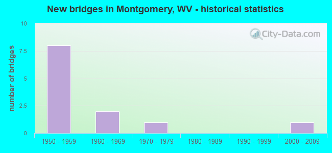
- New bridges - historical statistics
- 81950-1959
- 21960-1969
- 11970-1979
- 12000-2009


- Bridge Condition - Deck
- 57.1%Satisfactory
- 28.6%Fair
- 14.3%Poor

- Bridge Condition - Superstructure
- 14.3%Good
- 71.4%Fair
- 14.3%Serious

- Bridge Condition - Substructure
- 28.6%Satisfactory
- 28.6%Fair
- 42.9%Poor

- Bridge Condition - Channel
- 25.0%Excellent
- 25.0%Very good
- 25.0%Good
- 25.0%Fair
Find on map >> Show street view
Structure Number: 10A02, Location: 0.12 Miles S. of WV 61 (Lat: 38.182469, Lng: -81.316819), Route carried "on" structure: State highway 600, Year Built: 1956, Status: Posted for load, Structure Length: 50.75m (166.50ft), Average Daily Traffic: 17,736 (year 2019), Truck Traffic: 6%, Average Future Daily Traffic: 21,638 (year 2039), Design Load: HS 20, Features Intersected: Kanawha River US60 WV61, Facility Carried by Structure: WV 6
Minimum Vertical Clearance: 5.26m (17.26ft), Kilometerpoint: 0.193, Lanes on structure: 2, Lanes under structure: 8, Owner: State Highway Agency, Approaching Roadway Width: 8.5m (27.9ft), Navigation Control: Yes ( Vertical Clearance: 18.0m (59.1ft), Horizontal Clearance: 145.7m (478.0ft)), Material/Design: Steel, Design/Construction: Truss - Thru, Number Of Spans In Main Unit: 1, Number Of Approach Spans: 14, Length of Maximum Span: 148.2m (486.2ft), Curb or Sidewalk Widths: Left: 2.3m (7.5ft), Right: 2.3m (7.5ft), Curb-To-Curb Width: 8.5m (27.9ft), Out-to-Out Width: 14.4m (47.2ft)
Condition: Deck: Satisfactory, Superstructure: Fair, Substructure: Poor, Channel: Excellent, Operating Rating: 37.2 metric tons, Method Used To Determine Operating Rating: Load Factor (LF), Inventory Rating: 22.7 metric tons, Method Used To Determine Inventory Rating: Load Factor (LF), Structural Evaluation: Meets minimum limits, Deck Geometry: Meets minimum limits, Underclear: High priority of replacement, Waterway Adequacy: Superior to present desirable criteria, Approach Roadway Alignment: Equal to present minimum criteria, Length Of Structure Improvement: 50.75m (166.50ft), Designated Inspection Frequency: Every 24 months, Critical Feature Inspection Frequency: Every 24 months, Underwater Inspection Frequency: Every 60 months, Inspection Date: August 2021, Critical Feature Inspection Date: August 2021, Underwater Inspection Date: August 2019, Bridge Improvement Cost: $6,484,000, Roadway Improvement Cost: $1,167,000, Total Project Cost: $9,388,000 ( Estimate for 2021), Deck Structure Type: Concrete Cast-file-Place, Wearing Surface/Protective System: Wearing Surface: Monolithic Concrete
Find on map >> Show street view
Structure Number: 10A233, Location: 0.25 Miles N. of WV 61 (Lat: 38.181511, Lng: -81.317219), Route carried "on" structure: Ramp State highway 600, Year Built: 1956, Status: Posted for load, Structure Length: 7.08m (23.23ft), Average Daily Traffic: 16,536 (year 2019), Truck Traffic: 6%, Average Future Daily Traffic: 21,166 (year 2039), Design Load: H 20, Features Intersected: NO FEATURE INTERSECTED, Facility Carried by Structure: WV 6 S APP. RAMP
Minimum Vertical Clearance: 30+ m (98+ ft), Kilometerpoint: 0.402, Lanes on structure: 1, Owner: State Highway Agency, Approaching Roadway Width: 6.1m (20.0ft), Material/Design: Steel continuous, Design/Construction: Girder and Floorbeam System, Number Of Spans In Main Unit: 1, Number Of Approach Spans: 1, Length of Maximum Span: 39.1m (128.3ft), Curb or Sidewalk Widths: Left: 1.2m (3.9ft), Right: 0.0m, Curb-To-Curb Width: 5.8m (19.0ft), Out-to-Out Width: 7.9m (25.9ft)
Condition: Deck: Satisfactory, Superstructure: Fair, Substructure: Satisfactory, Operating Rating: 50.8 metric tons, Method Used To Determine Operating Rating: Load Factor (LF), Inventory Rating: 30.8 metric tons, Method Used To Determine Inventory Rating: Load Factor (LF), Structural Evaluation: Somewhat better than minimum adequacy, Deck Geometry: Meets minimum limits, Approach Roadway Alignment: Equal to present minimum criteria, Designated Inspection Frequency: Every 24 months, Critical Feature Inspection Frequency: Every 24 months, Other Special Inspection Frequency: Every 12 months, Inspection Date: September 2021, Critical Feature Inspection Date: September 2021, Other Special Inspection Date: September 2021, Deck Structure Type: Concrete Cast-file-Place, Wearing Surface/Protective System: Wearing Surface: Monolithic Concrete
Find on map >> Show street view
Structure Number: 10A234, Location: 0.25 Miles N. of WV 61 (Lat: 38.181650, Lng: -81.317350), Route carried "on" structure: Ramp State highway 600, Year Built: 1956, Status: Posted for load, Structure Length: 7.08m (23.23ft), Average Daily Traffic: 19,600 (year 2019), Truck Traffic: 6%, Average Future Daily Traffic: 23,912 (year 2039), Design Load: H 20, Features Intersected: NO FEATURE INTERSECTED, Facility Carried by Structure: WV 6 S EXIT RAMP
Minimum Vertical Clearance: 30+ m (98+ ft), Kilometerpoint: 0.402, Lanes on structure: 1, Owner: State Highway Agency, Approaching Roadway Width: 6.1m (20.0ft), Material/Design: Steel continuous, Design/Construction: Girder and Floorbeam System, Number Of Spans In Main Unit: 1, Number Of Approach Spans: 1, Length of Maximum Span: 39.1m (128.3ft), Curb or Sidewalk Widths: Left: 1.4m (4.6ft), Right: 0.0m, Curb-To-Curb Width: 5.8m (19.0ft), Out-to-Out Width: 7.9m (25.9ft)
Condition: Deck: Satisfactory, Superstructure: Fair, Substructure: Poor, Operating Rating: 54.4 metric tons, Method Used To Determine Operating Rating: Load Factor (LF), Inventory Rating: 32.7 metric tons, Method Used To Determine Inventory Rating: Load Factor (LF), Structural Evaluation: Meets minimum limits, Deck Geometry: Meets minimum limits, Approach Roadway Alignment: Meets minimum limits, Length Of Structure Improvement: 7.10m (23.29ft), Designated Inspection Frequency: Every 24 months, Critical Feature Inspection Frequency: Every 24 months, Inspection Date: September 2021, Critical Feature Inspection Date: September 2021, Bridge Improvement Cost: $594,000, Roadway Improvement Cost: $558,000, Total Project Cost: $1,356,000 ( Estimate for 2021), Deck Structure Type: Concrete Cast-file-Place, Wearing Surface/Protective System: Wearing Surface: Monolithic Concrete
Find on map >> Show street view
Structure Number: 20A177, Location: 0.10 MI S OF CR 61/11 (Lat: 38.180061, Lng: -81.334981), Route carried "on" structure: State highway 61, Year Built: 1969, Status: Open, Structure Length: 3.95m (12.96ft), Average Daily Traffic: 4,000 (year 2020), Truck Traffic: 5%, Average Future Daily Traffic: 4,280 (year 2040), Design Load: HS 20, Features Intersected: MORRIS CK & PRIVATE RD
Minimum Vertical Clearance: 30+ m (98+ ft), Kilometerpoint: 0.515, Lanes on structure: 2, Lanes under structure: 2, Owner: State Highway Agency, Approaching Roadway Width: 14.6m (47.9ft), Skew: 1 degrees, Material/Design: Steel continuous, Design/Construction: Stringer/Multi-beam, Number Of Spans In Main Unit: 2, Length of Maximum Span: 18.9m (62.0ft), Curb or Sidewalk Widths: Left: 1.5m (4.9ft), Right: 0.0m, Curb-To-Curb Width: 11.3m (37.1ft), Out-to-Out Width: 12.5m (41.0ft)
Condition: Deck: Fair, Superstructure: Good, Substructure: Satisfactory, Channel: Very good, Operating Rating: 59.9 metric tons, Method Used To Determine Operating Rating: Load Factor (LF), Inventory Rating: 36.3 metric tons, Method Used To Determine Inventory Rating: Load Factor (LF), Structural Evaluation: Equal to present minimum criteria, Deck Geometry: Somewhat better than minimum adequacy, Underclear: High priority of corrective action, Waterway Adequacy: Superior to present desirable criteria, Approach Roadway Alignment: Equal to present desirable criteria, Length Of Structure Improvement: 3.95m (12.96ft), Designated Inspection Frequency: Every 24 months, Inspection Date: December 2021, Bridge Improvement Cost: $300,000, Roadway Improvement Cost: $100,000, Total Project Cost: $400,000 ( Estimate for 2019), Deck Structure Type: Concrete Cast-file-Place, Wearing Surface/Protective System: Wearing Surface: Latex Concrete
Find on map >> Show street view
Structure Number: 20A584, Location: 0.07 Miles W. of US 60 (Lat: 38.184461, Lng: -81.316700), Route carried "on" structure: Ramp State highway 600, Year Built: 1956, Status: Posted for load, Structure Length: 7.71m (25.30ft), Average Daily Traffic: 19,900 (year 2019), Truck Traffic: 6%, Average Future Daily Traffic: 23,880 (year 2039), Design Load: HS 20, Features Intersected: NO FEATURE INTERSECTED, Facility Carried by Structure: WV 6 N. APCH. RAMP
Minimum Vertical Clearance: 30+ m (98+ ft), Kilometerpoint: 0.113, Lanes on structure: 1, Owner: State Highway Agency, Approaching Roadway Width: 7.9m (25.9ft), Material/Design: Steel continuous, Design/Construction: Stringer/Multi-beam, Number Of Spans In Main Unit: 5, Length of Maximum Span: 15.2m (49.9ft), Curb or Sidewalk Widths: Left: 1.4m (4.6ft), Right: 0.0m, Curb-To-Curb Width: 6.4m (21.0ft), Out-to-Out Width: 8.5m (27.9ft)
Condition: Deck: Satisfactory, Superstructure: Fair, Substructure: Fair, Operating Rating: 55.3 metric tons, Method Used To Determine Operating Rating: Load Factor (LF), Inventory Rating: 33.6 metric tons, Method Used To Determine Inventory Rating: Load Factor (LF), Structural Evaluation: Somewhat better than minimum adequacy, Deck Geometry: Somewhat better than minimum adequacy, Approach Roadway Alignment: Better than present minimum criteria, Length Of Structure Improvement: 7.71m (25.30ft), Designated Inspection Frequency: Every 24 months, Inspection Date: September 2021, Bridge Improvement Cost: $673,000, Roadway Improvement Cost: $626,000, Total Project Cost: $1,299,000 ( Estimate for 2021), Deck Structure Type: Concrete Cast-file-Place, Wearing Surface/Protective System: Wearing Surface: Monolithic Concrete
Find on map >> Show street view
Structure Number: 20A585, Location: 0.07 Miles S. of US 60 (Lat: 38.183781, Lng: -81.315011), Route carried "on" structure: Ramp State highway 600, Year Built: 1956, Status: Posted for load, Structure Length: 9.24m (30.31ft), Average Daily Traffic: 20,887 (year 2019), Truck Traffic: 6%, Average Future Daily Traffic: 25,482 (year 2039), Design Load: H 20, Features Intersected: NO FEATURE INTERSECTED, Facility Carried by Structure: WV 6 N. EXIT RAMP
Minimum Vertical Clearance: 30+ m (98+ ft), Kilometerpoint: 0.113, Lanes on structure: 1, Owner: State Highway Agency, Approaching Roadway Width: 8.5m (27.9ft), Material/Design: Steel continuous, Design/Construction: Stringer/Multi-beam, Number Of Spans In Main Unit: 6, Length of Maximum Span: 15.2m (49.9ft), Curb or Sidewalk Widths: Left: 0.0m, Right: 1.2m (3.9ft), Curb-To-Curb Width: 6.4m (21.0ft), Out-to-Out Width: 8.5m (27.9ft)
Condition: Deck: Fair, Superstructure: Fair, Substructure: Poor, Operating Rating: 29.9 metric tons, Method Used To Determine Operating Rating: Load Factor (LF), Inventory Rating: 18.1 metric tons, Method Used To Determine Inventory Rating: Load Factor (LF), Structural Evaluation: Meets minimum limits, Deck Geometry: Somewhat better than minimum adequacy, Approach Roadway Alignment: High priority of corrective action, Length Of Structure Improvement: 9.24m (30.31ft), Designated Inspection Frequency: Every 24 months, Inspection Date: September 2021, Bridge Improvement Cost: $747,000, Roadway Improvement Cost: $657,000, Total Project Cost: $1,656,000 ( Estimate for 2021), Deck Structure Type: Concrete Cast-file-Place, Wearing Surface/Protective System: Wearing Surface: Monolithic Concrete
Find on map >> Show street view
Structure Number: 20A795, Location: 0.03 MI S OF 61/10 (Lat: 38.169450, Lng: -81.329989), Route carried "on" structure: Other road 90222, Year Built: 1970, Status: Posted for load, Structure Length: 0.78m (2.56ft), Average Daily Traffic: 30 (year 2020), Truck Traffic: 3%, Average Future Daily Traffic: 36 (year 2040), Features Intersected: MORRIS CREEK, Facility Carried by Structure: COUNTY RT 902/22
Minimum Vertical Clearance: 30+ m (98+ ft), Kilometerpoint: 0.048, Lanes on structure: 1, Owner: State Highway Agency, Approaching Roadway Width: 3.0m (9.8ft), Material/Design: Steel, Design/Construction: Girder and Floorbeam System, Number Of Spans In Main Unit: 1, Length of Maximum Span: 7.8m (25.6ft), Curb-To-Curb Width: 3.4m (11.2ft), Out-to-Out Width: 3.4m (11.2ft)
Condition: Deck: Poor, Superstructure: Serious, Substructure: Fair, Channel: Fair, Operating Rating: 25.4 metric tons, Method Used To Determine Operating Rating: Load Factor (LF), Inventory Rating: 15.4 metric tons, Method Used To Determine Inventory Rating: Load Factor (LF), Structural Evaluation: High priority of corrective action, Deck Geometry: High priority of corrective action, Waterway Adequacy: Equal to present minimum criteria, Approach Roadway Alignment: Equal to present minimum criteria, Bridge Posting: Required (Relationship of Operating Rating to Maximum Legal Load: > 39.9% below), Length Of Structure Improvement: 0.91m (2.99ft), Designated Inspection Frequency: Every 24 months, Critical Feature Inspection Frequency: Every 12 months, Other Special Inspection Frequency: Every 12 months, Inspection Date: October 2021, Critical Feature Inspection Date: October 2021, Other Special Inspection Date: October 2021, Bridge Improvement Cost: $400,000, Roadway Improvement Cost: $50,000, Total Project Cost: $450,000 ( Estimate for 2020), Deck Structure Type: Concrete Cast-file-Place, Wearing Surface/Protective System: Wearing Surface: Monolithic Concrete
Find on map >> Show street view
Structure Number: 40A152, Location: 0.03 MI E. OF WV 34 (Lat: 38.172000, Lng: -81.331400), Route carried "on" structure: County highway 3412, Year Built: 2008, Status: Open, Structure Length: 0.64m (2.10ft), Average Daily Traffic: 2,600 (year 2019), Truck Traffic: 3%, Average Future Daily Traffic: 3,510 (year 2039), Design Load: HL 93, Features Intersected: LONG BR OF POPLAR FORK, Facility Carried by Structure: CR 34/12
Minimum Vertical Clearance: 30+ m (98+ ft), Kilometerpoint: 0.048, Lanes on structure: 2, Owner: State Highway Agency, Approaching Roadway Width: 8.5m (27.9ft), Material/Design: Concrete continuous, Design/Construction: Culvert, Number Of Spans In Main Unit: 2, Length of Maximum Span: 3.0m (9.8ft)
Condition: Channel: Good, Culverts: Good, Operating Rating: 71.7 metric tons, Method Used To Determine Operating Rating: Field evaluation and documented engineering judgment, Inventory Rating: 32.7 metric tons, Method Used To Determine Inventory Rating: Field evaluation and documented engineering judgment, Structural Evaluation: Better than present minimum criteria, Waterway Adequacy: Equal to present desirable criteria, Approach Roadway Alignment: Equal to present desirable criteria, Designated Inspection Frequency: Every 48 months, Inspection Date: June 2021
Find on map >> Show street view
Structure Number: 10A02, Location: 0.12 Miles S. of WV 61 (Lat: 38.184286, Lng: -81.315875), Route carried "under" structure: US 6000, Year Built: 1956, Structure Length: 0. m, Average Daily Traffic: 9,100 (year 0010), Truck Traffic: 13%, Features Intersected: Kanawha River US60 WV61, Facility Carried by Structure: WV 6
Minimum Vertical Clearance: 4.32m (14.17ft), Kilometerpoint: 71.326, Lanes on structure: 2, Lanes under structure: 4, Length of Maximum Span: 148.2m (486.2ft)
Find on map >> Show street view
Structure Number: 10A02, Location: 0.12 Miles S. of WV 61 (Lat: 38.180453, Lng: -81.318081), Route carried "under" structure: State highway 6100, Year Built: 1956, Structure Length: 0. m, Average Daily Traffic: 4,500 (year 0012), Truck Traffic: 8%, Features Intersected: Kanawha River US60 WV61, Facility Carried by Structure: WV 6
Minimum Vertical Clearance: 6.60m (21.65ft), Kilometerpoint: 49.777, Lanes on structure: 2, Lanes under structure: 2, Length of Maximum Span: 148.2m (486.2ft)
Find on map >> Show street view
Structure Number: 20A163, Location: 1.35 MI E OF CR 60/30 (Lat: 38.185081, Lng: -81.341750), Route carried "under" structure: US 6000, Year Built: 1951, Structure Length: 0. m, Average Daily Traffic: 8,000 (year 2018), Truck Traffic: 6%, Features Intersected: US ROUTE 60, Facility Carried by Structure: MAMMOTH COAL CO.
Minimum Vertical Clearance: 7.93m (26.02ft), Kilometerpoint: 68.703, Lanes under structure: 2, Length of Maximum Span: 23.8m (78.1ft)
Find on map >> Show street view
Structure Number: 20A177, Location: 0.10 MI S OF CR 61/11 (Lat: 38.180061, Lng: -81.334981), Route carried "under" structure: Other road , Year Built: 1969, Structure Length: 0. m, Average Daily Traffic: 7,060 (year 0007), Truck Traffic: 6%, Features Intersected: MORRIS CK & PRIVATE RD, Facility Carried by Structure: WV 61
Minimum Vertical Clearance: 4.04m (13.25ft), Kilometerpoint: 0.000, Lanes on structure: 2, Lanes under structure: 2, Length of Maximum Span: 18.9m (62.0ft)