Bridge Statistics for Montpelier, Louisiana (LA)
Condition, Traffic, Stress, Structural Evaluation, Project Costs
- National Bridge Inventory (NBI) Statistics
- 19Number of bridges
- 243ft / 73.9mTotal length
- $303,000Total costs
- 34,665Total average daily traffic
- 3,774Total average daily truck traffic
- 37,899Total future (year 2030) average daily traffic
- National Bridge Inventory (NBI) Registered Bridges for Montpelier
- No street view available for this location
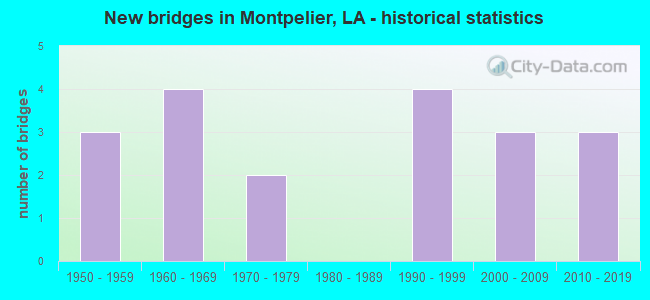
- New bridges - historical statistics
- 31950-1959
- 41960-1969
- 21970-1979
- 41990-1999
- 32000-2009
- 32010-2019


- Bridge Condition - Deck
- 7.1%Very good
- 64.3%Good
- 14.3%Satisfactory
- 7.1%Fair
- 7.1%Failed

- Bridge Condition - Superstructure
- 7.1%Very good
- 64.3%Good
- 14.3%Satisfactory
- 7.1%Fair
- 7.1%Serious

- Bridge Condition - Substructure
- 14.3%Very good
- 50.0%Good
- 21.4%Satisfactory
- 7.1%Poor
- 7.1%Imminent failure

- Bridge Condition - Channel
- 26.3%Very good
- 42.1%Good
- 21.1%Satisfactory
- 5.3%Fair
- 5.3%Poor

- Bridge Condition - Culverts
- 20.0%Very good
- 60.0%Good
- 20.0%Satisfactory
Find on map >> Show street view
Structure Number: 623202700305251, Location: 5.25 MILES NORTH OF 442 (Lat: 30.636000, Lng: -90.651900), Route carried "on" structure: State highway 441, Year Built: 2004, Status: Open, Structure Length: 1.25m (4.10ft), Average Daily Traffic: 2,300 (year 2016), Truck Traffic: 13%, Average Future Daily Traffic: 2,064 (year 2036), Design Load: HS 20, Features Intersected: CREEK
Minimum Vertical Clearance: 30+ m (98+ ft), Kilometerpoint: 8.444, Lanes on structure: 2, Owner: State Highway Agency, Approaching Roadway Width: 8.8m (28.9ft), Material/Design: Concrete, Design/Construction: Culvert, Number Of Spans In Main Unit: 5, Length of Maximum Span: 2.1m (6.9ft), Curb-To-Curb Width: 8.8m (28.9ft), Out-to-Out Width: 9.1m (29.9ft)
Condition: Channel: Satisfactory, Culverts: Good, Operating Rating: 32.4 metric tons, Method Used To Determine Operating Rating: Load and Resistance Factor Rating (LRFR) rating reported by rating factor(RF) method using HL-93 loadings, Inventory Rating: 24.9 metric tons, Method Used To Determine Inventory Rating: Load and Resistance Factor Rating (LRFR) rating reported by rating factor(RF) method using HL-93 loadings, Structural Evaluation: Equal to present minimum criteria, Deck Geometry: Meets minimum limits, Waterway Adequacy: Better than present minimum criteria, Approach Roadway Alignment: Better than present minimum criteria, Designated Inspection Frequency: Every 24 months, Inspection Date: January 2022, Deck Structure Type: Concrete Cast-file-Place
Find on map >> Show street view
Structure Number: 623202700306061, Location: 6.06 MI NORTH JCT LA 442 (Lat: 30.647831, Lng: -90.651900), Route carried "on" structure: State highway 441, Year Built: 2004, Status: Open, Structure Length: 1.25m (4.10ft), Average Daily Traffic: 2,300 (year 2016), Truck Traffic: 13%, Average Future Daily Traffic: 2,064 (year 2036), Design Load: HS 20, Features Intersected: CREEK
Minimum Vertical Clearance: 30+ m (98+ ft), Kilometerpoint: 9.756, Lanes on structure: 2, Owner: State Highway Agency, Approaching Roadway Width: 6.7m (22.0ft), Material/Design: Concrete, Design/Construction: Culvert, Number Of Spans In Main Unit: 5, Length of Maximum Span: 2.1m (6.9ft), Curb-To-Curb Width: 9.2m (30.2ft), Out-to-Out Width: 9.2m (30.2ft)
Condition: Channel: Good, Culverts: Good, Operating Rating: 42.1 metric tons, Method Used To Determine Operating Rating: Load and Resistance Factor Rating (LRFR) rating reported by rating factor(RF) method using HL-93 loadings, Inventory Rating: 32.4 metric tons, Method Used To Determine Inventory Rating: Load and Resistance Factor Rating (LRFR) rating reported by rating factor(RF) method using HL-93 loadings, Structural Evaluation: Better than present minimum criteria, Deck Geometry: Meets minimum limits, Waterway Adequacy: Better than present minimum criteria, Approach Roadway Alignment: Better than present minimum criteria, Designated Inspection Frequency: Every 24 months, Inspection Date: January 2022, Deck Structure Type: Concrete Cast-file-Place
Find on map >> Show street view
Structure Number: 624600000106035, Location: 2.1 MILES WEST LA 16 (Lat: 30.717281, Lng: -90.612581), Route carried "on" structure: County highway , Year Built: 2010, Status: Open, Structure Length: 0.85m (2.79ft), Average Daily Traffic: 350 (year 2009), Average Future Daily Traffic: 399 (year 2036), Design Load: HS 20, Features Intersected: KILLIAN BRANCH CREEK, Facility Carried by Structure: McDaniel Rd
Minimum Vertical Clearance: 30+ m (98+ ft), Kilometerpoint: 0.000, Lanes on structure: 2, Owner: County Highway Agency, Approaching Roadway Width: 5.8m (19.0ft), Material/Design: Concrete, Design/Construction: Culvert, Number Of Spans In Main Unit: 4, Length of Maximum Span: 1.8m (5.9ft), Curb-To-Curb Width: 12.8m (42.0ft), Out-to-Out Width: 13.4m (44.0ft)
Condition: Channel: Good, Culverts: Very good, Operating Rating: 42.1 metric tons, Method Used To Determine Operating Rating: Load and Resistance Factor Rating (LRFR) rating reported by rating factor(RF) method using HL-93 loadings, Inventory Rating: 32.4 metric tons, Method Used To Determine Inventory Rating: Load and Resistance Factor Rating (LRFR) rating reported by rating factor(RF) method using HL-93 loadings, Structural Evaluation: Equal to present desirable criteria, Deck Geometry: Superior to present desirable criteria, Waterway Adequacy: Better than present minimum criteria, Approach Roadway Alignment: Better than present minimum criteria, Designated Inspection Frequency: Every 24 months, Inspection Date: March 2020, Deck Structure Type: Concrete Precast Panels
Find on map >> Show street view
Structure Number: 624600000106042, Location: 3.6 MILES WEST OF LA 43 (Lat: 30.708019, Lng: -90.699311), Route carried "on" structure: County highway , Year Built: 2010, Status: Open, Structure Length: 2.44m (8.01ft), Average Daily Traffic: 50 (year 2010), Average Future Daily Traffic: 57 (year 2036), Design Load: HS 20, Features Intersected: EAST HOG BRANCH, Facility Carried by Structure: Shiloh Baptist Rd
Minimum Vertical Clearance: 30+ m (98+ ft), Kilometerpoint: 0.000, Lanes on structure: 2, Owner: County Highway Agency, Approaching Roadway Width: 6.7m (22.0ft), Material/Design: Concrete, Design/Construction: Slab, Number Of Spans In Main Unit: 4, Length of Maximum Span: 6.1m (20.0ft), Curb-To-Curb Width: 5.5m (18.0ft), Out-to-Out Width: 5.9m (19.4ft)
Condition: Deck: Good, Superstructure: Good, Substructure: Very good, Channel: Good, Operating Rating: 49.2 metric tons, Method Used To Determine Operating Rating: Load and Resistance Factor Rating (LRFR) rating reported by rating factor(RF) method using HL-93 loadings, Inventory Rating: 37.9 metric tons, Method Used To Determine Inventory Rating: Load and Resistance Factor Rating (LRFR) rating reported by rating factor(RF) method using HL-93 loadings, Structural Evaluation: Better than present minimum criteria, Deck Geometry: Meets minimum limits, Waterway Adequacy: Better than present minimum criteria, Approach Roadway Alignment: Better than present minimum criteria, Designated Inspection Frequency: Every 24 months, Inspection Date: March 2020, Deck Structure Type: Concrete Precast Panels
Find on map >> Show street view
Structure Number: 624600000106043, Location: 2.4 MILES NORTH OF LA 43 (Lat: 30.700661, Lng: -90.683981), Route carried "on" structure: County highway , Year Built: 2009, Status: Open, Structure Length: 1.28m (4.20ft), Average Daily Traffic: 75 (year 2009), Truck Traffic: 10%, Average Future Daily Traffic: 85 (year 2036), Design Load: HS 20, Features Intersected: CREEK, Facility Carried by Structure: Shiloh Baptist Rd
Minimum Vertical Clearance: 30+ m (98+ ft), Kilometerpoint: 0.000, Lanes on structure: 2, Owner: County Highway Agency, Approaching Roadway Width: 5.8m (19.0ft), Material/Design: Concrete, Design/Construction: Culvert, Number Of Spans In Main Unit: 5, Length of Maximum Span: 1.5m (4.9ft)
Condition: Channel: Very good, Culverts: Good, Operating Rating: 42.1 metric tons, Method Used To Determine Operating Rating: Load and Resistance Factor Rating (LRFR) rating reported by rating factor(RF) method using HL-93 loadings, Inventory Rating: 32.4 metric tons, Method Used To Determine Inventory Rating: Load and Resistance Factor Rating (LRFR) rating reported by rating factor(RF) method using HL-93 loadings, Structural Evaluation: Better than present minimum criteria, Waterway Adequacy: Equal to present minimum criteria, Approach Roadway Alignment: Equal to present desirable criteria, Designated Inspection Frequency: Every 24 months, Inspection Date: March 2020
Find on map >> Show street view
Structure Number: 624600000620015, Location: 0.2 Mi S of LA 16 (Lat: 30.687581, Lng: -90.699881), Route carried "on" structure: County highway , Year Built: 2019, Status: Open, Structure Length: 1.83m (6.00ft), Average Daily Traffic: 500 (year 2010), Average Future Daily Traffic: 550 (year 2030), Design Load: Greater than HL93, Features Intersected: Coffman Creek, Facility Carried by Structure: Williams Rd
Minimum Vertical Clearance: 30+ m (98+ ft), Kilometerpoint: 1.407, Lanes on structure: 2, Owner: County Highway Agency, Approaching Roadway Width: 7.6m (24.9ft), Skew: 7 degrees, Material/Design: Concrete, Design/Construction: Slab, Number Of Spans In Main Unit: 3, Length of Maximum Span: 6.1m (20.0ft), Curb-To-Curb Width: 7.6m (24.9ft), Out-to-Out Width: 8.3m (27.2ft)
Condition: Deck: Very good, Superstructure: Very good, Substructure: Very good, Channel: Very good, Operating Rating: 59.9 metric tons, Method Used To Determine Operating Rating: Load and Resistance Factor Rating (LRFR) rating reported by rating factor(RF) method using HL-93 loadings, Inventory Rating: 46.0 metric tons, Method Used To Determine Inventory Rating: Load and Resistance Factor Rating (LRFR) rating reported by rating factor(RF) method using HL-93 loadings, Structural Evaluation: Equal to present desirable criteria, Deck Geometry: Meets minimum limits, Waterway Adequacy: Better than present minimum criteria, Approach Roadway Alignment: Better than present minimum criteria, Designated Inspection Frequency: Every 24 months, Inspection Date: October 2021, Deck Structure Type: Concrete Cast-file-Place
Find on map >> Show street view
Structure Number: 624602600900101, Location: 0.1 M N OF LA 16 (Lat: 30.694031, Lng: -90.621700), Route carried "on" structure: State highway 441, Year Built: 1957, Status: Open, Structure Length: 2.44m (8.01ft), Average Daily Traffic: 670 (year 2016), Truck Traffic: 13%, Average Future Daily Traffic: 763 (year 2036), Design Load: H 15, Features Intersected: KILLIAN BRANCH
Minimum Vertical Clearance: 30+ m (98+ ft), Kilometerpoint: 0.167, Lanes on structure: 2, Owner: State Highway Agency, Approaching Roadway Width: 9.1m (29.9ft), Material/Design: Concrete, Design/Construction: Slab, Number Of Spans In Main Unit: 4, Length of Maximum Span: 6.1m (20.0ft), Curb-To-Curb Width: 7.3m (24.0ft), Out-to-Out Width: 8.8m (28.9ft)
Condition: Deck: Good, Superstructure: Good, Substructure: Good, Channel: Good, Operating Rating: 34.5 metric tons, Method Used To Determine Operating Rating: Load Factor (LF), Inventory Rating: 20.9 metric tons, Method Used To Determine Inventory Rating: Load Factor (LF), Structural Evaluation: Somewhat better than minimum adequacy, Deck Geometry: Meets minimum limits, Waterway Adequacy: Better than present minimum criteria, Approach Roadway Alignment: Equal to present desirable criteria, Designated Inspection Frequency: Every 24 months, Inspection Date: September 2020, Deck Structure Type: Concrete Cast-file-Place
Find on map >> Show street view
Structure Number: 624602620502351, Location: 4.0 M W OF LA 441 (Lat: 30.696711, Lng: -90.716800), Route carried "on" structure: State highway 16, Year Built: 1976, Status: Open, Structure Length: 1.77m (5.81ft), Average Daily Traffic: 4,000 (year 2016), Truck Traffic: 11%, Average Future Daily Traffic: 4,446 (year 2036), Design Load: HS 20, Features Intersected: COFFMAN CREEK
Minimum Vertical Clearance: 30+ m (98+ ft), Kilometerpoint: 3.759, Lanes on structure: 2, Base Highway Network: Yes (Inventory Route: 262-05-1, Subroute: 10), Owner: State Highway Agency, Approaching Roadway Width: 12.2m (40.0ft), Material/Design: Concrete, Design/Construction: Slab, Number Of Spans In Main Unit: 5, Length of Maximum Span: 5.8m (19.0ft), Curb-To-Curb Width: 12.2m (40.0ft), Out-to-Out Width: 13.1m (43.0ft)
Condition: Deck: Good, Superstructure: Good, Substructure: Satisfactory, Channel: Very good, Operating Rating: 62.6 metric tons, Method Used To Determine Operating Rating: Load Factor (LF), Inventory Rating: 37.2 metric tons, Method Used To Determine Inventory Rating: Load Factor (LF), Structural Evaluation: Equal to present minimum criteria, Deck Geometry: Equal to present minimum criteria, Waterway Adequacy: Equal to present desirable criteria, Approach Roadway Alignment: Equal to present desirable criteria, Designated Inspection Frequency: Every 24 months, Inspection Date: October 2020, Deck Structure Type: Concrete Precast Panels
Find on map >> Show street view
Structure Number: 624602620502951, Location: 3.2 M W OF LA 441 (Lat: 30.693369, Lng: -90.707500), Route carried "on" structure: State highway 16, Year Built: 1976, Status: Open, Structure Length: 1.77m (5.81ft), Average Daily Traffic: 4,000 (year 2016), Truck Traffic: 11%, Average Future Daily Traffic: 4,446 (year 2036), Design Load: HS 20, Features Intersected: DRAIN
Minimum Vertical Clearance: 30+ m (98+ ft), Kilometerpoint: 4.725, Lanes on structure: 2, Base Highway Network: Yes (Inventory Route: 262-05-1, Subroute: 10), Owner: State Highway Agency, Approaching Roadway Width: 12.2m (40.0ft), Material/Design: Concrete, Design/Construction: Slab, Number Of Spans In Main Unit: 3, Length of Maximum Span: 5.8m (19.0ft), Curb-To-Curb Width: 12.2m (40.0ft), Out-to-Out Width: 13.1m (43.0ft)
Condition: Deck: Satisfactory, Superstructure: Satisfactory, Substructure: Satisfactory, Channel: Good, Operating Rating: 62.6 metric tons, Method Used To Determine Operating Rating: Load Factor (LF), Inventory Rating: 37.2 metric tons, Method Used To Determine Inventory Rating: Load Factor (LF), Structural Evaluation: Equal to present minimum criteria, Deck Geometry: Equal to present minimum criteria, Waterway Adequacy: Equal to present desirable criteria, Approach Roadway Alignment: Equal to present desirable criteria, Designated Inspection Frequency: Every 24 months, Inspection Date: October 2020, Deck Structure Type: Concrete Precast Panels, Wearing Surface/Protective System: Wearing Surface: Bituminous
Find on map >> Show street view
Structure Number: 624602620503711, Location: 3.7M EAST OF LA 449 (Lat: 30.689219, Lng: -90.696000), Route carried "on" structure: State highway 16, Year Built: 1991, Status: Open, Structure Length: 4.88m (16.01ft), Average Daily Traffic: 4,000 (year 2016), Truck Traffic: 11%, Average Future Daily Traffic: 4,446 (year 2036), Design Load: HS 20, Features Intersected: EAST HOG BRANCH
Minimum Vertical Clearance: 30+ m (98+ ft), Kilometerpoint: 5.922, Lanes on structure: 2, Base Highway Network: Yes (Inventory Route: 262-05-1, Subroute: 10), Owner: State Highway Agency, Approaching Roadway Width: 15.2m (49.9ft), Material/Design: Concrete, Design/Construction: Slab, Number Of Spans In Main Unit: 8, Length of Maximum Span: 6.1m (20.0ft), Curb-To-Curb Width: 12.2m (40.0ft), Out-to-Out Width: 13.0m (42.7ft)
Condition: Deck: Good, Superstructure: Good, Substructure: Good, Channel: Good, Operating Rating: 72.6 metric tons, Method Used To Determine Operating Rating: Load Factor (LF), Inventory Rating: 43.5 metric tons, Method Used To Determine Inventory Rating: Load Factor (LF), Structural Evaluation: Better than present minimum criteria, Deck Geometry: Equal to present minimum criteria, Waterway Adequacy: Equal to present desirable criteria, Approach Roadway Alignment: Equal to present desirable criteria, Designated Inspection Frequency: Every 24 months, Inspection Date: November 2020, Deck Structure Type: Concrete Cast-file-Place
Find on map >> Show street view
Structure Number: 624602620505611, Location: 5.6M EAST OF LA 449 (Lat: 30.682561, Lng: -90.665100), Route carried "on" structure: State highway 16, Year Built: 1991, Status: Open, Structure Length: 1.16m (3.81ft), Average Daily Traffic: 4,000 (year 2016), Truck Traffic: 11%, Average Future Daily Traffic: 4,446 (year 2036), Design Load: HS 20, Features Intersected: BEAR CREEK
Minimum Vertical Clearance: 30+ m (98+ ft), Kilometerpoint: 8.980, Lanes on structure: 2, Base Highway Network: Yes (Inventory Route: 262-05-1, Subroute: 10), Owner: State Highway Agency, Approaching Roadway Width: 12.2m (40.0ft), Material/Design: Steel, Design/Construction: Culvert, Number Of Spans In Main Unit: 4, Length of Maximum Span: 2.4m (7.9ft)
Condition: Channel: Good, Culverts: Satisfactory, Operating Rating: 97.2 metric tons, Method Used To Determine Operating Rating: Load and Resistance Factor Rating (LRFR) rating reported by rating factor(RF) method using HL-93 loadings, Inventory Rating: 74.5 metric tons, Method Used To Determine Inventory Rating: Load and Resistance Factor Rating (LRFR) rating reported by rating factor(RF) method using HL-93 loadings, Structural Evaluation: Equal to present minimum criteria, Waterway Adequacy: Equal to present desirable criteria, Approach Roadway Alignment: Equal to present desirable criteria, Designated Inspection Frequency: Every 24 months, Inspection Date: November 2020
Find on map >> Show street view
Structure Number: 624602620600301, Location: 0.30M E JCT LA441 & LA16 (Lat: 30.684661, Lng: -90.644800), Route carried "on" structure: State highway 16, Year Built: 1992, Status: Open, Structure Length: 25.97m (85.20ft), Average Daily Traffic: 4,600 (year 2016), Truck Traffic: 11%, Average Future Daily Traffic: 5,244 (year 2036), Design Load: HS 20, Features Intersected: TICKFAW RIVER
Minimum Vertical Clearance: 30+ m (98+ ft), Kilometerpoint: 0.781, Lanes on structure: 2, Base Highway Network: Yes (Inventory Route: 262-06-1, Subroute: 10), Owner: County Highway Agency, Approaching Roadway Width: 12.2m (40.0ft), Material/Design: Prestressed concrete continuous, Design/Construction: Stringer/Multi-beam, Number Of Spans In Main Unit: 17, Length of Maximum Span: 15.2m (49.9ft), Curb-To-Curb Width: 12.2m (40.0ft), Out-to-Out Width: 13.0m (42.7ft)
Condition: Deck: Good, Superstructure: Good, Substructure: Good, Channel: Very good, Operating Rating: 59.0 metric tons, Method Used To Determine Operating Rating: Load Factor (LF), Inventory Rating: 35.4 metric tons, Method Used To Determine Inventory Rating: Load Factor (LF), Structural Evaluation: Better than present minimum criteria, Deck Geometry: Equal to present minimum criteria, Waterway Adequacy: Equal to present desirable criteria, Approach Roadway Alignment: Equal to present desirable criteria, Designated Inspection Frequency: Every 24 months, Inspection Date: November 2020, Deck Structure Type: Concrete Cast-file-Place
Find on map >> Show street view
Structure Number: 624602620601751, Location: 1.75M E JCT LA441 & LA16 (Lat: 30.692231, Lng: -90.624000), Route carried "on" structure: State highway 16, Year Built: 1992, Status: Open, Structure Length: 3.66m (12.01ft), Average Daily Traffic: 4,600 (year 2016), Truck Traffic: 11%, Average Future Daily Traffic: 5,244 (year 2036), Design Load: HS 20, Features Intersected: KILLIAN'S BRANCH
Minimum Vertical Clearance: 30+ m (98+ ft), Kilometerpoint: 3.034, Lanes on structure: 2, Base Highway Network: Yes (Inventory Route: 262-06-1, Subroute: 10), Owner: State Highway Agency, Approaching Roadway Width: 12.2m (40.0ft), Material/Design: Concrete, Design/Construction: Slab, Number Of Spans In Main Unit: 6, Length of Maximum Span: 6.1m (20.0ft), Curb-To-Curb Width: 12.2m (40.0ft), Out-to-Out Width: 13.0m (42.7ft)
Condition: Deck: Good, Superstructure: Good, Substructure: Good, Channel: Good, Operating Rating: 65.3 metric tons, Method Used To Determine Operating Rating: Load Factor (LF), Inventory Rating: 39.0 metric tons, Method Used To Determine Inventory Rating: Load Factor (LF), Structural Evaluation: Better than present minimum criteria, Deck Geometry: Equal to present minimum criteria, Waterway Adequacy: Equal to present desirable criteria, Approach Roadway Alignment: Equal to present desirable criteria, Designated Inspection Frequency: Every 24 months, Inspection Date: November 2020, Deck Structure Type: Concrete Cast-file-Place
Find on map >> Show street view
Structure Number: 624602700501191, Location: LA0043 (Lat: 30.696661, Lng: -90.648600), Route carried "on" structure: State highway 43, Year Built: 1957, Status: Open, Structure Length: 6.71m (22.01ft), Average Daily Traffic: 840 (year 2016), Truck Traffic: 12%, Average Future Daily Traffic: 934 (year 2036), Design Load: H 15, Features Intersected: TWELVE MILE CREEK
Minimum Vertical Clearance: 30+ m (98+ ft), Kilometerpoint: 1.915, Lanes on structure: 2, Owner: State Highway Agency, Approaching Roadway Width: 9.1m (29.9ft), Material/Design: Concrete, Design/Construction: Slab, Number Of Spans In Main Unit: 11, Length of Maximum Span: 6.1m (20.0ft), Curb-To-Curb Width: 7.3m (24.0ft), Out-to-Out Width: 9.0m (29.5ft)
Condition: Deck: Satisfactory, Superstructure: Satisfactory, Substructure: Satisfactory, Channel: Very good, Operating Rating: 32.7 metric tons, Method Used To Determine Operating Rating: Load Factor (LF), Inventory Rating: 19.0 metric tons, Method Used To Determine Inventory Rating: Load Factor (LF), Structural Evaluation: Somewhat better than minimum adequacy, Deck Geometry: Meets minimum limits, Waterway Adequacy: Equal to present desirable criteria, Approach Roadway Alignment: Equal to present desirable criteria, Designated Inspection Frequency: Every 24 months, Underwater Inspection Frequency: Every 60 months, Inspection Date: September 2020, Underwater Inspection Date: September 2020, Deck Structure Type: Concrete Cast-file-Place
Find on map >> Show street view
Structure Number: 624608460101851, Location: LA1036 (Lat: 30.671639, Lng: -90.690300), Route carried "on" structure: State highway 1036, Year Built: 1962, Status: Open, Structure Length: 6.10m (20.01ft), Average Daily Traffic: 540 (year 2016), Truck Traffic: 13%, Average Future Daily Traffic: 615 (year 2036), Design Load: HS 20, Features Intersected: EAST HOG BRANCH
Minimum Vertical Clearance: 30+ m (98+ ft), Kilometerpoint: 2.908, Lanes on structure: 2, Owner: State Highway Agency, Approaching Roadway Width: 8.5m (27.9ft), Material/Design: Concrete, Design/Construction: Slab, Number Of Spans In Main Unit: 10, Length of Maximum Span: 6.1m (20.0ft), Curb-To-Curb Width: 7.3m (24.0ft), Out-to-Out Width: 8.9m (29.2ft)
Condition: Deck: Good, Superstructure: Good, Substructure: Good, Channel: Satisfactory, Operating Rating: 43.5 metric tons, Method Used To Determine Operating Rating: Load Factor (LF), Inventory Rating: 26.3 metric tons, Method Used To Determine Inventory Rating: Load Factor (LF), Structural Evaluation: Equal to present minimum criteria, Deck Geometry: Meets minimum limits, Waterway Adequacy: Equal to present desirable criteria, Approach Roadway Alignment: Equal to present desirable criteria, Designated Inspection Frequency: Every 24 months, Inspection Date: November 2020, Deck Structure Type: Concrete Cast-file-Place, Wearing Surface/Protective System: Wearing Surface: Bituminous
Find on map >> Show street view
Structure Number: 624608460101911, Location: LA1036 (Lat: 30.671639, Lng: -90.689300), Route carried "on" structure: State highway 1036, Year Built: 1962, Status: Open, Structure Length: 3.05m (10.01ft), Average Daily Traffic: 540 (year 2016), Truck Traffic: 13%, Average Future Daily Traffic: 615 (year 2036), Design Load: HS 20, Features Intersected: EAST SPRING BRANCH
Minimum Vertical Clearance: 30+ m (98+ ft), Kilometerpoint: 3.011, Lanes on structure: 2, Owner: State Highway Agency, Approaching Roadway Width: 8.5m (27.9ft), Material/Design: Concrete, Design/Construction: Slab, Number Of Spans In Main Unit: 5, Length of Maximum Span: 6.1m (20.0ft), Curb-To-Curb Width: 7.3m (24.0ft), Out-to-Out Width: 8.9m (29.2ft)
Condition: Deck: Good, Superstructure: Good, Substructure: Good, Channel: Satisfactory, Operating Rating: 36.3 metric tons, Method Used To Determine Operating Rating: Load Factor (LF), Inventory Rating: 21.8 metric tons, Method Used To Determine Inventory Rating: Load Factor (LF), Structural Evaluation: Somewhat better than minimum adequacy, Deck Geometry: Meets minimum limits, Waterway Adequacy: Equal to present desirable criteria, Approach Roadway Alignment: Equal to present desirable criteria, Designated Inspection Frequency: Every 24 months, Inspection Date: November 2020, Deck Structure Type: Concrete Cast-file-Place, Wearing Surface/Protective System: Wearing Surface: Bituminous
Find on map >> Show street view
Structure Number: 624608460103401, Location: LA1036 (Lat: 30.674211, Lng: -90.664600), Route carried "on" structure: State highway 1036, Year Built: 1962, Status: Open, Structure Length: 3.66m (12.01ft), Average Daily Traffic: 540 (year 2016), Truck Traffic: 13%, Average Future Daily Traffic: 615 (year 2036), Design Load: HS 20, Features Intersected: BEAR CREEK
Minimum Vertical Clearance: 30+ m (98+ ft), Kilometerpoint: 5.391, Lanes on structure: 2, Owner: State Highway Agency, Approaching Roadway Width: 8.5m (27.9ft), Material/Design: Concrete, Design/Construction: Slab, Number Of Spans In Main Unit: 6, Length of Maximum Span: 6.1m (20.0ft), Curb-To-Curb Width: 7.3m (24.0ft), Out-to-Out Width: 8.9m (29.2ft)
Condition: Deck: Good, Superstructure: Good, Substructure: Good, Channel: Satisfactory, Operating Rating: 36.3 metric tons, Method Used To Determine Operating Rating: Load Factor (LF), Inventory Rating: 21.8 metric tons, Method Used To Determine Inventory Rating: Load Factor (LF), Structural Evaluation: Somewhat better than minimum adequacy, Deck Geometry: Meets minimum limits, Waterway Adequacy: Equal to present desirable criteria, Approach Roadway Alignment: Equal to present desirable criteria, Designated Inspection Frequency: Every 24 months, Inspection Date: November 2020, Deck Structure Type: Concrete Cast-file-Place, Wearing Surface/Protective System: Wearing Surface: Bituminous
Find on map >> Show street view
Structure Number: 624630421903551, Location: 0.4MI.S.OF LA.16 (Lat: 30.699119, Lng: -90.591511), Route carried "on" structure: County highway , Year Built: 1964, Status: Posted for load, Structure Length: 1.22m (4.00ft), Average Daily Traffic: 700 (year 1974), Average Future Daily Traffic: 798 (year 2036), Design Load: H 15, Features Intersected: CREEK, Facility Carried by Structure: Sawmill Rd
Minimum Vertical Clearance: 30+ m (98+ ft), Kilometerpoint: 0.000, Lanes on structure: 2, Owner: County Highway Agency, Approaching Roadway Width: 6.7m (22.0ft), Material/Design: Wood or Timber, Design/Construction: Stringer/Multi-beam, Number Of Spans In Main Unit: 2, Length of Maximum Span: 6.1m (20.0ft), Curb-To-Curb Width: 7.3m (24.0ft), Out-to-Out Width: 8.1m (26.6ft)
Condition: Deck: Fair, Superstructure: Fair, Substructure: Poor, Channel: Fair, Operating Rating: 24.5 metric tons, Method Used To Determine Operating Rating: Allowable Stress (AS), Inventory Rating: 18.1 metric tons, Method Used To Determine Inventory Rating: Allowable Stress (AS), Structural Evaluation: Meets minimum limits, Deck Geometry: Meets minimum limits, Waterway Adequacy: Better than present minimum criteria, Approach Roadway Alignment: Better than present minimum criteria, Bridge Posting: Required (Relationship of Operating Rating to Maximum Legal Load: 0.1 - 9.9% below), Designated Inspection Frequency: Every 24 months, Other Special Inspection Frequency: Every 12 months, Inspection Date: May 2020, Other Special Inspection Date: May 2021, Deck Structure Type: Wood or Timber, Wearing Surface/Protective System: Wearing Surface: Bituminous
Find on map >> Show street view
Structure Number: 624630431903931, Location: 1.3 MI.W.OF D.E. (Lat: 30.720150, Lng: -90.655769), Route carried "on" structure: County highway , Year Built: 1958, Year Reconstructed: 1999, Status: Closed, Structure Length: 2.59m (8.50ft), Average Daily Traffic: 60 (year 1974), Average Future Daily Traffic: 68 (year 2036), Design Load: H 10, Features Intersected: TWELVE MILE CREEK, Facility Carried by Structure: Bobby Morgan Rd
Minimum Vertical Clearance: 30+ m (98+ ft), Kilometerpoint: 0.000, Lanes on structure: 2, Owner: County Highway Agency, Approaching Roadway Width: 4.9m (16.1ft), Material/Design: Wood or Timber, Design/Construction: Stringer/Multi-beam, Number Of Spans In Main Unit: 5, Length of Maximum Span: 5.5m (18.0ft), Curb-To-Curb Width: 5.6m (18.4ft), Out-to-Out Width: 6.2m (20.3ft)
Condition: Deck: Failed, Superstructure: Serious, Substructure: Imminent failure, Channel: Poor, Operating Rating: 11.8 metric tons, Method Used To Determine Operating Rating: Allowable Stress (AS), Inventory Rating: 7.3 metric tons, Method Used To Determine Inventory Rating: Allowable Stress (AS), Deck Geometry: Meets minimum limits, Waterway Adequacy: Meets minimum limits, Approach Roadway Alignment: Meets minimum limits, Bridge Posting: Required (Relationship of Operating Rating to Maximum Legal Load: > 39.9% below), Length Of Structure Improvement: 3.38m (11.09ft), Designated Inspection Frequency: Every 24 months, Other Special Inspection Frequency: Every 6 months, Inspection Date: June 2020, Other Special Inspection Date: December 2021, Bridge Improvement Cost: $202,000, Total Project Cost: $303,000 ( Estimate for 2016), Deck Structure Type: Wood or Timber, Wearing Surface/Protective System: Wearing Surface: Other