Bridge Statistics for Montrose, West Virginia (WV)
Condition, Traffic, Stress, Structural Evaluation, Project Costs
- National Bridge Inventory (NBI) Statistics
- 19Number of bridges
- 157ft / 48.3mTotal length
- $1,925,000Total costs
- 13,910Total average daily traffic
- 1,430Total average daily truck traffic
- National Bridge Inventory (NBI) Registered Bridges for Montrose
- No street view available for this location
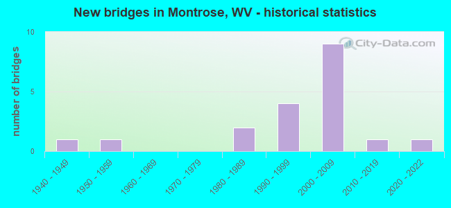
- New bridges - historical statistics
- 11940-1949
- 11950-1959
- 21980-1989
- 41990-1999
- 92000-2009
- 12010-2019
- 12020-2022


- Bridge Condition - Deck
- 33.3%Good
- 50.0%Satisfactory
- 8.3%Fair
- 8.3%Poor

- Bridge Condition - Superstructure
- 7.7%Very good
- 38.5%Good
- 46.2%Satisfactory
- 7.7%Fair

- Bridge Condition - Substructure
- 61.5%Good
- 30.8%Satisfactory
- 7.7%Poor

- Bridge Condition - Channel
- 17.6%Very good
- 58.8%Good
- 17.6%Satisfactory
- 5.9%Fair

- Bridge Condition - Culverts
- 50.0%Good
- 25.0%Satisfactory
- 25.0%Poor
Find on map >> Show street view
Structure Number: 42A004, Location: 0.48 MI S JCT CR 1/6 (Lat: 39.053031, Lng: -79.825900), Route carried "on" structure: County highway 102, Year Built: 1958, Status: Open, Structure Length: 0.80m (2.62ft), Average Daily Traffic: 50 (year 2019), Average Future Daily Traffic: 64 (year 2039), Features Intersected: CAMPFIELD RUN, Facility Carried by Structure: C R 1/2
Minimum Vertical Clearance: 30+ m (98+ ft), Kilometerpoint: 1.561, Lanes on structure: 1, Owner: State Highway Agency, Approaching Roadway Width: 4.9m (16.1ft), Skew: 2 degrees, Material/Design: Steel, Design/Construction: Girder and Floorbeam System, Number Of Spans In Main Unit: 1, Length of Maximum Span: 6.8m (22.3ft), Curb-To-Curb Width: 4.0m (13.1ft), Out-to-Out Width: 4.1m (13.5ft)
Condition: Deck: Poor, Superstructure: Satisfactory, Substructure: Poor, Channel: Fair, Operating Rating: 43.5 metric tons, Method Used To Determine Operating Rating: Load Factor (LF), Inventory Rating: 26.3 metric tons, Method Used To Determine Inventory Rating: Load Factor (LF), Structural Evaluation: Meets minimum limits, Deck Geometry: Somewhat better than minimum adequacy, Waterway Adequacy: Equal to present minimum criteria, Approach Roadway Alignment: Better than present minimum criteria, Length Of Structure Improvement: 1.22m (4.00ft), Designated Inspection Frequency: Every 24 months, Critical Feature Inspection Frequency: Every 24 months, Inspection Date: Febuary 2021, Critical Feature Inspection Date: Febuary 2021, Bridge Improvement Cost: $800,000, Roadway Improvement Cost: $250,000, Total Project Cost: $1,200,000 ( Estimate for 2021), Deck Structure Type: Wood or Timber, Wearing Surface/Protective System: Wearing Surface: Bituminous
Find on map >> Show street view
Structure Number: 42A02, Location: 0.24 MI. W.OF CR.219/86 (Lat: 39.011150, Lng: -79.817331), Route carried "on" structure: County highway 700, Year Built: 1984, Status: Open, Structure Length: 1.85m (6.07ft), Average Daily Traffic: 150 (year 2018), Truck Traffic: 5%, Average Future Daily Traffic: 192 (year 2038), Design Load: HS 20, Features Intersected: LEADING CREEK, Facility Carried by Structure: COUNTY ROUTE 7
Minimum Vertical Clearance: 30+ m (98+ ft), Kilometerpoint: 2.140, Lanes on structure: 2, Owner: State Highway Agency, Approaching Roadway Width: 4.6m (15.1ft), Material/Design: Steel, Design/Construction: Stringer/Multi-beam, Number Of Spans In Main Unit: 1, Length of Maximum Span: 17.3m (56.8ft), Curb or Sidewalk Widths: Left: 0.2m (0.7ft), Right: 0.2m (0.7ft), Curb-To-Curb Width: 6.7m (22.0ft), Out-to-Out Width: 7.8m (25.6ft)
Condition: Deck: Good, Superstructure: Good, Substructure: Satisfactory, Channel: Satisfactory, Operating Rating: 88.9 metric tons, Method Used To Determine Operating Rating: Load Factor (LF), Inventory Rating: 57.1 metric tons, Method Used To Determine Inventory Rating: Load Factor (LF), Structural Evaluation: Equal to present minimum criteria, Deck Geometry: Meets minimum limits, Waterway Adequacy: Equal to present minimum criteria, Approach Roadway Alignment: Equal to present desirable criteria, Designated Inspection Frequency: Every 48 months, Inspection Date: September 2020, Deck Structure Type: Concrete Cast-file-Place, Wearing Surface/Protective System: Wearing Surface: Monolithic Concrete, Deck Protection: Epoxy Coated Reinforcing
Find on map >> Show street view
Structure Number: 42A178, Location: 0.25 MI. N. JCT. US 219 (Lat: 39.055119, Lng: -79.818481), Route carried "on" structure: County highway 106, Year Built: 1997, Status: Open, Structure Length: 1.54m (5.05ft), Average Daily Traffic: 60 (year 2018), Average Future Daily Traffic: 77 (year 2038), Design Load: HS 25 or greater, Features Intersected: LEADING CREEK, Facility Carried by Structure: C.R. 1/6
Minimum Vertical Clearance: 30+ m (98+ ft), Kilometerpoint: 0.402, Lanes on structure: 1, Owner: State Highway Agency, Approaching Roadway Width: 5.2m (17.1ft), Material/Design: Steel, Design/Construction: Stringer/Multi-beam, Number Of Spans In Main Unit: 1, Length of Maximum Span: 14.3m (46.9ft), Curb-To-Curb Width: 4.5m (14.8ft), Out-to-Out Width: 4.9m (16.1ft)
Condition: Deck: Satisfactory, Superstructure: Good, Substructure: Satisfactory, Channel: Good, Operating Rating: 88.9 metric tons, Method Used To Determine Operating Rating: Load Factor (LF), Inventory Rating: 58.0 metric tons, Method Used To Determine Inventory Rating: Load Factor (LF), Structural Evaluation: Equal to present minimum criteria, Deck Geometry: Equal to present minimum criteria, Waterway Adequacy: Equal to present minimum criteria, Approach Roadway Alignment: Equal to present minimum criteria, Designated Inspection Frequency: Every 24 months, Inspection Date: June 2020, Deck Structure Type: Wood or Timber, Wearing Surface/Protective System: Wearing Surface: Bituminous
Find on map >> Show street view
Structure Number: 42A192, Location: 0.05 MI. W. JCT US 219 (Lat: 39.081711, Lng: -79.810689), Route carried "on" structure: County highway 200, Year Built: 2000, Status: Open, Structure Length: 1.57m (5.15ft), Average Daily Traffic: 50 (year 2018), Average Future Daily Traffic: 64 (year 2038), Design Load: HS 25 or greater, Features Intersected: LEADING CREEK, Facility Carried by Structure: CR 2
Minimum Vertical Clearance: 30+ m (98+ ft), Kilometerpoint: 0.080, Lanes on structure: 2, Owner: State Highway Agency, Approaching Roadway Width: 5.2m (17.1ft), Skew: 1 degrees, Material/Design: Prestressed concrete, Design/Construction: Box Beam or Girders - Multiple, Number Of Spans In Main Unit: 1, Length of Maximum Span: 14.6m (47.9ft), Curb-To-Curb Width: 6.2m (20.3ft), Out-to-Out Width: 6.5m (21.3ft)
Condition: Deck: Satisfactory, Superstructure: Satisfactory, Substructure: Good, Channel: Good, Operating Rating: 71.7 metric tons, Method Used To Determine Operating Rating: Load Factor (LF), Inventory Rating: 42.6 metric tons, Method Used To Determine Inventory Rating: Load Factor (LF), Structural Evaluation: Equal to present minimum criteria, Deck Geometry: Somewhat better than minimum adequacy, Waterway Adequacy: Equal to present minimum criteria, Approach Roadway Alignment: Better than present minimum criteria, Designated Inspection Frequency: Every 48 months, Inspection Date: November 2020, Deck Structure Type: Other, Wearing Surface/Protective System: Wearing Surface: Bituminous, Deck Protection: Epoxy Coated Reinforcing
Find on map >> Show street view
Structure Number: 42A198, Location: 0.14 MI. W. JCT. CR 7 (Lat: 39.013589, Lng: -79.811561), Route carried "on" structure: US 21900, Year Built: 2001, Status: Open, Structure Length: 1.58m (5.18ft), Average Daily Traffic: 2,900 (year 2019), Truck Traffic: 11%, Average Future Daily Traffic: 3,045 (year 2039), Design Load: HS 25 or greater, Features Intersected: LAZY RUN, Facility Carried by Structure: U.S.219
Minimum Vertical Clearance: 12.09m (39.67ft), Kilometerpoint: 77.297, Lanes on structure: 2, Base Highway Network: Yes, Owner: State Highway Agency, Approaching Roadway Width: 14.6m (47.9ft), Skew: 5 degrees, Material/Design: Concrete continuous, Design/Construction: Culvert, Number Of Spans In Main Unit: 4, Length of Maximum Span: 3.4m (11.2ft)
Condition: Channel: Good, Culverts: Satisfactory, Operating Rating: 61.7 metric tons, Method Used To Determine Operating Rating: Load Factor (LF), Inventory Rating: 37.2 metric tons, Method Used To Determine Inventory Rating: Load Factor (LF), Structural Evaluation: Equal to present minimum criteria, Waterway Adequacy: Equal to present minimum criteria, Approach Roadway Alignment: Better than present minimum criteria, Designated Inspection Frequency: Every 48 months, Inspection Date: September 2021
Find on map >> Show street view
Structure Number: 42A199, Location: 0.06 MI. W. JCT US 219 (Lat: 39.067989, Lng: -79.811139), Route carried "on" structure: County highway 402, Year Built: 2001, Status: Open, Structure Length: 1.24m (4.07ft), Average Daily Traffic: 600 (year 2019), Truck Traffic: 5%, Average Future Daily Traffic: 767 (year 2039), Design Load: HS 25 or greater, Features Intersected: LEADING CREEK, Facility Carried by Structure: C.R. 4/2
Minimum Vertical Clearance: 30+ m (98+ ft), Kilometerpoint: 0.097, Lanes on structure: 2, Owner: State Highway Agency, Approaching Roadway Width: 6.1m (20.0ft), Material/Design: Steel, Design/Construction: Stringer/Multi-beam, Number Of Spans In Main Unit: 1, Length of Maximum Span: 11.3m (37.1ft), Curb or Sidewalk Widths: Left: 0.0m, Right: 1.3m (4.3ft), Curb-To-Curb Width: 8.0m (26.2ft), Out-to-Out Width: 8.4m (27.6ft)
Condition: Deck: Satisfactory, Superstructure: Satisfactory, Substructure: Good, Channel: Good, Operating Rating: 79.8 metric tons, Method Used To Determine Operating Rating: Load Factor (LF), Inventory Rating: 48.1 metric tons, Method Used To Determine Inventory Rating: Load Factor (LF), Structural Evaluation: Equal to present minimum criteria, Deck Geometry: Somewhat better than minimum adequacy, Waterway Adequacy: Better than present minimum criteria, Approach Roadway Alignment: Better than present minimum criteria, Designated Inspection Frequency: Every 24 months, Inspection Date: October 2021, Deck Structure Type: Other, Wearing Surface/Protective System: Wearing Surface: Monolithic Concrete
Find on map >> Show street view
Structure Number: 42A211, Location: 0.20 MI. N. JCT US 219 (Lat: 39.013661, Lng: -79.811161), Route carried "on" structure: County highway 4800, Year Built: 2001, Status: Not yet open, Structure Length: 14.31m (46.95ft), Design Load: HS 25 or greater, Features Intersected: U.S.219, Facility Carried by Structure: CR 48
Minimum Vertical Clearance: 30+ m (98+ ft), Kilometerpoint: 65.983, Lanes on structure: 2, Lanes under structure: 2, Owner: State Highway Agency, Approaching Roadway Width: 10.4m (34.1ft), Material/Design: Prestressed concrete continuous, Design/Construction: Stringer/Multi-beam, Number Of Spans In Main Unit: 4, Length of Maximum Span: 38.0m (124.7ft), Curb-To-Curb Width: 10.2m (33.5ft), Out-to-Out Width: 11.0m (36.1ft)
Condition: Deck: Satisfactory, Superstructure: Satisfactory, Substructure: Good, Channel: Very good, Operating Rating: 53.5 metric tons, Method Used To Determine Operating Rating: Load Factor (LF), Inventory Rating: 32.7 metric tons, Method Used To Determine Inventory Rating: Load Factor (LF), Structural Evaluation: Equal to present minimum criteria, Deck Geometry: Somewhat better than minimum adequacy, Underclear: Equal to present minimum criteria, Waterway Adequacy: Superior to present desirable criteria, Approach Roadway Alignment: Equal to present desirable criteria, Designated Inspection Frequency: Every 24 months, Inspection Date: June 2021, Deck Structure Type: Concrete Cast-file-Place, Wearing Surface/Protective System: Wearing Surface: Latex Concrete, Deck Protection: Epoxy Coated Reinforcing
Find on map >> Show street view
Structure Number: 42A212, Location: 0.20 MI. N. JCT. US 219 (Lat: 39.013850, Lng: -79.811439), Route carried "on" structure: County highway 4800, Year Built: 2001, Status: Not yet open, Structure Length: 14.32m (46.98ft), Design Load: HS 25 or greater, Features Intersected: US 219, Facility Carried by Structure: US 48
Minimum Vertical Clearance: 30+ m (98+ ft), Kilometerpoint: 65.983, Lanes on structure: 2, Lanes under structure: 2, Owner: State Highway Agency, Approaching Roadway Width: 12.2m (40.0ft), Material/Design: Prestressed concrete continuous, Design/Construction: Stringer/Multi-beam, Number Of Spans In Main Unit: 4, Length of Maximum Span: 37.4m (122.7ft), Curb-To-Curb Width: 10.2m (33.5ft), Out-to-Out Width: 10.9m (35.8ft)
Condition: Deck: Satisfactory, Superstructure: Satisfactory, Substructure: Satisfactory, Channel: Very good, Operating Rating: 53.5 metric tons, Method Used To Determine Operating Rating: Load Factor (LF), Inventory Rating: 32.7 metric tons, Method Used To Determine Inventory Rating: Load Factor (LF), Structural Evaluation: Equal to present minimum criteria, Deck Geometry: Somewhat better than minimum adequacy, Underclear: Equal to present minimum criteria, Waterway Adequacy: Superior to present desirable criteria, Approach Roadway Alignment: Equal to present desirable criteria, Designated Inspection Frequency: Every 24 months, Inspection Date: June 2021, Deck Structure Type: Concrete Cast-file-Place, Wearing Surface/Protective System: Wearing Surface: Latex Concrete, Deck Protection: Epoxy Coated Reinforcing
Find on map >> Show street view
Structure Number: 42A224, Location: 0.01 MILES E JCT CR 3/3 (Lat: 39.026189, Lng: -79.819681), Route carried "on" structure: County highway 300, Year Built: 2008, Status: Open, Structure Length: 1.70m (5.58ft), Average Daily Traffic: 100 (year 2018), Average Future Daily Traffic: 128 (year 2038), Design Load: HL 93, Features Intersected: LEADING CREEK, Facility Carried by Structure: RANDOLPH CR 3
Minimum Vertical Clearance: 30+ m (98+ ft), Kilometerpoint: 2.607, Lanes on structure: 2, Owner: State Highway Agency, Approaching Roadway Width: 6.4m (21.0ft), Skew: 1 degrees, Material/Design: Prestressed concrete, Design/Construction: Box Beam or Girders - Multiple, Number Of Spans In Main Unit: 1, Length of Maximum Span: 15.9m (52.2ft), Curb-To-Curb Width: 6.2m (20.3ft), Out-to-Out Width: 6.6m (21.7ft)
Condition: Deck: Good, Superstructure: Good, Substructure: Good, Channel: Satisfactory, Operating Rating: 56.2 metric tons, Method Used To Determine Operating Rating: Load and Resistance Factor (LRFR), Inventory Rating: 43.5 metric tons, Method Used To Determine Inventory Rating: Load and Resistance Factor (LRFR), Structural Evaluation: Better than present minimum criteria, Deck Geometry: Somewhat better than minimum adequacy, Waterway Adequacy: Equal to present minimum criteria, Approach Roadway Alignment: Meets minimum limits, Designated Inspection Frequency: Every 48 months, Inspection Date: Febuary 2020, Deck Structure Type: Other, Wearing Surface/Protective System: Wearing Surface: Bituminous, Deck Protection: Epoxy Coated Reinforcing
Find on map >> Show street view
Structure Number: 42A239, Location: 0.12 mi West of U.S. 219 (Lat: 39.037489, Lng: -79.815400), Route carried "on" structure: County highway 21987, Year Built: 1999, Status: Open, Structure Length: 1.29m (4.23ft), Average Daily Traffic: 5 (year 2021), Average Future Daily Traffic: 6 (year 2041), Design Load: HS 20, Features Intersected: LEADING CREEK, Facility Carried by Structure: C.R. 219/87
Minimum Vertical Clearance: 30+ m (98+ ft), Kilometerpoint: 0.193, Lanes on structure: 1, Owner: State Highway Agency, Approaching Roadway Width: 4.0m (13.1ft), Material/Design: Concrete, Design/Construction: Culvert, Number Of Spans In Main Unit: 3, Length of Maximum Span: 3.7m (12.1ft), Curb-To-Curb Width: 5.1m (16.7ft), Out-to-Out Width: 5.1m (16.7ft)
Condition: Channel: Good, Culverts: Good, Operating Rating: 71.7 metric tons, Method Used To Determine Operating Rating: Field evaluation and documented engineering judgment, Inventory Rating: 32.7 metric tons, Method Used To Determine Inventory Rating: Field evaluation and documented engineering judgment, Structural Evaluation: Better than present minimum criteria, Deck Geometry: High priority of corrective action, Waterway Adequacy: Better than present minimum criteria, Approach Roadway Alignment: Better than present minimum criteria, Designated Inspection Frequency: Every 24 months, Inspection Date: Febuary 2021, Wearing Surface/Protective System: Wearing Surface: Bituminous
Find on map >> Show street view
Structure Number: 42A245, Location: 0.07 Mi South Jct CR 7 (Lat: 39.011931, Lng: -79.813081), Route carried "on" structure: County highway 21986, Year Built: 2014, Status: Open, Structure Length: 1.60m (5.25ft), Average Daily Traffic: 2,500 (year 2018), Truck Traffic: 11%, Average Future Daily Traffic: 3,196 (year 2038), Design Load: HL 93, Features Intersected: LAZY RUN, Facility Carried by Structure: CR 219/86
Minimum Vertical Clearance: 30+ m (98+ ft), Kilometerpoint: 8.336, Lanes on structure: 2, Owner: State Highway Agency, Approaching Roadway Width: 10.1m (33.1ft), Material/Design: Prestressed concrete, Design/Construction: Box Beam or Girders - Single/Spread, Number Of Spans In Main Unit: 1, Length of Maximum Span: 15.2m (49.9ft), Curb-To-Curb Width: 10.2m (33.5ft), Out-to-Out Width: 11.0m (36.1ft)
Condition: Deck: Good, Superstructure: Very good, Substructure: Good, Channel: Very good, Operating Rating: 50.8 metric tons, Method Used To Determine Operating Rating: Load and Resistance Factor (LRFR), Inventory Rating: 39.0 metric tons, Method Used To Determine Inventory Rating: Load and Resistance Factor (LRFR), Structural Evaluation: Better than present minimum criteria, Deck Geometry: Meets minimum limits, Waterway Adequacy: Equal to present desirable criteria, Approach Roadway Alignment: Equal to present desirable criteria, Designated Inspection Frequency: Every 48 months, Inspection Date: March 2020, Deck Structure Type: Concrete Cast-file-Place, Wearing Surface/Protective System: Wearing Surface: Monolithic Concrete, Membrane: Epoxy, Deck Protection: Epoxy Coated Reinforcing
Find on map >> Show street view
Structure Number: 42A246, Location: 0.15 MI E JCT CR 3/1 (Lat: 39.011189, Lng: -79.835081), Route carried "on" structure: County highway 700, Year Built: 1949, Status: Posted for load, Structure Length: 0.88m (2.89ft), Average Daily Traffic: 150 (year 2018), Truck Traffic: 5%, Average Future Daily Traffic: 192 (year 2038), Features Intersected: DAVIS LICK, Facility Carried by Structure: CR 7
Minimum Vertical Clearance: 30+ m (98+ ft), Kilometerpoint: 0.499, Lanes on structure: 2, Owner: State Highway Agency, Approaching Roadway Width: 5.8m (19.0ft), Skew: 3 degrees, Material/Design: Concrete, Design/Construction: Culvert, Number Of Spans In Main Unit: 1, Length of Maximum Span: 8.8m (28.9ft)
Condition: Channel: Satisfactory, Culverts: Poor, Operating Rating: 53.5 metric tons, Method Used To Determine Operating Rating: Field evaluation and documented engineering judgment, Inventory Rating: 24.5 metric tons, Method Used To Determine Inventory Rating: Field evaluation and documented engineering judgment, Structural Evaluation: Meets minimum limits, Waterway Adequacy: Equal to present minimum criteria, Approach Roadway Alignment: Equal to present desirable criteria, Length Of Structure Improvement: 0.88m (2.89ft), Designated Inspection Frequency: Every 24 months, Other Special Inspection Frequency: Every 12 months, Inspection Date: Febuary 2021, Other Special Inspection Date: Febuary 2021, Bridge Improvement Cost: $590,000, Roadway Improvement Cost: $40,000, Total Project Cost: $725,000 ( Estimate for 2021)
Find on map >> Show street view
Structure Number: 42A262, Location: 0.01 mile E jct CR 3/1 (Lat: 39.029800, Lng: -79.834750), Route carried "on" structure: County highway 302, Year Built: 2020, Status: Open, Structure Length: 0.71m (2.33ft), Average Daily Traffic: 100 (year 2018), Average Future Daily Traffic: 128 (year 2038), Design Load: HL 93, Features Intersected: Springstone Run, Facility Carried by Structure: C.R. 3/2
Minimum Vertical Clearance: 30+ m (98+ ft), Kilometerpoint: 0.274, Lanes on structure: 2, Owner: State Highway Agency, Approaching Roadway Width: 4.6m (15.1ft), Material/Design: Concrete, Design/Construction: Culvert, Number Of Spans In Main Unit: 1, Length of Maximum Span: 7.1m (23.3ft)
Condition: Channel: Good, Culverts: Good, Operating Rating: 50.8 metric tons, Method Used To Determine Operating Rating: Load and Resistance Factor (LRFR), Inventory Rating: 39.0 metric tons, Method Used To Determine Inventory Rating: Load and Resistance Factor (LRFR), Structural Evaluation: Better than present minimum criteria, Waterway Adequacy: Equal to present minimum criteria, Approach Roadway Alignment: Equal to present desirable criteria, Designated Inspection Frequency: Every 24 months, Inspection Date: December 2020
Find on map >> Show street view
Structure Number: 47A022, Location: 0.19 MI. W. JCT. CR.21 (Lat: 39.118731, Lng: -79.770700), Route carried "on" structure: County highway 2300, Year Built: 1989, Status: Open, Structure Length: 1.33m (4.36ft), Average Daily Traffic: 20 (year 2018), Average Future Daily Traffic: 23 (year 2038), Design Load: HS 25 or greater, Features Intersected: LEFT FORK CLOVER RUN, Facility Carried by Structure: CR. 23
Minimum Vertical Clearance: 30+ m (98+ ft), Kilometerpoint: 3.154, Lanes on structure: 2, Owner: State Highway Agency, Approaching Roadway Width: 4.9m (16.1ft), Skew: 1 degrees, Material/Design: Prestressed concrete, Design/Construction: Box Beam or Girders - Multiple, Number Of Spans In Main Unit: 1, Length of Maximum Span: 12.2m (40.0ft), Curb-To-Curb Width: 6.1m (20.0ft), Out-to-Out Width: 6.5m (21.3ft)
Condition: Deck: Good, Superstructure: Good, Substructure: Good, Channel: Good, Operating Rating: 88.9 metric tons, Method Used To Determine Operating Rating: Load Factor (LF), Inventory Rating: 60.8 metric tons, Method Used To Determine Inventory Rating: Load Factor (LF), Structural Evaluation: Better than present minimum criteria, Deck Geometry: Somewhat better than minimum adequacy, Waterway Adequacy: Equal to present minimum criteria, Approach Roadway Alignment: Equal to present minimum criteria, Designated Inspection Frequency: Every 48 months, Inspection Date: May 2020, Deck Structure Type: Other, Wearing Surface/Protective System: Wearing Surface: Bituminous, Deck Protection: Epoxy Coated Reinforcing
Find on map >> Show street view
Structure Number: 47A065, Location: 0.10 MI. N. JCT. CR 21 (Lat: 39.122211, Lng: -79.775200), Route carried "on" structure: County highway 800, Year Built: 1998, Status: Open, Structure Length: 1.59m (5.22ft), Average Daily Traffic: 10 (year 2019), Average Future Daily Traffic: 12 (year 2039), Design Load: HS 25 or greater, Features Intersected: INDIAN RUN, Facility Carried by Structure: C.R. 8
Minimum Vertical Clearance: 30+ m (98+ ft), Kilometerpoint: 0.161, Lanes on structure: 2, Owner: State Highway Agency, Approaching Roadway Width: 4.6m (15.1ft), Skew: 3 degrees, Material/Design: Prestressed concrete, Design/Construction: Box Beam or Girders - Multiple, Number Of Spans In Main Unit: 1, Length of Maximum Span: 14.6m (47.9ft), Curb-To-Curb Width: 6.2m (20.3ft), Out-to-Out Width: 6.5m (21.3ft)
Condition: Deck: Satisfactory, Superstructure: Satisfactory, Substructure: Good, Channel: Good, Operating Rating: 74.4 metric tons, Method Used To Determine Operating Rating: Load Factor (LF), Inventory Rating: 44.4 metric tons, Method Used To Determine Inventory Rating: Load Factor (LF), Structural Evaluation: Equal to present minimum criteria, Deck Geometry: Somewhat better than minimum adequacy, Waterway Adequacy: Better than present minimum criteria, Approach Roadway Alignment: Equal to present minimum criteria, Designated Inspection Frequency: Every 24 months, Inspection Date: March 2021, Deck Structure Type: Other, Wearing Surface/Protective System: Wearing Surface: Bituminous, Membrane: Preformed Fabric, Deck Protection: Epoxy Coated Reinforcing
Find on map >> Show street view
Structure Number: 47A068, Location: 0.76 MI. N JCT. CR 21 (Lat: 39.123011, Lng: -79.786211), Route carried "on" structure: County highway 800, Year Built: 1999, Status: Open, Structure Length: 1.16m (3.81ft), Average Daily Traffic: 10 (year 2019), Average Future Daily Traffic: 12 (year 2039), Design Load: HS 25 or greater, Features Intersected: LEFT FORK CLOVER RUN, Facility Carried by Structure: CR 8
Minimum Vertical Clearance: 30+ m (98+ ft), Kilometerpoint: 1.223, Lanes on structure: 2, Owner: State Highway Agency, Approaching Roadway Width: 5.2m (17.1ft), Skew: 4 degrees, Material/Design: Prestressed concrete, Design/Construction: Box Beam or Girders - Multiple, Number Of Spans In Main Unit: 1, Length of Maximum Span: 10.4m (34.1ft), Curb-To-Curb Width: 6.2m (20.3ft), Out-to-Out Width: 6.6m (21.7ft)
Condition: Deck: Fair, Superstructure: Fair, Substructure: Good, Channel: Good, Operating Rating: 82.5 metric tons, Method Used To Determine Operating Rating: Load Factor (LF), Inventory Rating: 49.0 metric tons, Method Used To Determine Inventory Rating: Load Factor (LF), Structural Evaluation: Somewhat better than minimum adequacy, Deck Geometry: Somewhat better than minimum adequacy, Waterway Adequacy: Better than present minimum criteria, Approach Roadway Alignment: Better than present minimum criteria, Designated Inspection Frequency: Every 24 months, Inspection Date: March 2021, Deck Structure Type: Other, Wearing Surface/Protective System: Wearing Surface: Bituminous, Membrane: Preformed Fabric, Deck Protection: Epoxy Coated Reinforcing
Find on map >> Show street view
Structure Number: 47A071, Location: 1.30 MI. N. JCT. C.R. 21 (Lat: 39.118750, Lng: -79.793611), Route carried "on" structure: County highway 800, Year Built: 2001, Status: Open, Structure Length: 0.78m (2.56ft), Average Daily Traffic: 5 (year 2021), Average Future Daily Traffic: 6 (year 2041), Design Load: HS 20, Features Intersected: LEFT FORK CLOVER RUN, Facility Carried by Structure: C.R. 8
Minimum Vertical Clearance: 30+ m (98+ ft), Kilometerpoint: 2.092, Lanes on structure: 2, Owner: State Highway Agency, Approaching Roadway Width: 4.9m (16.1ft), Material/Design: Concrete, Design/Construction: Arch - Deck, Number Of Spans In Main Unit: 1, Length of Maximum Span: 7.3m (24.0ft), Curb-To-Curb Width: 5.7m (18.7ft), Out-to-Out Width: 13.7m (44.9ft)
Condition: Superstructure: Good, Substructure: Satisfactory, Channel: Good, Operating Rating: 71.7 metric tons, Method Used To Determine Operating Rating: Field evaluation and documented engineering judgment, Inventory Rating: 32.7 metric tons, Method Used To Determine Inventory Rating: Field evaluation and documented engineering judgment, Structural Evaluation: Equal to present minimum criteria, Deck Geometry: Meets minimum limits, Waterway Adequacy: Better than present minimum criteria, Approach Roadway Alignment: Better than present minimum criteria, Designated Inspection Frequency: Every 48 months, Inspection Date: September 2021
Find on map >> Show street view
Structure Number: 42A211, Location: 0.20 MI. N. JCT US 219 (Lat: 39.013689, Lng: -79.811089), Route carried "under" structure: US 21900, Year Built: 2001, Structure Length: 0. m, Average Daily Traffic: 3,600 (year 0006), Truck Traffic: 11%, Features Intersected: U.S.219, Facility Carried by Structure: CR 48
Minimum Vertical Clearance: 12.09m (39.67ft), Kilometerpoint: 74.320, Lanes on structure: 2, Lanes under structure: 2, Length of Maximum Span: 38.0m (124.7ft)
Find on map >> Show street view
Structure Number: 42A212, Location: 0.20 MI. N. JCT. US 219 (Lat: 39.013689, Lng: -79.811089), Route carried "under" structure: US 21900, Year Built: 2001, Structure Length: 0. m, Average Daily Traffic: 3,600 (year 0007), Truck Traffic: 11%, Features Intersected: US 219, Facility Carried by Structure: US 48
Minimum Vertical Clearance: 12.09m (39.67ft), Kilometerpoint: 74.320, Lanes on structure: 2, Lanes under structure: 2, Length of Maximum Span: 37.4m (122.7ft)