Bridge Statistics for Moorcroft, Wyoming (WY)
Condition, Traffic, Stress, Structural Evaluation, Project Costs
- National Bridge Inventory (NBI) Statistics
- 32Number of bridges
- 305ft / 93.4mTotal length
- $115,000Total costs
- 105,435Total average daily traffic
- 33,267Total average daily truck traffic
- National Bridge Inventory (NBI) Registered Bridges for Moorcroft
- No street view available for this location
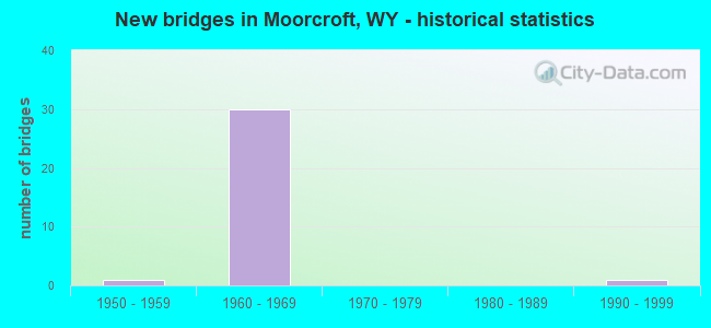
- New bridges - historical statistics
- 11950-1959
- 301960-1969
- 11990-1999
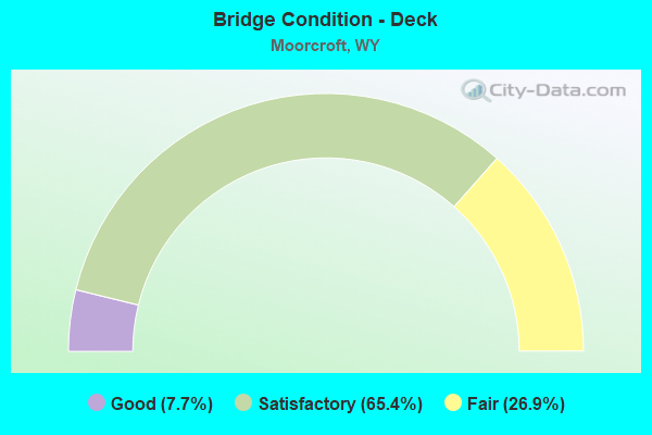
- Bridge Condition - Deck
- 7.7%Good
- 65.4%Satisfactory
- 26.9%Fair
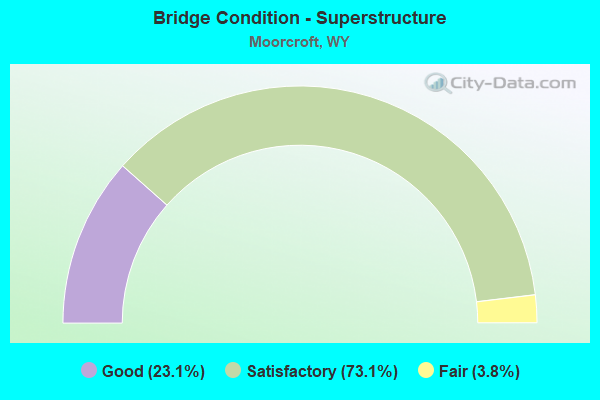
- Bridge Condition - Superstructure
- 23.1%Good
- 73.1%Satisfactory
- 3.8%Fair
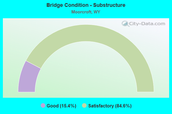
- Bridge Condition - Substructure
- 15.4%Good
- 84.6%Satisfactory
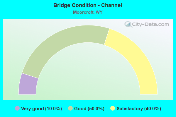
- Bridge Condition - Channel
- 10.0%Very good
- 50.0%Good
- 40.0%Satisfactory
Find on map >> Show street view
Structure Number: BGN, Location: Gillette - Moorcroft (Lat: 44.280622, Lng: -104.993769), Route carried "on" structure: Interstate 90, Year Built: 1969, Status: Open, Structure Length: 4.27m (14.01ft), Average Daily Traffic: 3,850 (year 2021), Truck Traffic: 45%, Average Future Daily Traffic: 5,390 (year 2041), Design Load: HS 20+Mod, Features Intersected: Cr CR 68 / D Road
Minimum Vertical Clearance: 30+ m (98+ ft), Kilometerpoint: 247.215, Lanes on structure: 2, Lanes under structure: 2, Base Highway Network: Yes, Owner: State Highway Agency, Approaching Roadway Width: 11.6m (38.1ft), Skew: 10 degrees, Material/Design: Concrete continuous, Design/Construction: Tee Beam, Number Of Spans In Main Unit: 3, Length of Maximum Span: 17.1m (56.1ft), Curb-To-Curb Width: 12.2m (40.0ft), Out-to-Out Width: 13.0m (42.7ft)
Condition: Deck: Satisfactory, Superstructure: Satisfactory, Substructure: Satisfactory, Operating Rating: 53.5 metric tons, Method Used To Determine Operating Rating: Load Factor (LF), Inventory Rating: 31.8 metric tons, Method Used To Determine Inventory Rating: Load Factor (LF), Structural Evaluation: Equal to present minimum criteria, Deck Geometry: Better than present minimum criteria, Underclear: Somewhat better than minimum adequacy, Approach Roadway Alignment: Equal to present desirable criteria, Designated Inspection Frequency: Every 24 months, Inspection Date: June 2021, Deck Structure Type: Concrete Cast-file-Place, Wearing Surface/Protective System: Wearing Surface: Latex Concrete
Find on map >> Show street view
Structure Number: BGO, Location: Gillette - Moorcroft (Lat: 44.280861, Lng: -104.993714), Route carried "on" structure: Interstate 90, Year Built: 1969, Status: Open, Structure Length: 4.27m (14.01ft), Average Daily Traffic: 3,720 (year 2021), Truck Traffic: 17%, Average Future Daily Traffic: 5,208 (year 2041), Design Load: HS 20+Mod, Features Intersected: Cr CR 68 / D Road
Minimum Vertical Clearance: 30+ m (98+ ft), Kilometerpoint: 247.034, Lanes on structure: 2, Lanes under structure: 2, Base Highway Network: Yes (Inventory Route: ML9, Subroute: 2), Owner: State Highway Agency, Approaching Roadway Width: 11.6m (38.1ft), Skew: 10 degrees, Material/Design: Concrete continuous, Design/Construction: Tee Beam, Number Of Spans In Main Unit: 3, Length of Maximum Span: 17.1m (56.1ft), Curb-To-Curb Width: 12.2m (40.0ft), Out-to-Out Width: 13.0m (42.7ft)
Condition: Deck: Satisfactory, Superstructure: Satisfactory, Substructure: Satisfactory, Operating Rating: 53.5 metric tons, Method Used To Determine Operating Rating: Load Factor (LF), Inventory Rating: 31.8 metric tons, Method Used To Determine Inventory Rating: Load Factor (LF), Structural Evaluation: Equal to present minimum criteria, Deck Geometry: Better than present minimum criteria, Underclear: Somewhat better than minimum adequacy, Approach Roadway Alignment: Equal to present desirable criteria, Designated Inspection Frequency: Every 24 months, Inspection Date: June 2021, Deck Structure Type: Concrete Cast-file-Place, Wearing Surface/Protective System: Wearing Surface: Latex Concrete
Find on map >> Show street view
Structure Number: BGP, Location: Gillette - Moorcroft (Lat: 44.279689, Lng: -104.989331), Route carried "on" structure: Interstate 90, Year Built: 1969, Status: Open, Structure Length: 5.43m (17.81ft), Average Daily Traffic: 3,850 (year 2021), Truck Traffic: 45%, Average Future Daily Traffic: 5,390 (year 2041), Design Load: HS 20+Mod, Features Intersected: Donkey Creek
Minimum Vertical Clearance: 30+ m (98+ ft), Kilometerpoint: 247.583, Lanes on structure: 2, Base Highway Network: Yes, Owner: State Highway Agency, Approaching Roadway Width: 11.6m (38.1ft), Skew: 14 degrees, Material/Design: Steel continuous, Design/Construction: Stringer/Multi-beam, Number Of Spans In Main Unit: 3, Length of Maximum Span: 20.7m (67.9ft), Curb-To-Curb Width: 12.2m (40.0ft), Out-to-Out Width: 13.0m (42.7ft)
Condition: Deck: Satisfactory, Superstructure: Good, Substructure: Good, Channel: Good, Operating Rating: 49.9 metric tons, Method Used To Determine Operating Rating: Load Factor (LF), Inventory Rating: 29.9 metric tons, Method Used To Determine Inventory Rating: Load Factor (LF), Structural Evaluation: Better than present minimum criteria, Deck Geometry: Better than present minimum criteria, Waterway Adequacy: Equal to present desirable criteria, Approach Roadway Alignment: Equal to present desirable criteria, Designated Inspection Frequency: Every 24 months, Inspection Date: June 2021, Deck Structure Type: Concrete Cast-file-Place, Wearing Surface/Protective System: Wearing Surface: Latex Concrete
Find on map >> Show street view
Structure Number: BGQ, Location: Gillette - Moorcroft (Lat: 44.279819, Lng: -104.988939), Route carried "on" structure: Interstate 90, Year Built: 1969, Status: Open, Structure Length: 5.43m (17.81ft), Average Daily Traffic: 3,720 (year 2021), Truck Traffic: 17%, Average Future Daily Traffic: 5,208 (year 2041), Design Load: HS 20+Mod, Features Intersected: Donkey Creek
Minimum Vertical Clearance: 30+ m (98+ ft), Kilometerpoint: 247.433, Lanes on structure: 2, Base Highway Network: Yes (Inventory Route: ML9, Subroute: 2), Owner: State Highway Agency, Approaching Roadway Width: 11.6m (38.1ft), Skew: 14 degrees, Material/Design: Steel continuous, Design/Construction: Stringer/Multi-beam, Number Of Spans In Main Unit: 3, Length of Maximum Span: 20.7m (67.9ft), Curb-To-Curb Width: 12.2m (40.0ft), Out-to-Out Width: 13.0m (42.7ft)
Condition: Deck: Fair, Superstructure: Good, Substructure: Good, Channel: Satisfactory, Operating Rating: 49.9 metric tons, Method Used To Determine Operating Rating: Load Factor (LF), Inventory Rating: 29.9 metric tons, Method Used To Determine Inventory Rating: Load Factor (LF), Structural Evaluation: Better than present minimum criteria, Deck Geometry: Better than present minimum criteria, Waterway Adequacy: Equal to present desirable criteria, Approach Roadway Alignment: Equal to present desirable criteria, Designated Inspection Frequency: Every 24 months, Inspection Date: June 2021, Deck Structure Type: Concrete Cast-file-Place
Find on map >> Show street view
Structure Number: BGR, Location: Gillette - Moorcroft (Lat: 44.279278, Lng: -104.989564), Route carried "on" structure: State highway 51, Year Built: 1956, Status: Open, Structure Length: 3.49m (11.45ft), Average Daily Traffic: 1,294 (year 2021), Truck Traffic: 13%, Average Future Daily Traffic: 1,812 (year 2041), Design Load: HS 20, Features Intersected: Donkey Creek
Minimum Vertical Clearance: 30+ m (98+ ft), Kilometerpoint: 244.080, Lanes on structure: 2, Owner: State Highway Agency, Approaching Roadway Width: 9.8m (32.2ft), Skew: 4 degrees, Material/Design: Concrete continuous, Design/Construction: Slab, Number Of Spans In Main Unit: 5, Length of Maximum Span: 7.3m (24.0ft), Curb-To-Curb Width: 9.8m (32.2ft), Out-to-Out Width: 10.7m (35.1ft)
Condition: Deck: Fair, Superstructure: Fair, Substructure: Satisfactory, Channel: Good, Operating Rating: 34.5 metric tons, Method Used To Determine Operating Rating: Load Factor (LF), Inventory Rating: 20.9 metric tons, Method Used To Determine Inventory Rating: Load Factor (LF), Structural Evaluation: Somewhat better than minimum adequacy, Deck Geometry: Somewhat better than minimum adequacy, Waterway Adequacy: Equal to present desirable criteria, Approach Roadway Alignment: Equal to present desirable criteria, Designated Inspection Frequency: Every 24 months, Inspection Date: August 2020, Deck Structure Type: Concrete Cast-file-Place, Wearing Surface/Protective System: Wearing Surface: Bituminous
Find on map >> Show street view
Structure Number: BGS, Location: Gillette - Moorcroft (Lat: 44.275489, Lng: -104.977392), Route carried "on" structure: Interstate 90, Year Built: 1966, Status: Open, Structure Length: 6.92m (22.70ft), Average Daily Traffic: 3,850 (year 2021), Truck Traffic: 45%, Average Future Daily Traffic: 5,390 (year 2041), Design Load: HS 20+Mod, Features Intersected: Belle Fourche River
Minimum Vertical Clearance: 30+ m (98+ ft), Kilometerpoint: 248.645, Lanes on structure: 2, Base Highway Network: Yes (Inventory Route: ML9, Subroute: 2), Owner: State Highway Agency, Approaching Roadway Width: 11.6m (38.1ft), Skew: 10 degrees, Material/Design: Steel continuous, Design/Construction: Stringer/Multi-beam, Number Of Spans In Main Unit: 3, Length of Maximum Span: 26.8m (87.9ft), Curb-To-Curb Width: 11.6m (38.1ft), Out-to-Out Width: 12.4m (40.7ft)
Condition: Deck: Fair, Superstructure: Satisfactory, Substructure: Satisfactory, Channel: Good, Operating Rating: 54.4 metric tons, Method Used To Determine Operating Rating: Load Factor (LF), Inventory Rating: 32.7 metric tons, Method Used To Determine Inventory Rating: Load Factor (LF), Structural Evaluation: Equal to present minimum criteria, Deck Geometry: Equal to present minimum criteria, Waterway Adequacy: Equal to present desirable criteria, Approach Roadway Alignment: Equal to present desirable criteria, Designated Inspection Frequency: Every 24 months, Inspection Date: June 2021, Deck Structure Type: Concrete Cast-file-Place, Wearing Surface/Protective System: Wearing Surface: Latex Concrete
Find on map >> Show street view
Structure Number: BGT, Location: Gillette - Moorcroft (Lat: 44.275664, Lng: -104.977286), Route carried "on" structure: Interstate 90, Year Built: 1966, Status: Open, Structure Length: 6.92m (22.70ft), Average Daily Traffic: 3,720 (year 2021), Truck Traffic: 17%, Average Future Daily Traffic: 5,208 (year 2041), Design Load: HS 20+Mod, Features Intersected: Belle Fourche River
Minimum Vertical Clearance: 30+ m (98+ ft), Kilometerpoint: 248.473, Lanes on structure: 2, Base Highway Network: Yes (Inventory Route: ML9, Subroute: 2), Owner: State Highway Agency, Approaching Roadway Width: 11.6m (38.1ft), Skew: 10 degrees, Material/Design: Steel continuous, Design/Construction: Stringer/Multi-beam, Number Of Spans In Main Unit: 3, Length of Maximum Span: 26.8m (87.9ft), Curb-To-Curb Width: 11.6m (38.1ft), Out-to-Out Width: 12.4m (40.7ft)
Condition: Deck: Fair, Superstructure: Satisfactory, Substructure: Satisfactory, Channel: Satisfactory, Operating Rating: 54.4 metric tons, Method Used To Determine Operating Rating: Load Factor (LF), Inventory Rating: 32.7 metric tons, Method Used To Determine Inventory Rating: Load Factor (LF), Structural Evaluation: Equal to present minimum criteria, Deck Geometry: Equal to present minimum criteria, Waterway Adequacy: Equal to present desirable criteria, Approach Roadway Alignment: Equal to present desirable criteria, Designated Inspection Frequency: Every 24 months, Inspection Date: June 2021, Deck Structure Type: Concrete Cast-file-Place, Wearing Surface/Protective System: Wearing Surface: Latex Concrete
Find on map >> Show street view
Structure Number: BGV, Location: Moorcroft (Lat: 44.272592, Lng: -104.968036), Route carried "on" structure: Interstate 90, Year Built: 1966, Status: Open, Structure Length: 3.54m (11.61ft), Average Daily Traffic: 3,850 (year 2021), Truck Traffic: 58%, Average Future Daily Traffic: 5,390 (year 2041), Design Load: HS 20+Mod, Features Intersected: US 14/16
Minimum Vertical Clearance: 30+ m (98+ ft), Kilometerpoint: 249.458, Lanes on structure: 2, Lanes under structure: 2, Base Highway Network: Yes (Inventory Route: ML9, Subroute: 2), Owner: State Highway Agency, Approaching Roadway Width: 11.6m (38.1ft), Skew: 10 degrees, Material/Design: Steel continuous, Design/Construction: Stringer/Multi-beam, Number Of Spans In Main Unit: 3, Length of Maximum Span: 14.9m (48.9ft), Curb-To-Curb Width: 11.6m (38.1ft), Out-to-Out Width: 12.4m (40.7ft)
Condition: Deck: Fair, Superstructure: Satisfactory, Substructure: Satisfactory, Operating Rating: 58.1 metric tons, Method Used To Determine Operating Rating: Load Factor (LF), Inventory Rating: 34.5 metric tons, Method Used To Determine Inventory Rating: Load Factor (LF), Structural Evaluation: Equal to present minimum criteria, Deck Geometry: Equal to present minimum criteria, Underclear: High priority of corrective action, Approach Roadway Alignment: Equal to present desirable criteria, Designated Inspection Frequency: Every 24 months, Inspection Date: June 2021, Deck Structure Type: Concrete Cast-file-Place, Wearing Surface/Protective System: Wearing Surface: Epoxy Overlay
Find on map >> Show street view
Structure Number: BGW, Location: Moorcroft (Lat: 44.272764, Lng: -104.967933), Route carried "on" structure: Interstate 90, Year Built: 1966, Status: Open, Structure Length: 3.54m (11.61ft), Average Daily Traffic: 3,720 (year 2021), Truck Traffic: 17%, Average Future Daily Traffic: 5,208 (year 2041), Design Load: HS 20+Mod, Features Intersected: US 14/16
Minimum Vertical Clearance: 5.36m (17.59ft), Kilometerpoint: 249.287, Lanes on structure: 2, Lanes under structure: 2, Base Highway Network: Yes (Inventory Route: ML9, Subroute: 2), Owner: State Highway Agency, Approaching Roadway Width: 11.6m (38.1ft), Skew: 10 degrees, Material/Design: Steel continuous, Design/Construction: Stringer/Multi-beam, Number Of Spans In Main Unit: 3, Length of Maximum Span: 14.9m (48.9ft), Curb-To-Curb Width: 11.6m (38.1ft), Out-to-Out Width: 12.4m (40.7ft)
Condition: Deck: Fair, Superstructure: Good, Substructure: Satisfactory, Operating Rating: 58.1 metric tons, Method Used To Determine Operating Rating: Load Factor (LF), Inventory Rating: 34.5 metric tons, Method Used To Determine Inventory Rating: Load Factor (LF), Structural Evaluation: Equal to present minimum criteria, Deck Geometry: Equal to present minimum criteria, Underclear: High priority of corrective action, Approach Roadway Alignment: Equal to present desirable criteria, Designated Inspection Frequency: Every 24 months, Inspection Date: June 2021, Deck Structure Type: Concrete Cast-file-Place, Wearing Surface/Protective System: Wearing Surface: Epoxy Overlay
Find on map >> Show street view
Structure Number: BGX, Location: Moorcroft (Lat: 44.268453, Lng: -104.950056), Route carried "on" structure: Interstate 90, Year Built: 1966, Status: Open, Structure Length: 3.99m (13.09ft), Average Daily Traffic: 3,600 (year 2021), Truck Traffic: 58%, Average Future Daily Traffic: 5,040 (year 2041), Design Load: HS 20+Mod, Features Intersected: US 14
Minimum Vertical Clearance: 30+ m (98+ ft), Kilometerpoint: 250.971, Lanes on structure: 2, Lanes under structure: 2, Base Highway Network: Yes (Inventory Route: ML9, Subroute: 2), Owner: State Highway Agency, Approaching Roadway Width: 11.9m (39.0ft), Skew: 11 degrees, Material/Design: Steel continuous, Design/Construction: Stringer/Multi-beam, Number Of Spans In Main Unit: 3, Length of Maximum Span: 16.2m (53.1ft), Curb-To-Curb Width: 11.6m (38.1ft), Out-to-Out Width: 12.4m (40.7ft)
Condition: Deck: Satisfactory, Superstructure: Satisfactory, Substructure: Good, Operating Rating: 59.9 metric tons, Method Used To Determine Operating Rating: Load Factor (LF), Inventory Rating: 35.4 metric tons, Method Used To Determine Inventory Rating: Load Factor (LF), Structural Evaluation: Equal to present minimum criteria, Deck Geometry: Equal to present minimum criteria, Underclear: Better than present minimum criteria, Approach Roadway Alignment: Equal to present desirable criteria, Length Of Structure Improvement: 3.96m (12.99ft), Designated Inspection Frequency: Every 24 months, Inspection Date: July 2021, Bridge Improvement Cost: $74,000, Roadway Improvement Cost: $37,000, Total Project Cost: $115,000 ( Estimate for 2014), Deck Structure Type: Concrete Cast-file-Place, Wearing Surface/Protective System: Wearing Surface: Latex Concrete
Find on map >> Show street view
Structure Number: BGY, Location: Moorcroft (Lat: 44.268636, Lng: -104.949942), Route carried "on" structure: Interstate 90, Year Built: 1966, Status: Open, Structure Length: 3.99m (13.09ft), Average Daily Traffic: 3,720 (year 2021), Truck Traffic: 17%, Average Future Daily Traffic: 5,208 (year 2041), Design Load: HS 20+Mod, Features Intersected: US 14
Minimum Vertical Clearance: 5.19m (17.03ft), Kilometerpoint: 250.799, Lanes on structure: 2, Lanes under structure: 2, Base Highway Network: Yes (Inventory Route: ML9, Subroute: 2), Owner: State Highway Agency, Approaching Roadway Width: 11.9m (39.0ft), Skew: 11 degrees, Material/Design: Steel continuous, Design/Construction: Stringer/Multi-beam, Number Of Spans In Main Unit: 3, Length of Maximum Span: 16.2m (53.1ft), Curb-To-Curb Width: 11.6m (38.1ft), Out-to-Out Width: 12.4m (40.7ft)
Condition: Deck: Fair, Superstructure: Satisfactory, Substructure: Satisfactory, Operating Rating: 59.9 metric tons, Method Used To Determine Operating Rating: Load Factor (LF), Inventory Rating: 35.4 metric tons, Method Used To Determine Inventory Rating: Load Factor (LF), Structural Evaluation: Equal to present minimum criteria, Deck Geometry: Equal to present minimum criteria, Underclear: Better than present minimum criteria, Approach Roadway Alignment: Equal to present desirable criteria, Designated Inspection Frequency: Every 24 months, Inspection Date: July 2021, Deck Structure Type: Concrete Cast-file-Place
Find on map >> Show street view
Structure Number: BGZ, Location: Moorcroft (Lat: 44.266347, Lng: -104.944039), Route carried "on" structure: Interstate 90, Year Built: 1962, Status: Open, Structure Length: 3.25m (10.66ft), Average Daily Traffic: 3,600 (year 2021), Truck Traffic: 58%, Average Future Daily Traffic: 5,040 (year 2041), Design Load: HS 20+Mod, Features Intersected: I-90 Bus.
Minimum Vertical Clearance: 30+ m (98+ ft), Kilometerpoint: 251.507, Lanes on structure: 2, Lanes under structure: 2, Base Highway Network: Yes (Inventory Route: ML9, Subroute: 2), Owner: State Highway Agency, Approaching Roadway Width: 8.1m (26.6ft), Skew: 11 degrees, Material/Design: Concrete continuous, Design/Construction: Slab, Number Of Spans In Main Unit: 3, Length of Maximum Span: 12.2m (40.0ft), Curb-To-Curb Width: 8.1m (26.6ft), Out-to-Out Width: 12.2m (40.0ft)
Condition: Deck: Satisfactory, Superstructure: Satisfactory, Substructure: Satisfactory, Operating Rating: 55.3 metric tons, Method Used To Determine Operating Rating: Load Factor (LF), Inventory Rating: 32.7 metric tons, Method Used To Determine Inventory Rating: Load Factor (LF), Structural Evaluation: Equal to present minimum criteria, Deck Geometry: High priority of replacement, Underclear: Meets minimum limits, Approach Roadway Alignment: Equal to present desirable criteria, Designated Inspection Frequency: Every 24 months, Inspection Date: June 2021, Deck Structure Type: Concrete Cast-file-Place, Wearing Surface/Protective System: Wearing Surface: Latex Concrete
Find on map >> Show street view
Structure Number: BHA, Location: Moorcroft (Lat: 44.266497, Lng: -104.943875), Route carried "on" structure: Interstate 90, Year Built: 1962, Status: Open, Structure Length: 3.25m (10.66ft), Average Daily Traffic: 3,720 (year 2021), Truck Traffic: 17%, Average Future Daily Traffic: 5,208 (year 2041), Design Load: HS 20+Mod, Features Intersected: I-90 Bus.
Minimum Vertical Clearance: 4.78m (15.68ft), Kilometerpoint: 251.341, Lanes on structure: 2, Lanes under structure: 2, Base Highway Network: Yes (Inventory Route: ML9, Subroute: 2), Owner: State Highway Agency, Approaching Roadway Width: 11.6m (38.1ft), Skew: 11 degrees, Material/Design: Concrete continuous, Design/Construction: Slab, Number Of Spans In Main Unit: 3, Length of Maximum Span: 12.2m (40.0ft), Curb-To-Curb Width: 11.6m (38.1ft), Out-to-Out Width: 12.2m (40.0ft)
Condition: Deck: Satisfactory, Superstructure: Satisfactory, Substructure: Satisfactory, Operating Rating: 55.3 metric tons, Method Used To Determine Operating Rating: Load Factor (LF), Inventory Rating: 32.7 metric tons, Method Used To Determine Inventory Rating: Load Factor (LF), Structural Evaluation: Equal to present minimum criteria, Deck Geometry: Equal to present minimum criteria, Underclear: Meets minimum limits, Approach Roadway Alignment: Equal to present desirable criteria, Designated Inspection Frequency: Every 24 months, Inspection Date: June 2021, Deck Structure Type: Concrete Cast-file-Place, Wearing Surface/Protective System: Wearing Surface: Latex Concrete
Find on map >> Show street view
Structure Number: BHB, Location: Moorcroft - Sundance (Lat: 44.265217, Lng: -104.936489), Route carried "on" structure: Interstate 90, Year Built: 1962, Status: Open, Structure Length: 2.06m (6.76ft), Average Daily Traffic: 3,600 (year 2021), Truck Traffic: 58%, Average Future Daily Traffic: 5,040 (year 2041), Design Load: HS 20+Mod, Features Intersected: Machinery Pass
Minimum Vertical Clearance: 30+ m (98+ ft), Kilometerpoint: 252.129, Lanes on structure: 2, Base Highway Network: Yes (Inventory Route: ML9, Subroute: 2), Owner: State Highway Agency, Approaching Roadway Width: 10.7m (35.1ft), Skew: 10 degrees, Material/Design: Concrete continuous, Design/Construction: Slab, Number Of Spans In Main Unit: 3, Length of Maximum Span: 7.6m (24.9ft), Curb-To-Curb Width: 11.6m (38.1ft), Out-to-Out Width: 12.5m (41.0ft)
Condition: Deck: Good, Superstructure: Good, Substructure: Satisfactory, Operating Rating: 41.8 metric tons, Method Used To Determine Operating Rating: Load Factor (LF), Inventory Rating: 25.1 metric tons, Method Used To Determine Inventory Rating: Load Factor (LF), Structural Evaluation: Equal to present minimum criteria, Deck Geometry: Equal to present minimum criteria, Approach Roadway Alignment: Better than present minimum criteria, Designated Inspection Frequency: Every 24 months, Inspection Date: June 2021, Deck Structure Type: Concrete Cast-file-Place, Wearing Surface/Protective System: Wearing Surface: Latex Concrete
Find on map >> Show street view
Structure Number: BHC, Location: Moorcroft - Sundance (Lat: 44.265392, Lng: -104.936464), Route carried "on" structure: Interstate 90, Year Built: 1962, Status: Open, Structure Length: 2.06m (6.76ft), Average Daily Traffic: 3,720 (year 2021), Truck Traffic: 17%, Average Future Daily Traffic: 5,208 (year 2041), Design Load: HS 20+Mod, Features Intersected: Machinery Pass
Minimum Vertical Clearance: 30+ m (98+ ft), Kilometerpoint: 251.949, Lanes on structure: 2, Base Highway Network: Yes (Inventory Route: ML9, Subroute: 2), Owner: State Highway Agency, Approaching Roadway Width: 10.7m (35.1ft), Skew: 10 degrees, Material/Design: Concrete continuous, Design/Construction: Slab, Number Of Spans In Main Unit: 3, Length of Maximum Span: 7.6m (24.9ft), Curb-To-Curb Width: 11.6m (38.1ft), Out-to-Out Width: 12.5m (41.0ft)
Condition: Deck: Good, Superstructure: Good, Substructure: Satisfactory, Operating Rating: 41.8 metric tons, Method Used To Determine Operating Rating: Load Factor (LF), Inventory Rating: 25.1 metric tons, Method Used To Determine Inventory Rating: Load Factor (LF), Structural Evaluation: Equal to present minimum criteria, Deck Geometry: Equal to present minimum criteria, Approach Roadway Alignment: Better than present minimum criteria, Designated Inspection Frequency: Every 24 months, Inspection Date: June 2021, Deck Structure Type: Concrete Cast-file-Place, Wearing Surface/Protective System: Wearing Surface: Latex Concrete
Find on map >> Show street view
Structure Number: BHD, Location: Moorcroft - Sundance (Lat: 44.265631, Lng: -104.917856), Route carried "on" structure: Interstate 90, Year Built: 1962, Status: Open, Structure Length: 2.06m (6.76ft), Average Daily Traffic: 3,600 (year 2021), Truck Traffic: 58%, Average Future Daily Traffic: 5,040 (year 2041), Design Load: HS 20+Mod, Features Intersected: Machinery Pass
Minimum Vertical Clearance: 30+ m (98+ ft), Kilometerpoint: 253.628, Lanes on structure: 2, Base Highway Network: Yes (Inventory Route: ML9, Subroute: 2), Owner: State Highway Agency, Approaching Roadway Width: 10.4m (34.1ft), Skew: 10 degrees, Material/Design: Concrete continuous, Design/Construction: Slab, Number Of Spans In Main Unit: 3, Length of Maximum Span: 7.6m (24.9ft), Curb-To-Curb Width: 11.6m (38.1ft), Out-to-Out Width: 12.5m (41.0ft)
Condition: Deck: Satisfactory, Superstructure: Satisfactory, Substructure: Satisfactory, Operating Rating: 40.8 metric tons, Method Used To Determine Operating Rating: Load Factor (LF), Inventory Rating: 24.5 metric tons, Method Used To Determine Inventory Rating: Load Factor (LF), Structural Evaluation: Equal to present minimum criteria, Deck Geometry: Equal to present minimum criteria, Approach Roadway Alignment: Equal to present desirable criteria, Designated Inspection Frequency: Every 24 months, Inspection Date: June 2021, Deck Structure Type: Concrete Cast-file-Place, Wearing Surface/Protective System: Wearing Surface: Bituminous
Find on map >> Show street view
Structure Number: BHE, Location: Moorcroft - Sundance (Lat: 44.265800, Lng: -104.917919), Route carried "on" structure: Interstate 90, Year Built: 1962, Status: Open, Structure Length: 2.06m (6.76ft), Average Daily Traffic: 3,485 (year 2021), Truck Traffic: 17%, Average Future Daily Traffic: 4,879 (year 2041), Design Load: HS 20+Mod, Features Intersected: Machinery Pass
Minimum Vertical Clearance: 30+ m (98+ ft), Kilometerpoint: 253.439, Lanes on structure: 2, Base Highway Network: Yes (Inventory Route: ML9, Subroute: 2), Owner: State Highway Agency, Approaching Roadway Width: 10.4m (34.1ft), Skew: 10 degrees, Material/Design: Concrete continuous, Design/Construction: Slab, Number Of Spans In Main Unit: 3, Length of Maximum Span: 7.6m (24.9ft), Curb-To-Curb Width: 11.6m (38.1ft), Out-to-Out Width: 12.5m (41.0ft)
Condition: Deck: Satisfactory, Superstructure: Satisfactory, Substructure: Satisfactory, Operating Rating: 40.8 metric tons, Method Used To Determine Operating Rating: Load Factor (LF), Inventory Rating: 24.5 metric tons, Method Used To Determine Inventory Rating: Load Factor (LF), Structural Evaluation: Equal to present minimum criteria, Deck Geometry: Equal to present minimum criteria, Approach Roadway Alignment: Equal to present desirable criteria, Designated Inspection Frequency: Every 24 months, Inspection Date: June 2021, Deck Structure Type: Concrete Cast-file-Place, Wearing Surface/Protective System: Wearing Surface: Bituminous
Find on map >> Show street view
Structure Number: BHF, Location: Moorcroft - Sundance (Lat: 44.269494, Lng: -104.885842), Route carried "on" structure: Interstate 90, Year Built: 1962, Status: Open, Structure Length: 2.06m (6.76ft), Average Daily Traffic: 3,600 (year 2021), Truck Traffic: 58%, Average Future Daily Traffic: 5,040 (year 2041), Design Load: HS 20+Mod, Features Intersected: Machinery Pass
Minimum Vertical Clearance: 30+ m (98+ ft), Kilometerpoint: 256.243, Lanes on structure: 2, Base Highway Network: Yes (Inventory Route: ML9, Subroute: 2), Owner: State Highway Agency, Approaching Roadway Width: 10.4m (34.1ft), Skew: 10 degrees, Material/Design: Concrete continuous, Design/Construction: Slab, Number Of Spans In Main Unit: 3, Length of Maximum Span: 7.6m (24.9ft), Curb-To-Curb Width: 11.6m (38.1ft), Out-to-Out Width: 12.5m (41.0ft)
Condition: Deck: Satisfactory, Superstructure: Satisfactory, Substructure: Satisfactory, Operating Rating: 40.8 metric tons, Method Used To Determine Operating Rating: Load Factor (LF), Inventory Rating: 24.5 metric tons, Method Used To Determine Inventory Rating: Load Factor (LF), Structural Evaluation: Equal to present minimum criteria, Deck Geometry: Equal to present minimum criteria, Approach Roadway Alignment: Equal to present desirable criteria, Designated Inspection Frequency: Every 24 months, Inspection Date: June 2021, Deck Structure Type: Concrete Cast-file-Place, Wearing Surface/Protective System: Wearing Surface: Bituminous
Find on map >> Show street view
Structure Number: BHG, Location: Moorcroft - Sundance (Lat: 44.269669, Lng: -104.885867), Route carried "on" structure: Interstate 90, Year Built: 1962, Status: Open, Structure Length: 2.06m (6.76ft), Average Daily Traffic: 3,485 (year 2021), Truck Traffic: 17%, Average Future Daily Traffic: 4,879 (year 2041), Design Load: HS 20+Mod, Features Intersected: Machinery Pass
Minimum Vertical Clearance: 30+ m (98+ ft), Kilometerpoint: 256.058, Lanes on structure: 2, Base Highway Network: Yes (Inventory Route: ML9, Subroute: 2), Owner: State Highway Agency, Approaching Roadway Width: 10.4m (34.1ft), Skew: 10 degrees, Material/Design: Concrete continuous, Design/Construction: Slab, Number Of Spans In Main Unit: 3, Length of Maximum Span: 7.6m (24.9ft), Curb-To-Curb Width: 11.6m (38.1ft), Out-to-Out Width: 12.5m (41.0ft)
Condition: Deck: Satisfactory, Superstructure: Satisfactory, Substructure: Satisfactory, Operating Rating: 40.8 metric tons, Method Used To Determine Operating Rating: Load Factor (LF), Inventory Rating: 24.5 metric tons, Method Used To Determine Inventory Rating: Load Factor (LF), Structural Evaluation: Equal to present minimum criteria, Deck Geometry: Equal to present minimum criteria, Approach Roadway Alignment: Better than present minimum criteria, Designated Inspection Frequency: Every 24 months, Inspection Date: June 2021, Deck Structure Type: Concrete Cast-file-Place, Wearing Surface/Protective System: Wearing Surface: Bituminous
Find on map >> Show street view
Structure Number: BHH, Location: Moorcroft - Sundance (Lat: 44.273456, Lng: -104.825050), Route carried "on" structure: Interstate 90, Year Built: 1962, Status: Open, Structure Length: 4.02m (13.19ft), Average Daily Traffic: 3,600 (year 2021), Truck Traffic: 60%, Average Future Daily Traffic: 5,040 (year 2041), Design Load: HS 20+Mod, Features Intersected: Cr County Road 201
Minimum Vertical Clearance: 30+ m (98+ ft), Kilometerpoint: 261.121, Lanes on structure: 2, Lanes under structure: 2, Base Highway Network: Yes (Inventory Route: ML9, Subroute: 2), Owner: State Highway Agency, Approaching Roadway Width: 10.4m (34.1ft), Skew: 10 degrees, Material/Design: Steel continuous, Design/Construction: Stringer/Multi-beam, Number Of Spans In Main Unit: 4, Length of Maximum Span: 10.6m (34.8ft), Curb-To-Curb Width: 11.6m (38.1ft), Out-to-Out Width: 12.5m (41.0ft)
Condition: Deck: Satisfactory, Superstructure: Satisfactory, Substructure: Satisfactory, Channel: Good, Operating Rating: 49.9 metric tons, Method Used To Determine Operating Rating: Load Factor (LF), Inventory Rating: 29.9 metric tons, Method Used To Determine Inventory Rating: Load Factor (LF), Structural Evaluation: Equal to present minimum criteria, Deck Geometry: Equal to present minimum criteria, Underclear: Meets minimum limits, Waterway Adequacy: Equal to present desirable criteria, Approach Roadway Alignment: Equal to present desirable criteria, Designated Inspection Frequency: Every 24 months, Inspection Date: June 2021, Deck Structure Type: Concrete Cast-file-Place, Wearing Surface/Protective System: Wearing Surface: Bituminous, Membrane: Preformed Fabric
Find on map >> Show street view
Structure Number: BHI, Location: Moorcroft - Sundance (Lat: 44.273633, Lng: -104.825089), Route carried "on" structure: Interstate 90, Year Built: 1962, Status: Open, Structure Length: 4.02m (13.19ft), Average Daily Traffic: 3,485 (year 2021), Truck Traffic: 17%, Average Future Daily Traffic: 4,879 (year 2041), Design Load: HS 20+Mod, Features Intersected: Cr County Road 201
Minimum Vertical Clearance: 30+ m (98+ ft), Kilometerpoint: 260.934, Lanes on structure: 2, Lanes under structure: 2, Base Highway Network: Yes (Inventory Route: ML9, Subroute: 2), Owner: State Highway Agency, Approaching Roadway Width: 10.4m (34.1ft), Skew: 10 degrees, Material/Design: Steel continuous, Design/Construction: Stringer/Multi-beam, Number Of Spans In Main Unit: 4, Length of Maximum Span: 10.6m (34.8ft), Curb-To-Curb Width: 11.6m (38.1ft), Out-to-Out Width: 12.5m (41.0ft)
Condition: Deck: Satisfactory, Superstructure: Satisfactory, Substructure: Satisfactory, Channel: Good, Operating Rating: 49.9 metric tons, Method Used To Determine Operating Rating: Load Factor (LF), Inventory Rating: 29.9 metric tons, Method Used To Determine Inventory Rating: Load Factor (LF), Structural Evaluation: Equal to present minimum criteria, Deck Geometry: Equal to present minimum criteria, Underclear: Meets minimum limits, Waterway Adequacy: Equal to present desirable criteria, Approach Roadway Alignment: Equal to present desirable criteria, Designated Inspection Frequency: Every 24 months, Inspection Date: June 2021, Deck Structure Type: Concrete Cast-file-Place, Wearing Surface/Protective System: Wearing Surface: Bituminous, Membrane: Preformed Fabric
Find on map >> Show street view
Structure Number: BHJ, Location: Moorcroft - Sundance (Lat: 44.274786, Lng: -104.808864), Route carried "on" structure: Interstate 90, Year Built: 1962, Status: Open, Structure Length: 3.47m (11.38ft), Average Daily Traffic: 3,600 (year 2021), Truck Traffic: 60%, Average Future Daily Traffic: 5,040 (year 2041), Design Load: HS 20+Mod, Features Intersected: Wind Creek
Minimum Vertical Clearance: 30+ m (98+ ft), Kilometerpoint: 262.421, Lanes on structure: 2, Base Highway Network: Yes (Inventory Route: ML9, Subroute: 2), Owner: State Highway Agency, Approaching Roadway Width: 10.4m (34.1ft), Skew: 10 degrees, Material/Design: Steel continuous, Design/Construction: Stringer/Multi-beam, Number Of Spans In Main Unit: 3, Length of Maximum Span: 13.1m (43.0ft), Curb-To-Curb Width: 11.9m (39.0ft), Out-to-Out Width: 12.5m (41.0ft)
Condition: Deck: Satisfactory, Superstructure: Satisfactory, Substructure: Satisfactory, Channel: Satisfactory, Operating Rating: 60.8 metric tons, Method Used To Determine Operating Rating: Load Factor (LF), Inventory Rating: 36.3 metric tons, Method Used To Determine Inventory Rating: Load Factor (LF), Structural Evaluation: Equal to present minimum criteria, Deck Geometry: Equal to present minimum criteria, Waterway Adequacy: Equal to present desirable criteria, Approach Roadway Alignment: Equal to present desirable criteria, Designated Inspection Frequency: Every 24 months, Inspection Date: June 2021, Deck Structure Type: Concrete Cast-file-Place, Wearing Surface/Protective System: Wearing Surface: Bituminous, Membrane: Preformed Fabric
Find on map >> Show street view
Structure Number: BHK, Location: Moorcroft - Sundance (Lat: 44.275200, Lng: -104.808947), Route carried "on" structure: Interstate 90, Year Built: 1962, Status: Open, Structure Length: 3.47m (11.38ft), Average Daily Traffic: 3,485 (year 2021), Truck Traffic: 17%, Average Future Daily Traffic: 4,879 (year 2041), Design Load: HS 20+Mod, Features Intersected: Wind Creek
Minimum Vertical Clearance: 30+ m (98+ ft), Kilometerpoint: 262.235, Lanes on structure: 2, Base Highway Network: Yes (Inventory Route: ML9, Subroute: 2), Owner: State Highway Agency, Approaching Roadway Width: 10.4m (34.1ft), Skew: 10 degrees, Material/Design: Steel continuous, Design/Construction: Stringer/Multi-beam, Number Of Spans In Main Unit: 3, Length of Maximum Span: 13.1m (43.0ft), Curb-To-Curb Width: 11.6m (38.1ft), Out-to-Out Width: 12.5m (41.0ft)
Condition: Deck: Satisfactory, Superstructure: Satisfactory, Substructure: Satisfactory, Channel: Satisfactory, Operating Rating: 61.7 metric tons, Method Used To Determine Operating Rating: Load Factor (LF), Inventory Rating: 36.3 metric tons, Method Used To Determine Inventory Rating: Load Factor (LF), Structural Evaluation: Equal to present minimum criteria, Deck Geometry: Equal to present minimum criteria, Waterway Adequacy: Equal to present desirable criteria, Approach Roadway Alignment: Equal to present desirable criteria, Designated Inspection Frequency: Every 24 months, Inspection Date: June 2021, Deck Structure Type: Concrete Cast-file-Place, Wearing Surface/Protective System: Wearing Surface: Bituminous, Membrane: Preformed Fabric
Find on map >> Show street view
Structure Number: BHL, Location: Moorcroft - Sundance (Lat: 44.275717, Lng: -104.799267), Route carried "on" structure: Interstate 90, Year Built: 1962, Status: Open, Structure Length: 1.66m (5.45ft), Average Daily Traffic: 3,400 (year 2021), Truck Traffic: 60%, Average Future Daily Traffic: 4,760 (year 2041), Design Load: HS 20+Mod, Features Intersected: Machinery Pass
Minimum Vertical Clearance: 30+ m (98+ ft), Kilometerpoint: 263.194, Lanes on structure: 2, Base Highway Network: Yes (Inventory Route: ML9, Subroute: 2), Owner: State Highway Agency, Approaching Roadway Width: 10.4m (34.1ft), Skew: 10 degrees, Material/Design: Concrete continuous, Design/Construction: Slab, Number Of Spans In Main Unit: 3, Length of Maximum Span: 6.1m (20.0ft), Curb-To-Curb Width: 11.6m (38.1ft), Out-to-Out Width: 12.5m (41.0ft)
Condition: Deck: Satisfactory, Superstructure: Satisfactory, Substructure: Satisfactory, Operating Rating: 45.4 metric tons, Method Used To Determine Operating Rating: Load Factor (LF), Inventory Rating: 27.2 metric tons, Method Used To Determine Inventory Rating: Load Factor (LF), Structural Evaluation: Equal to present minimum criteria, Deck Geometry: Equal to present minimum criteria, Approach Roadway Alignment: Equal to present desirable criteria, Designated Inspection Frequency: Every 24 months, Inspection Date: June 2021, Deck Structure Type: Concrete Cast-file-Place, Wearing Surface/Protective System: Wearing Surface: Bituminous, Membrane: Preformed Fabric
Find on map >> Show street view
Structure Number: BHM, Location: Moorcroft - Sundance (Lat: 44.276131, Lng: -104.799336), Route carried "on" structure: Interstate 90, Year Built: 1962, Status: Open, Structure Length: 1.66m (5.45ft), Average Daily Traffic: 3,485 (year 2021), Truck Traffic: 17%, Average Future Daily Traffic: 4,879 (year 2041), Design Load: HS 20+Mod, Features Intersected: Machinery Pass
Minimum Vertical Clearance: 30+ m (98+ ft), Kilometerpoint: 263.009, Lanes on structure: 2, Base Highway Network: Yes (Inventory Route: ML9, Subroute: 2), Owner: State Highway Agency, Approaching Roadway Width: 10.4m (34.1ft), Skew: 10 degrees, Material/Design: Concrete continuous, Design/Construction: Slab, Number Of Spans In Main Unit: 3, Length of Maximum Span: 6.1m (20.0ft), Curb-To-Curb Width: 11.6m (38.1ft), Out-to-Out Width: 12.5m (41.0ft)
Condition: Deck: Satisfactory, Superstructure: Satisfactory, Substructure: Satisfactory, Operating Rating: 45.4 metric tons, Method Used To Determine Operating Rating: Load Factor (LF), Inventory Rating: 27.2 metric tons, Method Used To Determine Inventory Rating: Load Factor (LF), Structural Evaluation: Equal to present minimum criteria, Deck Geometry: Equal to present minimum criteria, Approach Roadway Alignment: Equal to present desirable criteria, Designated Inspection Frequency: Every 24 months, Inspection Date: June 2021, Deck Structure Type: Concrete Cast-file-Place, Wearing Surface/Protective System: Wearing Surface: Bituminous, Membrane: Preformed Fabric
Find on map >> Show street view
Structure Number: KGG, Location: Gillette-Moorecroft (Lat: 44.274850, Lng: -104.977722), Route carried "on" structure: State highway 51, Year Built: 1994, Status: Open, Structure Length: 4.42m (14.50ft), Average Daily Traffic: 1,294 (year 2021), Truck Traffic: 13%, Average Future Daily Traffic: 1,812 (year 2041), Design Load: HS 20, Features Intersected: Belle Fourche River
Minimum Vertical Clearance: 30+ m (98+ ft), Kilometerpoint: 245.147, Lanes on structure: 2, Owner: State Highway Agency, Approaching Roadway Width: 9.1m (29.9ft), Material/Design: Concrete continuous, Design/Construction: Stringer/Multi-beam, Number Of Spans In Main Unit: 3, Length of Maximum Span: 17.1m (56.1ft), Curb-To-Curb Width: 11.0m (36.1ft), Out-to-Out Width: 11.8m (38.7ft)
Condition: Deck: Satisfactory, Superstructure: Good, Substructure: Good, Channel: Very good, Operating Rating: 76.2 metric tons, Method Used To Determine Operating Rating: Load Factor (LF), Inventory Rating: 45.4 metric tons, Method Used To Determine Inventory Rating: Load Factor (LF), Structural Evaluation: Better than present minimum criteria, Deck Geometry: Equal to present minimum criteria, Waterway Adequacy: Equal to present desirable criteria, Approach Roadway Alignment: Equal to present desirable criteria, Designated Inspection Frequency: Every 24 months, Inspection Date: August 2020, Deck Structure Type: Concrete Cast-file-Place, Wearing Surface/Protective System: Wearing Surface: Latex Concrete
Find on map >> Show street view
Structure Number: BGV, Location: Moorcroft (Lat: 44.272592, Lng: -104.968036), Route carried "under" structure: US 14, Year Built: 1966, Structure Length: 0. m, Average Daily Traffic: 2,617 (year 2021), Truck Traffic: 7%, Features Intersected: US 14/16, Facility Carried by Structure: I-90 EBL
Minimum Vertical Clearance: 4.95m (16.24ft), Kilometerpoint: 246.899, Lanes on structure: 2, Lanes under structure: 2, Material/Design: Steel continuous, Design/Construction: Stringer/Multi-beam, Length of Maximum Span: 14.9m (48.9ft)
Find on map >> Show street view
Structure Number: BGW, Location: Moorcroft (Lat: 44.272764, Lng: -104.967933), Route carried "under" structure: US 14, Year Built: 1966, Structure Length: 0. m, Average Daily Traffic: 2,617 (year 2021), Truck Traffic: 7%, Features Intersected: US 14/16, Facility Carried by Structure: I-90 WBL
Minimum Vertical Clearance: 4.95m (16.24ft), Kilometerpoint: 246.878, Lanes on structure: 2, Lanes under structure: 2, Material/Design: Steel continuous, Design/Construction: Stringer/Multi-beam, Length of Maximum Span: 14.9m (48.9ft)
Find on map >> Show street view
Structure Number: BGX, Location: Moorcroft (Lat: 44.268453, Lng: -104.950056), Route carried "under" structure: US 14, Year Built: 1966, Structure Length: 0. m, Average Daily Traffic: 2,196 (year 2021), Truck Traffic: 6%, Features Intersected: US 14, Facility Carried by Structure: I-90 EBL
Minimum Vertical Clearance: 5.00m (16.40ft), Kilometerpoint: 249.398, Lanes on structure: 2, Lanes under structure: 2, Material/Design: Steel continuous, Design/Construction: Stringer/Multi-beam, Length of Maximum Span: 16.2m (53.1ft)
Find on map >> Show street view
Structure Number: BGY, Location: Moorcroft (Lat: 44.268636, Lng: -104.949942), Route carried "under" structure: US 14, Year Built: 1966, Structure Length: 0. m, Average Daily Traffic: 2,196 (year 2021), Truck Traffic: 6%, Features Intersected: US 14, Facility Carried by Structure: I-90 WBL
Minimum Vertical Clearance: 5.84m (19.16ft), Kilometerpoint: 249.419, Lanes on structure: 2, Lanes under structure: 2, Material/Design: Steel continuous, Design/Construction: Stringer/Multi-beam, Length of Maximum Span: 16.2m (53.1ft)
Find on map >> Show street view
Structure Number: BGZ, Location: Moorcroft (Lat: 44.266347, Lng: -104.944039), Route carried "under" structure: Business US 44, Year Built: 1962, Structure Length: 0. m, Average Daily Traffic: 2,878 (year 2021), Truck Traffic: 12%, Features Intersected: I-90 Bus., Facility Carried by Structure: I-90 EBL
Minimum Vertical Clearance: 5.72m (18.77ft), Kilometerpoint: 0.378, Lanes on structure: 2, Lanes under structure: 2, Material/Design: Concrete continuous, Design/Construction: Slab, Length of Maximum Span: 12.2m (40.0ft)
Find on map >> Show street view
Structure Number: BHA, Location: Moorcroft (Lat: 44.266497, Lng: -104.943875), Route carried "under" structure: City street 9132, Year Built: 1962, Structure Length: 0. m, Average Daily Traffic: 2,878 (year 2021), Truck Traffic: 12%, Features Intersected: I-90 Bus., Facility Carried by Structure: I-90 WBL
Minimum Vertical Clearance: 4.79m (15.72ft), Kilometerpoint: 0.006, Lanes on structure: 2, Lanes under structure: 2, Material/Design: Concrete continuous, Design/Construction: Slab, Length of Maximum Span: 12.2m (40.0ft)