Bridge Statistics for Moore, Idaho (ID)
Condition, Traffic, Stress, Structural Evaluation, Project Costs
- National Bridge Inventory (NBI) Statistics
- 13Number of bridges
- 62ft / 19.0mTotal length
- $1,110,000Total costs
- 3,310Total average daily traffic
- 492Total average daily truck traffic
- 4,965Total future (year 2039) average daily traffic
- National Bridge Inventory (NBI) Registered Bridges for Moore
- No street view available for this location
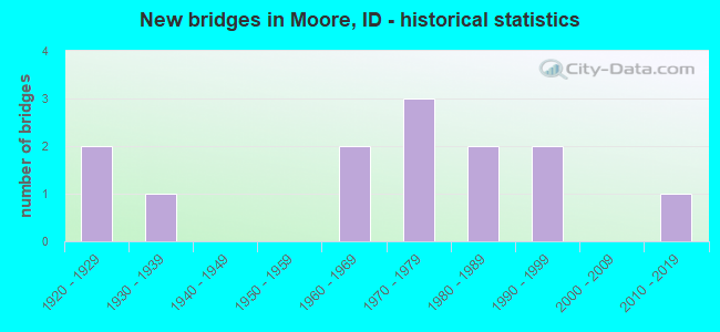
- New bridges - historical statistics
- 21920-1929
- 11930-1939
- 21960-1969
- 31970-1979
- 21980-1989
- 21990-1999
- 12010-2019

- Reconstructed bridges - Historical Statistics
- 31980-1989
- 21990-1999


- Bridge Condition - Deck
- 7.7%Very good
- 53.8%Good
- 38.5%Satisfactory

- Bridge Condition - Superstructure
- 23.1%Very good
- 38.5%Good
- 38.5%Satisfactory

- Bridge Condition - Substructure
- 15.4%Very good
- 7.7%Good
- 53.8%Satisfactory
- 23.1%Fair

- Bridge Condition - Channel
- 7.7%Very good
- 38.5%Good
- 46.2%Satisfactory
- 7.7%Fair
Find on map >> Show street view
Structure Number: 17965, Location: 0.9 S. MOORE (Lat: 43.720389, Lng: -113.357306), Route carried "on" structure: US 93, Year Built: 1962, Status: Open, Structure Length: 1.95m (6.40ft), Average Daily Traffic: 2,000 (year 2019), Truck Traffic: 16%, Average Future Daily Traffic: 3,000 (year 2039), Design Load: HS 20, Features Intersected: BIG LOST RIVER
Minimum Vertical Clearance: 30+ m (98+ ft), Kilometerpoint: 143.411, Lanes on structure: 2, Base Highway Network: Yes (Inventory Route: US0, Subroute: 1), Owner: State Highway Agency, Approaching Roadway Width: 10.4m (34.1ft), Material/Design: Concrete, Design/Construction: Stringer/Multi-beam, Number Of Spans In Main Unit: 2, Length of Maximum Span: 9.4m (30.8ft), Curb-To-Curb Width: 10.4m (34.1ft), Out-to-Out Width: 11.0m (36.1ft)
Condition: Deck: Good, Superstructure: Satisfactory, Substructure: Satisfactory, Channel: Satisfactory, Operating Rating: 67.1 metric tons, Method Used To Determine Operating Rating: Load Factor (LF), Inventory Rating: 39.9 metric tons, Method Used To Determine Inventory Rating: Load Factor (LF), Structural Evaluation: Equal to present minimum criteria, Deck Geometry: Equal to present minimum criteria, Waterway Adequacy: Equal to present desirable criteria, Approach Roadway Alignment: Equal to present desirable criteria, Designated Inspection Frequency: Every 48 months, Inspection Date: October 2019, Deck Structure Type: Concrete Cast-file-Place, Wearing Surface/Protective System: Wearing Surface: Latex Concrete
Find on map >> Show street view
Structure Number: 31435, Location: 0.2 N. 0.4 E. MOORE (Lat: 43.736250, Lng: -113.358639), Route carried "on" structure: County highway , Year Built: 1935, Year Reconstructed: 1989, Status: Open, Structure Length: 1.16m (3.81ft), Average Daily Traffic: 200 (year 2019), Truck Traffic: 10%, Average Future Daily Traffic: 300 (year 2039), Design Load: HS 20, Features Intersected: BIG LOST RIVER, Facility Carried by Structure: 3175 NORTH
Minimum Vertical Clearance: 30+ m (98+ ft), Kilometerpoint: 161.557, Lanes on structure: 2, Owner: County Highway Agency, Approaching Roadway Width: 6.1m (20.0ft), Material/Design: Prestressed concrete, Design/Construction: Tee Beam, Number Of Spans In Main Unit: 1, Length of Maximum Span: 11.0m (36.1ft), Curb or Sidewalk Widths: Left: 0.3m (1.0ft), Right: 0.3m (1.0ft), Curb-To-Curb Width: 7.0m (23.0ft), Out-to-Out Width: 7.6m (24.9ft)
Condition: Deck: Good, Superstructure: Good, Substructure: Satisfactory, Channel: Satisfactory, Operating Rating: 56.7 metric tons, Method Used To Determine Operating Rating: Allowable Stress (AS), Inventory Rating: 36.9 metric tons, Method Used To Determine Inventory Rating: Allowable Stress (AS), Structural Evaluation: Equal to present minimum criteria, Deck Geometry: Meets minimum limits, Waterway Adequacy: Equal to present desirable criteria, Approach Roadway Alignment: Equal to present desirable criteria, Designated Inspection Frequency: Every 24 months, Inspection Date: July 2021, Deck Structure Type: Concrete Cast-file-Place, Wearing Surface/Protective System: Wearing Surface: Bituminous
Find on map >> Show street view
Structure Number: 31456, Location: 1.6 S. 0.6 E. MOORE (Lat: 43.710806, Lng: -113.353472), Route carried "on" structure: County highway , Year Built: 1992, Status: Open, Structure Length: 1.19m (3.90ft), Average Daily Traffic: 50 (year 2019), Truck Traffic: 20%, Average Future Daily Traffic: 75 (year 2039), Design Load: HS 20, Features Intersected: E.BRANCH BIG LOST RIVER, Facility Carried by Structure: 3000N
Minimum Vertical Clearance: 30+ m (98+ ft), Kilometerpoint: 162.761, Lanes on structure: 2, Owner: County Highway Agency, Approaching Roadway Width: 6.1m (20.0ft), Material/Design: Prestressed concrete, Design/Construction: Tee Beam, Number Of Spans In Main Unit: 1, Length of Maximum Span: 11.6m (38.1ft), Curb-To-Curb Width: 7.3m (24.0ft), Out-to-Out Width: 7.9m (25.9ft)
Condition: Deck: Satisfactory, Superstructure: Good, Substructure: Good, Channel: Satisfactory, Operating Rating: 47.2 metric tons, Method Used To Determine Operating Rating: Field evaluation and documented engineering judgment, Inventory Rating: 28.1 metric tons, Method Used To Determine Inventory Rating: Field evaluation and documented engineering judgment, Structural Evaluation: Better than present minimum criteria, Deck Geometry: Equal to present minimum criteria, Waterway Adequacy: Better than present minimum criteria, Approach Roadway Alignment: Equal to present desirable criteria, Designated Inspection Frequency: Every 24 months, Inspection Date: July 2020, Deck Structure Type: Concrete Cast-file-Place, Wearing Surface/Protective System: Wearing Surface: Monolithic Concrete
Find on map >> Show street view
Structure Number: 3146, Location: 2.3 N. 0.2 E. MOORE (Lat: 43.768806, Lng: -113.361667), Route carried "on" structure: County highway , Year Built: 1979, Status: Open, Structure Length: 0.88m (2.89ft), Average Daily Traffic: 80 (year 2019), Truck Traffic: 13%, Average Future Daily Traffic: 120 (year 2039), Design Load: HS 20, Features Intersected: MOORE CANAL, Facility Carried by Structure: 3400 NORTH ROAD
Minimum Vertical Clearance: 30+ m (98+ ft), Kilometerpoint: 162.858, Lanes on structure: 2, Owner: County Highway Agency, Approaching Roadway Width: 6.1m (20.0ft), Skew: 3 degrees, Material/Design: Prestressed concrete, Design/Construction: Tee Beam, Number Of Spans In Main Unit: 1, Length of Maximum Span: 8.2m (26.9ft), Curb or Sidewalk Widths: Left: 0.2m (0.7ft), Right: 0.2m (0.7ft), Curb-To-Curb Width: 7.0m (23.0ft), Out-to-Out Width: 7.3m (24.0ft)
Condition: Deck: Satisfactory, Superstructure: Satisfactory, Substructure: Satisfactory, Channel: Good, Operating Rating: 44.1 metric tons, Method Used To Determine Operating Rating: Allowable Stress (AS), Inventory Rating: 27.9 metric tons, Method Used To Determine Inventory Rating: Allowable Stress (AS), Structural Evaluation: Equal to present minimum criteria, Deck Geometry: Somewhat better than minimum adequacy, Waterway Adequacy: Better than present minimum criteria, Approach Roadway Alignment: Equal to present desirable criteria, Designated Inspection Frequency: Every 24 months, Inspection Date: April 2021, Deck Structure Type: Concrete Cast-file-Place, Wearing Surface/Protective System: Wearing Surface: Monolithic Concrete
Find on map >> Show street view
Structure Number: 31465, Location: 1.4 N. MOORE (Lat: 43.757278, Lng: -113.366250), Route carried "on" structure: County highway , Year Built: 1979, Status: Open, Structure Length: 0.85m (2.79ft), Average Daily Traffic: 200 (year 2019), Truck Traffic: 10%, Average Future Daily Traffic: 300 (year 2039), Design Load: HS 20, Features Intersected: MOORE CANAL, Facility Carried by Structure: 3350 WEST ROAD
Minimum Vertical Clearance: 30+ m (98+ ft), Kilometerpoint: 163.323, Lanes on structure: 2, Owner: County Highway Agency, Approaching Roadway Width: 7.3m (24.0ft), Material/Design: Prestressed concrete, Design/Construction: Tee Beam, Number Of Spans In Main Unit: 1, Length of Maximum Span: 8.2m (26.9ft), Curb or Sidewalk Widths: Left: 0.2m (0.7ft), Right: 0.2m (0.7ft), Curb-To-Curb Width: 8.0m (26.2ft), Out-to-Out Width: 8.5m (27.9ft)
Condition: Deck: Satisfactory, Superstructure: Satisfactory, Substructure: Fair, Channel: Fair, Operating Rating: 49.5 metric tons, Method Used To Determine Operating Rating: Allowable Stress (AS), Inventory Rating: 32.4 metric tons, Method Used To Determine Inventory Rating: Allowable Stress (AS), Structural Evaluation: Somewhat better than minimum adequacy, Deck Geometry: Somewhat better than minimum adequacy, Waterway Adequacy: Better than present minimum criteria, Approach Roadway Alignment: Equal to present desirable criteria, Designated Inspection Frequency: Every 24 months, Inspection Date: April 2021, Deck Structure Type: Concrete Cast-file-Place, Wearing Surface/Protective System: Wearing Surface: Bituminous
Find on map >> Show street view
Structure Number: 31475, Location: 3.1 N. 2.2 W. ARCO (Lat: 43.681750, Lng: -113.344250), Route carried "on" structure: County highway , Year Built: 1920, Year Reconstructed: 1991, Status: Open, Structure Length: 1.62m (5.31ft), Average Daily Traffic: 40 (year 2019), Truck Traffic: 25%, Average Future Daily Traffic: 60 (year 2039), Design Load: H 15, Features Intersected: E.BRANCH BIG LOST RIVER, Facility Carried by Structure: 2800 N
Minimum Vertical Clearance: 30+ m (98+ ft), Kilometerpoint: 163.109, Lanes on structure: 2, Owner: County Highway Agency, Approaching Roadway Width: 6.1m (20.0ft), Material/Design: Prestressed concrete, Design/Construction: Tee Beam, Number Of Spans In Main Unit: 1, Length of Maximum Span: 14.9m (48.9ft), Curb-To-Curb Width: 6.7m (22.0ft), Out-to-Out Width: 7.3m (24.0ft)
Condition: Deck: Satisfactory, Superstructure: Very good, Substructure: Satisfactory, Channel: Good, Operating Rating: 54.4 metric tons, Method Used To Determine Operating Rating: Field evaluation and documented engineering judgment, Inventory Rating: 32.7 metric tons, Method Used To Determine Inventory Rating: Field evaluation and documented engineering judgment, Structural Evaluation: Equal to present minimum criteria, Deck Geometry: Somewhat better than minimum adequacy, Waterway Adequacy: Equal to present desirable criteria, Approach Roadway Alignment: Equal to present desirable criteria, Length Of Structure Improvement: 2.19m (7.19ft), Designated Inspection Frequency: Every 24 months, Inspection Date: July 2020, Bridge Improvement Cost: $333,000, Roadway Improvement Cost: $33,000, Total Project Cost: $499,000 ( Estimate for 2018), Deck Structure Type: Concrete Cast-file-Place
Find on map >> Show street view
Structure Number: 31481, Location: 1.3 N. 0.6 E. MOORE (Lat: 43.754306, Lng: -113.354667), Route carried "on" structure: County highway , Year Built: 1991, Status: Open, Structure Length: 2.07m (6.79ft), Average Daily Traffic: 50 (year 2019), Truck Traffic: 10%, Average Future Daily Traffic: 75 (year 2039), Design Load: HS 20, Features Intersected: BIG LOST RIVER, Facility Carried by Structure: 3300 N; SYVERIA LN
Minimum Vertical Clearance: 30+ m (98+ ft), Kilometerpoint: 161.874, Lanes on structure: 2, Owner: County Highway Agency, Approaching Roadway Width: 6.1m (20.0ft), Material/Design: Prestressed concrete, Design/Construction: Stringer/Multi-beam, Number Of Spans In Main Unit: 1, Length of Maximum Span: 20.1m (65.9ft), Curb-To-Curb Width: 8.1m (26.6ft), Out-to-Out Width: 9.1m (29.9ft)
Condition: Deck: Satisfactory, Superstructure: Very good, Substructure: Very good, Channel: Satisfactory, Operating Rating: 55.8 metric tons, Method Used To Determine Operating Rating: Load Factor (LF), Inventory Rating: 44.1 metric tons, Method Used To Determine Inventory Rating: Load Factor (LF), Structural Evaluation: Equal to present desirable criteria, Waterway Adequacy: Equal to present desirable criteria, Approach Roadway Alignment: Equal to present desirable criteria, Designated Inspection Frequency: Every 48 months, Inspection Date: July 2019, Deck Structure Type: Concrete Cast-file-Place, Wearing Surface/Protective System: Wearing Surface: Monolithic Concrete, Deck Protection: Epoxy Coated Reinforcing
Find on map >> Show street view
Structure Number: 31486, Location: 2.3 N 0.5 E MOORE (Lat: 43.768833, Lng: -113.356528), Route carried "on" structure: County highway , Year Built: 2010, Status: Open, Structure Length: 3.87m (12.70ft), Average Daily Traffic: 80 (year 2019), Truck Traffic: 13%, Average Future Daily Traffic: 120 (year 2039), Design Load: HL 93, Features Intersected: BIG LOST RIVER, Facility Carried by Structure: KNIGHTON LN;3350 N
Minimum Vertical Clearance: 30+ m (98+ ft), Kilometerpoint: 163.270, Lanes on structure: 2, Owner: County Highway Agency, Approaching Roadway Width: 8.8m (28.9ft), Skew: 4 degrees, Material/Design: Prestressed concrete, Design/Construction: Stringer/Multi-beam, Number Of Spans In Main Unit: 1, Length of Maximum Span: 36.6m (120.1ft), Curb-To-Curb Width: 8.5m (27.9ft), Out-to-Out Width: 9.4m (30.8ft)
Condition: Deck: Very good, Superstructure: Very good, Substructure: Very good, Channel: Very good, Operating Rating: 66.1 metric tons, Method Used To Determine Operating Rating: Load and Resistance Factor Rating (LRFR) rating reported by rating factor(RF) method using HL-93 loadings, Inventory Rating: 30.8 metric tons, Method Used To Determine Inventory Rating: Load and Resistance Factor Rating (LRFR) rating reported by rating factor(RF) method using HL-93 loadings, Structural Evaluation: Better than present minimum criteria, Deck Geometry: Better than present minimum criteria, Waterway Adequacy: Superior to present desirable criteria, Approach Roadway Alignment: Better than present minimum criteria, Designated Inspection Frequency: Every 48 months, Inspection Date: July 2021, Deck Structure Type: Concrete Cast-file-Place, Wearing Surface/Protective System: Wearing Surface: Monolithic Concrete, Deck Protection: Epoxy Coated Reinforcing
Find on map >> Show street view
Structure Number: 31495, Location: 0.4 S. 0.3 E. MOORE (Lat: 43.729139, Lng: -113.359639), Route carried "on" structure: County highway , Year Built: 1979, Year Reconstructed: 1993, Status: Open, Structure Length: 1.43m (4.69ft), Average Daily Traffic: 20 (year 2019), Truck Traffic: 50%, Average Future Daily Traffic: 30 (year 2039), Design Load: HS 20, Features Intersected: BIG LOST RIVER, Facility Carried by Structure: 3120 N
Minimum Vertical Clearance: 30+ m (98+ ft), Kilometerpoint: 162.778, Lanes on structure: 2, Owner: County Highway Agency, Approaching Roadway Width: 6.1m (20.0ft), Material/Design: Steel, Design/Construction: Stringer/Multi-beam, Number Of Spans In Main Unit: 1, Length of Maximum Span: 14.0m (45.9ft), Curb-To-Curb Width: 7.3m (24.0ft), Out-to-Out Width: 7.3m (24.0ft)
Condition: Deck: Good, Superstructure: Good, Substructure: Satisfactory, Channel: Good, Operating Rating: 46.3 metric tons, Method Used To Determine Operating Rating: Load Factor (LF), Inventory Rating: 27.2 metric tons, Method Used To Determine Inventory Rating: Load Factor (LF), Structural Evaluation: Equal to present minimum criteria, Deck Geometry: Equal to present minimum criteria, Waterway Adequacy: Equal to present desirable criteria, Approach Roadway Alignment: Equal to present desirable criteria, Designated Inspection Frequency: Every 24 months, Inspection Date: July 2021, Deck Structure Type: Corrugated Steel, Wearing Surface/Protective System: Wearing Surface: Bituminous
Find on map >> Show street view
Structure Number: 315, Location: 2.1 N. 3.3 W. ARCO (Lat: 43.667278, Lng: -113.365250), Route carried "on" structure: County highway , Year Built: 1984, Year Reconstructed: 1990, Status: Open, Structure Length: 0.91m (2.99ft), Average Daily Traffic: 90 (year 2019), Truck Traffic: 22%, Average Future Daily Traffic: 135 (year 2039), Design Load: HS 20, Features Intersected: BIG LOST RIVER, Facility Carried by Structure: 2700 N
Minimum Vertical Clearance: 30+ m (98+ ft), Kilometerpoint: 163.810, Lanes on structure: 2, Owner: County Highway Agency, Approaching Roadway Width: 6.1m (20.0ft), Material/Design: Prestressed concrete, Design/Construction: Tee Beam, Number Of Spans In Main Unit: 1, Length of Maximum Span: 8.8m (28.9ft), Curb or Sidewalk Widths: Left: 0.2m (0.7ft), Right: 0.2m (0.7ft), Curb-To-Curb Width: 8.1m (26.6ft), Out-to-Out Width: 8.5m (27.9ft)
Condition: Deck: Good, Superstructure: Satisfactory, Substructure: Fair, Channel: Good, Operating Rating: 47.7 metric tons, Method Used To Determine Operating Rating: Allowable Stress (AS), Inventory Rating: 34.2 metric tons, Method Used To Determine Inventory Rating: Allowable Stress (AS), Structural Evaluation: Somewhat better than minimum adequacy, Deck Geometry: Equal to present minimum criteria, Waterway Adequacy: Equal to present desirable criteria, Approach Roadway Alignment: Equal to present desirable criteria, Designated Inspection Frequency: Every 24 months, Inspection Date: July 2021, Deck Structure Type: Concrete Cast-file-Place, Wearing Surface/Protective System: Wearing Surface: Bituminous
Find on map >> Show street view
Structure Number: 3153, Location: 2.7 S. 0.8 E. MOORE (Lat: 43.696250, Lng: -113.348833), Route carried "on" structure: County highway , Year Built: 1920, Year Reconstructed: 1990, Status: Open, Structure Length: 1.58m (5.18ft), Average Daily Traffic: 150 (year 2019), Truck Traffic: 13%, Average Future Daily Traffic: 225 (year 2039), Design Load: HS 20, Features Intersected: E.BRANCH BIG LOST RIVER, Facility Carried by Structure: 2900N
Minimum Vertical Clearance: 30+ m (98+ ft), Kilometerpoint: 171.250, Lanes on structure: 2, Owner: County Highway Agency, Approaching Roadway Width: 6.1m (20.0ft), Material/Design: Prestressed concrete, Design/Construction: Tee Beam, Number Of Spans In Main Unit: 1, Length of Maximum Span: 15.2m (49.9ft), Curb or Sidewalk Widths: Left: 0.2m (0.7ft), Right: 0.2m (0.7ft), Curb-To-Curb Width: 6.8m (22.3ft), Out-to-Out Width: 7.3m (24.0ft)
Condition: Deck: Good, Superstructure: Good, Substructure: Satisfactory, Channel: Good, Operating Rating: 37.8 metric tons, Method Used To Determine Operating Rating: Allowable Stress (AS), Inventory Rating: 27.0 metric tons, Method Used To Determine Inventory Rating: Allowable Stress (AS), Structural Evaluation: Equal to present minimum criteria, Deck Geometry: Meets minimum limits, Waterway Adequacy: Equal to present desirable criteria, Approach Roadway Alignment: Equal to present desirable criteria, Designated Inspection Frequency: Every 24 months, Inspection Date: July 2020, Deck Structure Type: Concrete Cast-file-Place, Wearing Surface/Protective System: Wearing Surface: Bituminous
Find on map >> Show street view
Structure Number: 31535, Location: 2.7 S. 1.1 E. MOORE (Lat: 43.696250, Lng: -113.343500), Route carried "on" structure: County highway , Year Built: 1963, Status: Open, Structure Length: 0.70m (2.30ft), Average Daily Traffic: 150 (year 2019), Truck Traffic: 13%, Average Future Daily Traffic: 225 (year 2039), Design Load: HS 20, Features Intersected: EAST SIDE CANAL, Facility Carried by Structure: 2900 NORTH ROAD
Minimum Vertical Clearance: 30+ m (98+ ft), Kilometerpoint: 171.677, Lanes on structure: 2, Owner: County Highway Agency, Approaching Roadway Width: 7.3m (24.0ft), Skew: 3 degrees, Material/Design: Concrete, Design/Construction: Frame, Number Of Spans In Main Unit: 1, Length of Maximum Span: 7.0m (23.0ft), Curb or Sidewalk Widths: Left: 0.2m (0.7ft), Right: 0.3m (1.0ft), Curb-To-Curb Width: 9.1m (29.9ft), Out-to-Out Width: 9.8m (32.2ft)
Condition: Deck: Good, Superstructure: Good, Substructure: Fair, Channel: Satisfactory, Operating Rating: 42.6 metric tons, Method Used To Determine Operating Rating: Load Factor (LF), Inventory Rating: 25.4 metric tons, Method Used To Determine Inventory Rating: Load Factor (LF), Structural Evaluation: Somewhat better than minimum adequacy, Deck Geometry: Equal to present minimum criteria, Waterway Adequacy: Equal to present desirable criteria, Approach Roadway Alignment: Better than present minimum criteria, Length Of Structure Improvement: 1.37m (4.49ft), Designated Inspection Frequency: Every 24 months, Inspection Date: April 2021, Bridge Improvement Cost: $208,000, Roadway Improvement Cost: $21,000, Total Project Cost: $312,000 ( Estimate for 2021), Deck Structure Type: Concrete Cast-file-Place, Wearing Surface/Protective System: Wearing Surface: Bituminous
Find on map >> Show street view
Structure Number: 31551, Location: IN MOORE (Lat: 43.736833, Lng: -113.363778), Route carried "on" structure: City street , Year Built: 1989, Status: Posted for load, Structure Length: 0.76m (2.49ft), Average Daily Traffic: 200 (year 2019), Truck Traffic: 10%, Average Future Daily Traffic: 300 (year 2039), Design Load: HS 20, Features Intersected: WEST SIDE CANAL, Facility Carried by Structure: 3175 NORTH
Minimum Vertical Clearance: 30+ m (98+ ft), Kilometerpoint: 161.126, Lanes on structure: 2, Owner: City or Municipal Highway Agency, Approaching Roadway Width: 6.1m (20.0ft), Skew: 2 degrees, Material/Design: Prestressed concrete, Design/Construction: Tee Beam, Number Of Spans In Main Unit: 1, Length of Maximum Span: 7.0m (23.0ft), Curb or Sidewalk Widths: Left: 0.3m (1.0ft), Right: 0.3m (1.0ft), Curb-To-Curb Width: 6.7m (22.0ft), Out-to-Out Width: 7.3m (24.0ft)
Condition: Deck: Good, Superstructure: Satisfactory, Substructure: Satisfactory, Channel: Satisfactory, Operating Rating: 30.8 metric tons, Method Used To Determine Operating Rating: Load Factor (LF), Inventory Rating: 18.1 metric tons, Method Used To Determine Inventory Rating: Load Factor (LF), Structural Evaluation: Somewhat better than minimum adequacy, Deck Geometry: Meets minimum limits, Waterway Adequacy: Better than present minimum criteria, Approach Roadway Alignment: Better than present minimum criteria, Length Of Structure Improvement: 1.31m (4.30ft), Designated Inspection Frequency: Every 24 months, Inspection Date: April 2021, Bridge Improvement Cost: $199,000, Roadway Improvement Cost: $20,000, Total Project Cost: $299,000 ( Estimate for 2017), Deck Structure Type: Concrete Cast-file-Place, Wearing Surface/Protective System: Wearing Surface: Bituminous