Bridge Statistics for Moorland, Iowa (IA)
Condition, Traffic, Stress, Structural Evaluation, Project Costs
- National Bridge Inventory (NBI) Statistics
- 18Number of bridges
- 187ft / 56.8mTotal length
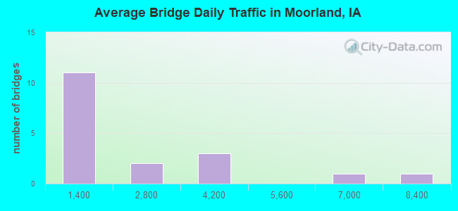
- 26,370Total average daily traffic
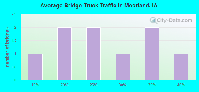
- 6,811Total average daily truck traffic
- National Bridge Inventory (NBI) Registered Bridges for Moorland
- No street view available for this location
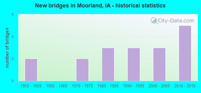
- New bridges - historical statistics
- 21950-1959
- 21970-1979
- 31980-1989
- 31990-1999
- 32000-2009
- 52010-2019
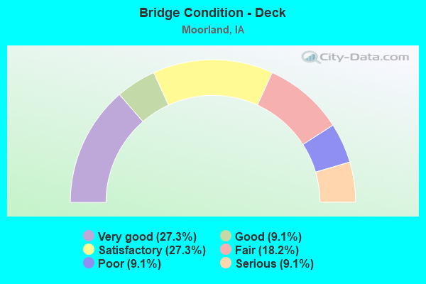
- Bridge Condition - Deck
- 27.3%Very good
- 9.1%Good
- 27.3%Satisfactory
- 18.2%Fair
- 9.1%Poor
- 9.1%Serious
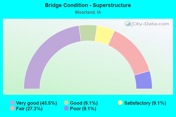
- Bridge Condition - Superstructure
- 45.5%Very good
- 9.1%Good
- 9.1%Satisfactory
- 27.3%Fair
- 9.1%Poor
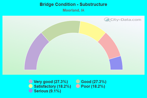
- Bridge Condition - Substructure
- 27.3%Very good
- 27.3%Good
- 18.2%Satisfactory
- 18.2%Poor
- 9.1%Serious
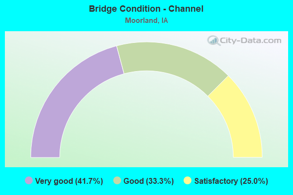
- Bridge Condition - Channel
- 41.7%Very good
- 33.3%Good
- 25.0%Satisfactory
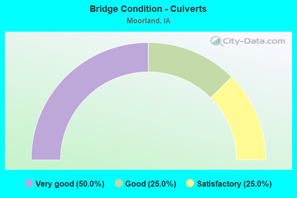
- Bridge Condition - Culverts
- 50.0%Very good
- 25.0%Good
- 25.0%Satisfactory
Find on map >> Show street view
Structure Number: 52031, Location: 088301401 (Lat: 42.432719, Lng: -94.318014), Route carried "on" structure: County highway , Year Built: 1984, Status: Open, Structure Length: 0.64m (2.10ft), Average Daily Traffic: 1,550 (year 2019), Truck Traffic: 21%, Average Future Daily Traffic: 1,550 (year 2038), Design Load: HS 20, Features Intersected: SPRING CREEK, Facility Carried by Structure: D 36
Minimum Vertical Clearance: 30+ m (98+ ft), Kilometerpoint: 7.606, Lanes on structure: 2, Owner: County Highway Agency, Approaching Roadway Width: 13.4m (44.0ft), Material/Design: Concrete continuous, Design/Construction: Culvert, Number Of Spans In Main Unit: 2, Length of Maximum Span: 3.0m (9.8ft), Curb-To-Curb Width: 13.4m (44.0ft), Out-to-Out Width: 13.4m (44.0ft)
Condition: Channel: Good, Culverts: Satisfactory, Operating Rating: 44.1 metric tons, Method Used To Determine Operating Rating: Assigned rating based on Load Factor Design (LFD) reported in metric tons, Inventory Rating: 32.7 metric tons, Method Used To Determine Inventory Rating: Assigned rating based on Load Factor Design (LFD) reported in metric tons, Structural Evaluation: Equal to present minimum criteria, Deck Geometry: Equal to present desirable criteria, Waterway Adequacy: Better than present minimum criteria, Approach Roadway Alignment: Superior to present desirable criteria, Designated Inspection Frequency: Every 48 months, Inspection Date: November 2018
Find on map >> Show street view
Structure Number: 52041, Location: 088301401 (Lat: 42.437161, Lng: -94.308344), Route carried "on" structure: City street , Year Built: 1984, Status: Open, Structure Length: 2.99m (9.81ft), Average Daily Traffic: 1,550 (year 2019), Average Future Daily Traffic: 1,550 (year 2041), Design Load: HS 20, Features Intersected: DRAINAGE DITCH, Facility Carried by Structure: HWY 20
Minimum Vertical Clearance: 30+ m (98+ ft), Kilometerpoint: 0.169, Lanes on structure: 2, Owner: County Highway Agency, Approaching Roadway Width: 13.4m (44.0ft), Skew: 2 degrees, Material/Design: Prestressed concrete, Design/Construction: Stringer/Multi-beam, Number Of Spans In Main Unit: 1, Length of Maximum Span: 29.0m (95.1ft), Curb-To-Curb Width: 13.4m (44.0ft), Out-to-Out Width: 14.4m (47.2ft)
Condition: Deck: Satisfactory, Superstructure: Very good, Substructure: Good, Channel: Very good, Operating Rating: 81.8 metric tons, Method Used To Determine Operating Rating: Load Factor (LF), Inventory Rating: 30.5 metric tons, Method Used To Determine Inventory Rating: Load Factor (LF), Structural Evaluation: Better than present minimum criteria, Deck Geometry: Equal to present desirable criteria, Waterway Adequacy: Equal to present minimum criteria, Approach Roadway Alignment: Better than present minimum criteria, Designated Inspection Frequency: Every 24 months, Inspection Date: November 2021, Deck Structure Type: Concrete Cast-file-Place, Wearing Surface/Protective System: Wearing Surface: Monolithic Concrete, Deck Protection: Epoxy Coated Reinforcing
Find on map >> Show street view
Structure Number: 342681, Location: 088290601 (Lat: 42.472994, Lng: -94.269425), Route carried "on" structure: County highway , Year Built: 1996, Status: Open, Structure Length: 2.38m (7.81ft), Average Daily Traffic: 70 (year 2015), Average Future Daily Traffic: 70 (year 2039), Design Load: HS 20, Features Intersected: SPRING CREEK, Facility Carried by Structure: LOCAL
Minimum Vertical Clearance: 30+ m (98+ ft), Kilometerpoint: 12.659, Lanes on structure: 2, Owner: County Highway Agency, Approaching Roadway Width: 9.1m (29.9ft), Skew: 1 degrees, Material/Design: Concrete continuous, Design/Construction: Slab, Number Of Spans In Main Unit: 3, Length of Maximum Span: 8.8m (28.9ft), Curb-To-Curb Width: 7.5m (24.6ft), Out-to-Out Width: 8.3m (27.2ft)
Condition: Deck: Very good, Superstructure: Very good, Substructure: Good, Channel: Satisfactory, Operating Rating: 76.1 metric tons, Method Used To Determine Operating Rating: Load Factor (LF), Inventory Rating: 45.5 metric tons, Method Used To Determine Inventory Rating: Load Factor (LF), Structural Evaluation: Better than present minimum criteria, Deck Geometry: Equal to present minimum criteria, Waterway Adequacy: Better than present minimum criteria, Approach Roadway Alignment: Equal to present minimum criteria, Length Of Structure Improvement: 7.80m (25.59ft), Designated Inspection Frequency: Every 48 months, Inspection Date: November 2019, Bridge Improvement Cost: $15,000, Roadway Improvement Cost: $2,000, Deck Structure Type: Concrete Cast-file-Place, Wearing Surface/Protective System: Wearing Surface: Monolithic Concrete
Find on map >> Show street view
Structure Number: 342811, Location: 088300104 (Lat: 42.459106, Lng: -94.290944), Route carried "on" structure: County highway , Year Built: 2019, Status: Open, Structure Length: 0.91m (2.99ft), Average Daily Traffic: 90 (year 2019), Average Future Daily Traffic: 90 (year 2041), Design Load: HL 93, Features Intersected: SPRING CREEK, Facility Carried by Structure: P33 GEORGE AVE
Minimum Vertical Clearance: 30+ m (98+ ft), Kilometerpoint: 0.340, Lanes on structure: 2, Owner: County Highway Agency, Approaching Roadway Width: 9.1m (29.9ft), Skew: 3 degrees, Material/Design: Concrete, Design/Construction: Culvert, Number Of Spans In Main Unit: 2, Length of Maximum Span: 4.3m (14.1ft)
Condition: Channel: Very good, Culverts: Very good, Operating Rating: 49.6 metric tons, Method Used To Determine Operating Rating: Load and Resistance Factor Rating (LRFR) rating reported by rating factor(RF) method using HL-93 loadings, Inventory Rating: 38.2 metric tons, Method Used To Determine Inventory Rating: Load and Resistance Factor Rating (LRFR) rating reported by rating factor(RF) method using HL-93 loadings, Structural Evaluation: Equal to present desirable criteria, Waterway Adequacy: Better than present minimum criteria, Approach Roadway Alignment: Better than present minimum criteria, Designated Inspection Frequency: Every 24 months, Inspection Date: November 2021
Find on map >> Show street view
Structure Number: 34282, Location: 088300302 (Lat: 42.470114, Lng: -94.339600), Route carried "on" structure: County highway , Year Built: 1956, Status: Posted for load, Structure Length: 0.76m (2.49ft), Average Daily Traffic: 35 (year 2015), Average Future Daily Traffic: 35 (year 2041), Features Intersected: FULTON TWP, Facility Carried by Structure: LOCAL
Minimum Vertical Clearance: 30+ m (98+ ft), Kilometerpoint: 27.325, Lanes on structure: 2, Owner: County Highway Agency, Approaching Roadway Width: 9.1m (29.9ft), Material/Design: Wood or Timber, Design/Construction: Stringer/Multi-beam, Number Of Spans In Main Unit: 1, Length of Maximum Span: 7.0m (23.0ft), Curb-To-Curb Width: 7.3m (24.0ft), Out-to-Out Width: 7.4m (24.3ft)
Condition: Deck: Fair, Superstructure: Fair, Substructure: Serious, Channel: Good, Operating Rating: 13.7 metric tons, Method Used To Determine Operating Rating: Allowable Stress (AS), Inventory Rating: 10.8 metric tons, Method Used To Determine Inventory Rating: Allowable Stress (AS), Structural Evaluation: High priority of corrective action, Deck Geometry: Equal to present minimum criteria, Waterway Adequacy: Equal to present desirable criteria, Approach Roadway Alignment: Equal to present desirable criteria, Bridge Posting: Required (Relationship of Operating Rating to Maximum Legal Load: > 39.9% below), Length Of Structure Improvement: 2.50m (8.20ft), Designated Inspection Frequency: Every 12 months, Inspection Date: November 2021, Bridge Improvement Cost: $15,000, Roadway Improvement Cost: $2,000, Deck Structure Type: Wood or Timber, Wearing Surface/Protective System: Wearing Surface: Wood or Timber
Find on map >> Show street view
Structure Number: 342871, Location: 088301101 (Lat: 42.455819, Lng: -94.314633), Route carried "on" structure: County highway , Year Built: 1974, Status: Open, Structure Length: 2.38m (7.81ft), Average Daily Traffic: 340 (year 2019), Truck Traffic: 15%, Average Future Daily Traffic: 340 (year 2041), Design Load: H 20, Features Intersected: DD NO 69, Facility Carried by Structure: FM
Minimum Vertical Clearance: 30+ m (98+ ft), Kilometerpoint: 6.799, Lanes on structure: 2, Owner: County Highway Agency, Approaching Roadway Width: 9.8m (32.2ft), Skew: 3 degrees, Material/Design: Concrete continuous, Design/Construction: Slab, Number Of Spans In Main Unit: 3, Length of Maximum Span: 8.8m (28.9ft), Curb-To-Curb Width: 9.1m (29.9ft), Out-to-Out Width: 9.4m (30.8ft)
Condition: Deck: Fair, Superstructure: Fair, Substructure: Satisfactory, Channel: Good, Operating Rating: 52.4 metric tons, Method Used To Determine Operating Rating: Allowable Stress (AS), Inventory Rating: 33.0 metric tons, Method Used To Determine Inventory Rating: Allowable Stress (AS), Structural Evaluation: Somewhat better than minimum adequacy, Deck Geometry: Equal to present minimum criteria, Waterway Adequacy: Equal to present desirable criteria, Approach Roadway Alignment: Equal to present desirable criteria, Length Of Structure Improvement: 7.80m (25.59ft), Designated Inspection Frequency: Every 24 months, Inspection Date: November 2021, Bridge Improvement Cost: $15,000, Roadway Improvement Cost: $2,000, Deck Structure Type: Concrete Cast-file-Place, Wearing Surface/Protective System: Wearing Surface: Monolithic Concrete
Find on map >> Show street view
Structure Number: 342881, Location: 088301201 (Lat: 42.456025, Lng: -94.293667), Route carried "on" structure: County highway , Year Built: 1974, Status: Open, Structure Length: 3.14m (10.30ft), Average Daily Traffic: 340 (year 2019), Truck Traffic: 15%, Average Future Daily Traffic: 340 (year 2041), Design Load: H 20, Features Intersected: DD NO 69, Facility Carried by Structure: FM
Minimum Vertical Clearance: 30+ m (98+ ft), Kilometerpoint: 8.525, Lanes on structure: 2, Owner: County Highway Agency, Approaching Roadway Width: 9.1m (29.9ft), Skew: 1 degrees, Material/Design: Concrete continuous, Design/Construction: Slab, Number Of Spans In Main Unit: 3, Length of Maximum Span: 11.9m (39.0ft), Curb-To-Curb Width: 9.1m (29.9ft), Out-to-Out Width: 9.4m (30.8ft)
Condition: Deck: Poor, Superstructure: Poor, Substructure: Satisfactory, Channel: Satisfactory, Operating Rating: 49.8 metric tons, Method Used To Determine Operating Rating: Allowable Stress (AS), Inventory Rating: 30.0 metric tons, Method Used To Determine Inventory Rating: Allowable Stress (AS), Structural Evaluation: Meets minimum limits, Deck Geometry: Equal to present minimum criteria, Waterway Adequacy: Equal to present desirable criteria, Approach Roadway Alignment: Better than present minimum criteria, Length Of Structure Improvement: 10.30m (33.79ft), Designated Inspection Frequency: Every 24 months, Inspection Date: November 2021, Bridge Improvement Cost: $15,000, Roadway Improvement Cost: $2,000, Deck Structure Type: Concrete Cast-file-Place, Wearing Surface/Protective System: Wearing Surface: Monolithic Concrete
Find on map >> Show street view
Structure Number: 342891, Location: 088301401 (Lat: 42.441439, Lng: -94.302003), Route carried "on" structure: City street , Year Built: 2013, Status: Open, Structure Length: 0.88m (2.89ft), Average Daily Traffic: 80 (year 2007), Average Future Daily Traffic: 80 (year 2041), Design Load: HS 20, Features Intersected: DD, Facility Carried by Structure: 240TH ST
Minimum Vertical Clearance: 30+ m (98+ ft), Kilometerpoint: 0.159, Lanes on structure: 2, Owner: County Highway Agency, Approaching Roadway Width: 9.1m (29.9ft), Skew: 1 degrees, Material/Design: Concrete continuous, Design/Construction: Culvert, Number Of Spans In Main Unit: 2, Length of Maximum Span: 4.3m (14.1ft)
Condition: Channel: Very good, Culverts: Very good, Operating Rating: 44.1 metric tons, Method Used To Determine Operating Rating: Assigned rating based on Load Factor Design (LFD) reported in metric tons, Inventory Rating: 32.7 metric tons, Method Used To Determine Inventory Rating: Assigned rating based on Load Factor Design (LFD) reported in metric tons, Structural Evaluation: Equal to present desirable criteria, Waterway Adequacy: Equal to present desirable criteria, Approach Roadway Alignment: Better than present minimum criteria, Designated Inspection Frequency: Every 48 months, Inspection Date: November 2021
Find on map >> Show street view
Structure Number: 34339, Location: 089293105 (Lat: 42.483597, Lng: -94.306325), Route carried "on" structure: County highway , Year Built: 1956, Status: Open, Structure Length: 3.87m (12.70ft), Average Daily Traffic: 80 (year 2015), Average Future Daily Traffic: 80 (year 2041), Design Load: H 15, Features Intersected: SOUTH LIZARD CREEK, Facility Carried by Structure: LOCAL
Minimum Vertical Clearance: 30+ m (98+ ft), Kilometerpoint: 11.248, Lanes on structure: 2, Owner: County Highway Agency, Approaching Roadway Width: 9.1m (29.9ft), Skew: 3 degrees, Material/Design: Steel continuous, Design/Construction: Stringer/Multi-beam, Number Of Spans In Main Unit: 3, Length of Maximum Span: 14.9m (48.9ft), Curb-To-Curb Width: 7.3m (24.0ft), Out-to-Out Width: 7.9m (25.9ft)
Condition: Deck: Serious, Superstructure: Fair, Substructure: Poor, Channel: Satisfactory, Operating Rating: 29.6 metric tons, Method Used To Determine Operating Rating: Load Factor (LF), Inventory Rating: 17.7 metric tons, Method Used To Determine Inventory Rating: Load Factor (LF), Structural Evaluation: Meets minimum limits, Deck Geometry: Equal to present minimum criteria, Waterway Adequacy: Equal to present minimum criteria, Approach Roadway Alignment: Equal to present minimum criteria, Length Of Structure Improvement: 15.00m (49.21ft), Designated Inspection Frequency: Every 12 months, Inspection Date: November 2021, Bridge Improvement Cost: $396,000, Roadway Improvement Cost: $40,000, Deck Structure Type: Concrete Cast-file-Place, Wearing Surface/Protective System: Wearing Surface: Monolithic Concrete
Find on map >> Show street view
Structure Number: 343401, Location: 089293204 (Lat: 42.476122, Lng: -94.304900), Route carried "on" structure: County highway , Year Built: 2005, Status: Open, Structure Length: 3.90m (12.80ft), Average Daily Traffic: 70 (year 2019), Average Future Daily Traffic: 70 (year 2039), Design Load: HS 20, Features Intersected: SOUTH LIZARD CREEK, Facility Carried by Structure: HAYES AVE
Minimum Vertical Clearance: 30+ m (98+ ft), Kilometerpoint: 28.361, Lanes on structure: 2, Owner: County Highway Agency, Approaching Roadway Width: 8.5m (27.9ft), Skew: 1 degrees, Material/Design: Concrete continuous, Design/Construction: Slab, Number Of Spans In Main Unit: 3, Length of Maximum Span: 14.9m (48.9ft), Curb-To-Curb Width: 9.3m (30.5ft), Out-to-Out Width: 10.1m (33.1ft)
Condition: Deck: Very good, Superstructure: Very good, Substructure: Very good, Channel: Very good, Operating Rating: 88.5 metric tons, Method Used To Determine Operating Rating: Load Factor (LF), Inventory Rating: 52.9 metric tons, Method Used To Determine Inventory Rating: Load Factor (LF), Structural Evaluation: Equal to present desirable criteria, Deck Geometry: Better than present minimum criteria, Waterway Adequacy: Superior to present desirable criteria, Approach Roadway Alignment: Equal to present desirable criteria, Length Of Structure Improvement: 12.80m (41.99ft), Designated Inspection Frequency: Every 48 months, Inspection Date: November 2019, Bridge Improvement Cost: $15,000, Roadway Improvement Cost: $2,000, Deck Structure Type: Concrete Cast-file-Place, Wearing Surface/Protective System: Wearing Surface: Monolithic Concrete, Deck Protection: Epoxy Coated Reinforcing
Find on map >> Show street view
Structure Number: 36159, Location: 088302301 (Lat: 42.426928, Lng: -94.314664), Route carried "on" structure: County highway , Year Built: 1981, Status: Open, Structure Length: 1.77m (5.81ft), Average Daily Traffic: 35 (year 2019), Truck Traffic: 20%, Average Future Daily Traffic: 35 (year 2041), Design Load: H 20, Features Intersected: DRAINAGE DITCH NO 69, Facility Carried by Structure: FM
Minimum Vertical Clearance: 30+ m (98+ ft), Kilometerpoint: 6.809, Lanes on structure: 2, Owner: County Highway Agency, Approaching Roadway Width: 9.8m (32.2ft), Skew: 1 degrees, Material/Design: Steel, Design/Construction: Stringer/Multi-beam, Number Of Spans In Main Unit: 3, Length of Maximum Span: 7.3m (24.0ft), Curb-To-Curb Width: 9.1m (29.9ft), Out-to-Out Width: 9.8m (32.2ft)
Condition: Deck: Satisfactory, Superstructure: Satisfactory, Substructure: Poor, Channel: Good, Operating Rating: 55.4 metric tons, Method Used To Determine Operating Rating: Allowable Stress (AS), Inventory Rating: 37.3 metric tons, Method Used To Determine Inventory Rating: Allowable Stress (AS), Structural Evaluation: Meets minimum limits, Deck Geometry: Better than present minimum criteria, Waterway Adequacy: Better than present minimum criteria, Approach Roadway Alignment: Better than present minimum criteria, Length Of Structure Improvement: 5.80m (19.03ft), Designated Inspection Frequency: Every 24 months, Inspection Date: November 2021, Bridge Improvement Cost: $15,000, Roadway Improvement Cost: $2,000, Deck Structure Type: Concrete Cast-file-Place, Wearing Surface/Protective System: Wearing Surface: Monolithic Concrete
Find on map >> Show street view
Structure Number: 60607, Location: 0.5 mi E of jct SR D36 (Lat: 42.451817, Lng: -94.277700), Route carried "on" structure: US 20, Year Built: 1990, Status: Open, Structure Length: 12.50m (41.01ft), Average Daily Traffic: 2,950 (year 2020), Truck Traffic: 34%, Average Future Daily Traffic: 2,950 (year 2041), Design Load: HS 20, Features Intersected: SR D20 & UP RR
Minimum Vertical Clearance: 30+ m (98+ ft), Kilometerpoint: 176.951, Lanes on structure: 2, Lanes under structure: 2, Base Highway Network: Yes, Owner: State Highway Agency, Approaching Roadway Width: 13.4m (44.0ft), Skew: 4 degrees, Material/Design: Steel continuous, Design/Construction: Stringer/Multi-beam, Number Of Spans In Main Unit: 4, Length of Maximum Span: 38.1m (125.0ft), Curb-To-Curb Width: 13.4m (44.0ft), Out-to-Out Width: 14.4m (47.2ft)
Condition: Deck: Satisfactory, Superstructure: Good, Substructure: Good, Operating Rating: 56.2 metric tons, Method Used To Determine Operating Rating: Load Factor (LF), Inventory Rating: 33.6 metric tons, Method Used To Determine Inventory Rating: Load Factor (LF), Structural Evaluation: Better than present minimum criteria, Deck Geometry: Superior to present desirable criteria, Underclear: Better than present minimum criteria, Approach Roadway Alignment: Equal to present minimum criteria, Designated Inspection Frequency: Every 24 months, Inspection Date: June 2021, Deck Structure Type: Concrete Cast-file-Place, Wearing Surface/Protective System: Wearing Surface: Monolithic Concrete, Deck Protection: Epoxy Coated Reinforcing
Find on map >> Show street view
Structure Number: 609705, Location: At Jct. US 20 (Lat: 42.452181, Lng: -94.286633), Route carried "on" structure: County highway , Year Built: 2010, Status: Open, Structure Length: 7.35m (24.11ft), Average Daily Traffic: 3,180 (year 2019), Truck Traffic: 10%, Average Future Daily Traffic: 3,180 (year 2040), Design Load: HS 20, Features Intersected: US 20, Facility Carried by Structure: CO RD D 36
Minimum Vertical Clearance: 30+ m (98+ ft), Kilometerpoint: 0.373, Lanes on structure: 2, Lanes under structure: 4, Owner: State Highway Agency, Approaching Roadway Width: 13.4m (44.0ft), Material/Design: Prestressed concrete, Design/Construction: Stringer/Multi-beam, Number Of Spans In Main Unit: 2, Length of Maximum Span: 36.6m (120.1ft), Curb-To-Curb Width: 13.2m (43.3ft), Out-to-Out Width: 14.1m (46.3ft)
Condition: Deck: Very good, Superstructure: Very good, Substructure: Very good, Operating Rating: 84.9 metric tons, Method Used To Determine Operating Rating: Load Factor (LF), Inventory Rating: 30.9 metric tons, Method Used To Determine Inventory Rating: Load Factor (LF), Structural Evaluation: Better than present minimum criteria, Deck Geometry: Equal to present minimum criteria, Underclear: Meets minimum limits, Approach Roadway Alignment: Equal to present desirable criteria, Designated Inspection Frequency: Every 24 months, Inspection Date: June 2020, Deck Structure Type: Concrete Cast-file-Place, Wearing Surface/Protective System: Wearing Surface: Monolithic Concrete, Deck Protection: Epoxy Coated Reinforcing
Find on map >> Show street view
Structure Number: 60971, Location: 0.5 mi E of SR D36 (Lat: 42.451653, Lng: -94.275406), Route carried "on" structure: US 20, Year Built: 2008, Status: Open, Structure Length: 12.52m (41.08ft), Average Daily Traffic: 2,950 (year 2020), Truck Traffic: 34%, Average Future Daily Traffic: 2,950 (year 2040), Design Load: HL 93, Features Intersected: D 20 & UP RR
Minimum Vertical Clearance: 30+ m (98+ ft), Kilometerpoint: 306.043, Lanes on structure: 2, Lanes under structure: 2, Owner: State Highway Agency, Approaching Roadway Width: 12.0m (39.4ft), Skew: 4 degrees, Material/Design: Steel, Design/Construction: Stringer/Multi-beam, Number Of Spans In Main Unit: 4, Length of Maximum Span: 38.0m (124.7ft), Curb-To-Curb Width: 12.0m (39.4ft), Out-to-Out Width: 13.0m (42.7ft)
Condition: Deck: Good, Superstructure: Very good, Substructure: Very good, Operating Rating: 75.2 metric tons, Method Used To Determine Operating Rating: Load Factor (LF), Inventory Rating: 45.1 metric tons, Method Used To Determine Inventory Rating: Load Factor (LF), Structural Evaluation: Equal to present desirable criteria, Deck Geometry: Better than present minimum criteria, Underclear: Superior to present desirable criteria, Approach Roadway Alignment: Equal to present desirable criteria, Designated Inspection Frequency: Every 24 months, Inspection Date: June 2020, Deck Structure Type: Concrete Cast-file-Place, Wearing Surface/Protective System: Wearing Surface: Monolithic Concrete, Deck Protection: Epoxy Coated Reinforcing
Find on map >> Show street view
Structure Number: 609745, Location: 0.4 mi. W of SR D36 (Lat: 42.451433, Lng: -94.295728), Route carried "on" structure: US 20, Year Built: 2011, Status: Open, Structure Length: 0.79m (2.59ft), Average Daily Traffic: 7,100 (year 2020), Truck Traffic: 28%, Average Future Daily Traffic: 7,100 (year 2040), Design Load: HS 20, Features Intersected: DRAINAGE DITCH 69
Minimum Vertical Clearance: 30+ m (98+ ft), Kilometerpoint: 175.452, Lanes on structure: 4, Base Highway Network: Yes, Owner: State Highway Agency, Approaching Roadway Width: 12.0m (39.4ft), Skew: 22 degrees, Material/Design: Concrete continuous, Design/Construction: Culvert, Number Of Spans In Main Unit: 2, Length of Maximum Span: 4.0m (13.1ft)
Condition: Channel: Very good, Culverts: Good, Operating Rating: 42.7 metric tons, Method Used To Determine Operating Rating: Load Factor (LF), Inventory Rating: 25.6 metric tons, Method Used To Determine Inventory Rating: Load Factor (LF), Structural Evaluation: Equal to present minimum criteria, Waterway Adequacy: Superior to present desirable criteria, Approach Roadway Alignment: Equal to present desirable criteria, Designated Inspection Frequency: Every 24 months, Inspection Date: April 2020
Find on map >> Show street view
Structure Number: 60607, Location: 0.5 mi E of jct SR D36 (Lat: 42.451817, Lng: -94.277700), Route carried "under" structure: County highway , Year Built: 1990, Structure Length: 0. m, Average Daily Traffic: 25 (year 2015), Features Intersected: SR D20 & UP RR, Facility Carried by Structure: US 20 EB
Minimum Vertical Clearance: 30+ m (98+ ft), Kilometerpoint: 0.880, Lanes on structure: 2, Lanes under structure: 2, Material/Design: Steel continuous, Design/Construction: Stringer/Multi-beam, Length of Maximum Span: 38.1m (125.0ft)
Find on map >> Show street view
Structure Number: 609705, Location: At Jct. US 20 (Lat: 42.452181, Lng: -94.286633), Route carried "under" structure: US 20, Year Built: 2010, Structure Length: 0. m, Average Daily Traffic: 5,900 (year 2020), Truck Traffic: 35%, Features Intersected: US 20, Facility Carried by Structure: CO RD D 36
Minimum Vertical Clearance: 30+ m (98+ ft), Kilometerpoint: 176.212, Lanes on structure: 2, Lanes under structure: 4, Material/Design: Prestressed concrete, Design/Construction: Stringer/Multi-beam, Length of Maximum Span: 36.6m (120.1ft)
Find on map >> Show street view
Structure Number: 60971, Location: 0.5 mi E of SR D36 (Lat: 42.451653, Lng: -94.275406), Route carried "under" structure: County highway , Year Built: 2008, Structure Length: 0. m, Average Daily Traffic: 25 (year 2015), Features Intersected: D 20 & UP RR, Facility Carried by Structure: US 20 WB
Minimum Vertical Clearance: 30+ m (98+ ft), Kilometerpoint: 0.921, Lanes on structure: 2, Lanes under structure: 2, Material/Design: Steel, Design/Construction: Stringer/Multi-beam, Length of Maximum Span: 38.0m (124.7ft)