Bridge Statistics for Moundville, Wisconsin (WI)
Condition, Traffic, Stress, Structural Evaluation, Project Costs
- National Bridge Inventory (NBI) Statistics
- 19Number of bridges
- 148ft / 45.2mTotal length
- 154,519Total average daily traffic
- 23,927Total average daily truck traffic
- National Bridge Inventory (NBI) Registered Bridges for Moundville
- No street view available for this location
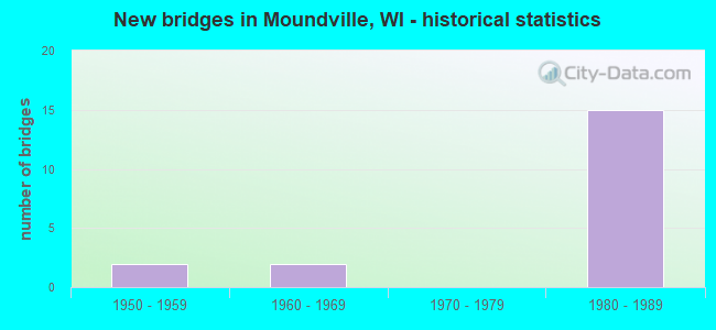
- New bridges - historical statistics
- 21950-1959
- 21960-1969
- 151980-1989

- Reconstructed bridges - Historical Statistics
- 21990-1999
- 12000-2009


- Bridge Condition - Deck
- 75.0%Good
- 16.7%Satisfactory
- 8.3%Fair

- Bridge Condition - Superstructure
- 33.3%Very good
- 58.3%Good
- 8.3%Satisfactory

- Bridge Condition - Substructure
- 83.3%Good
- 16.7%Satisfactory

- Bridge Condition - Channel
- 75.0%Very good
- 25.0%Fair
Find on map >> Show street view
Structure Number: B390004, Location: 4.0M N JCT CTH J (Lat: 43.915789, Lng: -89.312161), Route carried "on" structure: State highway 22, Year Built: 1951, Year Reconstructed: 1990, Status: Open, Structure Length: 2.23m (7.32ft), Average Daily Traffic: 1,700 (year 2019), Truck Traffic: 9%, Average Future Daily Traffic: 2,370 (year 2040), Design Load: H 15, Features Intersected: MECAN RIVER
Minimum Vertical Clearance: 30+ m (98+ ft), Kilometerpoint: 0.000, Lanes on structure: 2, Owner: State Highway Agency, Approaching Roadway Width: 11.0m (36.1ft), Material/Design: Steel, Design/Construction: Stringer/Multi-beam, Number Of Spans In Main Unit: 1, Length of Maximum Span: 21.8m (71.5ft), Curb-To-Curb Width: 8.7m (28.5ft), Out-to-Out Width: 9.3m (30.5ft)
Condition: Deck: Satisfactory, Superstructure: Good, Substructure: Good, Channel: Very good, Operating Rating: 50.6 metric tons, Method Used To Determine Operating Rating: Load Factor (LF), Inventory Rating: 30.8 metric tons, Method Used To Determine Inventory Rating: Load Factor (LF), Structural Evaluation: Better than present minimum criteria, Deck Geometry: Somewhat better than minimum adequacy, Waterway Adequacy: Equal to present desirable criteria, Approach Roadway Alignment: Equal to present desirable criteria, Designated Inspection Frequency: Every 24 months, Inspection Date: September 2021, Deck Structure Type: Concrete Cast-file-Place, Wearing Surface/Protective System: Wearing Surface: Epoxy Overlay, Deck Protection: Epoxy Coated Reinforcing
Find on map >> Show street view
Structure Number: B390006, Location: 1.8M S JCT CTH O (Lat: 43.644667, Lng: -89.470117), Route carried "on" structure: Interstate 39, Year Built: 1959, Year Reconstructed: 2004, Status: Open, Structure Length: 2.32m (7.61ft), Average Daily Traffic: 14,300 (year 2019), Truck Traffic: 18%, Average Future Daily Traffic: 10,935 (year 2039), Design Load: HS 20, Features Intersected: NEENAH CREEK
Minimum Vertical Clearance: 30+ m (98+ ft), Kilometerpoint: 0.000, Lanes on structure: 2, Base Highway Network: Yes, Owner: State Highway Agency, Approaching Roadway Width: 13.1m (43.0ft), Material/Design: Prestressed concrete, Design/Construction: Stringer/Multi-beam, Number Of Spans In Main Unit: 1, Length of Maximum Span: 21.9m (71.9ft), Curb-To-Curb Width: 13.4m (44.0ft), Out-to-Out Width: 14.0m (45.9ft)
Condition: Deck: Good, Superstructure: Very good, Substructure: Good, Channel: Very good, Operating Rating: 67.0 metric tons, Method Used To Determine Operating Rating: Load Factor (LF), Inventory Rating: 34.0 metric tons, Method Used To Determine Inventory Rating: Load Factor (LF), Structural Evaluation: Better than present minimum criteria, Deck Geometry: Superior to present desirable criteria, Waterway Adequacy: Equal to present desirable criteria, Approach Roadway Alignment: Equal to present desirable criteria, Designated Inspection Frequency: Every 24 months, Inspection Date: May 2020, Deck Structure Type: Concrete Cast-file-Place, Wearing Surface/Protective System: Wearing Surface: Epoxy Overlay, Deck Protection: Epoxy Coated Reinforcing
Find on map >> Show street view
Structure Number: B39001, Location: 2.3M S JCT CTH M (Lat: 43.816850, Lng: -89.482750), Route carried "on" structure: Interstate 39, Year Built: 1966, Status: Open, Structure Length: 3.10m (10.17ft), Average Daily Traffic: 10,800 (year 2019), Truck Traffic: 20%, Average Future Daily Traffic: 13,800 (year 2039), Design Load: HS 20, Features Intersected: LRD FAWN AVE
Minimum Vertical Clearance: 30+ m (98+ ft), Kilometerpoint: 0.000, Lanes on structure: 2, Lanes under structure: 2, Base Highway Network: Yes, Owner: State Highway Agency, Approaching Roadway Width: 13.4m (44.0ft), Material/Design: Concrete continuous, Design/Construction: Slab, Number Of Spans In Main Unit: 3, Length of Maximum Span: 12.6m (41.3ft), Curb or Sidewalk Widths: Left: 0.2m (0.7ft), Right: 0.2m (0.7ft), Curb-To-Curb Width: 13.1m (43.0ft), Out-to-Out Width: 14.0m (45.9ft)
Condition: Deck: Satisfactory, Superstructure: Satisfactory, Substructure: Satisfactory, Operating Rating: 47.4 metric tons, Method Used To Determine Operating Rating: Load Factor (LF), Inventory Rating: 27.5 metric tons, Method Used To Determine Inventory Rating: Load Factor (LF), Structural Evaluation: Equal to present minimum criteria, Deck Geometry: Superior to present desirable criteria, Underclear: Somewhat better than minimum adequacy, Approach Roadway Alignment: Equal to present desirable criteria, Designated Inspection Frequency: Every 24 months, Inspection Date: May 2020, Deck Structure Type: Concrete Cast-file-Place, Wearing Surface/Protective System: Wearing Surface: Epoxy Overlay
Find on map >> Show street view
Structure Number: B390012, Location: 0.4M S JCT USH 51 (Lat: 43.644558, Lng: -89.468239), Route carried "on" structure: County highway , Year Built: 1966, Status: Open, Structure Length: 2.04m (6.69ft), Average Daily Traffic: 1,340 (year 2018), Average Future Daily Traffic: 1,422 (year 2039), Design Load: H 20, Features Intersected: NEENAH CREEK, Facility Carried by Structure: CTH CX
Minimum Vertical Clearance: 30+ m (98+ ft), Kilometerpoint: 0.000, Lanes on structure: 2, Owner: County Highway Agency, Approaching Roadway Width: 11.6m (38.1ft), Material/Design: Prestressed concrete, Design/Construction: Stringer/Multi-beam, Number Of Spans In Main Unit: 1, Length of Maximum Span: 19.8m (65.0ft), Curb-To-Curb Width: 9.8m (32.2ft), Out-to-Out Width: 10.5m (34.4ft)
Condition: Deck: Fair, Superstructure: Good, Substructure: Satisfactory, Channel: Fair, Operating Rating: 49.0 metric tons, Method Used To Determine Operating Rating: Load Factor (LF), Inventory Rating: 21.1 metric tons, Method Used To Determine Inventory Rating: Load Factor (LF), Structural Evaluation: Somewhat better than minimum adequacy, Deck Geometry: Somewhat better than minimum adequacy, Waterway Adequacy: Equal to present desirable criteria, Approach Roadway Alignment: Equal to present desirable criteria, Designated Inspection Frequency: Every 24 months, Inspection Date: August 2020, Deck Structure Type: Concrete Cast-file-Place, Wearing Surface/Protective System: Wearing Surface: Monolithic Concrete
Find on map >> Show street view
Structure Number: B390015, Location: 4.8M N JCT STH 78 TO S (Lat: 43.644542, Lng: -89.469508), Route carried "on" structure: Interstate 39, Year Built: 1984, Status: Open, Structure Length: 2.26m (7.41ft), Average Daily Traffic: 16,100 (year 2019), Truck Traffic: 18%, Average Future Daily Traffic: 19,900 (year 2039), Design Load: HS 20, Features Intersected: NEENAH CREEK
Minimum Vertical Clearance: 30+ m (98+ ft), Kilometerpoint: 0.000, Lanes on structure: 2, Base Highway Network: Yes, Owner: State Highway Agency, Approaching Roadway Width: 12.2m (40.0ft), Material/Design: Prestressed concrete, Design/Construction: Stringer/Multi-beam, Number Of Spans In Main Unit: 1, Length of Maximum Span: 21.9m (71.9ft), Curb-To-Curb Width: 12.2m (40.0ft), Out-to-Out Width: 13.1m (43.0ft)
Condition: Deck: Good, Superstructure: Very good, Substructure: Good, Channel: Very good, Operating Rating: 63.7 metric tons, Method Used To Determine Operating Rating: Load Factor (LF), Inventory Rating: 30.8 metric tons, Method Used To Determine Inventory Rating: Load Factor (LF), Structural Evaluation: Better than present minimum criteria, Deck Geometry: Better than present minimum criteria, Waterway Adequacy: Equal to present desirable criteria, Approach Roadway Alignment: Equal to present desirable criteria, Designated Inspection Frequency: Every 24 months, Inspection Date: May 2020, Deck Structure Type: Concrete Cast-file-Place, Wearing Surface/Protective System: Wearing Surface: Epoxy Overlay, Deck Protection: Epoxy Coated Reinforcing
Find on map >> Show street view
Structure Number: B390016, Location: AT JCT USH 51 (Lat: 43.649742, Lng: -89.470644), Route carried "on" structure: City street , Year Built: 1984, Year Reconstructed: 2014, Status: Open, Structure Length: 7.38m (24.21ft), Average Daily Traffic: 120 (year 2019), Average Future Daily Traffic: 120 (year 2037), Design Load: HS 20, Features Intersected: IH USH 51-IH 39, Facility Carried by Structure: LRD GROUSE DRIVE
Minimum Vertical Clearance: 30+ m (98+ ft), Kilometerpoint: 0.000, Lanes on structure: 2, Lanes under structure: 4, Owner: State Highway Agency, Approaching Roadway Width: 10.4m (34.1ft), Material/Design: Steel continuous, Design/Construction: Stringer/Multi-beam, Number Of Spans In Main Unit: 2, Length of Maximum Span: 37.9m (124.3ft), Curb-To-Curb Width: 10.4m (34.1ft), Out-to-Out Width: 11.3m (37.1ft)
Condition: Deck: Good, Superstructure: Good, Substructure: Good, Operating Rating: 57.0 metric tons, Method Used To Determine Operating Rating: Load Factor (LF), Inventory Rating: 34.0 metric tons, Method Used To Determine Inventory Rating: Load Factor (LF), Structural Evaluation: Better than present minimum criteria, Deck Geometry: Better than present minimum criteria, Underclear: Equal to present minimum criteria, Approach Roadway Alignment: Equal to present desirable criteria, Designated Inspection Frequency: Every 48 months, Inspection Date: May 2018, Deck Structure Type: Concrete Cast-file-Place, Wearing Surface/Protective System: Wearing Surface: Monolithic Concrete, Deck Protection: Epoxy Coated Reinforcing
Find on map >> Show street view
Structure Number: B390017, Location: 6.7M N JCT STH 78 TO S (Lat: 43.671344, Lng: -89.469719), Route carried "on" structure: Interstate 39, Year Built: 1983, Status: Open, Structure Length: 3.54m (11.61ft), Average Daily Traffic: 16,100 (year 2019), Truck Traffic: 18%, Average Future Daily Traffic: 19,100 (year 2039), Design Load: HS 20, Features Intersected: CTH O
Minimum Vertical Clearance: 30+ m (98+ ft), Kilometerpoint: 0.000, Lanes on structure: 2, Lanes under structure: 2, Base Highway Network: Yes, Owner: State Highway Agency, Approaching Roadway Width: 12.2m (40.0ft), Material/Design: Concrete continuous, Design/Construction: Slab, Number Of Spans In Main Unit: 3, Length of Maximum Span: 16.6m (54.5ft), Curb-To-Curb Width: 12.2m (40.0ft), Out-to-Out Width: 13.1m (43.0ft)
Condition: Deck: Good, Superstructure: Good, Substructure: Good, Operating Rating: 52.3 metric tons, Method Used To Determine Operating Rating: Load Factor (LF), Inventory Rating: 30.8 metric tons, Method Used To Determine Inventory Rating: Load Factor (LF), Structural Evaluation: Better than present minimum criteria, Deck Geometry: Better than present minimum criteria, Underclear: Equal to present minimum criteria, Approach Roadway Alignment: Equal to present desirable criteria, Designated Inspection Frequency: Every 24 months, Inspection Date: May 2020, Deck Structure Type: Concrete Cast-file-Place, Wearing Surface/Protective System: Wearing Surface: Epoxy Overlay, Deck Protection: Epoxy Coated Reinforcing
Find on map >> Show street view
Structure Number: B390018, Location: 2.0M S JCT STH 23 (Lat: 43.671675, Lng: -89.470225), Route carried "on" structure: Interstate 39, Year Built: 1983, Status: Open, Structure Length: 3.54m (11.61ft), Average Daily Traffic: 14,300 (year 2019), Truck Traffic: 18%, Average Future Daily Traffic: 14,100 (year 2039), Design Load: HS 20, Features Intersected: CTH O
Minimum Vertical Clearance: 30+ m (98+ ft), Kilometerpoint: 0.000, Lanes on structure: 2, Lanes under structure: 2, Base Highway Network: Yes, Owner: State Highway Agency, Approaching Roadway Width: 12.2m (40.0ft), Material/Design: Concrete continuous, Design/Construction: Slab, Number Of Spans In Main Unit: 3, Length of Maximum Span: 16.6m (54.5ft), Curb-To-Curb Width: 12.2m (40.0ft), Out-to-Out Width: 13.1m (43.0ft)
Condition: Deck: Good, Superstructure: Good, Substructure: Good, Operating Rating: 52.3 metric tons, Method Used To Determine Operating Rating: Load Factor (LF), Inventory Rating: 30.8 metric tons, Method Used To Determine Inventory Rating: Load Factor (LF), Structural Evaluation: Better than present minimum criteria, Deck Geometry: Better than present minimum criteria, Underclear: Equal to present minimum criteria, Approach Roadway Alignment: Equal to present desirable criteria, Designated Inspection Frequency: Every 24 months, Inspection Date: May 2020, Deck Structure Type: Concrete Cast-file-Place, Wearing Surface/Protective System: Wearing Surface: Epoxy Overlay, Deck Protection: Epoxy Coated Reinforcing
Find on map >> Show street view
Structure Number: B390019, Location: 2.0M N JCT CTH O (Lat: 43.700942, Lng: -89.471047), Route carried "on" structure: Interstate 39, Year Built: 1984, Status: Open, Structure Length: 5.45m (17.88ft), Average Daily Traffic: 14,300 (year 2019), Truck Traffic: 18%, Average Future Daily Traffic: 14,100 (year 2039), Design Load: HS 20, Features Intersected: STH 23
Minimum Vertical Clearance: 30+ m (98+ ft), Kilometerpoint: 0.000, Lanes on structure: 2, Lanes under structure: 2, Base Highway Network: Yes, Owner: State Highway Agency, Approaching Roadway Width: 12.2m (40.0ft), Material/Design: Prestressed concrete continuous, Design/Construction: Stringer/Multi-beam, Number Of Spans In Main Unit: 2, Length of Maximum Span: 28.0m (91.9ft), Curb-To-Curb Width: 12.2m (40.0ft), Out-to-Out Width: 13.1m (43.0ft)
Condition: Deck: Good, Superstructure: Very good, Substructure: Good, Operating Rating: 55.5 metric tons, Method Used To Determine Operating Rating: Load Factor (LF), Inventory Rating: 32.4 metric tons, Method Used To Determine Inventory Rating: Load Factor (LF), Structural Evaluation: Better than present minimum criteria, Deck Geometry: Better than present minimum criteria, Underclear: Superior to present desirable criteria, Approach Roadway Alignment: Equal to present desirable criteria, Designated Inspection Frequency: Every 48 months, Inspection Date: May 2020, Deck Structure Type: Concrete Cast-file-Place, Wearing Surface/Protective System: Wearing Surface: Epoxy Overlay, Deck Protection: Epoxy Coated Reinforcing
Find on map >> Show street view
Structure Number: B39002, Location: 4.2M S JCT CTH D (Lat: 43.701425, Lng: -89.471650), Route carried "on" structure: Interstate 39, Year Built: 1984, Status: Open, Structure Length: 5.45m (17.88ft), Average Daily Traffic: 10,039 (year 2019), Truck Traffic: 18%, Average Future Daily Traffic: 11,042 (year 2039), Design Load: HS 20, Features Intersected: STH 23
Minimum Vertical Clearance: 30+ m (98+ ft), Kilometerpoint: 0.000, Lanes on structure: 2, Lanes under structure: 2, Base Highway Network: Yes, Owner: State Highway Agency, Approaching Roadway Width: 12.2m (40.0ft), Material/Design: Prestressed concrete continuous, Design/Construction: Stringer/Multi-beam, Number Of Spans In Main Unit: 2, Length of Maximum Span: 28.0m (91.9ft), Curb-To-Curb Width: 12.2m (40.0ft), Out-to-Out Width: 13.1m (43.0ft)
Condition: Deck: Good, Superstructure: Very good, Substructure: Good, Operating Rating: 52.3 metric tons, Method Used To Determine Operating Rating: Load Factor (LF), Inventory Rating: 34.0 metric tons, Method Used To Determine Inventory Rating: Load Factor (LF), Structural Evaluation: Better than present minimum criteria, Deck Geometry: Better than present minimum criteria, Underclear: Superior to present desirable criteria, Approach Roadway Alignment: Equal to present desirable criteria, Designated Inspection Frequency: Every 48 months, Inspection Date: May 2020, Deck Structure Type: Concrete Cast-file-Place, Wearing Surface/Protective System: Wearing Surface: Epoxy Overlay, Deck Protection: Epoxy Coated Reinforcing
Find on map >> Show street view
Structure Number: B390021, Location: 1.3M N JCT STH 23 TO W (Lat: 43.718489, Lng: -89.476936), Route carried "on" structure: Interstate 39, Year Built: 1984, Status: Open, Structure Length: 3.93m (12.89ft), Average Daily Traffic: 590 (year 2019), Truck Traffic: 18%, Average Future Daily Traffic: 14,100 (year 2039), Design Load: HS 20, Features Intersected: CTH CX
Minimum Vertical Clearance: 30+ m (98+ ft), Kilometerpoint: 0.000, Lanes on structure: 2, Lanes under structure: 2, Base Highway Network: Yes, Owner: State Highway Agency, Approaching Roadway Width: 12.2m (40.0ft), Skew: 2 degrees, Material/Design: Concrete continuous, Design/Construction: Slab, Number Of Spans In Main Unit: 3, Length of Maximum Span: 17.7m (58.1ft), Curb-To-Curb Width: 12.2m (40.0ft), Out-to-Out Width: 13.1m (43.0ft)
Condition: Deck: Good, Superstructure: Good, Substructure: Good, Operating Rating: 49.0 metric tons, Method Used To Determine Operating Rating: Load Factor (LF), Inventory Rating: 29.2 metric tons, Method Used To Determine Inventory Rating: Load Factor (LF), Structural Evaluation: Better than present minimum criteria, Deck Geometry: Better than present minimum criteria, Underclear: Equal to present minimum criteria, Approach Roadway Alignment: Equal to present desirable criteria, Designated Inspection Frequency: Every 24 months, Inspection Date: May 2020, Deck Structure Type: Concrete Cast-file-Place, Wearing Surface/Protective System: Wearing Surface: Epoxy Overlay, Deck Protection: Epoxy Coated Reinforcing
Find on map >> Show street view
Structure Number: B390022, Location: 2.9M S JCT CTH D (Lat: 43.718814, Lng: -89.477675), Route carried "on" structure: Interstate 39, Year Built: 1984, Status: Open, Structure Length: 3.93m (12.89ft), Average Daily Traffic: 16,200 (year 2019), Truck Traffic: 18%, Average Future Daily Traffic: 14,100 (year 2039), Design Load: HS 20, Features Intersected: CTH CX
Minimum Vertical Clearance: 30+ m (98+ ft), Kilometerpoint: 0.000, Lanes on structure: 2, Lanes under structure: 2, Base Highway Network: Yes, Owner: State Highway Agency, Approaching Roadway Width: 12.2m (40.0ft), Skew: 2 degrees, Material/Design: Concrete continuous, Design/Construction: Slab, Number Of Spans In Main Unit: 3, Length of Maximum Span: 17.7m (58.1ft), Curb-To-Curb Width: 12.2m (40.0ft), Out-to-Out Width: 13.1m (43.0ft)
Condition: Deck: Good, Superstructure: Good, Substructure: Good, Operating Rating: 58.8 metric tons, Method Used To Determine Operating Rating: Load Factor (LF), Inventory Rating: 34.0 metric tons, Method Used To Determine Inventory Rating: Load Factor (LF), Structural Evaluation: Better than present minimum criteria, Deck Geometry: Better than present minimum criteria, Underclear: Equal to present minimum criteria, Approach Roadway Alignment: Equal to present desirable criteria, Designated Inspection Frequency: Every 48 months, Inspection Date: May 2020, Deck Structure Type: Concrete Cast-file-Place, Wearing Surface/Protective System: Wearing Surface: Epoxy Overlay, Deck Protection: Epoxy Coated Reinforcing
Find on map >> Show street view
Structure Number: B390016, Location: 5.2M N JCT STH 78 TO S (Lat: 43.649742, Lng: -89.470644), Route carried "under" structure: Interstate 39, Year Built: 1984, Structure Length: 0. m, Average Daily Traffic: 16,100 (year 2019), Truck Traffic: 18%, Features Intersected: IH USH 51-IH 39, Facility Carried by Structure: LRD GROUSE DRIVE
Minimum Vertical Clearance: 5.15m (16.90ft), Kilometerpoint: 0.000, Lanes on structure: 2, Lanes under structure: 4, Material/Design: Steel continuous, Design/Construction: Stringer/Multi-beam, Length of Maximum Span: 37.9m (124.3ft)
Find on map >> Show street view
Structure Number: B390017, Location: 4.7M E JCT STH 23 TO W (Lat: 43.671344, Lng: -89.469719), Route carried "under" structure: County highway , Year Built: 1983, Structure Length: 0. m, Average Daily Traffic: 920 (year 2019), Features Intersected: CTH O, Facility Carried by Structure: IH USH51-IH39 NB
Minimum Vertical Clearance: 4.60m (15.09ft), Kilometerpoint: 0.000, Lanes on structure: 2, Lanes under structure: 2, Material/Design: Concrete continuous, Design/Construction: Slab, Length of Maximum Span: 16.6m (54.5ft)
Find on map >> Show street view
Structure Number: B390018, Location: AT JCT USH 51 SB (Lat: 43.671675, Lng: -89.470225), Route carried "under" structure: County highway , Year Built: 1983, Structure Length: 0. m, Average Daily Traffic: 920 (year 2019), Features Intersected: CTH O, Facility Carried by Structure: IH USH51-IH39 SB
Minimum Vertical Clearance: 4.42m (14.50ft), Kilometerpoint: 0.000, Lanes on structure: 2, Lanes under structure: 2, Material/Design: Concrete continuous, Design/Construction: Slab, Length of Maximum Span: 16.6m (54.5ft)
Find on map >> Show street view
Structure Number: B390019, Location: 3.9M E JCT CTH O TO N (Lat: 43.700942, Lng: -89.471047), Route carried "under" structure: State highway 23, Year Built: 1984, Structure Length: 0. m, Average Daily Traffic: 2,000 (year 2018), Truck Traffic: 9%, Features Intersected: STH 23, Facility Carried by Structure: IH USH51-IH39 NB
Minimum Vertical Clearance: 5.05m (16.57ft), Kilometerpoint: 0.000, Lanes on structure: 2, Lanes under structure: 2, Material/Design: Prestressed concrete continuous, Design/Construction: Stringer/Multi-beam, Length of Maximum Span: 28.0m (91.9ft)
Find on map >> Show street view
Structure Number: B39002, Location: 4.0M E JCT CTH O TO N (Lat: 43.701425, Lng: -89.471650), Route carried "under" structure: State highway 23, Year Built: 1984, Structure Length: 0. m, Average Daily Traffic: 2,100 (year 2018), Truck Traffic: 9%, Features Intersected: STH 23, Facility Carried by Structure: IH USH51-IH39 SB
Minimum Vertical Clearance: 5.03m (16.50ft), Kilometerpoint: 0.000, Lanes on structure: 2, Lanes under structure: 2, Material/Design: Prestressed concrete continuous, Design/Construction: Stringer/Multi-beam, Length of Maximum Span: 28.0m (91.9ft)
Find on map >> Show street view
Structure Number: B390021, Location: 3.5M N JCT CTH O (Lat: 43.718489, Lng: -89.476936), Route carried "under" structure: County highway , Year Built: 1984, Structure Length: 0. m, Average Daily Traffic: 16,000 (year 2019), Features Intersected: CTH CX, Facility Carried by Structure: IH USH51-IH39 NB
Minimum Vertical Clearance: 4.68m (15.35ft), Kilometerpoint: 0.000, Lanes on structure: 2, Lanes under structure: 2, Material/Design: Concrete continuous, Design/Construction: Slab, Length of Maximum Span: 17.7m (58.1ft)
Find on map >> Show street view
Structure Number: B390022, Location: 3.5M N JCT CTH O (Lat: 43.718814, Lng: -89.477675), Route carried "under" structure: County highway , Year Built: 1984, Structure Length: 0. m, Average Daily Traffic: 590 (year 2019), Features Intersected: CTH CX, Facility Carried by Structure: IH USH51-IH39 SB
Minimum Vertical Clearance: 4.55m (14.93ft), Kilometerpoint: 0.000, Lanes on structure: 2, Lanes under structure: 2, Material/Design: Concrete continuous, Design/Construction: Slab, Length of Maximum Span: 17.7m (58.1ft)