Bridge Statistics for Mountain Iron, Minnesota (MN)
Condition, Traffic, Stress, Structural Evaluation, Project Costs
- National Bridge Inventory (NBI) Statistics
- 34Number of bridges
- 308ft / 94.1mTotal length
- $2,749,998,000Total costs
- 128,305Total average daily traffic
- 8,821Total average daily truck traffic
- National Bridge Inventory (NBI) Registered Bridges for Mountain Iron
- No street view available for this location
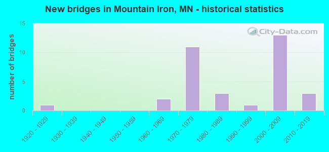
- New bridges - historical statistics
- 11920-1929
- 21960-1969
- 111970-1979
- 31980-1989
- 11990-1999
- 132000-2009
- 32010-2019


- Bridge Condition - Deck
- 13.0%Very good
- 56.5%Good
- 21.7%Satisfactory
- 8.7%Fair

- Bridge Condition - Superstructure
- 26.1%Very good
- 21.7%Good
- 39.1%Satisfactory
- 13.0%Fair

- Bridge Condition - Substructure
- 17.4%Very good
- 52.2%Good
- 8.7%Satisfactory
- 13.0%Fair
- 8.7%Poor

- Bridge Condition - Channel
- 35.3%Very good
- 35.3%Good
- 23.5%Satisfactory
- 5.9%Fair

- Bridge Condition - Culverts
- 20.0%Very good
- 40.0%Good
- 40.0%Satisfactory
Find on map >> Show street view
Structure Number: 9090100000102, Location: 4.6 MI N OF JCT CSAH 68 (Lat: 47.695811, Lng: -92.560539), Route carried "on" structure: Federal lands road 256, Year Built: 1981, Status: Open, Structure Length: 0.76m (2.49ft), Average Daily Traffic: 60 (year 1981), Average Future Daily Traffic: 90 (year 2042), Design Load: HS 20, Features Intersected: RICE RIVER, Facility Carried by Structure: HULM ROAD
Minimum Vertical Clearance: 30+ m (98+ ft), Kilometerpoint: 7.360, Lanes on structure: 2, Owner: U.S. Forest Service, Approaching Roadway Width: 7.3m (24.0ft), Material/Design: Concrete, Design/Construction: Slab, Number Of Spans In Main Unit: 1, Length of Maximum Span: 7.3m (24.0ft), Curb or Sidewalk Widths: Left: 0.2m (0.7ft), Right: 0.2m (0.7ft), Curb-To-Curb Width: 7.3m (24.0ft), Out-to-Out Width: 7.9m (25.9ft)
Condition: Deck: Good, Superstructure: Good, Substructure: Good, Channel: Very good, Operating Rating: 36.0 metric tons, Method Used To Determine Operating Rating: Load and Resistance Factor Rating (LRFR) rating reported by rating factor(RF) method using HL-93 loadings, Inventory Rating: 26.6 metric tons, Method Used To Determine Inventory Rating: Load and Resistance Factor Rating (LRFR) rating reported by rating factor(RF) method using HL-93 loadings, Structural Evaluation: Equal to present minimum criteria, Deck Geometry: Equal to present minimum criteria, Waterway Adequacy: Meets minimum limits, Approach Roadway Alignment: Equal to present desirable criteria, Designated Inspection Frequency: Every 48 months, Inspection Date: September 2020, Deck Structure Type: Concrete Precast Panels, Wearing Surface/Protective System: Wearing Surface: Monolithic Concrete
Find on map >> Show street view
Structure Number: 69014, Location: 3.1 MI N OF JCT TH 169 (Lat: 47.561378, Lng: -92.545617), Route carried "on" structure: , Year Built: 1975, Status: Open, Structure Length: 4.79m (15.72ft), Features Intersected: US 53, Facility Carried by Structure: RAILROAD
Lanes under structure: 4, Owner: Railroad, Material/Design: Steel, Design/Construction: Girder and Floorbeam System, Number Of Spans In Main Unit: 2, Length of Maximum Span: 23.0m (75.5ft), Out-to-Out Width: 5.2m (17.1ft)
Condition: Deck: Satisfactory, Superstructure: Satisfactory, Substructure: Good, Underclear: Equal to present desirable criteria, Bridge Posting: Required (Relationship of Operating Rating to Maximum Legal Load: > 39.9% below), Designated Inspection Frequency: Every 12 months, Inspection Date: August 2021
Find on map >> Show street view
Structure Number: 69034, Location: 0.1 MI W OF S JCT TH 53 (Lat: 47.519097, Lng: -92.562753), Route carried "on" structure: US 169, Year Built: 1970, Status: Open, Structure Length: 4.35m (14.27ft), Average Daily Traffic: 18,729 (year 2019), Truck Traffic: 8%, Average Future Daily Traffic: 18,800 (year 2039), Design Load: HS 20, Features Intersected: DWP RY
Minimum Vertical Clearance: 30+ m (98+ ft), Kilometerpoint: 0.000, Lanes on structure: 5, Base Highway Network: Yes, Owner: State Highway Agency, Approaching Roadway Width: 23.8m (78.1ft), Skew: 20 degrees, Material/Design: Steel continuous, Design/Construction: Stringer/Multi-beam, Number Of Spans In Main Unit: 3, Length of Maximum Span: 17.5m (57.4ft), Curb or Sidewalk Widths: Left: 0.0m, Right: 1.8m (5.9ft), Curb-To-Curb Width: 23.6m (77.4ft), Out-to-Out Width: 28.6m (93.8ft)
Condition: Deck: Good, Superstructure: Very good, Substructure: Satisfactory, Operating Rating: 56.3 metric tons, Method Used To Determine Operating Rating: Load Factor (LF), Inventory Rating: 33.8 metric tons, Method Used To Determine Inventory Rating: Load Factor (LF), Structural Evaluation: Equal to present minimum criteria, Deck Geometry: Better than present minimum criteria, Underclear: Equal to present minimum criteria, Approach Roadway Alignment: Equal to present minimum criteria, Designated Inspection Frequency: Every 24 months, Inspection Date: June 2021, Deck Structure Type: Concrete Cast-file-Place, Wearing Surface/Protective System: Wearing Surface: Low Slump Concrete
Find on map >> Show street view
Structure Number: 69035, Location: AT THE JCT TH 169; 53 (Lat: 47.519189, Lng: -92.561561), Route carried "on" structure: US 169, Year Built: 1969, Year Reconstructed: 2017, Status: Open, Structure Length: 6.23m (20.44ft), Average Daily Traffic: 18,729 (year 2019), Truck Traffic: 8%, Average Future Daily Traffic: 18,800 (year 2039), Design Load: HL 93, Features Intersected: US 53
Minimum Vertical Clearance: 30+ m (98+ ft), Kilometerpoint: 0.000, Lanes on structure: 4, Lanes under structure: 4, Base Highway Network: Yes, Owner: State Highway Agency, Approaching Roadway Width: 23.8m (78.1ft), Material/Design: Prestressed concrete, Design/Construction: Stringer/Multi-beam, Number Of Spans In Main Unit: 4, Length of Maximum Span: 20.1m (65.9ft), Curb or Sidewalk Widths: Left: 2.1m (6.9ft), Right: 2.3m (7.5ft), Curb-To-Curb Width: 21.6m (70.9ft), Out-to-Out Width: 27.0m (88.6ft)
Condition: Deck: Very good, Superstructure: Very good, Substructure: Good, Operating Rating: 59.9 metric tons, Method Used To Determine Operating Rating: Load and Resistance Factor Rating (LRFR) rating reported by rating factor(RF) method using HL-93 loadings, Inventory Rating: 41.5 metric tons, Method Used To Determine Inventory Rating: Load and Resistance Factor Rating (LRFR) rating reported by rating factor(RF) method using HL-93 loadings, Structural Evaluation: Better than present minimum criteria, Deck Geometry: Superior to present desirable criteria, Underclear: Somewhat better than minimum adequacy, Approach Roadway Alignment: Equal to present minimum criteria, Designated Inspection Frequency: Every 24 months, Inspection Date: August 2021, Deck Structure Type: Concrete Cast-file-Place, Wearing Surface/Protective System: Wearing Surface: Monolithic Concrete
Find on map >> Show street view
Structure Number: 69059, Location: 2.6 MI W OF JCT TH 53 (Lat: 47.518586, Lng: -92.615189), Route carried "on" structure: US 169, Year Built: 1970, Status: Open, Structure Length: 7.04m (23.10ft), Average Daily Traffic: 4,700 (year 2015), Truck Traffic: 6%, Average Future Daily Traffic: 4,700 (year 2039), Design Load: HS 20, Features Intersected: CSAH 102
Minimum Vertical Clearance: 30+ m (98+ ft), Kilometerpoint: 0.000, Lanes on structure: 2, Lanes under structure: 4, Base Highway Network: Yes, Owner: State Highway Agency, Approaching Roadway Width: 11.3m (37.1ft), Material/Design: Prestressed concrete, Design/Construction: Stringer/Multi-beam, Number Of Spans In Main Unit: 3, Length of Maximum Span: 29.1m (95.5ft), Curb or Sidewalk Widths: Left: 0.0m, Right: 1.8m (5.9ft), Curb-To-Curb Width: 12.3m (40.4ft), Out-to-Out Width: 13.5m (44.3ft)
Condition: Deck: Good, Superstructure: Satisfactory, Substructure: Satisfactory, Operating Rating: 55.1 metric tons, Method Used To Determine Operating Rating: Load Factor (LF), Inventory Rating: 33.8 metric tons, Method Used To Determine Inventory Rating: Load Factor (LF), Structural Evaluation: Equal to present minimum criteria, Deck Geometry: Better than present minimum criteria, Underclear: Superior to present desirable criteria, Approach Roadway Alignment: Equal to present desirable criteria, Designated Inspection Frequency: Every 24 months, Inspection Date: October 2021, Deck Structure Type: Concrete Cast-file-Place, Wearing Surface/Protective System: Wearing Surface: Low Slump Concrete
Find on map >> Show street view
Structure Number: 6906, Location: 2.6 MI W OF JCT TH 53 (Lat: 47.518364, Lng: -92.615081), Route carried "on" structure: US 169, Year Built: 1970, Status: Open, Structure Length: 7.04m (23.10ft), Average Daily Traffic: 4,850 (year 2019), Truck Traffic: 6%, Average Future Daily Traffic: 4,700 (year 2039), Design Load: HS 20, Features Intersected: CSAH 102
Minimum Vertical Clearance: 30+ m (98+ ft), Kilometerpoint: 0.000, Lanes on structure: 2, Lanes under structure: 4, Base Highway Network: Yes, Owner: State Highway Agency, Approaching Roadway Width: 11.3m (37.1ft), Material/Design: Prestressed concrete, Design/Construction: Stringer/Multi-beam, Number Of Spans In Main Unit: 3, Length of Maximum Span: 29.1m (95.5ft), Curb-To-Curb Width: 12.3m (40.4ft), Out-to-Out Width: 13.5m (44.3ft)
Condition: Deck: Fair, Superstructure: Fair, Substructure: Fair, Operating Rating: 66.9 metric tons, Method Used To Determine Operating Rating: Load Factor (LF), Inventory Rating: 45.7 metric tons, Method Used To Determine Inventory Rating: Load Factor (LF), Structural Evaluation: Somewhat better than minimum adequacy, Deck Geometry: Better than present minimum criteria, Underclear: Superior to present desirable criteria, Approach Roadway Alignment: Equal to present desirable criteria, Length Of Structure Improvement: 2.35m (7.71ft), Designated Inspection Frequency: Every 24 months, Inspection Date: October 2021, Bridge Improvement Cost: $999,999,000, Roadway Improvement Cost: $71,000,000, Total Project Cost: $999,999,000, Deck Structure Type: Concrete Cast-file-Place, Wearing Surface/Protective System: Wearing Surface: Low Slump Concrete
Find on map >> Show street view
Structure Number: 69067, Location: 2.9 MI W OF S JCT TH 53 (Lat: 47.516617, Lng: -92.621061), Route carried "on" structure: US 169, Year Built: 1970, Status: Open, Structure Length: 4.90m (16.08ft), Average Daily Traffic: 4,600 (year 2019), Truck Traffic: 5%, Average Future Daily Traffic: 4,900 (year 2039), Design Load: HS 20, Features Intersected: DM;IR RY
Minimum Vertical Clearance: 30+ m (98+ ft), Kilometerpoint: 0.000, Lanes on structure: 3, Base Highway Network: Yes, Owner: State Highway Agency, Approaching Roadway Width: 13.1m (43.0ft), Skew: 1 degrees, Material/Design: Prestressed concrete, Design/Construction: Stringer/Multi-beam, Number Of Spans In Main Unit: 3, Length of Maximum Span: 17.8m (58.4ft), Curb-To-Curb Width: 14.1m (46.3ft), Out-to-Out Width: 15.4m (50.5ft)
Condition: Deck: Satisfactory, Superstructure: Satisfactory, Substructure: Good, Operating Rating: 63.5 metric tons, Method Used To Determine Operating Rating: Load Factor (LF), Inventory Rating: 33.1 metric tons, Method Used To Determine Inventory Rating: Load Factor (LF), Structural Evaluation: Equal to present minimum criteria, Deck Geometry: Somewhat better than minimum adequacy, Underclear: Meets minimum limits, Approach Roadway Alignment: Equal to present desirable criteria, Designated Inspection Frequency: Every 24 months, Inspection Date: October 2021, Deck Structure Type: Concrete Cast-file-Place, Wearing Surface/Protective System: Wearing Surface: Low Slump Concrete
Find on map >> Show street view
Structure Number: 69068, Location: 2.9 MI W OF S JCT TH 53 (Lat: 47.516406, Lng: -92.620922), Route carried "on" structure: US 169, Year Built: 1970, Status: Open, Structure Length: 4.88m (16.01ft), Average Daily Traffic: 4,600 (year 2019), Truck Traffic: 5%, Average Future Daily Traffic: 4,900 (year 2039), Design Load: HS 20, Features Intersected: DM;IR RY
Minimum Vertical Clearance: 30+ m (98+ ft), Kilometerpoint: 0.000, Lanes on structure: 2, Base Highway Network: Yes, Owner: State Highway Agency, Approaching Roadway Width: 11.3m (37.1ft), Material/Design: Prestressed concrete, Design/Construction: Stringer/Multi-beam, Number Of Spans In Main Unit: 3, Length of Maximum Span: 17.5m (57.4ft), Curb-To-Curb Width: 12.3m (40.4ft), Out-to-Out Width: 13.5m (44.3ft)
Condition: Deck: Good, Superstructure: Satisfactory, Substructure: Good, Operating Rating: 66.8 metric tons, Method Used To Determine Operating Rating: Load Factor (LF), Inventory Rating: 33.3 metric tons, Method Used To Determine Inventory Rating: Load Factor (LF), Structural Evaluation: Equal to present minimum criteria, Deck Geometry: Better than present minimum criteria, Underclear: Meets minimum limits, Approach Roadway Alignment: Equal to present desirable criteria, Designated Inspection Frequency: Every 24 months, Inspection Date: October 2021, Deck Structure Type: Concrete Cast-file-Place, Wearing Surface/Protective System: Wearing Surface: Low Slump Concrete
Find on map >> Show street view
Structure Number: 69125, Location: 0.3 MI N OF JCT TH 53;169 (Lat: 47.590528, Lng: -92.546219), Route carried "on" structure: US 53, Year Built: 2004, Status: Open, Structure Length: 6.80m (22.31ft), Average Daily Traffic: 2,800 (year 2019), Truck Traffic: 9%, Average Future Daily Traffic: 2,800 (year 2039), Design Load: HL 93, Features Intersected: DWP RR
Minimum Vertical Clearance: 30+ m (98+ ft), Kilometerpoint: 0.000, Lanes on structure: 2, Base Highway Network: Yes, Owner: State Highway Agency, Approaching Roadway Width: 11.6m (38.1ft), Skew: 3 degrees, Material/Design: Prestressed concrete, Design/Construction: Stringer/Multi-beam, Number Of Spans In Main Unit: 3, Length of Maximum Span: 22.2m (72.8ft), Curb-To-Curb Width: 12.8m (42.0ft), Out-to-Out Width: 13.8m (45.3ft)
Condition: Deck: Good, Superstructure: Good, Substructure: Good, Operating Rating: 57.3 metric tons, Method Used To Determine Operating Rating: Load Factor (LF), Inventory Rating: 34.3 metric tons, Method Used To Determine Inventory Rating: Load Factor (LF), Structural Evaluation: Better than present minimum criteria, Deck Geometry: Equal to present desirable criteria, Underclear: Superior to present desirable criteria, Approach Roadway Alignment: Equal to present desirable criteria, Designated Inspection Frequency: Every 24 months, Inspection Date: July 2020, Deck Structure Type: Concrete Cast-file-Place, Wearing Surface/Protective System: Wearing Surface: Low Slump Concrete, Deck Protection: Epoxy Coated Reinforcing
Find on map >> Show street view
Structure Number: 69126, Location: .3 MI N OF N JCT TH 169 (Lat: 47.590817, Lng: -92.546197), Route carried "on" structure: US 53, Year Built: 2004, Status: Open, Structure Length: 6.80m (22.31ft), Average Daily Traffic: 2,800 (year 2019), Truck Traffic: 13%, Average Future Daily Traffic: 2,800 (year 2039), Design Load: HL 93, Features Intersected: DWP RR
Minimum Vertical Clearance: 30+ m (98+ ft), Kilometerpoint: 0.000, Lanes on structure: 2, Base Highway Network: Yes, Owner: State Highway Agency, Approaching Roadway Width: 11.6m (38.1ft), Skew: 2 degrees, Material/Design: Prestressed concrete, Design/Construction: Stringer/Multi-beam, Number Of Spans In Main Unit: 3, Length of Maximum Span: 22.2m (72.8ft), Curb-To-Curb Width: 16.2m (53.1ft), Out-to-Out Width: 17.2m (56.4ft)
Condition: Deck: Good, Superstructure: Good, Substructure: Good, Operating Rating: 57.1 metric tons, Method Used To Determine Operating Rating: Load Factor (LF), Inventory Rating: 33.9 metric tons, Method Used To Determine Inventory Rating: Load Factor (LF), Structural Evaluation: Better than present minimum criteria, Deck Geometry: Superior to present desirable criteria, Underclear: Superior to present desirable criteria, Approach Roadway Alignment: Equal to present desirable criteria, Designated Inspection Frequency: Every 24 months, Inspection Date: July 2020, Deck Structure Type: Concrete Cast-file-Place, Wearing Surface/Protective System: Wearing Surface: Low Slump Concrete, Deck Protection: Epoxy Coated Reinforcing
Find on map >> Show street view
Structure Number: 69127, Location: AT THE N JCT TH 53; 169 (Lat: 47.587497, Lng: -92.543067), Route carried "on" structure: US 53, Year Built: 2004, Status: Open, Structure Length: 4.57m (14.99ft), Average Daily Traffic: 2,800 (year 2017), Truck Traffic: 9%, Average Future Daily Traffic: 2,800 (year 2039), Design Load: HL 93, Features Intersected: TH 169
Minimum Vertical Clearance: 30+ m (98+ ft), Kilometerpoint: 0.000, Lanes on structure: 2, Lanes under structure: 2, Base Highway Network: Yes, Owner: State Highway Agency, Approaching Roadway Width: 11.6m (38.1ft), Material/Design: Prestressed concrete, Design/Construction: Stringer/Multi-beam, Number Of Spans In Main Unit: 1, Length of Maximum Span: 44.0m (144.4ft), Curb-To-Curb Width: 12.8m (42.0ft), Out-to-Out Width: 13.8m (45.3ft)
Condition: Deck: Good, Superstructure: Satisfactory, Substructure: Good, Operating Rating: 78.0 metric tons, Method Used To Determine Operating Rating: Load Factor (LF), Inventory Rating: 44.1 metric tons, Method Used To Determine Inventory Rating: Load Factor (LF), Structural Evaluation: Equal to present minimum criteria, Deck Geometry: Equal to present desirable criteria, Underclear: Better than present minimum criteria, Approach Roadway Alignment: Equal to present desirable criteria, Designated Inspection Frequency: Every 24 months, Inspection Date: July 2020, Deck Structure Type: Concrete Cast-file-Place, Wearing Surface/Protective System: Wearing Surface: Low Slump Concrete, Deck Protection: Epoxy Coated Reinforcing
Find on map >> Show street view
Structure Number: 69128, Location: AT THE N JCT TH 53; 169 (Lat: 47.587575, Lng: -92.542694), Route carried "on" structure: US 53, Year Built: 2004, Status: Open, Structure Length: 4.58m (15.03ft), Average Daily Traffic: 2,800 (year 2019), Truck Traffic: 13%, Average Future Daily Traffic: 2,800 (year 2039), Design Load: HL 93, Features Intersected: TH 169
Minimum Vertical Clearance: 30+ m (98+ ft), Kilometerpoint: 0.000, Lanes on structure: 2, Lanes under structure: 2, Base Highway Network: Yes, Owner: State Highway Agency, Approaching Roadway Width: 11.6m (38.1ft), Material/Design: Prestressed concrete, Design/Construction: Stringer/Multi-beam, Number Of Spans In Main Unit: 1, Length of Maximum Span: 44.0m (144.4ft), Curb-To-Curb Width: 14.0m (45.9ft), Out-to-Out Width: 15.0m (49.2ft)
Condition: Deck: Good, Superstructure: Satisfactory, Substructure: Good, Operating Rating: 82.3 metric tons, Method Used To Determine Operating Rating: Load Factor (LF), Inventory Rating: 47.3 metric tons, Method Used To Determine Inventory Rating: Load Factor (LF), Structural Evaluation: Equal to present minimum criteria, Deck Geometry: Superior to present desirable criteria, Underclear: Equal to present desirable criteria, Approach Roadway Alignment: Equal to present desirable criteria, Designated Inspection Frequency: Every 24 months, Inspection Date: July 2020, Deck Structure Type: Concrete Cast-file-Place, Wearing Surface/Protective System: Wearing Surface: Low Slump Concrete, Deck Protection: Epoxy Coated Reinforcing
Find on map >> Show street view
Structure Number: 69131, Location: 0.9 MI N OF CSAH 65 (Lat: 47.673458, Lng: -92.649467), Route carried "on" structure: US 53, Year Built: 2007, Status: Open, Structure Length: 4.13m (13.55ft), Average Daily Traffic: 2,089 (year 2019), Average Future Daily Traffic: 1,875 (year 2039), Design Load: HL 93, Features Intersected: JOHNSON CREEK
Minimum Vertical Clearance: 30+ m (98+ ft), Kilometerpoint: 0.000, Lanes on structure: 2, Base Highway Network: Yes, Owner: State Highway Agency, Approaching Roadway Width: 14.0m (45.9ft), Skew: 4 degrees, Material/Design: Prestressed concrete, Design/Construction: Stringer/Multi-beam, Number Of Spans In Main Unit: 1, Length of Maximum Span: 37.6m (123.4ft), Curb-To-Curb Width: 16.5m (54.1ft), Out-to-Out Width: 17.2m (56.4ft)
Condition: Deck: Good, Superstructure: Good, Substructure: Good, Channel: Satisfactory, Operating Rating: 87.2 metric tons, Method Used To Determine Operating Rating: Load Factor (LF), Inventory Rating: 43.7 metric tons, Method Used To Determine Inventory Rating: Load Factor (LF), Structural Evaluation: Better than present minimum criteria, Deck Geometry: Superior to present desirable criteria, Waterway Adequacy: Equal to present desirable criteria, Approach Roadway Alignment: Equal to present desirable criteria, Designated Inspection Frequency: Every 24 months, Inspection Date: July 2020, Deck Structure Type: Concrete Cast-file-Place, Wearing Surface/Protective System: Wearing Surface: Low Slump Concrete, Deck Protection: Epoxy Coated Reinforcing
Find on map >> Show street view
Structure Number: 69132, Location: 0.9 MI N OF CSAH 65 (Lat: 47.673922, Lng: -92.649392), Route carried "on" structure: US 53, Year Built: 2007, Status: Open, Structure Length: 4.11m (13.48ft), Average Daily Traffic: 2,089 (year 2019), Truck Traffic: 14%, Average Future Daily Traffic: 1,875 (year 2039), Design Load: HL 93, Features Intersected: JOHNSON CREEK
Minimum Vertical Clearance: 30+ m (98+ ft), Kilometerpoint: 0.000, Lanes on structure: 2, Base Highway Network: Yes, Owner: State Highway Agency, Approaching Roadway Width: 11.6m (38.1ft), Skew: 3 degrees, Material/Design: Prestressed concrete, Design/Construction: Stringer/Multi-beam, Number Of Spans In Main Unit: 1, Length of Maximum Span: 37.4m (122.7ft), Curb-To-Curb Width: 14.0m (45.9ft), Out-to-Out Width: 14.0m (45.9ft)
Condition: Deck: Good, Superstructure: Good, Substructure: Good, Channel: Satisfactory, Operating Rating: 88.2 metric tons, Method Used To Determine Operating Rating: Load Factor (LF), Inventory Rating: 42.9 metric tons, Method Used To Determine Inventory Rating: Load Factor (LF), Structural Evaluation: Better than present minimum criteria, Deck Geometry: Superior to present desirable criteria, Waterway Adequacy: Equal to present desirable criteria, Approach Roadway Alignment: Equal to present desirable criteria, Designated Inspection Frequency: Every 24 months, Inspection Date: July 2020, Deck Structure Type: Concrete Cast-file-Place, Wearing Surface/Protective System: Wearing Surface: Low Slump Concrete, Deck Protection: Epoxy Coated Reinforcing
Find on map >> Show street view
Structure Number: 69133, Location: 1.7 MI N OF CSAH 65 (Lat: 47.684219, Lng: -92.653136), Route carried "on" structure: US 53, Year Built: 2007, Status: Open, Structure Length: 2.99m (9.81ft), Average Daily Traffic: 2,089 (year 2019), Average Future Daily Traffic: 1,875 (year 2039), Design Load: HL 93, Features Intersected: JOHNSON CREEK
Minimum Vertical Clearance: 30+ m (98+ ft), Kilometerpoint: 0.000, Lanes on structure: 2, Base Highway Network: Yes, Owner: State Highway Agency, Approaching Roadway Width: 11.6m (38.1ft), Skew: 3 degrees, Material/Design: Prestressed concrete, Design/Construction: Stringer/Multi-beam, Number Of Spans In Main Unit: 1, Length of Maximum Span: 28.0m (91.9ft), Curb-To-Curb Width: 12.8m (42.0ft), Out-to-Out Width: 13.9m (45.6ft)
Condition: Deck: Good, Superstructure: Very good, Substructure: Very good, Channel: Very good, Operating Rating: 68.6 metric tons, Method Used To Determine Operating Rating: Load Factor (LF), Inventory Rating: 37.6 metric tons, Method Used To Determine Inventory Rating: Load Factor (LF), Structural Evaluation: Equal to present desirable criteria, Deck Geometry: Equal to present desirable criteria, Waterway Adequacy: Equal to present desirable criteria, Approach Roadway Alignment: Equal to present desirable criteria, Designated Inspection Frequency: Every 24 months, Inspection Date: July 2020, Deck Structure Type: Concrete Cast-file-Place, Wearing Surface/Protective System: Wearing Surface: Low Slump Concrete, Deck Protection: Epoxy Coated Reinforcing
Find on map >> Show street view
Structure Number: 69134, Location: 1.7 MI N OF CSAH 65 (Lat: 47.684158, Lng: -92.652442), Route carried "on" structure: US 53, Year Built: 2007, Status: Open, Structure Length: 2.99m (9.81ft), Average Daily Traffic: 2,089 (year 2019), Truck Traffic: 14%, Average Future Daily Traffic: 1,875 (year 2039), Design Load: HL 93, Features Intersected: JOHNSON CREEK
Minimum Vertical Clearance: 30+ m (98+ ft), Kilometerpoint: 0.000, Lanes on structure: 2, Base Highway Network: Yes, Owner: State Highway Agency, Approaching Roadway Width: 11.6m (38.1ft), Skew: 3 degrees, Material/Design: Prestressed concrete, Design/Construction: Stringer/Multi-beam, Number Of Spans In Main Unit: 1, Length of Maximum Span: 28.0m (91.9ft), Curb-To-Curb Width: 12.8m (42.0ft), Out-to-Out Width: 13.9m (45.6ft)
Condition: Deck: Good, Superstructure: Very good, Substructure: Very good, Channel: Very good, Operating Rating: 69.7 metric tons, Method Used To Determine Operating Rating: Load Factor (LF), Inventory Rating: 38.5 metric tons, Method Used To Determine Inventory Rating: Load Factor (LF), Structural Evaluation: Equal to present desirable criteria, Deck Geometry: Equal to present desirable criteria, Waterway Adequacy: Equal to present desirable criteria, Approach Roadway Alignment: Equal to present desirable criteria, Designated Inspection Frequency: Every 24 months, Inspection Date: July 2020, Deck Structure Type: Concrete Cast-file-Place, Wearing Surface/Protective System: Wearing Surface: Low Slump Concrete, Deck Protection: Epoxy Coated Reinforcing
Find on map >> Show street view
Structure Number: 69584, Location: 0.3 MI N OF JCT TH 53 (Lat: 47.630781, Lng: -92.550422), Route carried "on" structure: County highway 131, Year Built: 1991, Status: Open, Structure Length: 1.62m (5.31ft), Average Daily Traffic: 270 (year 2015), Average Future Daily Traffic: 270 (year 2039), Design Load: HS 20, Features Intersected: SAND RIVER
Minimum Vertical Clearance: 30+ m (98+ ft), Kilometerpoint: 0.000, Lanes on structure: 2, Owner: County Highway Agency, Approaching Roadway Width: 11.0m (36.1ft), Skew: 2 degrees, Material/Design: Wood or Timber, Design/Construction: Slab, Number Of Spans In Main Unit: 3, Length of Maximum Span: 5.4m (17.7ft), Curb-To-Curb Width: 11.0m (36.1ft), Out-to-Out Width: 11.6m (38.1ft)
Condition: Deck: Satisfactory, Superstructure: Satisfactory, Substructure: Fair, Channel: Good, Operating Rating: 47.3 metric tons, Method Used To Determine Operating Rating: Allowable Stress (AS), Inventory Rating: 34.3 metric tons, Method Used To Determine Inventory Rating: Allowable Stress (AS), Structural Evaluation: Somewhat better than minimum adequacy, Deck Geometry: Equal to present desirable criteria, Waterway Adequacy: Better than present minimum criteria, Approach Roadway Alignment: Better than present minimum criteria, Designated Inspection Frequency: Every 24 months, Inspection Date: August 2021, Deck Structure Type: Wood or Timber, Wearing Surface/Protective System: Wearing Surface: Bituminous
Find on map >> Show street view
Structure Number: 69589, Location: 1.0 MI N OF JCT CSAH 101 (Lat: 47.477208, Lng: -92.613403), Route carried "on" structure: County highway 955, Year Built: 1988, Status: Open, Structure Length: 1.40m (4.59ft), Average Daily Traffic: 180 (year 2011), Average Future Daily Traffic: 180 (year 2039), Design Load: HS 20, Features Intersected: EAST TWO RIVER
Minimum Vertical Clearance: 30+ m (98+ ft), Kilometerpoint: 0.000, Lanes on structure: 2, Owner: County Highway Agency, Approaching Roadway Width: 11.0m (36.1ft), Material/Design: Wood or Timber, Design/Construction: Slab, Number Of Spans In Main Unit: 3, Length of Maximum Span: 5.5m (18.0ft), Curb-To-Curb Width: 9.8m (32.2ft), Out-to-Out Width: 10.4m (34.1ft)
Condition: Deck: Satisfactory, Superstructure: Satisfactory, Substructure: Fair, Channel: Good, Operating Rating: 64.7 metric tons, Method Used To Determine Operating Rating: Allowable Stress (AS), Inventory Rating: 47.3 metric tons, Method Used To Determine Inventory Rating: Allowable Stress (AS), Structural Evaluation: Somewhat better than minimum adequacy, Deck Geometry: Better than present minimum criteria, Waterway Adequacy: Equal to present desirable criteria, Approach Roadway Alignment: Equal to present desirable criteria, Designated Inspection Frequency: Every 24 months, Inspection Date: October 2021, Deck Structure Type: Wood or Timber, Wearing Surface/Protective System: Wearing Surface: Bituminous
Find on map >> Show street view
Structure Number: 69647, Location: 0.2 MI E OF JCT CR 447 (Lat: 47.415419, Lng: -92.705108), Route carried "on" structure: County highway 452, Year Built: 2003, Status: Open, Structure Length: 2.53m (8.30ft), Average Daily Traffic: 310 (year 2011), Average Future Daily Traffic: 310 (year 2039), Design Load: HS 25 or greater, Features Intersected: WEST TWO RIVER
Minimum Vertical Clearance: 30+ m (98+ ft), Kilometerpoint: 0.000, Lanes on structure: 2, Owner: County Highway Agency, Approaching Roadway Width: 11.0m (36.1ft), Material/Design: Steel, Design/Construction: Stringer/Multi-beam, Number Of Spans In Main Unit: 2, Length of Maximum Span: 12.2m (40.0ft), Curb-To-Curb Width: 11.0m (36.1ft), Out-to-Out Width: 11.6m (38.1ft)
Condition: Deck: Good, Superstructure: Satisfactory, Substructure: Good, Channel: Good, Operating Rating: 47.7 metric tons, Method Used To Determine Operating Rating: Load Factor (LF), Inventory Rating: 35.6 metric tons, Method Used To Determine Inventory Rating: Load Factor (LF), Structural Evaluation: Equal to present minimum criteria, Deck Geometry: Equal to present desirable criteria, Waterway Adequacy: Equal to present desirable criteria, Approach Roadway Alignment: Equal to present desirable criteria, Designated Inspection Frequency: Every 24 months, Inspection Date: October 2021, Deck Structure Type: Wood or Timber, Wearing Surface/Protective System: Wearing Surface: Bituminous
Find on map >> Show street view
Structure Number: 69683, Location: 0.5 MI N OF JCT CR 452 (Lat: 47.423131, Lng: -92.707664), Route carried "on" structure: County highway 447, Year Built: 2011, Status: Open, Structure Length: 2.73m (8.96ft), Average Daily Traffic: 255 (year 2011), Average Future Daily Traffic: 255 (year 2031), Design Load: HL 93, Features Intersected: WEST TWO RIVER
Minimum Vertical Clearance: 30+ m (98+ ft), Kilometerpoint: 0.000, Lanes on structure: 2, Owner: County Highway Agency, Approaching Roadway Width: 9.8m (32.2ft), Material/Design: Prestressed concrete, Design/Construction: Stringer/Multi-beam, Number Of Spans In Main Unit: 1, Length of Maximum Span: 26.8m (87.9ft), Curb-To-Curb Width: 9.8m (32.2ft), Out-to-Out Width: 10.8m (35.4ft)
Condition: Deck: Very good, Superstructure: Very good, Substructure: Very good, Channel: Good, Operating Rating: 65.4 metric tons, Method Used To Determine Operating Rating: Load and Resistance Factor Rating (LRFR) rating reported by rating factor(RF) method using HL-93 loadings, Inventory Rating: 41.1 metric tons, Method Used To Determine Inventory Rating: Load and Resistance Factor Rating (LRFR) rating reported by rating factor(RF) method using HL-93 loadings, Structural Evaluation: Equal to present desirable criteria, Deck Geometry: Better than present minimum criteria, Waterway Adequacy: Equal to present desirable criteria, Approach Roadway Alignment: Better than present minimum criteria, Designated Inspection Frequency: Every 24 months, Inspection Date: September 2021, Deck Structure Type: Concrete Cast-file-Place, Wearing Surface/Protective System: Wearing Surface: Monolithic Concrete, Deck Protection: Epoxy Coated Reinforcing
Find on map >> Show street view
Structure Number: 69A32, Location: 1.4 MI S OF JCT CR461 (Lat: 47.623547, Lng: -92.731767), Route carried "on" structure: County highway 668, Year Built: 2016, Status: Open, Structure Length: 1.28m (4.20ft), Average Daily Traffic: 22 (year 2015), Average Future Daily Traffic: 27 (year 2035), Design Load: HL 93, Features Intersected: DARK RIVER
Minimum Vertical Clearance: 30+ m (98+ ft), Kilometerpoint: 0.000, Lanes on structure: 2, Owner: County Highway Agency, Approaching Roadway Width: 8.5m (27.9ft), Material/Design: Prestressed concrete, Design/Construction: Stringer/Multi-beam, Number Of Spans In Main Unit: 1, Length of Maximum Span: 12.2m (40.0ft), Curb-To-Curb Width: 8.5m (27.9ft), Out-to-Out Width: 9.5m (31.2ft)
Condition: Deck: Very good, Superstructure: Very good, Substructure: Very good, Channel: Very good, Operating Rating: 80.4 metric tons, Method Used To Determine Operating Rating: Load and Resistance Factor Rating (LRFR) rating reported by rating factor(RF) method using HL-93 loadings, Inventory Rating: 41.5 metric tons, Method Used To Determine Inventory Rating: Load and Resistance Factor Rating (LRFR) rating reported by rating factor(RF) method using HL-93 loadings, Structural Evaluation: Equal to present desirable criteria, Deck Geometry: Better than present minimum criteria, Waterway Adequacy: Superior to present desirable criteria, Approach Roadway Alignment: Better than present minimum criteria, Designated Inspection Frequency: Every 24 months, Inspection Date: June 2021, Deck Structure Type: Concrete Cast-file-Place, Wearing Surface/Protective System: Wearing Surface: Monolithic Concrete, Deck Protection: Epoxy Coated Reinforcing
Find on map >> Show street view
Structure Number: 69J42, Location: 0.8 MI E OF JCT CSAH 62 (Lat: 47.444325, Lng: -92.638292), Route carried "on" structure: County highway 317, Year Built: 2003, Status: Open, Structure Length: 0.74m (2.43ft), Average Daily Traffic: 5 (year 2011), Average Future Daily Traffic: 5 (year 2039), Design Load: HS 25 or greater, Features Intersected: EAST TWO RIVER
Minimum Vertical Clearance: 30+ m (98+ ft), Kilometerpoint: 0.000, Lanes on structure: 2, Owner: County Highway Agency, Approaching Roadway Width: 8.5m (27.9ft), Skew: 4 degrees, Material/Design: Aluminum, Iron, Design/Construction: Culvert, Number Of Spans In Main Unit: 1, Length of Maximum Span: 7.4m (24.3ft)
Condition: Channel: Good, Culverts: Good, Operating Rating: 42.1 metric tons, Method Used To Determine Operating Rating: Load and Resistance Factor Rating (LRFR) rating reported by rating factor(RF) method using HL-93 loadings, Inventory Rating: 32.4 metric tons, Method Used To Determine Inventory Rating: Load and Resistance Factor Rating (LRFR) rating reported by rating factor(RF) method using HL-93 loadings, Structural Evaluation: Better than present minimum criteria, Waterway Adequacy: Superior to present desirable criteria, Approach Roadway Alignment: Better than present minimum criteria, Designated Inspection Frequency: Every 48 months, Inspection Date: July 2021
Find on map >> Show street view
Structure Number: 69K58, Location: 2.6 MI S OF JCT TH 169 (Lat: 47.461247, Lng: -92.687614), Route carried "on" structure: County highway 137, Year Built: 2018, Status: Open, Structure Length: 1.67m (5.48ft), Average Daily Traffic: 400 (year 2018), Average Future Daily Traffic: 480 (year 2038), Design Load: HL 93, Features Intersected: WEST TWO RIVERS
Minimum Vertical Clearance: 30+ m (98+ ft), Kilometerpoint: 0.000, Lanes on structure: 2, Owner: County Highway Agency, Approaching Roadway Width: 9.8m (32.2ft), Skew: 5 degrees, Material/Design: Concrete, Design/Construction: Culvert, Number Of Spans In Main Unit: 2, Length of Maximum Span: 7.6m (24.9ft)
Condition: Channel: Very good, Culverts: Very good, Operating Rating: 46.3 metric tons, Method Used To Determine Operating Rating: Load and Resistance Factor Rating (LRFR) rating reported by rating factor(RF) method using HL-93 loadings, Inventory Rating: 35.6 metric tons, Method Used To Determine Inventory Rating: Load and Resistance Factor Rating (LRFR) rating reported by rating factor(RF) method using HL-93 loadings, Structural Evaluation: Equal to present desirable criteria, Waterway Adequacy: Superior to present desirable criteria, Approach Roadway Alignment: Equal to present desirable criteria, Designated Inspection Frequency: Every 48 months, Inspection Date: July 2021
Find on map >> Show street view
Structure Number: 69X05, Location: 3.31 MI N OF N JCT US 169 (Lat: 47.630939, Lng: -92.554908), Route carried "on" structure: US 53, Year Built: 2007, Status: Open, Structure Length: 0.80m (2.62ft), Average Daily Traffic: 4,100 (year 2019), Truck Traffic: 14%, Average Future Daily Traffic: 3,850 (year 2039), Design Load: HS 25 or greater, Features Intersected: SANDY RIVER
Minimum Vertical Clearance: 30+ m (98+ ft), Kilometerpoint: 0.000, Lanes on structure: 2, Base Highway Network: Yes, Owner: State Highway Agency, Approaching Roadway Width: 23.2m (76.1ft), Skew: 2 degrees, Material/Design: Concrete, Design/Construction: Culvert, Number Of Spans In Main Unit: 2, Length of Maximum Span: 3.3m (10.8ft)
Condition: Channel: Very good, Culverts: Good, Operating Rating: 68.6 metric tons, Method Used To Determine Operating Rating: Assigned rating based on Load Factor Design (LFD) reported in metric tons, Inventory Rating: 40.8 metric tons, Method Used To Determine Inventory Rating: Assigned rating based on Load Factor Design (LFD) reported in metric tons, Structural Evaluation: Better than present minimum criteria, Waterway Adequacy: Equal to present desirable criteria, Approach Roadway Alignment: Equal to present desirable criteria, Designated Inspection Frequency: Every 48 months, Inspection Date: July 2018
Find on map >> Show street view
Structure Number: 7759, Location: 0.3 MI E OF JCT CR315 (Lat: 47.462781, Lng: -92.617308), Route carried "on" structure: County highway 101, Year Built: 1928, Status: Posted for load, Structure Length: 1.16m (3.81ft), Average Daily Traffic: 215 (year 2015), Average Future Daily Traffic: 215 (year 2039), Features Intersected: EAST TWO RIVER
Minimum Vertical Clearance: 30+ m (98+ ft), Kilometerpoint: 0.000, Lanes on structure: 2, Owner: County Highway Agency, Approaching Roadway Width: 8.5m (27.9ft), Material/Design: Steel, Design/Construction: Stringer/Multi-beam, Number Of Spans In Main Unit: 1, Length of Maximum Span: 10.7m (35.1ft), Curb-To-Curb Width: 7.0m (23.0ft), Out-to-Out Width: 7.9m (25.9ft)
Condition: Deck: Satisfactory, Superstructure: Fair, Substructure: Poor, Channel: Fair, Operating Rating: 27.1 metric tons, Method Used To Determine Operating Rating: Load Factor (LF), Inventory Rating: 16.3 metric tons, Method Used To Determine Inventory Rating: Load Factor (LF), Structural Evaluation: Meets minimum limits, Deck Geometry: Meets minimum limits, Waterway Adequacy: Equal to present desirable criteria, Approach Roadway Alignment: Equal to present desirable criteria, Bridge Posting: Required (Relationship of Operating Rating to Maximum Legal Load: > 39.9% below), Designated Inspection Frequency: Every 12 months, Underwater Inspection Frequency: Every 60 months, Inspection Date: August 2021, Underwater Inspection Date: September 2021, Bridge Improvement Cost: $850,000,000, Roadway Improvement Cost: $150,000,000, Total Project Cost: $999,999,000 ( Estimate for 2017), Deck Structure Type: Concrete Cast-file-Place, Wearing Surface/Protective System: Wearing Surface: Bituminous
Find on map >> Show street view
Structure Number: 7865, Location: 0.3 MI N OF JCT CR317 (Lat: 47.448936, Lng: -92.622994), Route carried "on" structure: County highway 315, Year Built: 1972, Status: Open, Structure Length: 0.98m (3.22ft), Average Daily Traffic: 130 (year 2011), Average Future Daily Traffic: 130 (year 2039), Features Intersected: EAST TWO RIVERS
Minimum Vertical Clearance: 30+ m (98+ ft), Kilometerpoint: 0.000, Lanes on structure: 2, Owner: County Highway Agency, Approaching Roadway Width: 7.0m (23.0ft), Material/Design: Steel, Design/Construction: Stringer/Multi-beam, Number Of Spans In Main Unit: 1, Length of Maximum Span: 8.7m (28.5ft), Curb-To-Curb Width: 7.4m (24.3ft), Out-to-Out Width: 7.7m (25.3ft)
Condition: Deck: Fair, Superstructure: Fair, Substructure: Poor, Channel: Satisfactory, Operating Rating: 50.6 metric tons, Method Used To Determine Operating Rating: Load Factor (LF), Inventory Rating: 30.4 metric tons, Method Used To Determine Inventory Rating: Load Factor (LF), Structural Evaluation: Meets minimum limits, Deck Geometry: Somewhat better than minimum adequacy, Waterway Adequacy: Equal to present desirable criteria, Approach Roadway Alignment: Better than present minimum criteria, Designated Inspection Frequency: Every 12 months, Underwater Inspection Frequency: Every 60 months, Inspection Date: May 2021, Underwater Inspection Date: September 2016, Bridge Improvement Cost: $600,000,000, Roadway Improvement Cost: $150,000,000, Total Project Cost: $750,000,000 ( Estimate for 2017), Deck Structure Type: Wood or Timber, Wearing Surface/Protective System: Wearing Surface: Bituminous
Find on map >> Show street view
Structure Number: 9138, Location: 10.7 MI E OF JCT TH 169 (Lat: 47.401000, Lng: -92.702483), Route carried "on" structure: State highway 37, Year Built: 1976, Status: Open, Structure Length: 0.99m (3.25ft), Average Daily Traffic: 4,300 (year 2019), Truck Traffic: 10%, Average Future Daily Traffic: 4,600 (year 2039), Design Load: HS 20, Features Intersected: WEST TWO RIVERS
Minimum Vertical Clearance: 30+ m (98+ ft), Kilometerpoint: 0.000, Lanes on structure: 2, Base Highway Network: Yes, Owner: State Highway Agency, Approaching Roadway Width: 14.3m (46.9ft), Skew: 1 degrees, Material/Design: Concrete, Design/Construction: Culvert, Number Of Spans In Main Unit: 2, Length of Maximum Span: 4.4m (14.4ft)
Condition: Channel: Good, Culverts: Satisfactory, Operating Rating: 39.2 metric tons, Method Used To Determine Operating Rating: Assigned ratings based on Allowable Stress Design (ASD) reported in metric tons, Inventory Rating: 29.4 metric tons, Method Used To Determine Inventory Rating: Assigned ratings based on Allowable Stress Design (ASD) reported in metric tons, Structural Evaluation: Equal to present minimum criteria, Waterway Adequacy: Equal to present desirable criteria, Approach Roadway Alignment: Equal to present desirable criteria, Designated Inspection Frequency: Every 24 months, Inspection Date: May 2020
Find on map >> Show street view
Structure Number: 93504, Location: 0.2 MI W OF JCT CSAH 7 (Lat: 47.485803, Lng: -92.599678), Route carried "on" structure: County highway 102, Year Built: 1980, Status: Open, Structure Length: 1.25m (4.10ft), Average Daily Traffic: 540 (year 2015), Average Future Daily Traffic: 540 (year 2039), Design Load: HS 20, Features Intersected: EAST TWO RIVER
Minimum Vertical Clearance: 30+ m (98+ ft), Kilometerpoint: 0.000, Lanes on structure: 2, Owner: County Highway Agency, Approaching Roadway Width: 13.4m (44.0ft), Material/Design: Concrete, Design/Construction: Culvert, Number Of Spans In Main Unit: 3, Length of Maximum Span: 2.9m (9.5ft)
Condition: Channel: Satisfactory, Culverts: Satisfactory, Operating Rating: 53.9 metric tons, Method Used To Determine Operating Rating: Assigned ratings based on Allowable Stress Design (ASD) reported in metric tons, Inventory Rating: 35.9 metric tons, Method Used To Determine Inventory Rating: Assigned ratings based on Allowable Stress Design (ASD) reported in metric tons, Structural Evaluation: Equal to present minimum criteria, Waterway Adequacy: Superior to present desirable criteria, Approach Roadway Alignment: Equal to present desirable criteria, Designated Inspection Frequency: Every 48 months, Inspection Date: June 2021
Find on map >> Show street view
Structure Number: 69014, Location: 3.1 MI N OF JCT TH 169 (Lat: 47.561378, Lng: -92.545617), Route carried "under" structure: US 53, Year Built: 1975, Structure Length: 0. m, Average Daily Traffic: 12,154 (year 2019), Truck Traffic: 5%, Features Intersected: US 53, Facility Carried by Structure: RAILROAD
Minimum Vertical Clearance: 5.21m (17.09ft), Kilometerpoint: 0.000, Lanes on structure: 4, Lanes under structure: 4, Material/Design: Steel, Design/Construction: Girder and Floorbeam System, Length of Maximum Span: 23.0m (75.5ft)
Find on map >> Show street view
Structure Number: 69035, Location: AT THE JCT TH 169; 53 (Lat: 47.519189, Lng: -92.561561), Route carried "under" structure: US 53, Year Built: 1969, Structure Length: 0. m, Average Daily Traffic: 12,300 (year 2019), Truck Traffic: 5%, Features Intersected: US 53, Facility Carried by Structure: US 169
Minimum Vertical Clearance: 6.01m (19.72ft), Kilometerpoint: 0.000, Lanes on structure: 4, Lanes under structure: 4, Material/Design: Prestressed concrete, Design/Construction: Stringer/Multi-beam, Length of Maximum Span: 20.1m (65.9ft)
Find on map >> Show street view
Structure Number: 69059, Location: 2.6 MI W OF JCT TH 53 (Lat: 47.518586, Lng: -92.615189), Route carried "under" structure: County highway 102, Year Built: 1970, Structure Length: 0. m, Average Daily Traffic: 2,450 (year 2003), Features Intersected: CSAH 102, Facility Carried by Structure: US 169
Minimum Vertical Clearance: 5.33m (17.49ft), Kilometerpoint: 0.000, Lanes on structure: 2, Lanes under structure: 4, Material/Design: Prestressed concrete, Design/Construction: Stringer/Multi-beam, Length of Maximum Span: 29.1m (95.5ft)
Find on map >> Show street view
Structure Number: 6906, Location: 2.6 MI W OF JCT TH 53 (Lat: 47.518364, Lng: -92.615081), Route carried "under" structure: County highway 102, Year Built: 1970, Structure Length: 0. m, Average Daily Traffic: 2,450 (year 2003), Features Intersected: CSAH 102, Facility Carried by Structure: US 169
Minimum Vertical Clearance: 5.33m (17.49ft), Kilometerpoint: 0.000, Lanes on structure: 2, Lanes under structure: 4, Material/Design: Prestressed concrete, Design/Construction: Stringer/Multi-beam, Length of Maximum Span: 29.1m (95.5ft)
Find on map >> Show street view
Structure Number: 69127, Location: AT THE N JCT TH 53; 169 (Lat: 47.587497, Lng: -92.543067), Route carried "under" structure: Ramp US 1704, Year Built: 2004, Structure Length: 0. m, Average Daily Traffic: 5,900 (year 2004), Truck Traffic: 5%, Features Intersected: TH 169, Facility Carried by Structure: US 53
Minimum Vertical Clearance: 5.00m (16.40ft), Kilometerpoint: 0.000, Lanes on structure: 2, Lanes under structure: 2, Material/Design: Prestressed concrete, Design/Construction: Stringer/Multi-beam, Length of Maximum Span: 44.0m (144.4ft)
Find on map >> Show street view
Structure Number: 69128, Location: AT THE N JCT TH 53; 169 (Lat: 47.587575, Lng: -92.542694), Route carried "under" structure: State highway 169, Year Built: 2004, Structure Length: 0. m, Average Daily Traffic: 6,500 (year 2019), Truck Traffic: 7%, Features Intersected: TH 169, Facility Carried by Structure: US 53
Minimum Vertical Clearance: 5.15m (16.90ft), Kilometerpoint: 0.000, Lanes on structure: 2, Lanes under structure: 2, Material/Design: Prestressed concrete, Design/Construction: Stringer/Multi-beam, Length of Maximum Span: 44.0m (144.4ft)