Bridge Statistics for Neptune City, New Jersey (NJ)
Condition, Traffic, Stress, Structural Evaluation, Project Costs
- National Bridge Inventory (NBI) Statistics
- 10Number of bridges
- 240ft / 73.3mTotal length
- $1,240,000Total costs
- 130,737Total average daily traffic
- 5,187Total average daily truck traffic
- National Bridge Inventory (NBI) Registered Bridges for Neptune City
- No street view available for this location
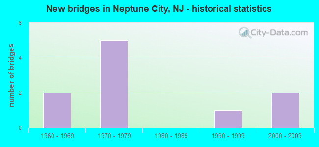
- New bridges - historical statistics
- 21960-1969
- 51970-1979
- 11990-1999
- 22000-2009


- Bridge Condition - Deck
- 66.7%Good
- 33.3%Satisfactory

- Bridge Condition - Superstructure
- 33.3%Very good
- 16.7%Good
- 50.0%Satisfactory

- Bridge Condition - Substructure
- 66.7%Good
- 33.3%Satisfactory

- Bridge Condition - Channel
- 66.7%Very good
- 33.3%Good
Find on map >> Show street view
Structure Number: 1300N14, Location: 0.04 mile S of Sunset Ave (Lat: 40.225869, Lng: -74.004839), Route carried "on" structure: City street , Year Built: 2003, Status: Open, Structure Length: 3.87m (12.70ft), Average Daily Traffic: 10,365 (year 2021), Truck Traffic: 1%, Average Future Daily Traffic: 12,648 (year 2041), Design Load: HS 20+Mod, Features Intersected: SUNSET LAKE, Facility Carried by Structure: GRAND AVENUE
Minimum Vertical Clearance: 30+ m (98+ ft), Kilometerpoint: 0.000, Lanes on structure: 2, Owner: County Highway Agency, Approaching Roadway Width: 12.8m (42.0ft), Material/Design: Prestressed concrete, Design/Construction: Stringer/Multi-beam, Number Of Spans In Main Unit: 3, Length of Maximum Span: 11.9m (39.0ft), Curb or Sidewalk Widths: Left: 1.5m (4.9ft), Right: 1.5m (4.9ft), Curb-To-Curb Width: 12.2m (40.0ft), Out-to-Out Width: 16.6m (54.5ft)
Condition: Deck: Good, Superstructure: Very good, Substructure: Good, Channel: Very good, Operating Rating: 79.8 metric tons, Method Used To Determine Operating Rating: Load Factor (LF), Inventory Rating: 48.1 metric tons, Method Used To Determine Inventory Rating: Load Factor (LF), Structural Evaluation: Better than present minimum criteria, Deck Geometry: Somewhat better than minimum adequacy, Waterway Adequacy: Equal to present desirable criteria, Approach Roadway Alignment: Better than present minimum criteria, Designated Inspection Frequency: Every 24 months, Underwater Inspection Frequency: Every 48 months, Inspection Date: May 2021, Underwater Inspection Date: July 2021, Deck Structure Type: Concrete Cast-file-Place, Wearing Surface/Protective System: Wearing Surface: Monolithic Concrete, Deck Protection: Galvanized Reinforcing
Find on map >> Show street view
Structure Number: 1300N17, Location: 1/2 MILE EAST OF NJ 18 (Lat: 40.196911, Lng: -74.041950), Route carried "on" structure: County highway , Year Built: 1990, Year Reconstructed: 2018, Status: Open, Structure Length: 1.89m (6.20ft), Average Daily Traffic: 5,201 (year 2021), Truck Traffic: 3%, Average Future Daily Traffic: 6,346 (year 2041), Design Load: HS 20+Mod, Features Intersected: MUSQUASH BROOK, Facility Carried by Structure: EAST END AVENUE
Minimum Vertical Clearance: 30+ m (98+ ft), Kilometerpoint: 0.612, Lanes on structure: 2, Owner: County Highway Agency, Approaching Roadway Width: 9.1m (29.9ft), Material/Design: Concrete continuous, Design/Construction: Slab, Number Of Spans In Main Unit: 4, Length of Maximum Span: 4.6m (15.1ft), Curb or Sidewalk Widths: Left: 0.0m, Right: 1.7m (5.6ft), Curb-To-Curb Width: 9.1m (29.9ft), Out-to-Out Width: 11.9m (39.0ft)
Condition: Deck: Satisfactory, Superstructure: Satisfactory, Substructure: Satisfactory, Channel: Very good, Operating Rating: 70.8 metric tons, Method Used To Determine Operating Rating: Load Factor (LF), Inventory Rating: 41.7 metric tons, Method Used To Determine Inventory Rating: Load Factor (LF), Structural Evaluation: Equal to present minimum criteria, Deck Geometry: High priority of corrective action, Waterway Adequacy: Equal to present desirable criteria, Approach Roadway Alignment: Equal to present desirable criteria, Designated Inspection Frequency: Every 24 months, Underwater Inspection Frequency: Every 48 months, Inspection Date: May 2021, Underwater Inspection Date: November 2021, Deck Structure Type: Concrete Cast-file-Place, Wearing Surface/Protective System: Wearing Surface: Bituminous, Deck Protection: Galvanized Reinforcing
Find on map >> Show street view
Structure Number: 131115, Location: 1.36 MI NORTH OF NJ-138 (Lat: 40.182461, Lng: -74.027119), Route carried "on" structure: State highway 35, Year Built: 2005, Status: Open, Structure Length: 53.92m (176.90ft), Average Daily Traffic: 31,905 (year 2020), Truck Traffic: 4%, Average Future Daily Traffic: 38,285 (year 2040), Design Load: HL 93, Features Intersected: SHARK RIVER
Minimum Vertical Clearance: 30+ m (98+ ft), Kilometerpoint: 34.762, Lanes on structure: 4, Lanes under structure: 3, Base Highway Network: Yes, Owner: State Highway Agency, Approaching Roadway Width: 25.6m (84.0ft), Skew: 30 degrees, Navigation Control: Yes ( Vertical Clearance: 15.2m (49.9ft), Horizontal Clearance: 15.2m (49.9ft)), Material/Design: Prestressed concrete continuous, Design/Construction: Stringer/Multi-beam, Number Of Spans In Main Unit: 3, Number Of Approach Spans: 13, Length of Maximum Span: 51.8m (169.9ft), Curb or Sidewalk Widths: Left: 1.8m (5.9ft), Right: 0.0m, Curb-To-Curb Width: 21.0m (68.9ft), Out-to-Out Width: 25.7m (84.3ft)
Condition: Deck: Good, Superstructure: Good, Substructure: Good, Channel: Good, Operating Rating: 61.7 metric tons, Method Used To Determine Operating Rating: Field evaluation and documented engineering judgment, Inventory Rating: 47.2 metric tons, Method Used To Determine Inventory Rating: Field evaluation and documented engineering judgment, Structural Evaluation: Better than present minimum criteria, Deck Geometry: Superior to present desirable criteria, Underclear: Somewhat better than minimum adequacy, Waterway Adequacy: Superior to present desirable criteria, Approach Roadway Alignment: Equal to present minimum criteria, Designated Inspection Frequency: Every 24 months, Underwater Inspection Frequency: Every 48 months, Inspection Date: August 2020, Underwater Inspection Date: October 2018, Deck Structure Type: Concrete Cast-file-Place, Wearing Surface/Protective System: Deck Protection: Epoxy Coated Reinforcing
Find on map >> Show street view
Structure Number: 1311157, Location: .5 MI NO. OF SHARK RIVER (Lat: 40.192639, Lng: -74.023311), Route carried "on" structure: City street , Year Built: 1972, Status: Open, Structure Length: 3.96m (12.99ft), Average Daily Traffic: 1,700 (year 2020), Truck Traffic: 3%, Average Future Daily Traffic: 2,040 (year 2040), Design Load: HS 20, Features Intersected: NJT,MEMORIAL DR (CR40A), Facility Carried by Structure: SYLVANIA AVE
Minimum Vertical Clearance: 30+ m (98+ ft), Kilometerpoint: 0.000, Lanes on structure: 2, Lanes under structure: 4, Owner: State Highway Agency, Approaching Roadway Width: 14.0m (45.9ft), Skew: 30 degrees, Material/Design: Steel, Design/Construction: Stringer/Multi-beam, Number Of Spans In Main Unit: 2, Length of Maximum Span: 21.6m (70.9ft), Curb or Sidewalk Widths: Left: 1.8m (5.9ft), Right: 0.9m (3.0ft), Curb-To-Curb Width: 14.0m (45.9ft), Out-to-Out Width: 18.0m (59.1ft)
Condition: Deck: Good, Superstructure: Satisfactory, Substructure: Satisfactory, Operating Rating: 86.2 metric tons, Method Used To Determine Operating Rating: Load Factor (LF), Inventory Rating: 51.7 metric tons, Method Used To Determine Inventory Rating: Load Factor (LF), Structural Evaluation: Equal to present minimum criteria, Deck Geometry: Superior to present desirable criteria, Underclear: High priority of corrective action, Approach Roadway Alignment: Equal to present minimum criteria, Length Of Structure Improvement: 3.96m (12.99ft), Designated Inspection Frequency: Every 24 months, Inspection Date: August 2020, Bridge Improvement Cost: $712,000, Roadway Improvement Cost: $142,000, Total Project Cost: $1,097,000 ( Estimate for 2020), Deck Structure Type: Concrete Cast-file-Place, Wearing Surface/Protective System: Wearing Surface: Monolithic Concrete
Find on map >> Show street view
Structure Number: 1311158, Location: .45 MI NO. OF SHARK RIVER (Lat: 40.190761, Lng: -74.024189), Route carried "on" structure: State highway 35, Year Built: 1972, Status: Open, Structure Length: 3.54m (11.61ft), Average Daily Traffic: 16,112 (year 2021), Truck Traffic: 4%, Average Future Daily Traffic: 19,334 (year 2041), Design Load: HS 20+Mod, Features Intersected: CR 40A & Ramp 4
Minimum Vertical Clearance: 30+ m (98+ ft), Kilometerpoint: 35.486, Lanes on structure: 3, Lanes under structure: 2, Base Highway Network: Yes, Owner: State Highway Agency, Approaching Roadway Width: 11.6m (38.1ft), Skew: 2 degrees, Material/Design: Steel, Design/Construction: Stringer/Multi-beam, Number Of Spans In Main Unit: 1, Length of Maximum Span: 34.1m (111.9ft), Curb or Sidewalk Widths: Left: 0.9m (3.0ft), Right: 1.1m (3.6ft), Curb-To-Curb Width: 11.6m (38.1ft), Out-to-Out Width: 14.4m (47.2ft)
Condition: Deck: Good, Superstructure: Very good, Substructure: Good, Operating Rating: 70.8 metric tons, Method Used To Determine Operating Rating: Load Factor (LF), Inventory Rating: 42.6 metric tons, Method Used To Determine Inventory Rating: Load Factor (LF), Structural Evaluation: Better than present minimum criteria, Deck Geometry: High priority of replacement, Underclear: High priority of corrective action, Approach Roadway Alignment: Somewhat better than minimum adequacy, Length Of Structure Improvement: 3.54m (11.61ft), Designated Inspection Frequency: Every 24 months, Inspection Date: August 2021, Bridge Improvement Cost: $77,000, Roadway Improvement Cost: $21,000, Total Project Cost: $143,000 ( Estimate for 2019), Deck Structure Type: Concrete Cast-file-Place, Wearing Surface/Protective System: Wearing Surface: Monolithic Concrete
Find on map >> Show street view
Structure Number: 1328153, Location: 0.9 MILES NORTH OF JCT 33 (Lat: 40.219489, Lng: -74.051619), Route carried "on" structure: County highway , Year Built: 1968, Status: Open, Structure Length: 6.16m (20.21ft), Average Daily Traffic: 10,799 (year 2019), Truck Traffic: 3%, Average Future Daily Traffic: 13,177 (year 2039), Design Load: HS 20, Features Intersected: RT 18, Facility Carried by Structure: WEST BANGS AVENUE
Minimum Vertical Clearance: 30+ m (98+ ft), Kilometerpoint: 3.299, Lanes on structure: 2, Lanes under structure: 4, Owner: State Highway Agency, Approaching Roadway Width: 12.2m (40.0ft), Material/Design: Prestressed concrete, Design/Construction: Stringer/Multi-beam, Number Of Spans In Main Unit: 2, Length of Maximum Span: 29.6m (97.1ft), Curb or Sidewalk Widths: Left: 0.5m (1.6ft), Right: 1.8m (5.9ft), Curb-To-Curb Width: 9.1m (29.9ft), Out-to-Out Width: 12.2m (40.0ft)
Condition: Deck: Satisfactory, Superstructure: Satisfactory, Substructure: Good, Operating Rating: 70.8 metric tons, Method Used To Determine Operating Rating: Load Factor (LF), Inventory Rating: 20.9 metric tons, Method Used To Determine Inventory Rating: Load Factor (LF), Structural Evaluation: Somewhat better than minimum adequacy, Deck Geometry: Meets minimum limits, Underclear: Equal to present minimum criteria, Approach Roadway Alignment: Equal to present desirable criteria, Designated Inspection Frequency: Every 24 months, Inspection Date: May 2021, Deck Structure Type: Concrete Cast-file-Place, Wearing Surface/Protective System: Wearing Surface: Monolithic Concrete
Find on map >> Show street view
Structure Number: 1311157, Location: .5 MI NO. OF SHARK RIVER (Lat: 40.192639, Lng: -74.023311), Route carried "under" structure: County highway 40, Year Built: 1972, Structure Length: 0. m, Average Daily Traffic: 1,377 (year 2020), Truck Traffic: 1%, Features Intersected: NJT,MEMORIAL DR (CR40A), Facility Carried by Structure: SYLVANIA AVE
Minimum Vertical Clearance: 5.49m (18.01ft), Kilometerpoint: 2.897, Lanes on structure: 2, Lanes under structure: 4, Material/Design: Steel, Design/Construction: Stringer/Multi-beam, Length of Maximum Span: 21.6m (70.9ft)
Find on map >> Show street view
Structure Number: 1311158, Location: .45 MI NO. OF SHARK RIVER (Lat: 40.190761, Lng: -74.024189), Route carried "under" structure: Ramp State highway 35, Year Built: 1972, Structure Length: 0. m, Average Daily Traffic: 1,420 (year 2021), Truck Traffic: 4%, Features Intersected: CR 40A & Ramp 4
Minimum Vertical Clearance: 4.48m (14.70ft), Kilometerpoint: 35.486, Lanes on structure: 3, Lanes under structure: 1, Material/Design: Steel, Design/Construction: Stringer/Multi-beam, Length of Maximum Span: 34.1m (111.9ft)
Find on map >> Show street view
Structure Number: 1311158, Location: .45 MI NO. OF SHARK RIVER (Lat: 40.190761, Lng: -74.024189), Route carried "under" structure: County highway 40A, Year Built: 1972, Structure Length: 0. m, Average Daily Traffic: 1,339 (year 2021), Truck Traffic: 3%, Features Intersected: CR 40A & Ramp 4, Facility Carried by Structure: NJ 35 NB
Minimum Vertical Clearance: 4.45m (14.60ft), Kilometerpoint: 3.058, Lanes on structure: 3, Lanes under structure: 1, Material/Design: Steel, Design/Construction: Stringer/Multi-beam, Length of Maximum Span: 34.1m (111.9ft)
Find on map >> Show street view
Structure Number: 1328153, Location: 0.9 MILES NORTH OF JCT 33 (Lat: 40.219489, Lng: -74.051619), Route carried "under" structure: State highway 18, Year Built: 1968, Structure Length: 0. m, Average Daily Traffic: 50,519 (year 2019), Truck Traffic: 5%, Features Intersected: RT 18, Facility Carried by Structure: WEST BANGS AVENUE
Minimum Vertical Clearance: 7.03m (23.06ft), Kilometerpoint: 14.838, Lanes on structure: 2, Lanes under structure: 4, Material/Design: Prestressed concrete, Design/Construction: Stringer/Multi-beam, Length of Maximum Span: 29.6m (97.1ft)