Bridge Statistics for New Carrollton, Maryland (MD)
Condition, Traffic, Stress, Structural Evaluation, Project Costs
- National Bridge Inventory (NBI) Statistics
- 11Number of bridges
- 112ft / 34.0mTotal length
- $5,087,000Total costs
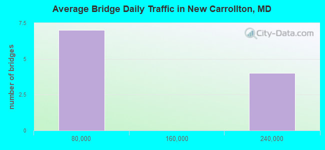
- 970,109Total average daily traffic
- 74,155Total average daily truck traffic
- National Bridge Inventory (NBI) Registered Bridges for New Carrollton
- No street view available for this location
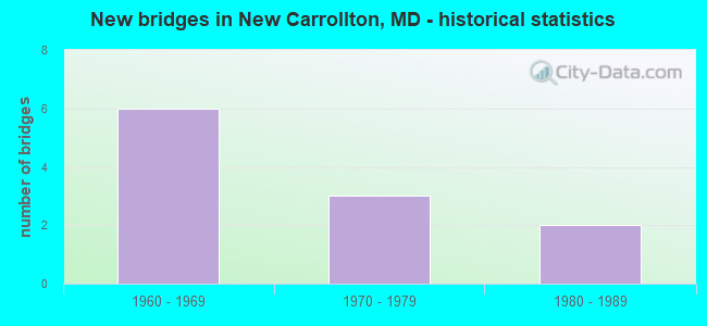
- New bridges - historical statistics
- 61960-1969
- 31970-1979
- 21980-1989
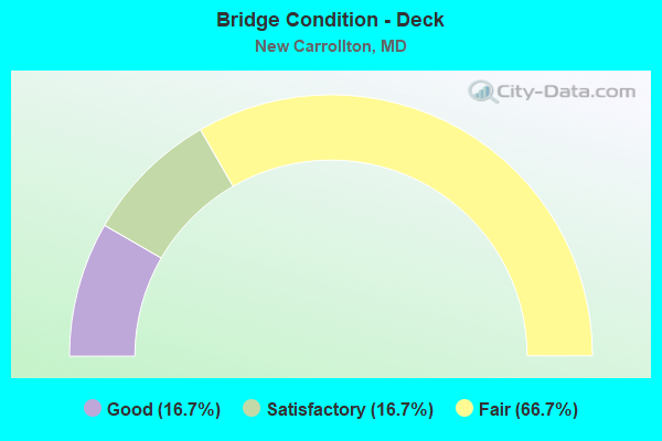
- Bridge Condition - Deck
- 16.7%Good
- 16.7%Satisfactory
- 66.7%Fair
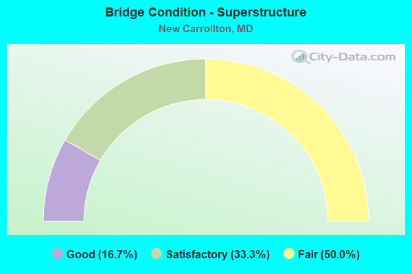
- Bridge Condition - Superstructure
- 16.7%Good
- 33.3%Satisfactory
- 50.0%Fair
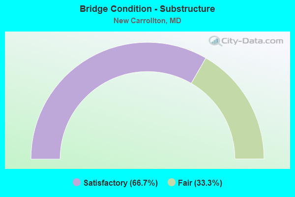
- Bridge Condition - Substructure
- 66.7%Satisfactory
- 33.3%Fair
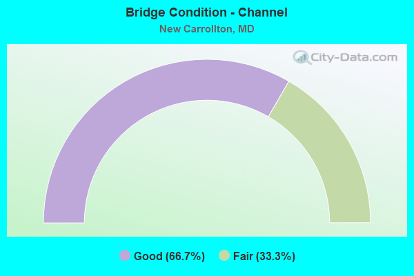
- Bridge Condition - Channel
- 66.7%Good
- 33.3%Fair
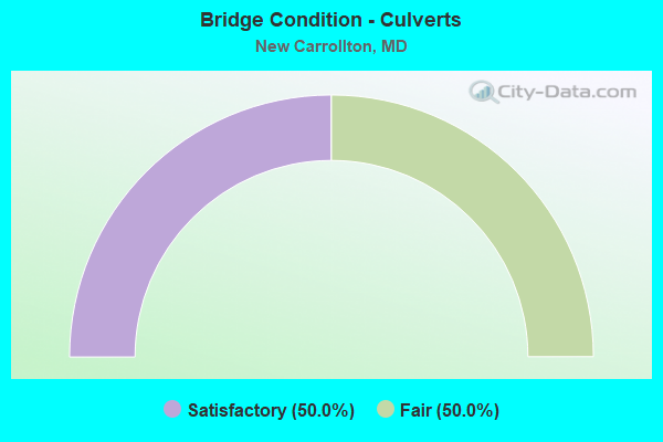
- Bridge Condition - Culverts
- 50.0%Satisfactory
- 50.0%Fair
Find on map >> Show street view
Structure Number: 10000016001401, Location: 0.2 MILE EAST OF MD 564 (Lat: 38.963486, Lng: -76.859061), Route carried "on" structure: State highway 450, Year Built: 1989, Status: Open, Structure Length: 8.63m (28.31ft), Average Daily Traffic: 36,261 (year 2020), Truck Traffic: 6%, Average Future Daily Traffic: 71,874 (year 2040), Design Load: HS 20, Features Intersected: MD 564 EBR, AMTRAK
Minimum Vertical Clearance: 30+ m (98+ ft), Kilometerpoint: 8.286, Lanes on structure: 4, Lanes under structure: 2, Owner: State Highway Agency, Approaching Roadway Width: 15.2m (49.9ft), Skew: 24 degrees, Material/Design: Steel continuous, Design/Construction: Stringer/Multi-beam, Number Of Spans In Main Unit: 3, Length of Maximum Span: 33.5m (109.9ft), Curb or Sidewalk Widths: Left: 1.6m (5.2ft), Right: 0.0m, Curb-To-Curb Width: 15.2m (49.9ft), Out-to-Out Width: 19.5m (64.0ft)
Condition: Deck: Good, Superstructure: Good, Substructure: Satisfactory, Operating Rating: 49.9 metric tons, Method Used To Determine Operating Rating: Load Factor (LF), Inventory Rating: 29.9 metric tons, Method Used To Determine Inventory Rating: Load Factor (LF), Structural Evaluation: Equal to present minimum criteria, Deck Geometry: High priority of corrective action, Underclear: Equal to present minimum criteria, Approach Roadway Alignment: Equal to present minimum criteria, Designated Inspection Frequency: Every 24 months, Inspection Date: June 2020, Deck Structure Type: Concrete Cast-file-Place, Wearing Surface/Protective System: Wearing Surface: Integral Concrete, Deck Protection: Epoxy Coated Reinforcing
Find on map >> Show street view
Structure Number: 100000160143015, Location: 1.15 MILES S OF MD 295 (Lat: 38.978111, Lng: -76.873414), Route carried "on" structure: Interstate 95, Year Built: 1963, Status: Open, Structure Length: 3.84m (12.60ft), Average Daily Traffic: 204,147 (year 2009), Truck Traffic: 8%, Average Future Daily Traffic: 233,787 (year 2029), Design Load: HS 20, Features Intersected: GOOD LUCK ROAD
Minimum Vertical Clearance: 30+ m (98+ ft), Kilometerpoint: 33.721, Lanes on structure: 4, Lanes under structure: 2, Base Highway Network: Yes, Owner: State Highway Agency, Approaching Roadway Width: 19.5m (64.0ft), Material/Design: Steel, Design/Construction: Stringer/Multi-beam, Number Of Spans In Main Unit: 3, Length of Maximum Span: 18.0m (59.1ft), Curb-To-Curb Width: 20.7m (67.9ft), Out-to-Out Width: 21.3m (69.9ft)
Condition: Deck: Fair, Superstructure: Fair, Substructure: Satisfactory, Operating Rating: 59.0 metric tons, Method Used To Determine Operating Rating: Load Factor (LF), Inventory Rating: 35.4 metric tons, Method Used To Determine Inventory Rating: Load Factor (LF), Structural Evaluation: Somewhat better than minimum adequacy, Deck Geometry: Equal to present minimum criteria, Underclear: Meets minimum limits, Approach Roadway Alignment: Equal to present desirable criteria, Length Of Structure Improvement: 3.84m (12.60ft), Designated Inspection Frequency: Every 24 months, Inspection Date: Febuary 2020, Bridge Improvement Cost: $529,000, Roadway Improvement Cost: $53,000, Total Project Cost: $582,000, Deck Structure Type: Concrete Cast-file-Place, Wearing Surface/Protective System: Wearing Surface: Bituminous
Find on map >> Show street view
Structure Number: 100000160143016, Location: 1.15 MILES S OF MD 295 (Lat: 38.978228, Lng: -76.873944), Route carried "on" structure: Interstate 95, Year Built: 1963, Status: Open, Structure Length: 3.84m (12.60ft), Average Daily Traffic: 204,147 (year 2009), Truck Traffic: 8%, Average Future Daily Traffic: 233,787 (year 2029), Design Load: HS 20, Features Intersected: GOOD LUCK ROAD
Minimum Vertical Clearance: 30+ m (98+ ft), Kilometerpoint: 33.721, Lanes on structure: 4, Lanes under structure: 2, Base Highway Network: Yes, Owner: State Highway Agency, Approaching Roadway Width: 19.5m (64.0ft), Material/Design: Steel, Design/Construction: Stringer/Multi-beam, Number Of Spans In Main Unit: 3, Length of Maximum Span: 18.0m (59.1ft), Curb-To-Curb Width: 20.7m (67.9ft), Out-to-Out Width: 21.3m (69.9ft)
Condition: Deck: Fair, Superstructure: Fair, Substructure: Fair, Operating Rating: 60.8 metric tons, Method Used To Determine Operating Rating: Load Factor (LF), Inventory Rating: 36.3 metric tons, Method Used To Determine Inventory Rating: Load Factor (LF), Structural Evaluation: Somewhat better than minimum adequacy, Deck Geometry: Equal to present minimum criteria, Underclear: Meets minimum limits, Approach Roadway Alignment: Equal to present desirable criteria, Length Of Structure Improvement: 3.84m (12.60ft), Designated Inspection Frequency: Every 24 months, Inspection Date: Febuary 2020, Bridge Improvement Cost: $1,058,000, Roadway Improvement Cost: $106,000, Total Project Cost: $1,164,000, Deck Structure Type: Concrete Cast-file-Place, Wearing Surface/Protective System: Wearing Surface: Bituminous
Find on map >> Show street view
Structure Number: 100000160145015, Location: 0.18 MILE SOUTH OF MD 450 (Lat: 38.957081, Lng: -76.865122), Route carried "on" structure: Interstate 95, Year Built: 1964, Year Reconstructed: 1990, Status: Open, Structure Length: 7.56m (24.80ft), Average Daily Traffic: 226,100 (year 2020), Truck Traffic: 8%, Average Future Daily Traffic: 217,662 (year 2040), Design Load: HS 20, Features Intersected: AMTRAK
Minimum Vertical Clearance: 30+ m (98+ ft), Kilometerpoint: 31.207, Lanes on structure: 4, Base Highway Network: Yes, Owner: State Highway Agency, Approaching Roadway Width: 18.6m (61.0ft), Skew: 3 degrees, Material/Design: Steel, Design/Construction: Stringer/Multi-beam, Number Of Spans In Main Unit: 3, Length of Maximum Span: 29.0m (95.1ft), Curb-To-Curb Width: 18.6m (61.0ft), Out-to-Out Width: 19.9m (65.3ft)
Condition: Deck: Fair, Superstructure: Satisfactory, Substructure: Fair, Inventory Rating: 57.6 metric tons, Method Used To Determine Inventory Rating: Load Factor (LF), Structural Evaluation: Somewhat better than minimum adequacy, Deck Geometry: Meets minimum limits, Underclear: Somewhat better than minimum adequacy, Approach Roadway Alignment: Equal to present desirable criteria, Length Of Structure Improvement: 7.56m (24.80ft), Designated Inspection Frequency: Every 24 months, Inspection Date: Febuary 2021, Bridge Improvement Cost: $970,000, Roadway Improvement Cost: $97,000, Total Project Cost: $1,067,000, Deck Structure Type: Concrete Cast-file-Place, Wearing Surface/Protective System: Wearing Surface: Bituminous
Find on map >> Show street view
Structure Number: 100000160145016, Location: 0.18 MILE SOUTH OF MD 450 (Lat: 38.957303, Lng: -76.864956), Route carried "on" structure: Interstate 95, Year Built: 1964, Year Reconstructed: 1990, Status: Open, Structure Length: 7.56m (24.80ft), Average Daily Traffic: 226,100 (year 2020), Truck Traffic: 8%, Average Future Daily Traffic: 217,662 (year 2040), Design Load: HS 20, Features Intersected: AMTRAK
Minimum Vertical Clearance: 30+ m (98+ ft), Kilometerpoint: 31.207, Lanes on structure: 5, Base Highway Network: Yes, Owner: State Highway Agency, Approaching Roadway Width: 22.3m (73.2ft), Skew: 3 degrees, Material/Design: Steel, Design/Construction: Stringer/Multi-beam, Number Of Spans In Main Unit: 3, Length of Maximum Span: 29.0m (95.1ft), Curb-To-Curb Width: 22.3m (73.2ft), Out-to-Out Width: 23.5m (77.1ft)
Condition: Deck: Satisfactory, Superstructure: Satisfactory, Substructure: Satisfactory, Operating Rating: 60.8 metric tons, Method Used To Determine Operating Rating: Load Factor (LF), Inventory Rating: 36.3 metric tons, Method Used To Determine Inventory Rating: Load Factor (LF), Structural Evaluation: Equal to present minimum criteria, Deck Geometry: Meets minimum limits, Underclear: Somewhat better than minimum adequacy, Approach Roadway Alignment: Equal to present desirable criteria, Length Of Structure Improvement: 7.56m (24.80ft), Designated Inspection Frequency: Every 24 months, Inspection Date: Febuary 2021, Bridge Improvement Cost: $1,149,000, Roadway Improvement Cost: $115,000, Total Project Cost: $1,264,000, Deck Structure Type: Concrete Cast-file-Place, Wearing Surface/Protective System: Wearing Surface: Bituminous
Find on map >> Show street view
Structure Number: 200000P-N-0101, Location: AT WESTBROOK DRIVE (Lat: 38.965597, Lng: -76.873481), Route carried "on" structure: City street 490, Year Built: 1975, Status: Posted for load, Structure Length: 1.13m (3.71ft), Average Daily Traffic: 1,544 (year 2019), Truck Traffic: 2%, Average Future Daily Traffic: 2,295 (year 2039), Features Intersected: BRIER DITCH, Facility Carried by Structure: POWHATAN STREET
Minimum Vertical Clearance: 30+ m (98+ ft), Kilometerpoint: 1.030, Lanes on structure: 2, Owner: City or Municipal Highway Agency, Approaching Roadway Width: 10.4m (34.1ft), Material/Design: Prestressed concrete, Design/Construction: Slab, Number Of Spans In Main Unit: 1, Length of Maximum Span: 10.7m (35.1ft), Curb or Sidewalk Widths: Left: 1.2m (3.9ft), Right: 1.2m (3.9ft), Curb-To-Curb Width: 8.0m (26.2ft), Out-to-Out Width: 11.1m (36.4ft)
Condition: Deck: Fair, Superstructure: Fair, Substructure: Satisfactory, Channel: Good, Operating Rating: 62.1 metric tons, Method Used To Determine Operating Rating: Load Factor (LF), Inventory Rating: 37.2 metric tons, Method Used To Determine Inventory Rating: Load Factor (LF), Structural Evaluation: Somewhat better than minimum adequacy, Deck Geometry: Meets minimum limits, Waterway Adequacy: Better than present minimum criteria, Approach Roadway Alignment: Equal to present minimum criteria, Length Of Structure Improvement: 1.13m (3.71ft), Designated Inspection Frequency: Every 24 months, Inspection Date: Febuary 2021, Bridge Improvement Cost: $204,000, Roadway Improvement Cost: $21,000, Total Project Cost: $225,000, Wearing Surface/Protective System: Wearing Surface: Bituminous
Find on map >> Show street view
Structure Number: 200000P-N-0203, Location: 0.01 M S OF CARROLTN PKWY (Lat: 38.969625, Lng: -76.880189), Route carried "on" structure: City street 260, Year Built: 1970, Status: Open, Structure Length: 0.67m (2.20ft), Average Daily Traffic: 8,306 (year 2021), Truck Traffic: 10%, Average Future Daily Traffic: 11,986 (year 2041), Features Intersected: TRIBUTARY TO BRIER DITCH, Facility Carried by Structure: LAMONT DRIVE
Minimum Vertical Clearance: 30+ m (98+ ft), Kilometerpoint: 0.660, Lanes on structure: 2, Owner: City or Municipal Highway Agency, Approaching Roadway Width: 11.0m (36.1ft), Material/Design: Steel, Design/Construction: Culvert, Number Of Spans In Main Unit: 2, Length of Maximum Span: 3.0m (9.8ft), Curb or Sidewalk Widths: Left: 4.4m (14.4ft), Right: 4.4m (14.4ft), Curb-To-Curb Width: 11.1m (36.4ft), Out-to-Out Width: 19.8m (65.0ft)
Condition: Channel: Fair, Culverts: Fair, Structural Evaluation: Somewhat better than minimum adequacy, Deck Geometry: Meets minimum limits, Waterway Adequacy: Somewhat better than minimum adequacy, Approach Roadway Alignment: Equal to present desirable criteria, Length Of Structure Improvement: 0.91m (2.99ft), Designated Inspection Frequency: Every 24 months, Inspection Date: January 2021, Bridge Improvement Cost: $100,000, Roadway Improvement Cost: $100,000, Total Project Cost: $400,000
Find on map >> Show street view
Structure Number: 200000P-N-0303, Location: AT WESTBROOK DRIVE (Lat: 38.965661, Lng: -76.880358), Route carried "on" structure: City street 260, Year Built: 1970, Status: Open, Structure Length: 0.73m (2.40ft), Average Daily Traffic: 8,194 (year 2021), Truck Traffic: 10%, Average Future Daily Traffic: 12,176 (year 2041), Features Intersected: BRIER DITCH, Facility Carried by Structure: LAMONT DRIVE
Minimum Vertical Clearance: 30+ m (98+ ft), Kilometerpoint: 1.110, Lanes on structure: 2, Owner: City or Municipal Highway Agency, Approaching Roadway Width: 11.0m (36.1ft), Material/Design: Steel, Design/Construction: Culvert, Number Of Spans In Main Unit: 2, Length of Maximum Span: 3.4m (11.2ft), Curb or Sidewalk Widths: Left: 3.4m (11.2ft), Right: 3.4m (11.2ft)
Condition: Channel: Good, Culverts: Satisfactory, Inventory Rating: 59.0 metric tons, Method Used To Determine Inventory Rating: Load Factor (LF), Structural Evaluation: Equal to present minimum criteria, Waterway Adequacy: Equal to present minimum criteria, Approach Roadway Alignment: Equal to present desirable criteria, Length Of Structure Improvement: 0.91m (2.99ft), Designated Inspection Frequency: Every 24 months, Inspection Date: January 2021, Bridge Improvement Cost: $350,000, Roadway Improvement Cost: $35,000, Total Project Cost: $385,000
Find on map >> Show street view
Structure Number: 10000016001401, Location: 0.01 M W OF CIPRIANO ROAD (Lat: 38.963508, Lng: -76.859047), Route carried "under" structure: State highway 564, Year Built: 1989, Structure Length: 0. m, Average Daily Traffic: 18,290 (year 2009), Truck Traffic: 8%, Features Intersected: MD 564 EBR, Facility Carried by Structure: MD 450
Minimum Vertical Clearance: 5.18m (16.99ft), Kilometerpoint: 0.338, Lanes on structure: 4, Lanes under structure: 2, Material/Design: Steel continuous, Design/Construction: Stringer/Multi-beam, Length of Maximum Span: 33.5m (109.9ft)
Find on map >> Show street view
Structure Number: 100000160143015, Location: 1.15 MILES S OF MD 295 (Lat: 38.978111, Lng: -76.873414), Route carried "under" structure: County highway 42, Year Built: 1963, Structure Length: 0. m, Average Daily Traffic: 18,510 (year 2012), Features Intersected: GOOD LUCK ROAD, Facility Carried by Structure: IS 95 IL
Minimum Vertical Clearance: 4.88m (16.01ft), Kilometerpoint: 6.034, Lanes on structure: 4, Lanes under structure: 2, Material/Design: Steel, Design/Construction: Stringer/Multi-beam, Length of Maximum Span: 18.0m (59.1ft)
Find on map >> Show street view
Structure Number: 100000160143016, Location: 1.15 MILES S OF MD 295 (Lat: 38.978228, Lng: -76.873944), Route carried "under" structure: County highway 42, Year Built: 1963, Structure Length: 0. m, Average Daily Traffic: 18,510 (year 2012), Features Intersected: GOOD LUCK ROAD, Facility Carried by Structure: IS 95 OL
Minimum Vertical Clearance: 4.88m (16.01ft), Kilometerpoint: 6.066, Lanes on structure: 4, Lanes under structure: 2, Material/Design: Steel, Design/Construction: Stringer/Multi-beam, Length of Maximum Span: 18.0m (59.1ft)