Bridge Statistics for New Haven, West Virginia (WV)
Condition, Traffic, Stress, Structural Evaluation, Project Costs
- National Bridge Inventory (NBI) Statistics
- 14Number of bridges
- 56ft / 17.1mTotal length
- $1,100,000Total costs
- 7,550Total average daily traffic
- 441Total average daily truck traffic
- National Bridge Inventory (NBI) Registered Bridges for New Haven
- No street view available for this location
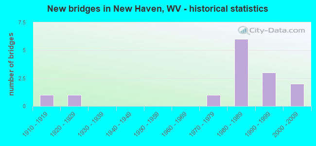
- New bridges - historical statistics
- 11910-1919
- 11920-1929
- 11970-1979
- 61980-1989
- 31990-1999
- 22000-2009

- Bridge Condition - Deck
- 80.0%Good
- 20.0%Satisfactory

- Bridge Condition - Superstructure
- 10.0%Very good
- 70.0%Good
- 20.0%Satisfactory

- Bridge Condition - Substructure
- 40.0%Good
- 30.0%Satisfactory
- 30.0%Fair

- Bridge Condition - Channel
- 10.0%Very good
- 20.0%Good
- 10.0%Satisfactory
- 50.0%Fair
- 10.0%Poor
Find on map >> Show street view
Structure Number: 27A012, Location: 0.22 MI E OF CR 9/4 (Lat: 38.962350, Lng: -81.960919), Route carried "on" structure: County highway 6, Year Built: 1980, Status: Open, Structure Length: 1.42m (4.66ft), Average Daily Traffic: 200 (year 2019), Truck Traffic: 5%, Average Future Daily Traffic: 260 (year 2039), Design Load: HS 20, Features Intersected: BROAD RUN
Minimum Vertical Clearance: 30+ m (98+ ft), Kilometerpoint: 5.375, Lanes on structure: 2, Owner: State Highway Agency, Approaching Roadway Width: 4.0m (13.1ft), Material/Design: Prestressed concrete, Design/Construction: Box Beam or Girders - Multiple, Number Of Spans In Main Unit: 1, Length of Maximum Span: 13.7m (44.9ft), Curb-To-Curb Width: 5.5m (18.0ft), Out-to-Out Width: 5.5m (18.0ft)
Condition: Deck: Good, Superstructure: Good, Substructure: Fair, Channel: Good, Operating Rating: 88.9 metric tons, Method Used To Determine Operating Rating: Load Factor (LF), Inventory Rating: 58.0 metric tons, Method Used To Determine Inventory Rating: Load Factor (LF), Structural Evaluation: Somewhat better than minimum adequacy, Deck Geometry: High priority of corrective action, Waterway Adequacy: Equal to present minimum criteria, Approach Roadway Alignment: Equal to present minimum criteria, Designated Inspection Frequency: Every 24 months, Inspection Date: March 2021, Deck Structure Type: Other, Wearing Surface/Protective System: Wearing Surface: Bituminous
Find on map >> Show street view
Structure Number: 27A013, Location: 0.98 MI W OF WV 62 (Lat: 38.974831, Lng: -81.954789), Route carried "on" structure: County highway 6, Year Built: 1918, Status: Posted for load, Structure Length: 0.98m (3.22ft), Average Daily Traffic: 200 (year 2018), Truck Traffic: 5%, Average Future Daily Traffic: 260 (year 2038), Features Intersected: BROAD RUN
Minimum Vertical Clearance: 30+ m (98+ ft), Kilometerpoint: 6.904, Lanes on structure: 1, Owner: State Highway Agency, Approaching Roadway Width: 3.7m (12.1ft), Material/Design: Concrete, Design/Construction: Slab, Number Of Spans In Main Unit: 1, Length of Maximum Span: 9.4m (30.8ft), Curb-To-Curb Width: 4.1m (13.5ft), Out-to-Out Width: 4.8m (15.7ft)
Condition: Deck: Good, Superstructure: Good, Substructure: Satisfactory, Channel: Fair, Operating Rating: 47.2 metric tons, Method Used To Determine Operating Rating: Field evaluation and documented engineering judgment, Inventory Rating: 21.8 metric tons, Method Used To Determine Inventory Rating: Field evaluation and documented engineering judgment, Structural Evaluation: Equal to present minimum criteria, Deck Geometry: High priority of replacement, Waterway Adequacy: Equal to present minimum criteria, Approach Roadway Alignment: Equal to present minimum criteria, Bridge Posting: Required (Relationship of Operating Rating to Maximum Legal Load: 0.1 - 9.9% below), Length Of Structure Improvement: 1.22m (4.00ft), Designated Inspection Frequency: Every 24 months, Inspection Date: March 2021, Bridge Improvement Cost: $400,000, Roadway Improvement Cost: $50,000, Total Project Cost: $450,000 ( Estimate for 2021), Deck Structure Type: Other, Wearing Surface/Protective System: Wearing Surface: Bituminous
Find on map >> Show street view
Structure Number: 27A014, Location: 0.75 MI W OF WV 62 (Lat: 38.976750, Lng: -81.953981), Route carried "on" structure: County highway 6, Year Built: 1980, Status: Open, Structure Length: 1.37m (4.49ft), Average Daily Traffic: 200 (year 2018), Truck Traffic: 5%, Average Future Daily Traffic: 260 (year 2038), Design Load: HS 20, Features Intersected: BROAD RUN
Minimum Vertical Clearance: 30+ m (98+ ft), Kilometerpoint: 7.274, Lanes on structure: 2, Owner: State Highway Agency, Approaching Roadway Width: 4.6m (15.1ft), Material/Design: Prestressed concrete, Design/Construction: Box Beam or Girders - Multiple, Number Of Spans In Main Unit: 1, Length of Maximum Span: 13.3m (43.6ft), Curb-To-Curb Width: 5.5m (18.0ft), Out-to-Out Width: 5.5m (18.0ft)
Condition: Deck: Good, Superstructure: Good, Substructure: Fair, Channel: Fair, Operating Rating: 68.9 metric tons, Method Used To Determine Operating Rating: Load Factor (LF), Inventory Rating: 41.7 metric tons, Method Used To Determine Inventory Rating: Load Factor (LF), Structural Evaluation: Somewhat better than minimum adequacy, Deck Geometry: High priority of corrective action, Waterway Adequacy: Meets minimum limits, Approach Roadway Alignment: Better than present minimum criteria, Length Of Structure Improvement: 1.37m (4.49ft), Designated Inspection Frequency: Every 24 months, Inspection Date: March 2021, Bridge Improvement Cost: $75,000, Roadway Improvement Cost: $25,000, Total Project Cost: $100,000 ( Estimate for 2021), Deck Structure Type: Other, Wearing Surface/Protective System: Wearing Surface: Bituminous
Find on map >> Show street view
Structure Number: 27A019, Location: 0.10 MI N OF CR 9/3 (Lat: 38.958689, Lng: -81.962769), Route carried "on" structure: County highway 94, Year Built: 1988, Status: Open, Structure Length: 1.81m (5.94ft), Average Daily Traffic: 300 (year 2018), Truck Traffic: 5%, Average Future Daily Traffic: 390 (year 2038), Design Load: HS 25 or greater, Features Intersected: BROAD RUN, Facility Carried by Structure: CR 009/04
Minimum Vertical Clearance: 30+ m (98+ ft), Kilometerpoint: 1.271, Lanes on structure: 2, Owner: State Highway Agency, Approaching Roadway Width: 4.9m (16.1ft), Material/Design: Prestressed concrete, Design/Construction: Box Beam or Girders - Multiple, Number Of Spans In Main Unit: 1, Length of Maximum Span: 17.7m (58.1ft), Curb-To-Curb Width: 6.4m (21.0ft), Out-to-Out Width: 6.4m (21.0ft)
Condition: Deck: Good, Superstructure: Satisfactory, Substructure: Satisfactory, Channel: Fair, Operating Rating: 81.6 metric tons, Method Used To Determine Operating Rating: Load Factor (LF), Inventory Rating: 49.0 metric tons, Method Used To Determine Inventory Rating: Load Factor (LF), Structural Evaluation: Equal to present minimum criteria, Deck Geometry: Meets minimum limits, Waterway Adequacy: Equal to present minimum criteria, Approach Roadway Alignment: Better than present minimum criteria, Designated Inspection Frequency: Every 24 months, Inspection Date: April 2020, Deck Structure Type: Other, Wearing Surface/Protective System: Wearing Surface: Bituminous, Deck Protection: Epoxy Coated Reinforcing
Find on map >> Show street view
Structure Number: 27A106, Location: 0.23 MI S OF CO 9/4 (Lat: 38.955569, Lng: -81.964961), Route carried "on" structure: County highway 93, Year Built: 1990, Status: Open, Structure Length: 1.51m (4.95ft), Average Daily Traffic: 90 (year 2018), Truck Traffic: 5%, Average Future Daily Traffic: 117 (year 2038), Design Load: HS 25 or greater, Features Intersected: BROAD RUN, Facility Carried by Structure: CR 009/03
Minimum Vertical Clearance: 30+ m (98+ ft), Kilometerpoint: 3.524, Lanes on structure: 2, Owner: State Highway Agency, Approaching Roadway Width: 4.9m (16.1ft), Material/Design: Prestressed concrete, Design/Construction: Box Beam or Girders - Multiple, Number Of Spans In Main Unit: 1, Length of Maximum Span: 14.6m (47.9ft), Curb-To-Curb Width: 5.5m (18.0ft), Out-to-Out Width: 5.5m (18.0ft)
Condition: Deck: Good, Superstructure: Satisfactory, Substructure: Good, Channel: Very good, Operating Rating: 88.9 metric tons, Method Used To Determine Operating Rating: Load Factor (LF), Inventory Rating: 64.4 metric tons, Method Used To Determine Inventory Rating: Load Factor (LF), Structural Evaluation: Equal to present minimum criteria, Deck Geometry: Meets minimum limits, Waterway Adequacy: Better than present minimum criteria, Approach Roadway Alignment: Better than present minimum criteria, Designated Inspection Frequency: Every 24 months, Inspection Date: April 2020, Deck Structure Type: Other, Wearing Surface/Protective System: Wearing Surface: Bituminous, Deck Protection: Epoxy Coated Reinforcing
Find on map >> Show street view
Structure Number: 27A109, Location: 0.42 MI. N. OF WV 62 (Lat: 38.990261, Lng: -81.962981), Route carried "on" structure: County highway 1900, Year Built: 1981, Status: Open, Structure Length: 5.81m (19.06ft), Average Daily Traffic: 1,100 (year 2018), Truck Traffic: 5%, Average Future Daily Traffic: 1,430 (year 2038), Design Load: HS 20, Features Intersected: BROAD RUN, Facility Carried by Structure: CR 19
Minimum Vertical Clearance: 30+ m (98+ ft), Kilometerpoint: 0.676, Lanes on structure: 2, Owner: State Highway Agency, Approaching Roadway Width: 6.7m (22.0ft), Material/Design: Steel continuous, Design/Construction: Stringer/Multi-beam, Number Of Spans In Main Unit: 1, Number Of Approach Spans: 2, Length of Maximum Span: 22.3m (73.2ft), Curb or Sidewalk Widths: Left: 0.0m, Right: 1.5m (4.9ft), Curb-To-Curb Width: 6.7m (22.0ft), Out-to-Out Width: 7.9m (25.9ft)
Condition: Deck: Satisfactory, Superstructure: Good, Substructure: Good, Channel: Fair, Operating Rating: 76.2 metric tons, Method Used To Determine Operating Rating: Load Factor (LF), Inventory Rating: 45.4 metric tons, Method Used To Determine Inventory Rating: Load Factor (LF), Structural Evaluation: Better than present minimum criteria, Deck Geometry: High priority of corrective action, Waterway Adequacy: Equal to present desirable criteria, Approach Roadway Alignment: Equal to present minimum criteria, Length Of Structure Improvement: 5.81m (19.06ft), Designated Inspection Frequency: Every 24 months, Inspection Date: March 2021, Bridge Improvement Cost: $400,000, Roadway Improvement Cost: $50,000, Total Project Cost: $450,000 ( Estimate for 2021), Deck Structure Type: Concrete Cast-file-Place, Wearing Surface/Protective System: Wearing Surface: Monolithic Concrete, Deck Protection: Epoxy Coated Reinforcing
Find on map >> Show street view
Structure Number: 27A122, Location: 0.21 MI W OF WV 62 (Lat: 38.981600, Lng: -81.959589), Route carried "on" structure: County highway 600, Year Built: 1987, Status: Open, Structure Length: 0.84m (2.76ft), Average Daily Traffic: 200 (year 2018), Truck Traffic: 5%, Average Future Daily Traffic: 260 (year 2038), Design Load: HS 20, Features Intersected: SEAMAN RUN, Facility Carried by Structure: COUNTY ROUTE 6
Minimum Vertical Clearance: 30+ m (98+ ft), Kilometerpoint: 7.725, Lanes on structure: 2, Owner: State Highway Agency, Approaching Roadway Width: 4.3m (14.1ft), Material/Design: Prestressed concrete, Design/Construction: Slab, Number Of Spans In Main Unit: 1, Length of Maximum Span: 7.9m (25.9ft), Curb-To-Curb Width: 5.8m (19.0ft), Out-to-Out Width: 6.1m (20.0ft)
Condition: Deck: Good, Superstructure: Good, Substructure: Fair, Channel: Fair, Operating Rating: 77.1 metric tons, Method Used To Determine Operating Rating: Load Factor (LF), Inventory Rating: 46.3 metric tons, Method Used To Determine Inventory Rating: Load Factor (LF), Structural Evaluation: Somewhat better than minimum adequacy, Deck Geometry: High priority of corrective action, Waterway Adequacy: Somewhat better than minimum adequacy, Approach Roadway Alignment: Equal to present desirable criteria, Designated Inspection Frequency: Every 24 months, Inspection Date: October 2020, Deck Structure Type: Other, Wearing Surface/Protective System: Wearing Surface: Bituminous, Deck Protection: Epoxy Coated Reinforcing
Find on map >> Show street view
Structure Number: 27A13, Location: 0.87 MI E OF CR 9/4 (Lat: 38.971531, Lng: -81.956089), Route carried "on" structure: County highway 6, Year Built: 1986, Status: Open, Structure Length: 0.84m (2.76ft), Average Daily Traffic: 200 (year 2020), Truck Traffic: 6%, Average Future Daily Traffic: 276 (year 2040), Features Intersected: BROAD RUN
Minimum Vertical Clearance: 30+ m (98+ ft), Kilometerpoint: 6.582, Lanes on structure: 2, Owner: State Highway Agency, Approaching Roadway Width: 4.3m (14.1ft), Material/Design: Prestressed concrete, Design/Construction: Slab, Number Of Spans In Main Unit: 1, Length of Maximum Span: 7.9m (25.9ft), Curb-To-Curb Width: 5.8m (19.0ft), Out-to-Out Width: 6.1m (20.0ft)
Condition: Deck: Good, Superstructure: Good, Substructure: Satisfactory, Channel: Poor, Operating Rating: 82.5 metric tons, Method Used To Determine Operating Rating: Load Factor (LF), Inventory Rating: 49.0 metric tons, Method Used To Determine Inventory Rating: Load Factor (LF), Structural Evaluation: Equal to present minimum criteria, Deck Geometry: High priority of corrective action, Waterway Adequacy: Equal to present minimum criteria, Approach Roadway Alignment: Equal to present desirable criteria, Length Of Structure Improvement: 0.84m (2.76ft), Designated Inspection Frequency: Every 24 months, Inspection Date: November 2021, Bridge Improvement Cost: $75,000, Roadway Improvement Cost: $25,000, Total Project Cost: $100,000 ( Estimate for 2019), Deck Structure Type: Other, Wearing Surface/Protective System: Wearing Surface: Bituminous
Find on map >> Show street view
Structure Number: 27A148, Location: 1.10 MILE NORTH OF CR 3 (Lat: 38.941981, Lng: -81.972739), Route carried "on" structure: County highway 93, Year Built: 1999, Status: Open, Structure Length: 1.25m (4.10ft), Average Daily Traffic: 103 (year 2016), Truck Traffic: 5%, Average Future Daily Traffic: 134 (year 2036), Design Load: HS 25 or greater, Features Intersected: BROAD RUN, Facility Carried by Structure: COUNTY ROUTE 9/3
Minimum Vertical Clearance: 30+ m (98+ ft), Kilometerpoint: 1.770, Lanes on structure: 2, Owner: State Highway Agency, Approaching Roadway Width: 4.6m (15.1ft), Skew: 2 degrees, Material/Design: Prestressed concrete, Design/Construction: Box Beam or Girders - Multiple, Number Of Spans In Main Unit: 1, Length of Maximum Span: 11.4m (37.4ft), Curb-To-Curb Width: 6.5m (21.3ft), Out-to-Out Width: 6.5m (21.3ft)
Condition: Deck: Satisfactory, Superstructure: Good, Substructure: Good, Channel: Satisfactory, Operating Rating: 82.5 metric tons, Method Used To Determine Operating Rating: Load Factor (LF), Inventory Rating: 49.9 metric tons, Method Used To Determine Inventory Rating: Load Factor (LF), Structural Evaluation: Better than present minimum criteria, Deck Geometry: Meets minimum limits, Waterway Adequacy: Equal to present minimum criteria, Approach Roadway Alignment: Equal to present minimum criteria, Designated Inspection Frequency: Every 48 months, Inspection Date: January 2018, Deck Structure Type: Other, Wearing Surface/Protective System: Wearing Surface: Monolithic Concrete, Deck Protection: Epoxy Coated Reinforcing
Find on map >> Show street view
Structure Number: 27A149, Location: 0.80 MILE NORTH OF CR 3 (Lat: 38.938300, Lng: -81.972719), Route carried "on" structure: County highway 93, Year Built: 1999, Status: Open, Structure Length: 1.26m (4.13ft), Average Daily Traffic: 103 (year 2016), Truck Traffic: 5%, Average Future Daily Traffic: 134 (year 2036), Design Load: HS 25 or greater, Features Intersected: BROAD RUN, Facility Carried by Structure: COUNTY ROUTE 9/3
Minimum Vertical Clearance: 30+ m (98+ ft), Kilometerpoint: 1.287, Lanes on structure: 1, Owner: State Highway Agency, Approaching Roadway Width: 4.3m (14.1ft), Material/Design: Prestressed concrete, Design/Construction: Box Beam or Girders - Multiple, Number Of Spans In Main Unit: 1, Length of Maximum Span: 11.6m (38.1ft), Curb or Sidewalk Widths: Left: 0.2m (0.7ft), Right: 0.2m (0.7ft), Curb-To-Curb Width: 4.1m (13.5ft), Out-to-Out Width: 4.6m (15.1ft)
Condition: Deck: Good, Superstructure: Very good, Substructure: Good, Channel: Good, Operating Rating: 75.3 metric tons, Method Used To Determine Operating Rating: Load Factor (LF), Inventory Rating: 44.4 metric tons, Method Used To Determine Inventory Rating: Load Factor (LF), Structural Evaluation: Better than present minimum criteria, Deck Geometry: High priority of replacement, Waterway Adequacy: Meets minimum limits, Approach Roadway Alignment: Equal to present desirable criteria, Designated Inspection Frequency: Every 48 months, Inspection Date: January 2018, Deck Structure Type: Other, Wearing Surface/Protective System: Wearing Surface: Monolithic Concrete, Deck Protection: Epoxy Coated Reinforcing
Find on map >> Show street view
Structure Number: 27A121, Location: 1.01 MI E OF CR 33/13 (Lat: 38.974250, Lng: -81.937381), Route carried "under" structure: State highway 6200, Year Built: 1979, Structure Length: 0. m, Average Daily Traffic: 1,154 (year 2017), Truck Traffic: 8%, Features Intersected: WV 62, Facility Carried by Structure: AEP PIPELINES
Minimum Vertical Clearance: 5.92m (19.42ft), Kilometerpoint: 65.758, Lanes under structure: 2, Material/Design: Steel, Design/Construction: Truss - Thru, Length of Maximum Span: 53.0m (173.9ft)
Find on map >> Show street view
Structure Number: 27A163, Location: 0.34 MI N. OF WV 62 F (Lat: 38.989869, Lng: -81.964411), Route carried "under" structure: County highway 1900, Year Built: 1928, Structure Length: 0. m, Average Daily Traffic: 900 (year 2020), Truck Traffic: 5%, Features Intersected: COUNTY ROUTE 19, Facility Carried by Structure: CSX RR OWNER #1527
Minimum Vertical Clearance: 4.19m (13.75ft), Kilometerpoint: 0.547, Lanes under structure: 2, Material/Design: Steel, Design/Construction: Stringer/Multi-beam, Length of Maximum Span: 8.5m (27.9ft)
Find on map >> Show street view
Structure Number: 27A167, Location: 1.00 MI N. OF CR 33/13 (Lat: 38.974331, Lng: -81.937450), Route carried "under" structure: State highway 62, Year Built: 2005, Structure Length: 0. m, Average Daily Traffic: 1,400 (year 2019), Truck Traffic: 6%, Features Intersected: WV 62, Facility Carried by Structure: AEP COAL CONVEYOR
Minimum Vertical Clearance: 5.94m (19.49ft), Kilometerpoint: 65.742, Lanes under structure: 2, Material/Design: Steel, Design/Construction: Truss - Thru, Length of Maximum Span: 53.0m (173.9ft)
Find on map >> Show street view
Structure Number: 27A168, Location: 0.20 MI N. OF CR 33/13 (Lat: 38.981861, Lng: -81.949089), Route carried "under" structure: State highway 62, Year Built: 2007, Structure Length: 0. m, Average Daily Traffic: 1,400 (year 2019), Truck Traffic: 6%, Features Intersected: WV 62, Facility Carried by Structure: NRP COAL CONVEYOR
Minimum Vertical Clearance: 6.71m (22.01ft), Kilometerpoint: 64.454, Lanes under structure: 2, Material/Design: Steel, Length of Maximum Span: 24.4m (80.1ft)